Sunflower Season
Thanks to Roger for the picture below who apparently has a secret to growing massive sunflowers! Good grief Roger... what are you feeding those things?

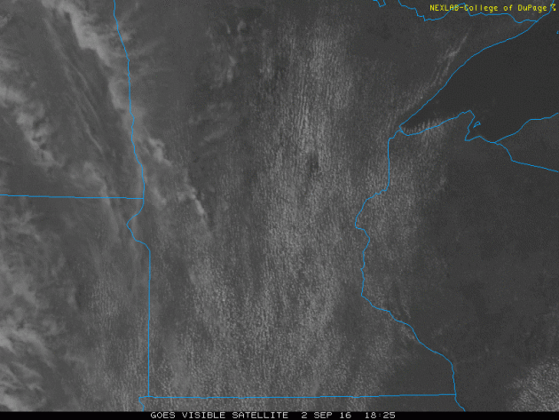
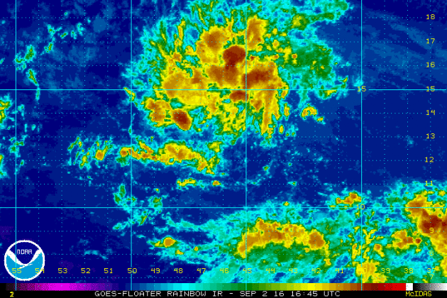
Friday Satellite
Friday was another stunningly beautiful day with near average temps, comfy dewpoints and plentiful sunshine. Note the higher clouds from PM Friday that were streaming into Minnesota from the west. This is from shower and thunderstorm activity that will eventually move in to our neck of the woods late this weekend and into most of next week.
_____________________________
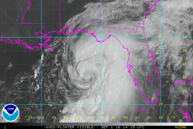
"Further Analysis from RMS on Hurricane Hermine"
"Hurricane Hermine made landfall over northwest Florida at approximately 06:00 UTC (02:00 local time) today, Friday September 2 as a Category 1 storm on the Saffir Simpson Hurricane Wind Scale, with maximum sustained wind speeds of 80 mph (130 km/hr). (1) RMS research has revealed measurable differences in vulnerability between northern Florida, where Hermine made landfall, and the rest of the state, with structures in northern Florida more vulnerable to wind. This is because there are significant differences in North Florida building stock, which is generally wooden-framed, compared with domestic properties in Central and South Florida where the use of masonry is more common. The buildings are also designed to sustain different wind speeds. Another possible reason for the higher vulnerability in northern Florida is that the area is more heavily wooded than highly developed Central Florida. Tree falls, especially from squalls in outer rainbands, can contribute to losses in areas that may not have received the highest winds from the core of the storm. For Hermine, this would be evident in the areas from Tampa northward to Perry. An analysis of wind-related claims from northern Florida related to Hurricane Ivan (2004) showed a higher severity of damage than wind-related claims from historical events which impacted central Florida."
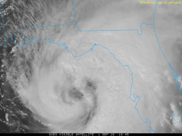
HERMINE at Landfall
Here's a look at Hurricane Hermine just before landfall along the Florida coastline PM Thursday. Outer bands began whipping the state early Thursday, some of which produced severe weather with tornadoes and locally heavy rain. Interestingly, HERMINE was the first hurricane to affect the state since Hurricane Wilma in 2005, 11 years ago.

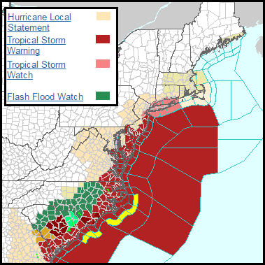
Topical Warnings Continue
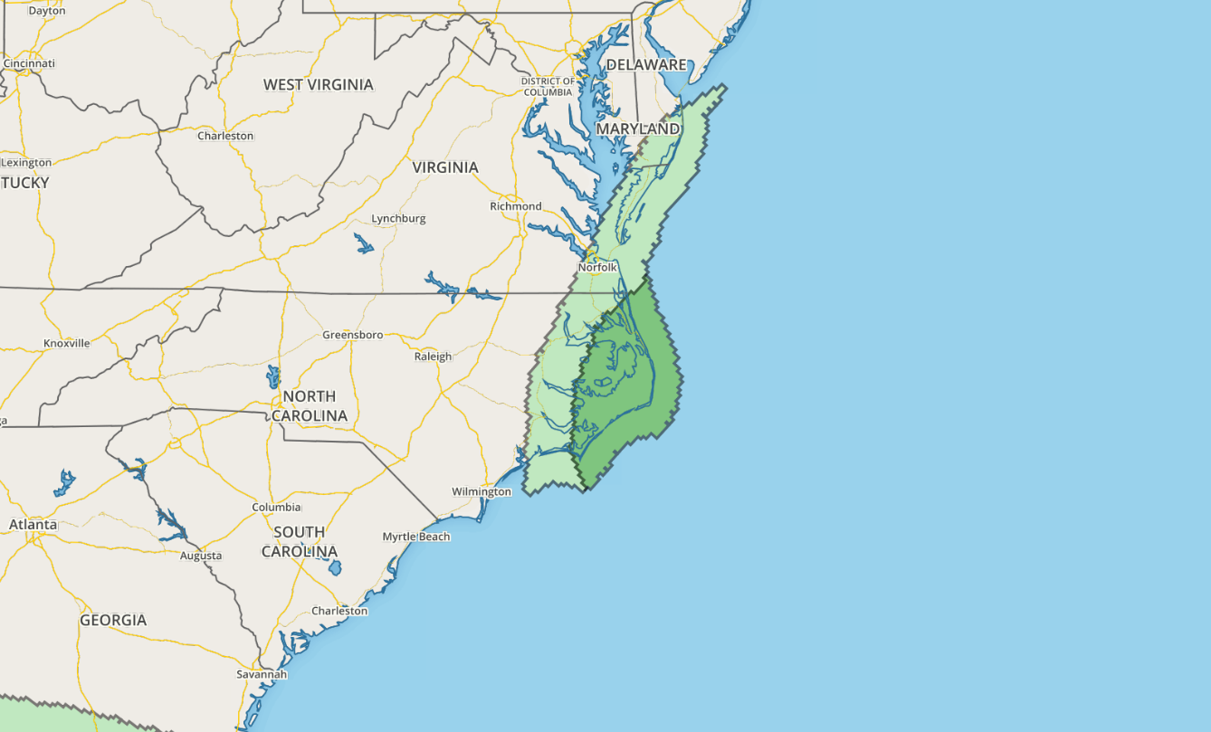
Tropical Watches and Warnings have now been extended to parts of the Northeast, including New York City, in advance of Hermine as if lifts northeast along the coast.
...TROPICAL STORM WATCH REMAINS IN EFFECT...
* LOCATIONS AFFECTED - BATTERY PARK - HARLEM - CENTRAL PARK
* WIND - LATEST LOCAL FORECAST: BELOW TROPICAL STORM FORCE WIND - PEAK WIND FORECAST: 15-25 MPH WITH GUSTS TO 30 MPH
* STORM SURGE - LATEST LOCAL FORECAST: LIFE-THREATENING STORM SURGE POSSIBLE - PEAK STORM SURGE INUNDATION: THE POTENTIAL FOR 2-4 FEET ABOVE GROUND SOMEWHERE WITHIN SURGE PRONE AREAS - WINDOW OF CONCERN: BEGINS SATURDAY EVENING - CURRENT THREAT TO LIFE AND PROPERTY: MODERATE - THE STORM SURGE THREAT HAS REMAINED NEARLY STEADY FROM THE PREVIOUS ASSESSMENT. - EMERGENCY CONSIDERATIONS SHOULD POSTURE FOR A REASONABLE THREAT FOR DANGEROUS STORM SURGE FLOODING OF GREATER THAN 3 FEET ABOVE GROUND.
* FLOODING RAIN - LATEST LOCAL FORECAST: - PEAK RAINFALL AMOUNTS: AROUND 1 INCH
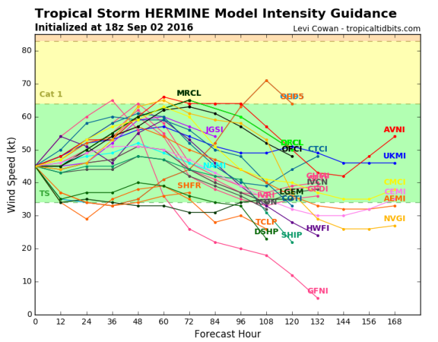
The forecast intensity for Hermine suggests that the overall intensity will remain tropical storm strength over the next several days, however, note that several members bring this storm back to near hurricane strength! This will be something that will have to be monitored as the storm is expected to sit and wobble off the Mid-Atlantic/Northeast Coast through most of next week!
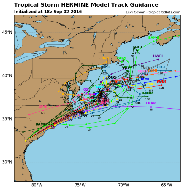
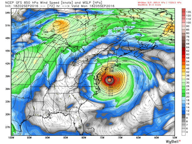
Tracking HERMINE
The forecast track from NOAA's NHC suggests that Hermine will remain a Tropical Storm status after land falling in the Florida Panhandle just after midnight on Friday. However, note that it may remain at Tropical Storm status through Sunday before (potentially) turning back into and hurricane just east of the Delmarva Peninsula. This could definitely be cause for bigger concerns as folks along the coast will be susceptible to strong winds, heavier rain and coastal flooding. This will definitely have to be monitored closely over the next several days... Stay tuned!
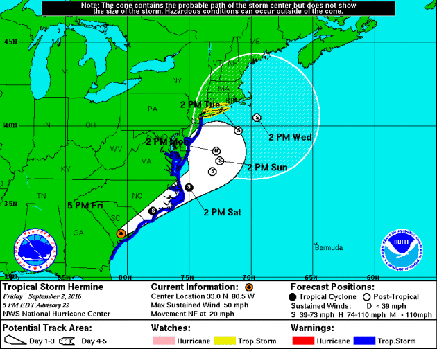
Spaghetti plots seem to be all over the map as Hermine moves back over the open waters of the Atlantic, however, there seems to be a bit of a consensus that the storm may sit offshore for several days before slowly drifting away late next week.
Tracking HERMINE
Here's a forecast view of Hermine midday Monday, which shows a nearly stationary storm just off the Eastern Seaboard. Interestingly, Hermine could strengthen and potentially become a hurricane again as it wobbles of the Eastern Seaboard. Prolonged gusty winds, high coastal surf and heavy rain chances will make the rest of the Labor Day Weekend and much of next week fairly interesting.
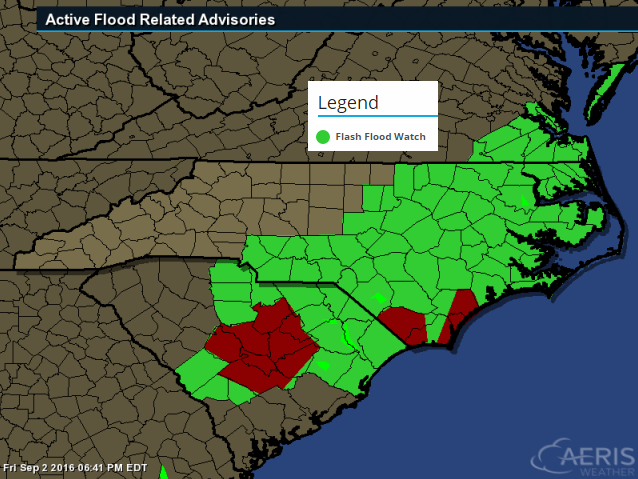
Flash Flood Concerns
The National Weather Service continues Flash Flood Watches across much of eastern North and South Carolina and even parts of Virginia through PM Saturday as heavy rains from Hermine inundate the area. Some spots may still up up to 3" to 6"+ through that time period.
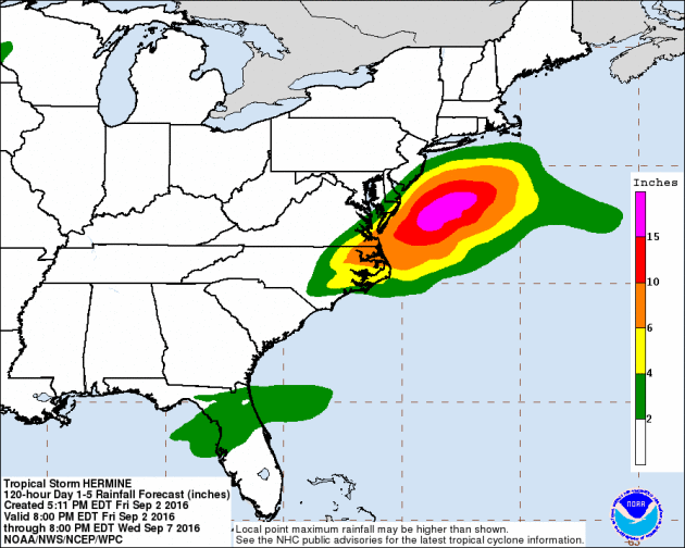
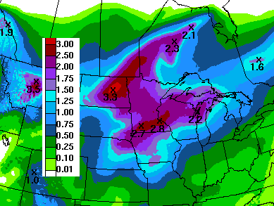
Heavy Rain Potential
One of the main concerns with this particular storm will be the significant rain chances continuing through Saturday. Some models still suggests as much as 3" to 6"+ across parts of eastern North Carolina and southeastern Virginia. However, the heaviest looks to stay just offshore with up to 10" to 15"+ possible through PM Wednesday!
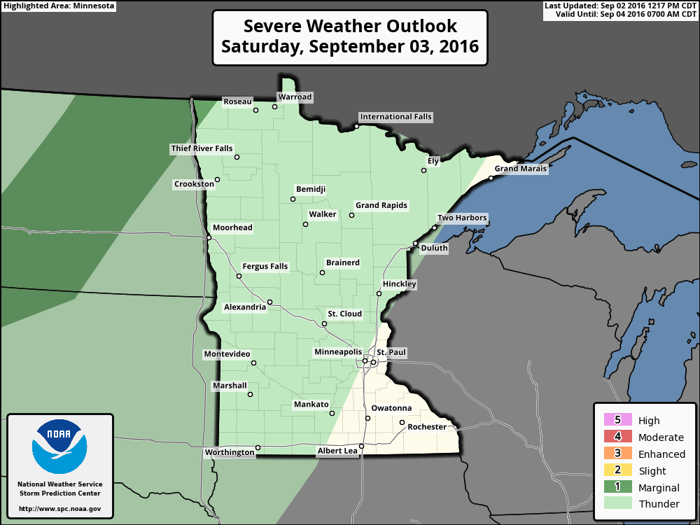
Severe Threat Saturday
As Hermine slides northeast along the Eastern Seaboard, severe thunderstorms may accompany some the individual cells associated with the outer bands spiraling around the main are of circulation. Take a look at the severe threat on Saturday as issued from NOAA's SPC.
...SOUTHERN MID ATLANTIC COAST REGION... BASED ON THE LATEST FORECAST TRACK OF HERMINE...ANY LINGERING ASSOCIATED SEVERE WEATHER POTENTIAL OVER INLAND AREAS SEEMS LIKELY TO DIMINISH BY OR SHORTLY AFTER 12Z SATURDAY.
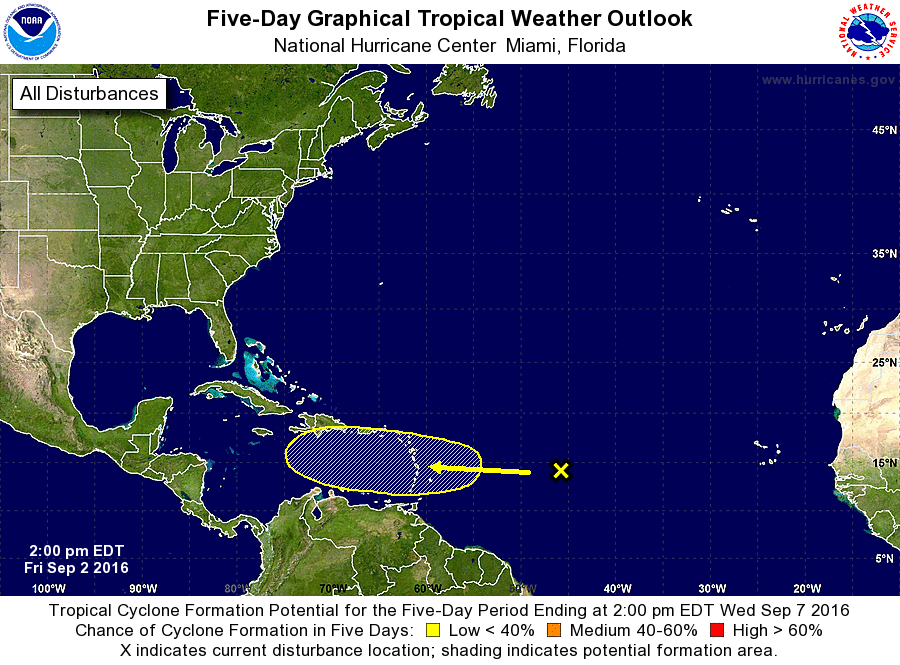
Keeping and Eye on the Atlantic
While it may not look like much yet, NOAA's NHC is keeping an eye on this particular wave of energy as it has a low chance of becoming a tropical cyclone over the next 5 days... Stay tuned!
Atlantic 5 Day Outlook
The National Hurricane Center will continue to watch the wave of energy in the Central Atlantic over the next few days. At this point, the forecast calls for less than a 40% chance of tropical formation within the next 5 days.
___________________________________________________
Stunning Saturday Gives Way to a Stormier Pattern
Last count, I am up to 5 pronto pups, 4 corn on the cobs and 2 foot long hot dogs. That's nearly 10 feet of food within the first 9 days of the Fair. I don't know about you, but I feel bloated... BURP!
Despite only a couple of somewhat warm and muggy days, this year's weather has been pretty darn pleasant for the Great Minnesota Get Together! Saturday will be another blue ribbon day with mild temps, a few more clouds and a nice refreshing breeze to keep the flies off of your pork chop on-a-stick. Enjoy!
Weather looks to sour a little for the second half of our Labor Day Weekend with a few spotty showers possible late Sunday into Monday. According to MN State Climate Office, "It rains about 3 to 4 days during the 12-day run" and so far we've had 3 days of measurable precipitation at the MSP Airport. Sunday and Monday could be numbers 4 and 5 this year.
Meanwhile, Hermine along the East Coast will clog up the weather pattern closer to home, allowing showers and storms to persist much of next week. 1-3 inches of rain may fall thru Friday.
____________________________
____________________________
Extended Weather Outlook
FRIDAY NIGHT: Mostly clear and quiet. Winds: SSE 5-10. Low: 60.
SATURDAY: Sunniest, driest day of the holiday weekend with more wind. Winds: S 10-15. High: 77
SATURDAY NIGHT: Partly cloudy and quiet. Winds: SSE 10. Low: 62
SUNDAY: More humid with warm winds. T-storms overnight. Winds: SE 10-15. High: 80
LABOR DAY: Warmer and muggier. Unsettled. Wetter day of the Holiday weekend. Winds: S 10-15. Wake-up: 65. High: 84
TUESDAY: Scattered T-showers with locally heavy rain. Winds: NE 5-10. Wake-up: 67. High: 78
WEDNESDAY: Mostly cloudy, numerous t-storms. Winds: ENE 5-10. Wake-up: 65. High: 79
THURSDAY: AM rumbles give way to some PM sun. Winds: NW 5-10. Wake-up: 63. High: 78.
FRIDAY: Sunny start, storms develop late. Winds: SE 7-12. Wake-up: 60. High: 79.
_______________________________
_______________________________
This Day in Weather History
September 3rd
September 3rd
1989: An early afternoon thunderstorm dropped 1 3/4 inch hail in Stearns and Morrison Counties.
1980: An F2 tornado results in $2.5 million in property damage, followed by an F3 tornado causing $25 million in damages in Stearns County.
1970: The record-setting hailstone fell that made Coffeyville, KS famous. It had a circumference of 17.5 inches and weighed 1.67 pounds.
1917: An earthquake is felt from Staples to Brainerd.
________________________________
________________________________
Average High/Low for Minneapolis
September 3rd
September 3rd
Average High: 77F (Record: 97F set in 1925)
Average Low: 58F (Record: 32F set in 1974)
_________________________________
Average Low: 58F (Record: 32F set in 1974)
_________________________________
Sunrise/Sunset Times for Minneapolis
September 3rd
September 3rd
Sunrise: 6:38am
Sunset: 7:45pm
Sunset: 7:45pm
*Daylight Lost Since Yesterday: ~3mins & 1sec
*Daylight Lost Since Summer Solstice: ~2hours and 27mins
__________________________________
*Daylight Lost Since Summer Solstice: ~2hours and 27mins
__________________________________
Moon Phase for September 2nd at Midnight
2.9 Days Since New Moon
2.9 Days Since New Moon
 ___________________________________
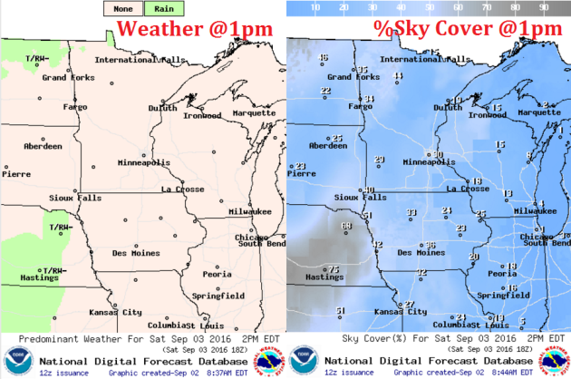
Weather Outlook Saturday
Saturday looks like another beautiful day with highs close to average, low humidity values and plentiful sunshine. There will be a little more cloud cover than what we had over the past few days, but we will stay dry!
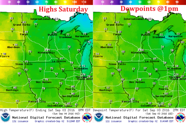
Weather Outlook Saturday
Winds will be a little breezy on Saturday once again with sustained winds in the 10 to 15mph range. Some spots across central and western Minnesota could see wind gusts up to 20 to 25mph through the afternoon.

Weather Outlook Saturday
Again, Saturday looks like another mostly dry day with a few clouds moving in from the Dakotas. If we see any precipitation on Saturday, it would be late and should stay mainly across far western Minnesota.
Simulated Radar
The simulated radar from PM Friday to PM Sunday suggests quiet conditions persisting through much of Saturday, however, it appears that a few spotty showers/storms may start to develop and spread through the regions as we approach the late weekend timeframe.

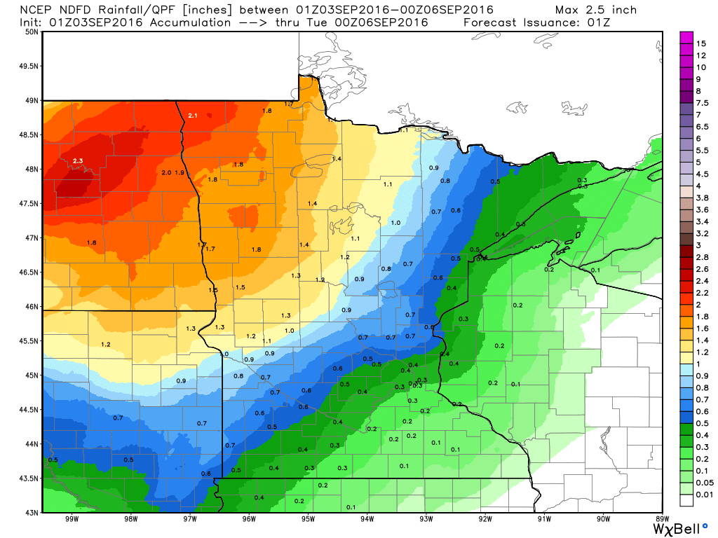
Rainfall Potential
Here's the rainfall potential through PM Monday, which suggests a fairly decent surge of moisture starting to move into the western part of the state by late weekend. Note that rainfall tallies look quite a bit more impressive across the northwestern part of the state with some 1" to 2" amounts possible.
__________________________________________
Thunder Threat Saturday
Thunderstorms will slowly push east over the next few days and slowly our chance of thunder will increase. Our best chance of thunder across the state won't really arrive until late Sunday and into Monday, however, there maybe a few spotty rumbles across the state PM Saturday.
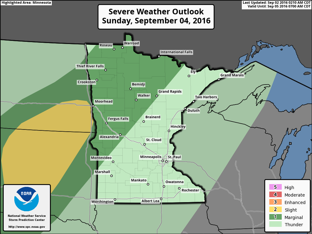
Thunder Threat Sunday
Sunday sees a little better chance of storms late in the day across the eastern part of North and South Dakota, some of which could be a little on the strong to possibly severe side. Whatever develops there could slide into far western Minnesota late Sunday evening.
7 Day Rainfall Outlook
The sunny, dry, comfortable weather as of late certainly has been a treat. Enjoy it while you can because unsettled and wetter weather returns late weekend into next week. According to NOAA's WPC, the 7 day rainfall forecast suggests fairly widespread 1" to 2"+ rainfall through the end of next week.
Extended Weather Outlook
The extended temperature outlook through the first full week of September suggests a bit of a warm up by the end of the weekend and into early next week with muggier dewpoints as well. However, it appears that it won't last too long as readings settle back to near normal levels by the end of the week. We may even be looking at temps below average as we approach mid September.
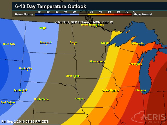
6 to 10 Day Temp Outlook
According to NOAA's CPC, the 6 to 10 day temperature outlook suggests a fairly decent chance of warmer than normal conditions settling in around the Great Lakes Region during the first full week of September. A bigger blob of cooler air will settle in across the Northwestern part of the country, which may drift our way as we approach the 2nd weekend of the month.
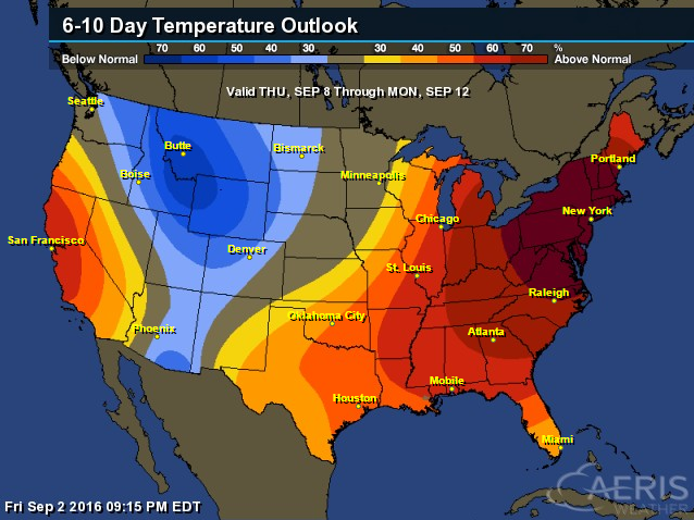
6 to 10 Day Temp Outlook
The national outlook suggests that much of the eastern part of the country will remain above average, however, there will be a fairly significant pocket of below average temps across the central and northern Rockies.
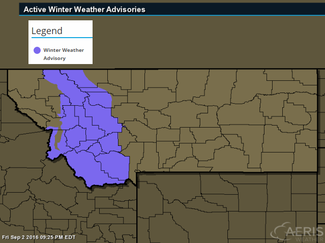
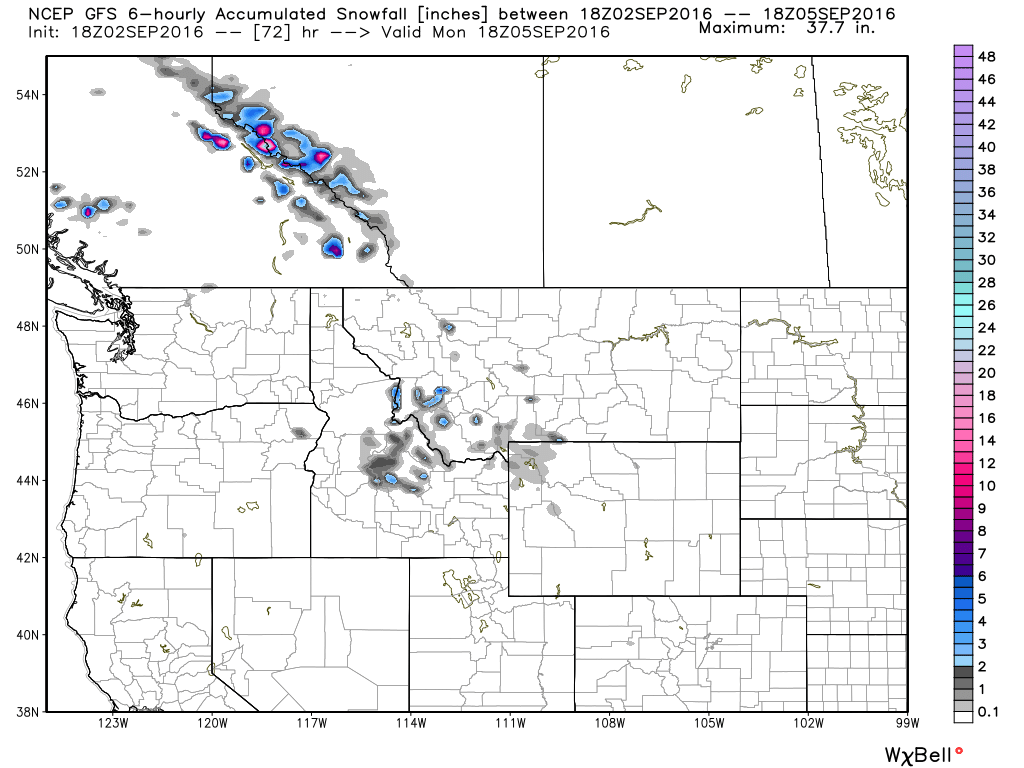
High Elevation Snow?
Take a look at this! The National Weather Service has issued a Winter Weather Advisory for parts of western Montana above 7000ft. for snowfall accumulations that could approach 2" to 5" from Sunday into Monday.
...WINTER WEATHER ADVISORY IN EFFECT FROM NOON SUNDAY TO NOON MDT MONDAY ABOVE 6000 FEET... THE NATIONAL WEATHER SERVICE IN MISSOULA HAS ISSUED A WINTER WEATHER ADVISORY FOR ABOVE 6000 FEET... WHICH IS IN EFFECT FROM NOON SUNDAY TO NOON MDT MONDAY.
* SNOW ACCUMULATIONS:1 TO 2 INCHES AROUND 6000 FEET WITH 2 TO 5 INCHES ABOVE 7000 FEET.
* IMPACTS/TIMING: AN EARLY SEASON STORM WILL DEVELOP SUNDAY MORNING IN SOUTHWESTERN MONTANA AND TRACK NORTH TOWARD CANADA MONDAY AFTERNOON. UNUSUALLY COLD TEMPERATURES WILL PRODUCE SNOW ABOVE 6000 FEET. AREAS OF CONCERN ARE MAINLY BACKCOUNTRY ROADS AND RECREATIONAL AREAS ABOVE 6000 FEET...SUCH AS GEORGETOWN LAKE AND SKALKAHO PASS. CAMPERS...HIKERS...AND HUNTERS SHOULD PLAN FOR RAW AND WINTRY BACKCOUNTRY CONDITIONS IN THESE EFFECTED AREAS STARTING SUNDAY AFTERNOON AND OVERNIGHT INTO MONDAY MORNING. LOST TRAIL PASS COULD SEE LIGHT SNOW ACCUMULATIONS FOR BRIEF PERIODS OF TIME WITH THE HEAVIER PRECIPITATION...THOUGH EXPECTED TO MELT FAIRLY QUICKLY.
___________________________________________
National Weather Outlook
The national weather outlook shows Hermine lifting northeast along the coast, which in turn will have impacts across the rest of the nation. Tropical systems tend to have ripple effects on other weather systems, so things don't move along as quickly as they otherwise would. High pressure will linger a little longer across the Great Lakes and unsettled, wetter weather will linger across the Plains over the next few days as Hermine creates a traffic jam in the East.

Precipitation Outlook
According to NOAA's WPC, the 5 day forecast suggests heavier rain continuing along the Eastern Seaboard as Hermine lifts northeast along the coast. Meanwhile, dry weather persists in the Eastern Great Lakes and Ohio Valley as high pressure dominates. Persistent showers and storms will find themselves through the Intermountain-west and into the Midwest through early next week.
______________________________________
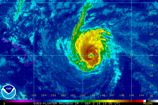
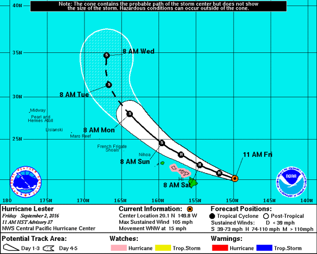
Lester in the Pacific
Here's a view of Hurricane Lester in the Central Pacific Ocean, which will be bearing down on the Hawaiian Islands as we head into the weekend. As of PM Thursday, Lester was a category 3 hurricane with sustained winds of 120mph with a very defined eyewall; see below.

Tracking Lester
According to NOAA's CPHC, Lester will make a very close call with the Hawaiian Islands, but still bring some fairly significant impacts to those areas. Hurricane Watches have been posted for Maui as Lester drifts northwest.
 _________________________
"Pope Francis calls climate change a ‘sin’"
"Pope Francis is imploring Catholics to confess their sins against the environment, calling the degradation of the climate a “sin against God.” In his message marking the World day of Prayer for the Care of Creation on Thursday, the pontiff said climate change is caused in part by human activity, leads to extreme weather and disproportionately affects the least advantaged around the world. “Global warming continues, due in part to human activity: 2015 was the warmest year on record, and 2016 will likely be warmer still,” Francis said. “This is leading to ever more severe droughts, floods, fires and extreme weather events.” “The world’s poor, though least responsible for climate change, are most vulnerable and already suffering its impact,” he said."
"Pope Francis leaves after a vesper prayer in St. Peter's Basilica at the Vatican, Thursday, Sept. 1, 2016. This year, the Sept. 1 day of prayer for the planet falls during Francis' Holy Year of Mercy, a yearlong focus on the church's merciful side. (AP Photo/Alessandra Tarantino)"

___________________________
"California moves to add methane limits to climate agenda"
"SACRAMENTO — California Democrats are taking further steps to advance the state’s ambitious climate-change agenda, agreeing to regulate methane emissions from landfills and dairy farms for the first time and approving $900 million in spending on environmental programs. The approval came in the final hours of the two-year legislative session Wednesday following a flurry of negotiations involving Governor Jerry Brown, Democratic legislative leaders, and the affected industries. It was approved just a week after Democrats voted to extend California’s landmark climate change law, the most aggressive in the nation, by another 10 years through at least 2030. That move, pushed by Brown and environmentalists, came amid fierce opposition from oil companies and other business interests."
________________________________________
Thanks for checking in and have a great end of your week and weekend ahead!
Don't forget to follow me on Twitter @TNelsonWX
Don't forget to follow me on Twitter @TNelsonWX

Did you know that you can create short urls with BCVC and make money from every visit to your shortened links.
ReplyDelete