25th Anniversary of the 1991 Halloween Blizzard
Believe it or not, this is the 25th anniversary of the 1991 Halloween Blizzard. I was 9 that year and dressed up as a cow. It was an incredible storm and vividly remember snow piling up on my snout as I trudged from house to house in search for goodies.

The Minnesota State Climate Office has a wonderful write up regarding the storm, here's an excerpt:
"The Halloween Blizzard of 1991 still stands as a benchmark blizzard in Minnesota that other storms are compared to 25 years later."
"October Blizzards in Minnesota are rare, but they have happened in the past. The most severe early blizzard on record for Minnesota was the devastating October 16, 1880 storm. This storm left behind drifts of snow to 20 feet high in the Canby area and brought train traffic to a standstill over western Minnesota until the spring thaw. This winter is vividly portrayed in Laura Ingalls Wilder's Book: The Long Winter."
"The Halloween Blizzard in 1991 is one of those weather events that people can recall what they were doing as it unfolded. Folks were still celebrating the Minnesota Twins second World Series win in just four years when a cold front ushered in unseasonably cold air. The high temperature in the Twin Cities was 65 degrees on the 29th, over ten degrees above normal. On October 30th, the high temperature in the Twin Cities only reached 32 degrees. By this time a low pressure area was developing around Galveston Texas. From the seasoned veterans at the National Weather Service to students studying meteorology at St. Cloud State, there was no secret that a large storm was coming. Most forecasts for October 31st for central Minnesota called for a cold rain by the afternoon. Possibly heavy. The primary question at the time was: "How much rain would fall?""
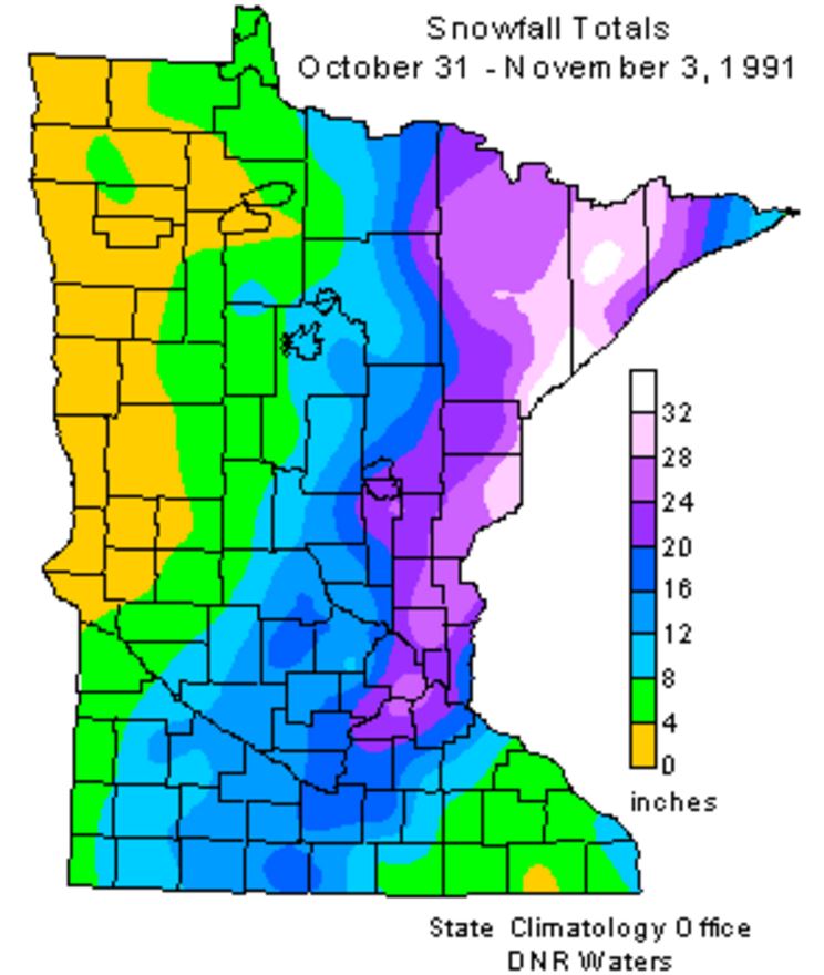
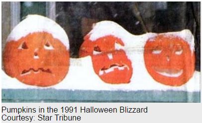
"As Halloween dawned back in 1991, some wintry weather was anticipated but no one was expecting a blizzard. The National Weather Service issued a Winter Storm Watch at 4:00 am on the 31st with a potential of a foot of snow. The first inkling that the forecast under projected snowfall totals came when precipitation started falling as snow at about 11:30am in the Twin Cities, much earlier than anticipated. With the realization that the precipitation would be snow, not rain, a Winter Storm Warning was issued during the day by the National Weather Service in the Twin Cities and forecasters realized there was a potential for a lot of snow. As the afternoon faded into evening a surreal scene unfolded with kids attempting to trick or treat wearing coats and boots and pumpkins becoming covered with a snowy blanket. 8.2 inches of snow fell by midnight on the 31st at the Twin Cities International Airport, the most for the entire month of October on record for the Twin Cities."
See more from the Minnesota State Climatology Office HERE:
"The Halloween Blizzard in 1991 is one of those weather events that people can recall what they were doing as it unfolded. Folks were still celebrating the Minnesota Twins second World Series win in just four years when a cold front ushered in unseasonably cold air. The high temperature in the Twin Cities was 65 degrees on the 29th, over ten degrees above normal. On October 30th, the high temperature in the Twin Cities only reached 32 degrees. By this time a low pressure area was developing around Galveston Texas. From the seasoned veterans at the National Weather Service to students studying meteorology at St. Cloud State, there was no secret that a large storm was coming. Most forecasts for October 31st for central Minnesota called for a cold rain by the afternoon. Possibly heavy. The primary question at the time was: "How much rain would fall?""
"As Halloween dawned back in 1991, some wintry weather was anticipated but no one was expecting a blizzard. The National Weather Service issued a Winter Storm Watch at 4:00 am on the 31st with a potential of a foot of snow. The first inkling that the forecast under projected snowfall totals came when precipitation started falling as snow at about 11:30am in the Twin Cities, much earlier than anticipated. With the realization that the precipitation would be snow, not rain, a Winter Storm Warning was issued during the day by the National Weather Service in the Twin Cities and forecasters realized there was a potential for a lot of snow. As the afternoon faded into evening a surreal scene unfolded with kids attempting to trick or treat wearing coats and boots and pumpkins becoming covered with a snowy blanket. 8.2 inches of snow fell by midnight on the 31st at the Twin Cities International Airport, the most for the entire month of October on record for the Twin Cities."
See more from the Minnesota State Climatology Office HERE:
Halloween Climatology
I know we're still a few days away from Halloween, but the Minnesota State Climatology Office has some good stats regarding Halloween Climatology for the Twin Cities.
"Halloween is typically a time of crunchy leaves on the ground, and a bit of chill in the air. High temperatures in the Twin Cities are generally in the 40's and 50's. It is more common for the daily high on Halloween to be in the 60's than in the 30's. 70's tend to be a bit rare, with only eight Halloween high temperatures being 70 degrees or above. The warmest Halloween on record was 83 degrees in 1950, with the second coldest maximum temperature on record arriving one year later with a high of 30 in 1951. The coldest Halloween maximum temperature was a chilly 26 degrees back in 1873. The last fifteen years have had some balmy Halloween afternoons with a 71 degrees in 2000, and some quite cool ones as well with a 34 in 2002. There hasn't been a Halloween washout since 1997. Measurable precipitation has occurred on Halloween only 26% of the time in the Twin Cities, or 38 times out of 144 years. The most rain recorded was in 1979 with .78 inches. In 1991 .85 inches of precipitation fell, which was snow. In spite of the 1991 Halloween Blizzard, measurable snow on Halloween is about as rare as getting a full sized candy bar in your trick or treat bag. Since 1872 there's been enough snow to measure only six times: .6 in 1884, .2 in 1885, 1.4 in 1932, .4 in 1954, .5 in 1995 and of course 8.2 inches with the Halloween Blizzard of 1991. Thus there has been measurable snow on only 4% of the days."
2016 Halloween Weather Outlook
We're still a few days away, but here's a preview of the 2016 Halloween weather across the Upper Midwest. Note that another storm system will push through the region with most of the light rain shower potential across the northern part of the state. With that said, we will be on the southern side of the storm, which means temperatures will be quite mild through the day, but it will be breezy.
2016 Halloween Temperature Outlook
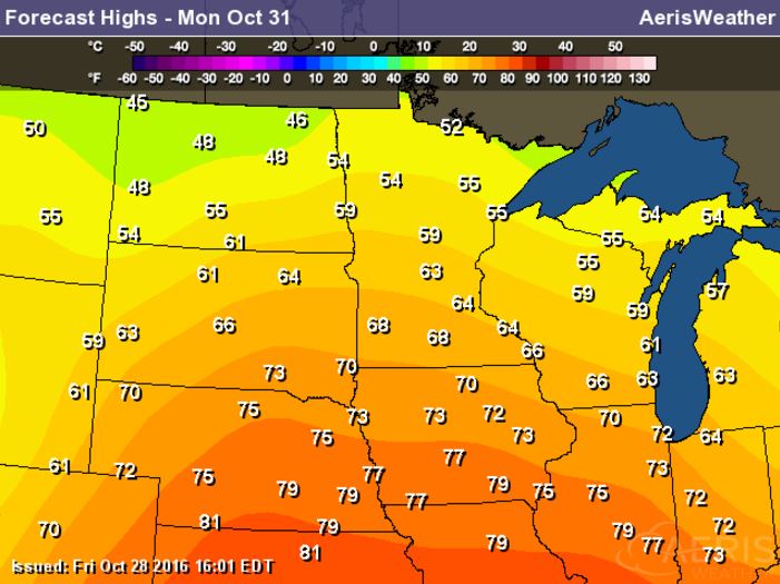
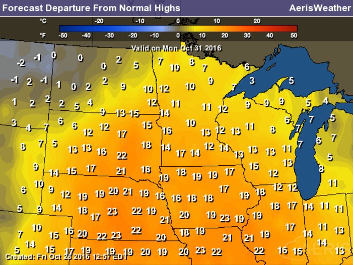
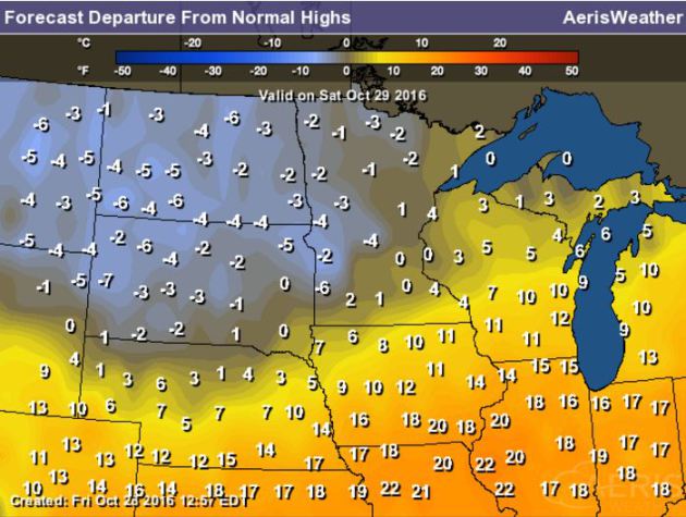
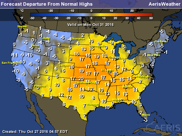
High temperatures on Halloween Monday will be very warm across much of the Upper Midwest with readings nearly 10F to 15F above average.
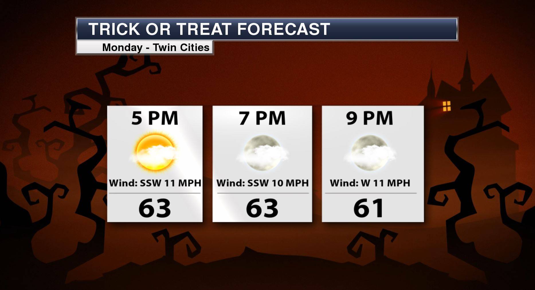
Minneapolis Trick or Treat Forecast
__________________________________________
Fall Color Update
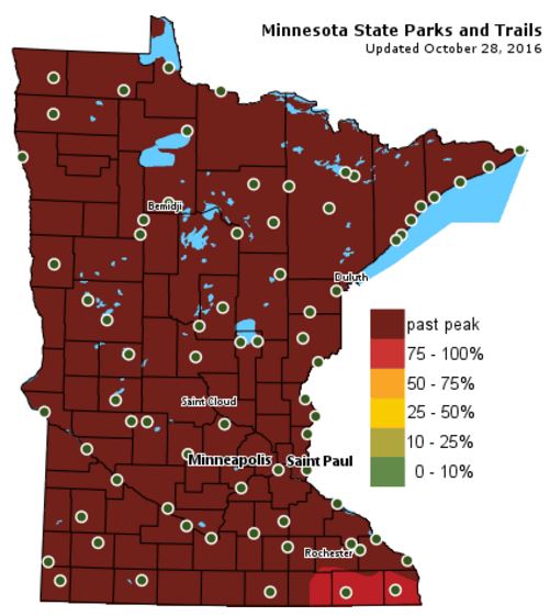
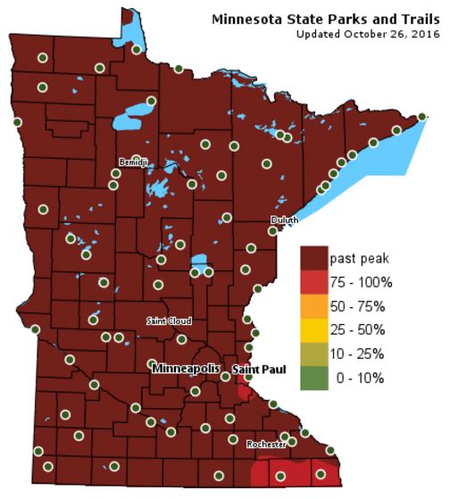
According to the MN DNR, much of the state is now past peak in the fall color department with the exception of a few spots in the extreme southeastern part of the state.
___________________________________________________________________________
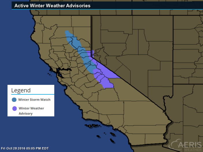
Snow in California! Sierra Nevada Snow...
A LOW PRESSURE SYSTEM WILL DROP SOUTHWARD OUT OF THE GULF OF ALASKA AND THROUGH NORCAL LATE SATURDAY NIGHT AND SUNDAY. THIS COLDER WEATHER SYSTEM WILL DROP SNOW LEVELS DOWN TO NEAR 6000 FEET BY SUNDAY MORNING. THIS WILL BE LOW ENOUGH TO BRING SIGNIFICANT SNOWFALL TO THE MAJOR SIERRA PASSES FOR THE FIRST TIME THIS WINTER SEASON. GUSTY WINDS ARE ALSO LIKELY ON SUNDAY COMPOUNDING THE SIERRA TRAVEL IMPACTS.
* MAIN IMPACTS: SLICK ROADS DUE TO SNOW. UNPREPARED TRAVELERS MAY EXPERIENCE VERY LONG DELAYS. CHAIN RESTRICTIONS PROBABLE.
* OTHER IMPACTS...WINDS GUSTING TO 50 MPH THROUGH THE PASSES COULD CAUSE POOR VISIBILITY AND DIFFICULTY DRIVING.
* TIMING...LATE SATURDAY NIGHT THROUGH SUNDAY EVENING...HEAVIEST SUNDAY AFTERNOON.
* LOCATIONS...SIERRA NEVADA PASSES AND LASSEN PARK ABOVE 6000 FEET.
* SNOW ACCUMULATIONS...6 TO 12 INCHES OVER SIERRA PASSES. 1 TO 2 FEET OF SNOW ABOVE 7000 FEET AND OVER LASSEN PARK.
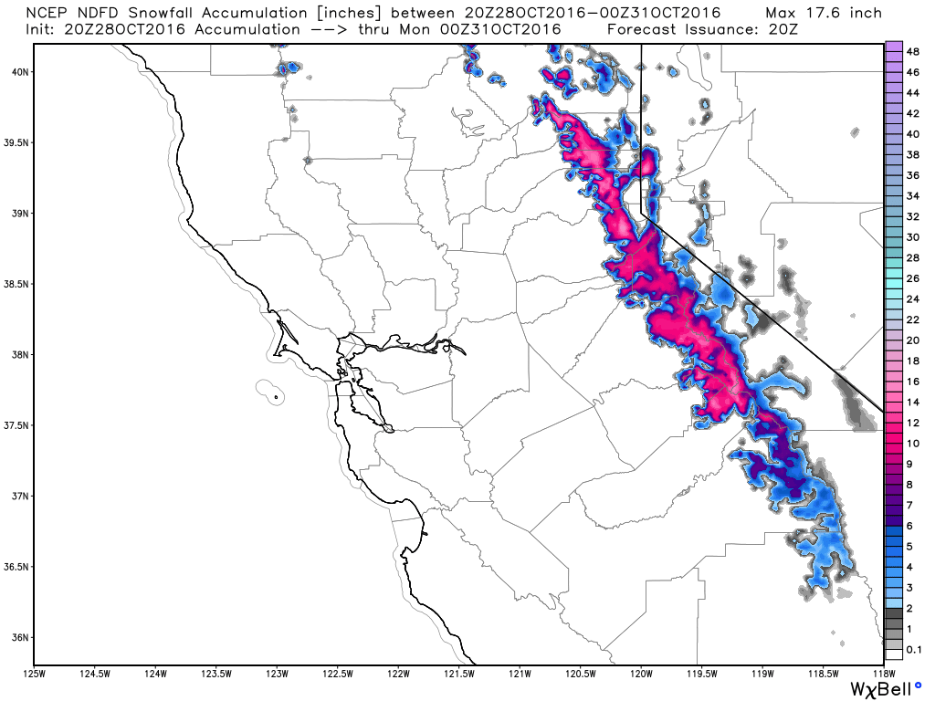
Weekend Snowfall Potential
Here's the snowfall potential through PM Sunday, which suggests some fairly significant amounts across the higher elevations of the Sierra Nevada Range.
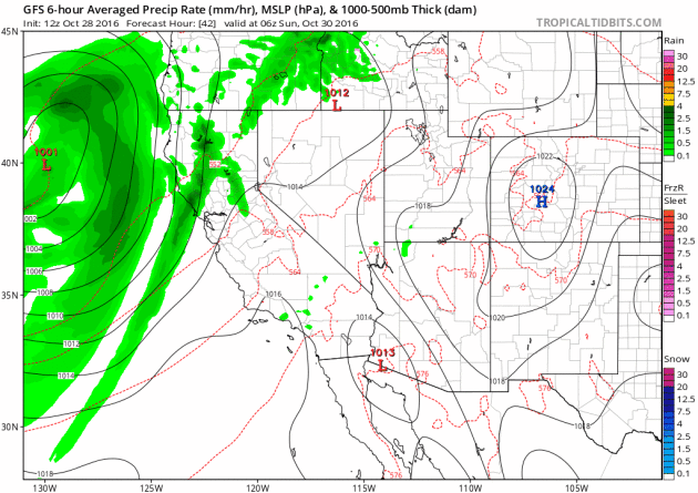
Quick Hitting Storm in the West
Another surge of Pacific moisture is expected to move into the Western U.S. this weekend with heavy rain and high elevation snow. The heaviest precipitation looks to move in late Saturday through Sunday.
A Few Showers PM Saturday. Mild Stretch Continues
I feel like I am being lulled into fall at a very slow pace this year. My urge to prep for the colder months ahead has been delayed by continued warmer than average temps. Warm clothes are still packed away. I don't even know where my snow blower is and I am not sure if I even still own a shovel. I have this nagging suspicion that winter is going to all the sudden just hit. I hope I am wrong.
According to NOAA's Climate Prediction Center, the 8 to 14 day temperature outlook suggests that temperatures will remain warmer than average into the second full week of November. I don't see any major storm systems brewing over the next 5 to 7 days, but a little rain could make for soggier raking duties later today. Sunday looks like the drier, sunnier day of the weekend with highs warming into the mid 50s.
Breezy south winds will allow temps to warm back into the 60s just in time for Halloween. There may be a few light rain showers across northern Minnesota, but we'll stay snow free.
Get ready to turn the clocks back NEXT weekend.
___________________________________________________
Extended Weather Outlook
FRIDAY NIGHT: Partly to mostly cloudy. Winds: WSW 5. Low: 50.
SATURDAY: Cooler. Light PM rain. Winds: N 5-10. High: 55.
SATURDAY NIGHT: Showers early. Winds: NNW 5. Low: 39.
SUNDAY: Chilly start. More afternoon sun. Winds: SSE 5-10. High: 53.
Halloween Monday: Blustery Halloween. Few showers. Winds: SSW 10-20. Wake-up: 44. High: 62.
TUESDAY: Mild start to November. Winds: SSW 5-10. Wake-up: 49. High: 62.
WEDNESDAY: AM sprinkle, PM clearing. Winds: NW 5-15. Wake-up: 47. High: 60.
THURSDAY: Sunny. Warm winds continue. Winds: SSW 10-15. Wake-up: 44. High: 60.
FRIDAY: Few clouds, still dry. Winds; SSW 5-15. Wake-up: 42. High: 59.
_______________________________
_______________________________
This Day in Weather History
October 28th
2004: Exceptionally muggy conditions for October are felt over much of the state. Dew points surged into the middle to upper 60's over central and southern Minnesota. Ladybugs are extremely active.October 28th
1955: Early snow hits the Twin Cities, accumulating to 2.2 inches.
1905: Several inches of snowfall accumulate in south central Minnesota. Snow totals included 7 inches at Fairmont, 6 inches at Farmington, 4.5 inches at Montevideo, 4 inches at Faribault, and 3 inches at New London.
________________________________
Average High/Low for Minneapolis
October 29th
Average High: 52F (Record: 78F set in 1922)
Average Low: 35F (Record: 15F set in 1925)
_________________________________
Average Low: 35F (Record: 15F set in 1925)
_________________________________
Sunrise/Sunset Times for Minneapolis
October 29th
October 29th
Sunrise: 7:48am
Sunset: 6:05pm
Sunset: 6:05pm
*Daylight Lost Since Yesterday: ~2mins & 50sec
*Daylight Lost Since Summer Solstice: ~5hours and 21mins
______________________________________________________________________
*Daylight Lost Since Summer Solstice: ~5hours and 21mins
______________________________________________________________________
Moon Phase for October 28th at Midnight
1.4 Days Before New Moon
1.4 Days Before New Moon

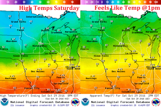
Weather Outlook Saturday
High temperatures on Saturday will be much cooler than what we had on Friday. Note that temperatures will be in the 40s and 50s across the state, which is a little closer to average than our abnormally warm Friday that we had.
High Temperatures From Average Saturday
High temps from average on Saturday will be a little closer to where we should be at this time of the year. Our much warmer than average weather that we had on Friday will move into the Ohio Valley ahead of the passing cold front.
Weather Outlook Saturday
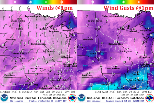
A cool front moving through the Upper Midwest will allow allow winds to switch out of the north and usher in cooler temperatures over the weekend. Winds will be fairly light.
Weather Outlook Saturday
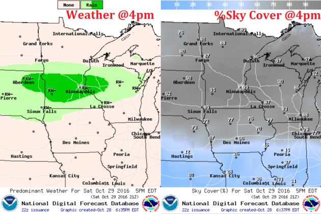
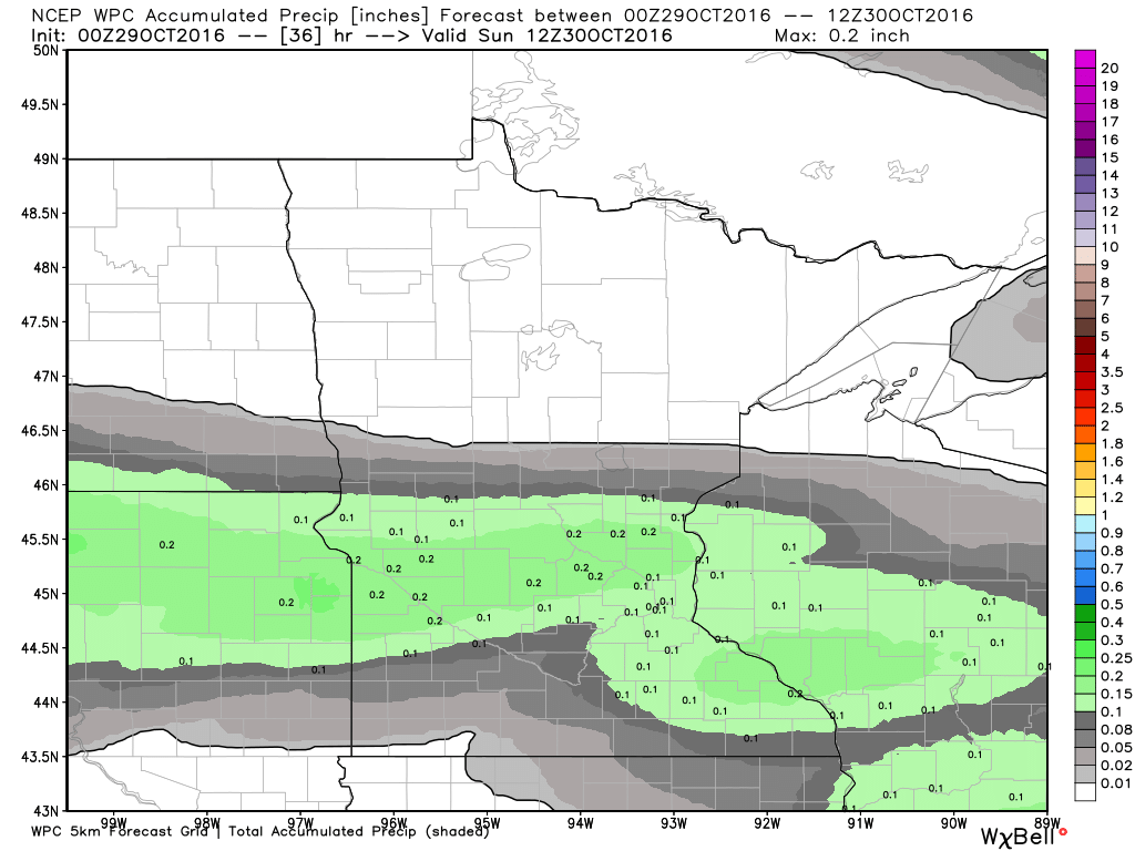
We will start off on a dry note Saturday, but a quick moving system will bring scattered showers to parts of the region late in the day. Here's weather depiction by 4pm Saturday, which shows a batch of rain across the southern half of the state later in the day.
___________________________________________________________
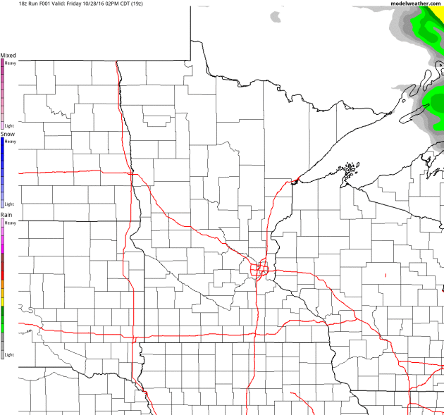
Simulated Radar
Here's the simulated radar from PM Friday to Monday, which shows a chance of light rain showers moving through the southern half of the state PM Saturday.
Rainfall Potential
As our next system moves in from the west on Saturday, light precipitation will be possible across the central and southern part of the state with a few spots seeing up to 0.25" rain.
_______________________________________
Extended Weather Outlook
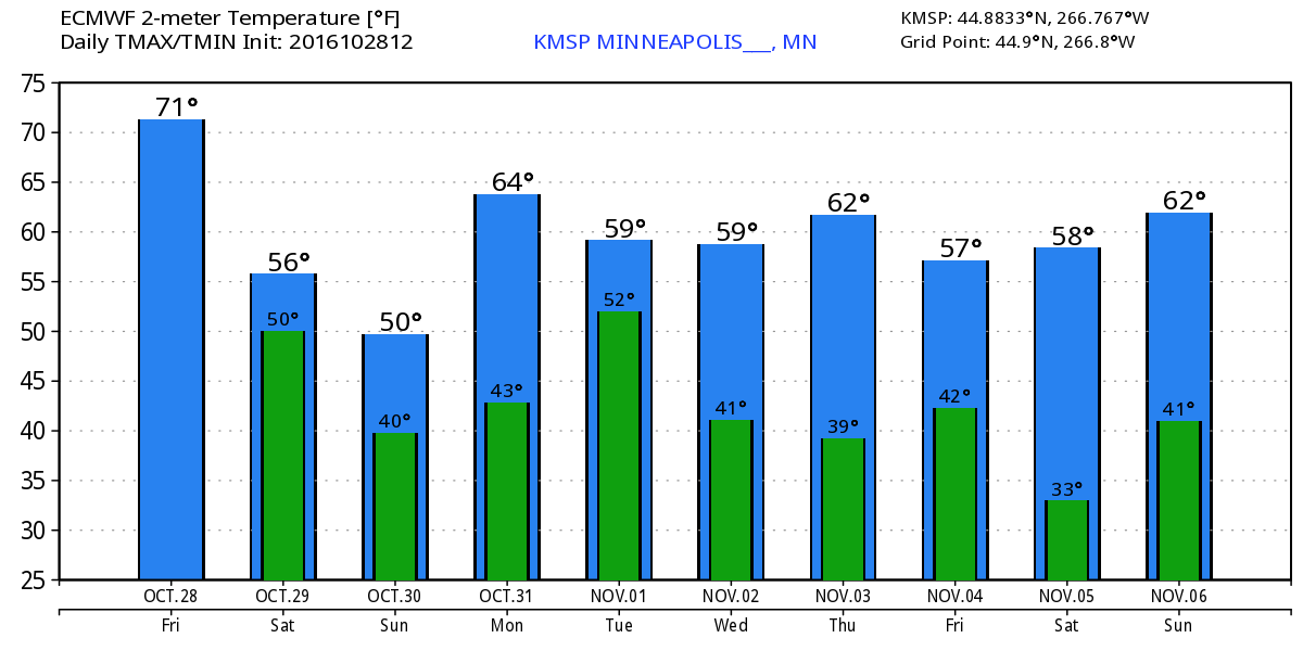
After a very warm Friday, temperatures fall to near normal levels this weekend. Note that through much of next week, we stay well above avearge.
Warm Temperatures Return to Midwest
According to NOAA's CPC, the 6 to 10 day temperature outlook suggests warmer than average temperatures continuing across much of the Upper Midwest as we head through the early part of November.
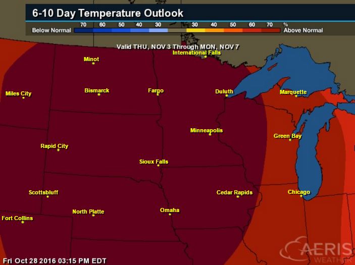
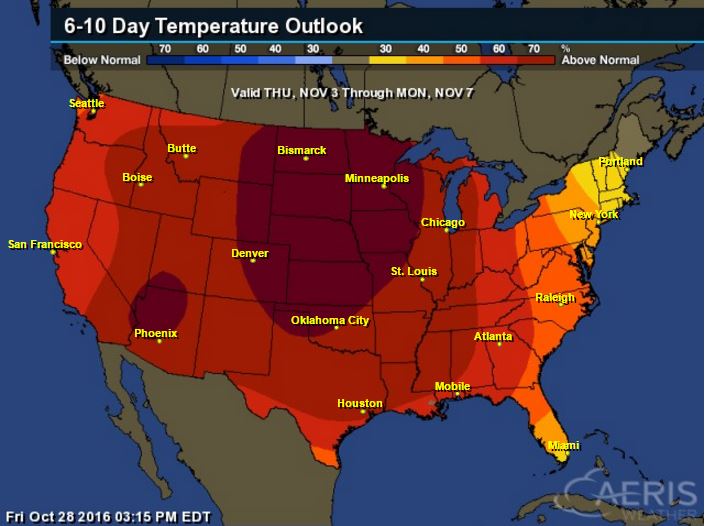
Here's the national temperature outlook from November 3rd - 7th, which shows warmer than average conditions across much of the nation.
__________________________________________
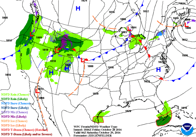
National Weather Outlook
Active weather conditions continue across the Western U.S. with heavy rain along the coast and high elevation snow. Some of the Pacific moisture will make it into the Central US over the coming days.
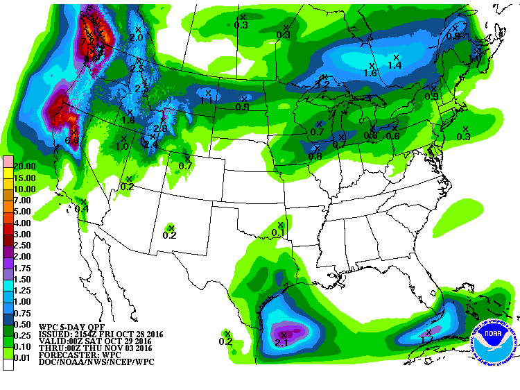
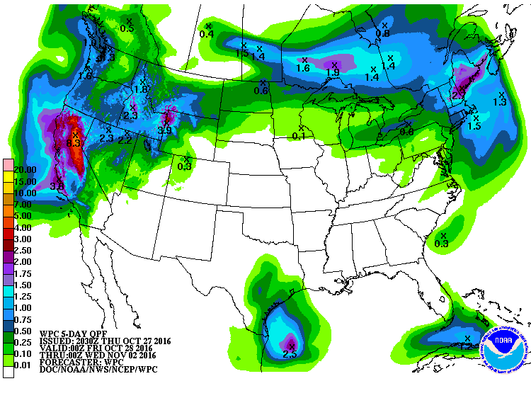
Precipitation Outlook
According to NOAA's WPC, the heaviest precipitation across the nation will be found in the Western U.S., where come 3" to 6"+ amounts can't be ruled out across parts of California. Much of the Central U.S. will remain dry with the exception of those along the northern tier of the nation.
 ____________________________________________________________________
"The Halloween Blizzard of 1991 still stands as a benchmark blizzard in Minnesota that other storms are compared to 25 years later."
"October Blizzards in Minnesota are rare, but they have happened in the past. The most severe early blizzard on record for Minnesota was the devastating October 16, 1880 storm. This storm left behind drifts of snow to 20 feet high in the Canby area and brought train traffic to a standstill over western Minnesota until the spring thaw. This winter is vividly portrayed in Laura Ingalls Wilder's Book: The Long Winter."
"The Halloween Blizzard in 1991 is one of those weather events that people can recall what they were doing as it unfolded. Folks were still celebrating the Minnesota Twins second World Series win in just four years when a cold front ushered in unseasonably cold air. The high temperature in the Twin Cities was 65 degrees on the 29th, over ten degrees above normal. On October 30th, the high temperature in the Twin Cities only reached 32 degrees. By this time a low pressure area was developing around Galveston Texas. From the seasoned veterans at the National Weather Service to students studying meteorology at St. Cloud State, there was no secret that a large storm was coming. Most forecasts for October 31st for central Minnesota called for a cold rain by the afternoon. Possibly heavy. The primary question at the time was: "How much rain would fall?""
"As Halloween dawned back in 1991, some wintry weather was anticipated but no one was expecting a blizzard. The National Weather Service issued a Winter Storm Watch at 4:00 am on the 31st with a potential of a foot of snow. The first inkling that the forecast under projected snowfall totals came when precipitation started falling as snow at about 11:30am in the Twin Cities, much earlier than anticipated. With the realization that the precipitation would be snow, not rain, a Winter Storm Warning was issued during the day by the National Weather Service in the Twin Cities and forecasters realized there was a potential for a lot of snow. As the afternoon faded into evening a surreal scene unfolded with kids attempting to trick or treat wearing coats and boots and pumpkins becoming covered with a snowy blanket. 8.2 inches of snow fell by midnight on the 31st at the Twin Cities International Airport, the most for the entire month of October on record for the Twin Cities."
See more from the Minnesota State Climatology Office HERE:
Halloween Climatology
I know we're still a few days away from Halloween, but the Minnesota State Climatology Office has some good stats regarding Halloween Climatology for the Twin Cities.
"Halloween is typically a time of crunchy leaves on the ground, and a bit of chill in the air. High temperatures in the Twin Cities are generally in the 40's and 50's. It is more common for the daily high on Halloween to be in the 60's than in the 30's. 70's tend to be a bit rare, with only eight Halloween high temperatures being 70 degrees or above. The warmest Halloween on record was 83 degrees in 1950, with the second coldest maximum temperature on record arriving one year later with a high of 30 in 1951. The coldest Halloween maximum temperature was a chilly 26 degrees back in 1873. The last fifteen years have had some balmy Halloween afternoons with a 71 degrees in 2000, and some quite cool ones as well with a 34 in 2002. There hasn't been a Halloween washout since 1997. Measurable precipitation has occurred on Halloween only 26% of the time in the Twin Cities, or 38 times out of 144 years. The most rain recorded was in 1979 with .78 inches. In 1991 .85 inches of precipitation fell, which was snow. In spite of the 1991 Halloween Blizzard, measurable snow on Halloween is about as rare as getting a full sized candy bar in your trick or treat bag. Since 1872 there's been enough snow to measure only six times: .6 in 1884, .2 in 1885, 1.4 in 1932, .4 in 1954, .5 in 1995 and of course 8.2 inches with the Halloween Blizzard of 1991. Thus there has been measurable snow on only 4% of the days."
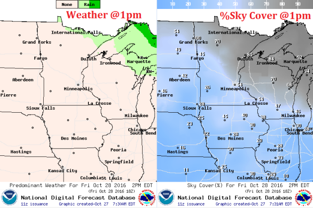
2016 Halloween Weather Outlook
We're still a few days away, but here's a preview of the 2016 Halloween weather. Note that there will be no repeat of the 1991 Halloween Blizzard across the Upper Midwest, but a storm system is expected to be pushing through the Upper Midwest on Monday, October 31st. At this point, blustery winds and scattered light rain showers may be possible as we head through the day.
.gif)
2016 Halloween Weather Outlook
Here's the national weather outlook for Monday, October 31st, which shows scattered rain showers across the northern tier of the nation and parts of the West Coast. There also may be a few snow showers in the high elevations out west. The only place that may see thunder is near the Coastal Bend of Texas.
2016 Halloween Temperature Outlook
High temperatures will be quite a bit warmer than average across much of the nation with highs nearly 10F to 20F above average!
__________________________________________
Fall Color Update
According to the MN DNR, much of the state is now past peak in the fall color department with the exception of a few spots in the extreme southeastern part of the state.
___________________________________________________________________________
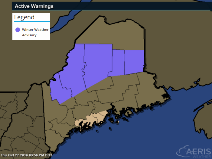
Winter Weather Advisory in Maine
* LOCATIONS...NORTHWEST AND CENTRAL MAINE HIGHLANDS.
* SNOW ACCUMULATIONS...3 TO 6 INCHES...WITH LOCALLY 6 TO 9 INCHES POSSIBLE FOR TERRAIN ABOVE 2500 FT.
* IMPACTS...MODERATE. SNOW WILL RESULT IN DIFFICULT DRIVING CONDITIONS. HEAVY WET SNOW MAY CAUSE TREE BRANCHES TO SNAP WITH ISOLATED TO SCATTERED POWER OUTAGES POSSIBLE.
* WINDS...EAST 10 TO 15 MPH WITH GUSTS UP TO 25 MPH.
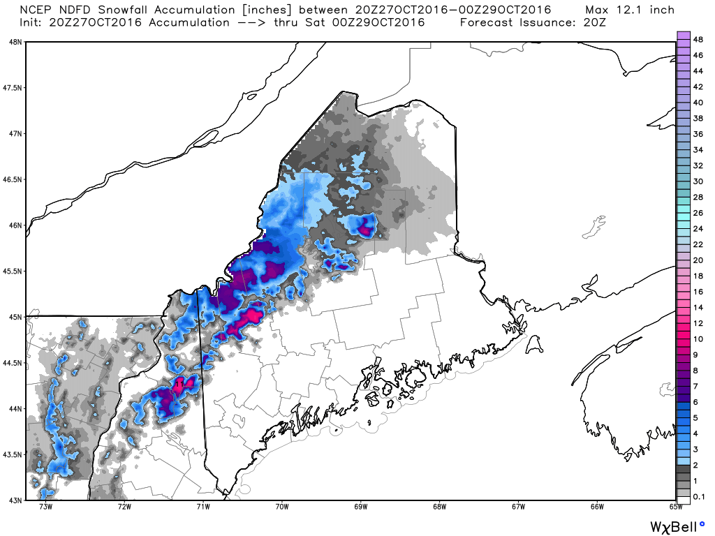
Additional Snowfall
Here's the additional snowfall potential through PM Friday, which suggests some heavier tallies across the high elevations of central and northern Maine.
More Snow in the Northeast
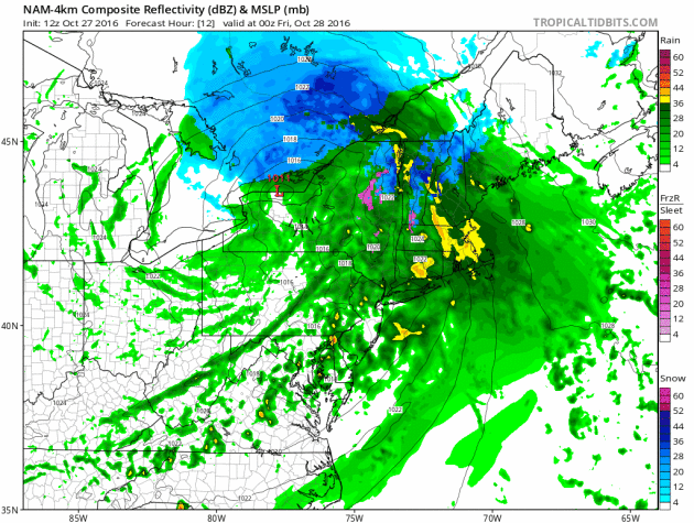
Here's the simulated radar from PM Thursday to AM Saturday in the Northeast, which shows the storm system swirling through the Northern New England States with additional snowfall and scattered rain showers. Note that as that system moves out, another quick moving system moves in, but lighter amounts of precipitation are expected with this one.
A Few Showers PM Saturday. Mild Stretch Continues
I feel like I am being lulled into fall at a very slow pace this year. My urge to prep for the colder months ahead has been delayed by continued warmer than average temps. Warm clothes are still packed away. I don't even know where my snow blower is and I am not sure if I even still own a shovel. I have this nagging suspicion that winter is going to all the sudden just hit. I hope I am wrong.
According to NOAA's Climate Prediction Center, the 8 to 14 day temperature outlook suggests that temperatures will remain warmer than average into the second full week of November. I don't see any major storm systems brewing over the next 5 to 7 days, but a little rain could make for soggier raking duties later today. Sunday looks like the drier, sunnier day of the weekend with highs warming into the mid 50s.
Breezy south winds will allow temps to warm back into the 60s just in time for Halloween. There may be a few light rain showers across northern Minnesota, but we'll stay snow free.
Get ready to turn the clocks back NEXT weekend.
___________________________________________________
Extended Weather Outlook
FRIDAY NIGHT: Partly cloudy. Winds: WNW 5-10. Low: 46.
SATURDAY: Cooler breeze. Light PM rain. Winds: NNE 5-15. High: 55.
SATURDAY NIGHT:
SUNDAY: Chilly start. More afternoon sun. Winds: SE 5-15. Wake-up: 40. High: 56.
Halloween Monday: Blustery Halloween. Few showers. Winds: SSW 10-20. Wake-up: 46. High: 62.
TUESDAY: Clearing with a cooler wind. Winds: W 10-15. Wake-up: 47. High: 55.
WEDNESDAY: Turning nippy. Showers south. Winds: N 10-15. Wake-up: 40. High: 52.
THURSDAY: Chilly sunshine. Winds: NE 5-10. Wake-up: 36. High: 48.
FRIDAY:
_______________________________
_______________________________
This Day in Weather History
October 28th
1960: A 29-day dry stretch in west central Minnesota ends.October 28th
________________________________
Average High/Low for Minneapolis
October 29th
Average High: 52F (Record: 75F set in 1948)
Average Low: 35F (Record: 17F set in 1925)
_________________________________
Average Low: 35F (Record: 17F set in 1925)
_________________________________
Sunrise/Sunset Times for Minneapolis
October 29th
October 29th
Sunrise: 7:46am
Sunset: 6:06pm
Sunset: 6:06pm
*Daylight Lost Since Yesterday: ~2mins & 51sec
*Daylight Lost Since Summer Solstice: ~5hours and 18mins
______________________________________________________________________
*Daylight Lost Since Summer Solstice: ~5hours and 18mins
______________________________________________________________________
Moon Phase for October 28th at Midnight
1.4 Days Before New Moon
1.4 Days Before New Moon
Weather Outlook Saturday
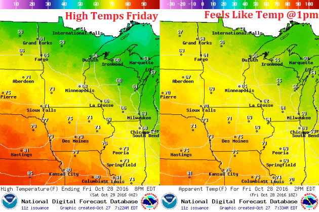
High temperatures on Thursday will be warmer than what we saw on Wednesday, except for locations closer to the Great Lakes. However, note that some 60s will be starting to move into the southwestern part of the state! This is the milder weather that will be moving in by Friday.
High Temperatures From Average Saturday
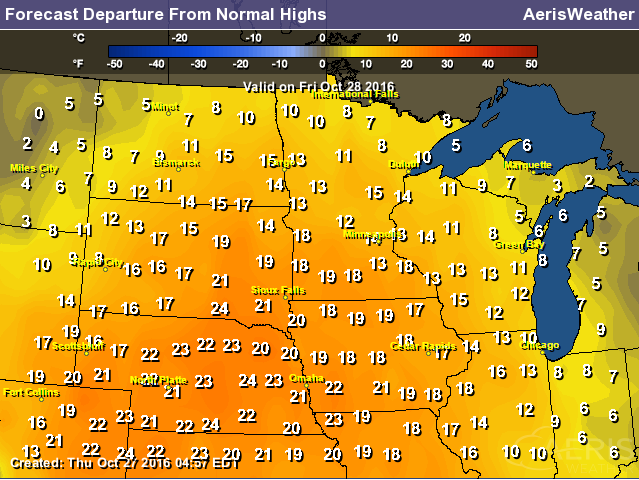
High temps from average on Thursday will start warming to above average levels once again across the western part of the state. This warmer weather will continue streaming into the region through Friday, where much of Friday looks to be 10F to 15F above average!
Weather Outlook Saturday
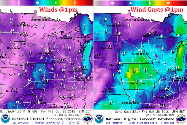
As our midweek soggy storm system pushes east, a southerly wind will start to develop on Thursday, which will help to warm temperatures through the end of the week.
Weather Outlook Saturday
Our wet weather from earlier this week will have subsided, but clouds look to linger into Thursday with much of the state seeing mostly cloudy skies. However, note that parts of western Minnesota will start breaking out into more sun later in the day.
___________________________________________________________
Simulated Radar
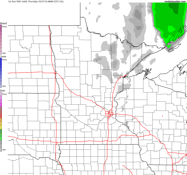
Here's the simulated radar from AM Thursday to PM Saturday, which shows mostly dry conditions across the region until later Saturday when a narrow band of light showers looks to move through the region.
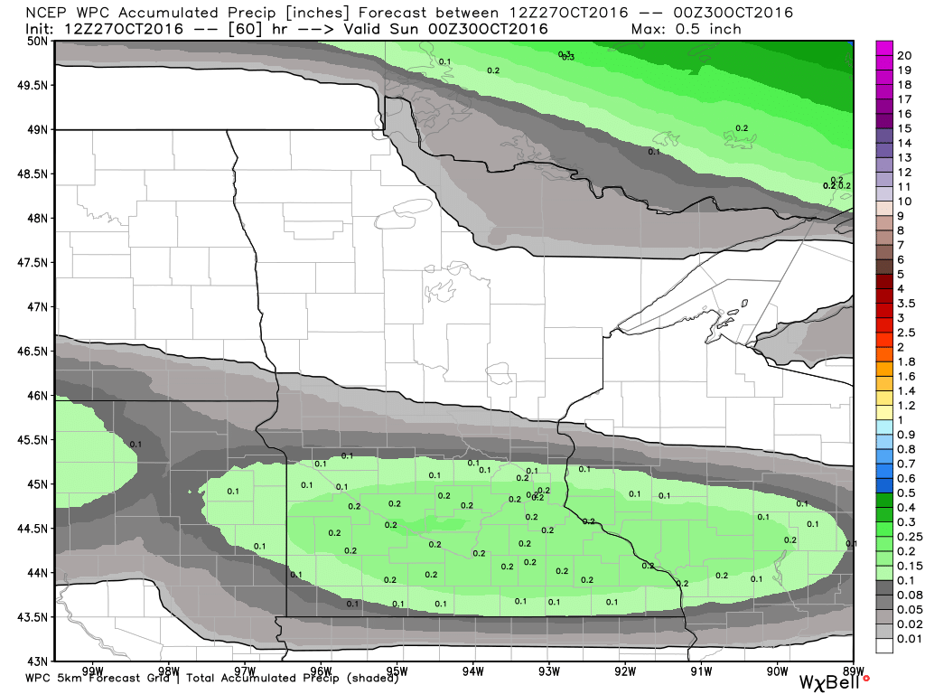
Rainfall Potential
As our next system moves in from the west on Saturday, light precipitation will be possible across the central and southern part of the state with a few spots seeing up to a couple of tenths of an inch of rain.
Warm Friday Ahead
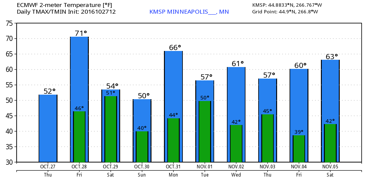
Thanks to a storm system sliding across southern Canada, warm temperatures will be allowed to settle in across the Upper Midwest on Friday. Note that this warm bubble of air looks to be fairly short lived and only with us for one day as cooler air moves in already by Saturday.
________________________________________
Extended Weather Outlook
The extended temperature outlook over the next 10 days shows temperatures warming rather quickly on Friday with highs approaching 70F! This will be a rather brief warm up though as high temperatures slide back down to near average levels this weekend. However, mild temps look to continue on Halloween Monday and through much of next week.
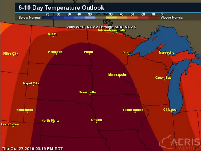
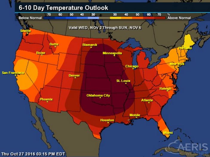
Warm Temperatures Return to Midwest
According to NOAA's CPC, the 6 to 10 day temperature outlook suggests warmer than average temperatures continuing across much of the Upper Midwest as we head into the early part of November.
Here's the national temperature outlook from November 2nd - 6th, which shows warmer than average conditions across much of the nation.
__________________________________________
National Weather Outlook
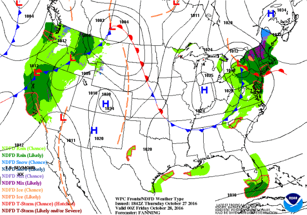
Snowfall and cold rain showers will taper in the Northeast on Friday. Meanwhile, weather conditions in the Western U.S. will remain fairly active with wave after wave of heavy Pacific moisture. Some of this moisture will make its way into the Upper Midwest over the weekend, but it will be much lighter than it is out west.
Precipitation Outlook
According to NOAA's WPC, the heaviest precipitation across the nation will be found in the Western U.S., where come 3" to 6"+ amounts can't be ruled out across parts of California. Much of the Central U.S. will remain dry with the exception of the far north and those in the Northern New England States.
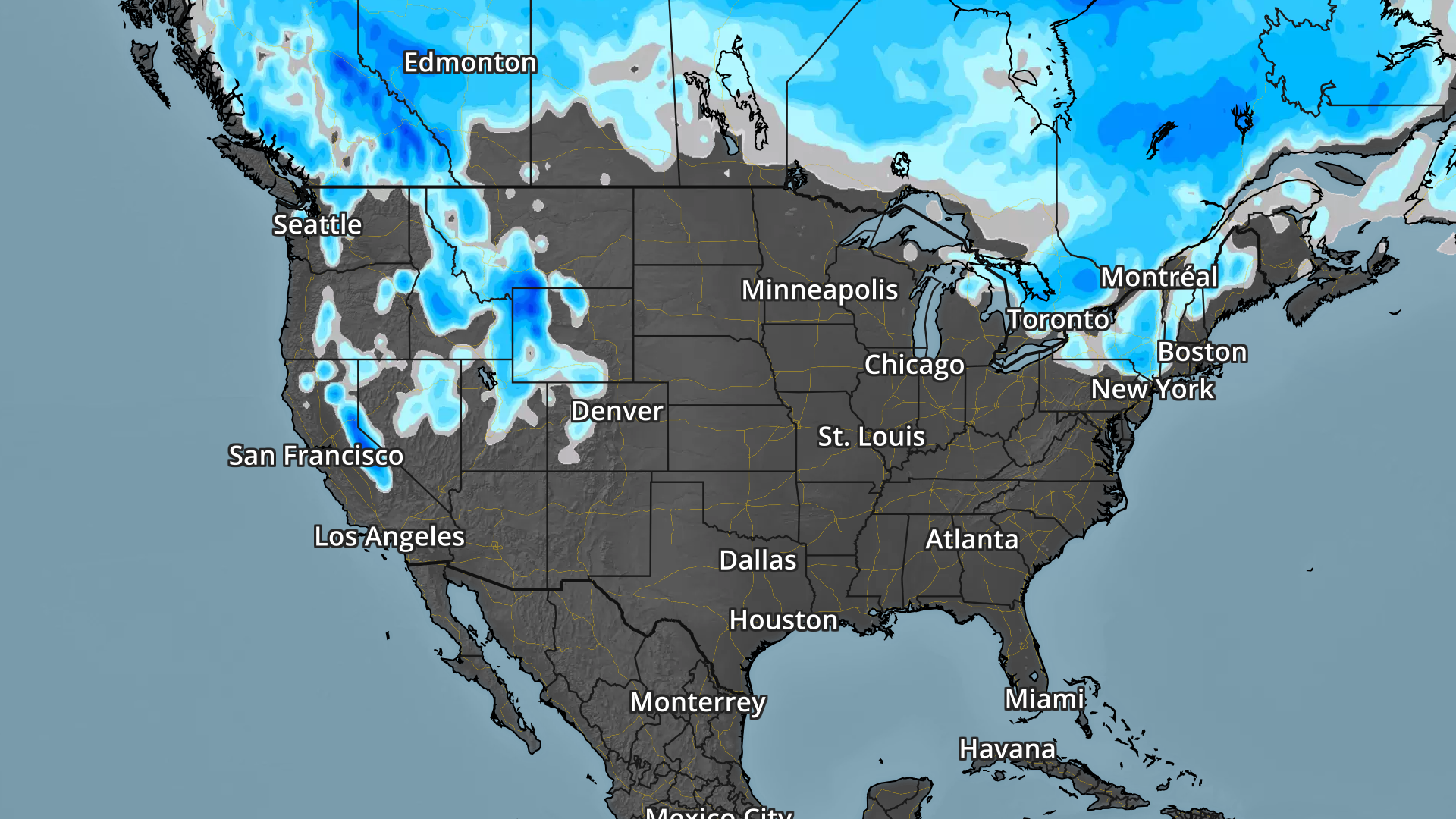
National Snow Potential
Here's a look at the national snowfall potential through early next week, which shows decent snow accumulations possible across parts of the Intermountain West. Note that there may even be snow snow accumulations across the Sierra Nevada Range in California!
 ______________________________________________
____________________________________________________________________
Thanks for checking in and don't forget to follow me on Twitter @TNelsonWX
No comments:
Post a Comment