Recounts from the Memorable Blizzard
Here’s a wonderful mix tape from KFAI’s MinneCulture, which includes interviews from staff members that worked during the blizzard as well as other stories from the massive storm.
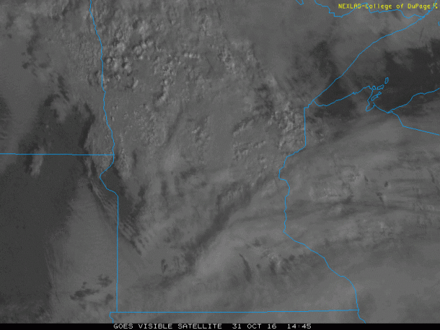
“How can you forget the one Halloween in your life that came with two feet of snow? KFAI’s Britt Aamodt was studying biology at Gustavus Adolphus College when a record snowstorm blasted its way into her life. She wasn’t alone in experiencing the legendary Halloween Blizzard of 1991, a storm that closed schools, shuttered stores and workplaces and left an indelible memory on those that experienced it. (Photo byPeter Boulay)”
LISTEN HERE:

___________________________________________________________________________
 ___________________________________________________________________________
Here’s a wonderful mix tape from KFAI’s MinneCulture, which includes interviews from staff members that worked during the blizzard as well as other stories from the massive storm.
“How can you forget the one Halloween in your life that came with two feet of snow? KFAI’s Britt Aamodt was studying biology at Gustavus Adolphus College when a record snowstorm blasted its way into her life. She wasn’t alone in experiencing the legendary Halloween Blizzard of 1991, a storm that closed schools, shuttered stores and workplaces and left an indelible memory on those that experienced it. (Photo byPeter Boulay)”
LISTEN HERE:
___________________________________________________________________________
Cloudy & Drizzly Monday
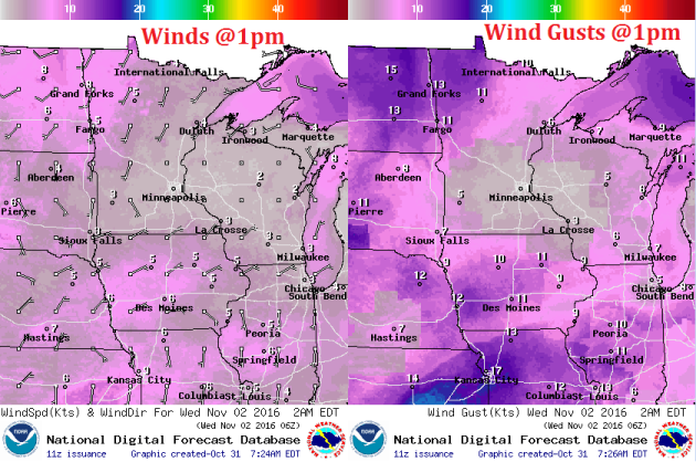
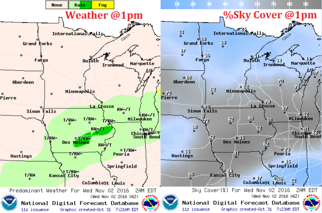
Monday was a pretty dreary day. Not only were the winds blustery, but cloudy skies and areas of drizzle made for a pretty ugly day across the state. However, note how quickly it cleared across the Dakotas and far western Minnesota, this is where some locations warmed into the 70s!
Mostly Quiet Weather Outlook
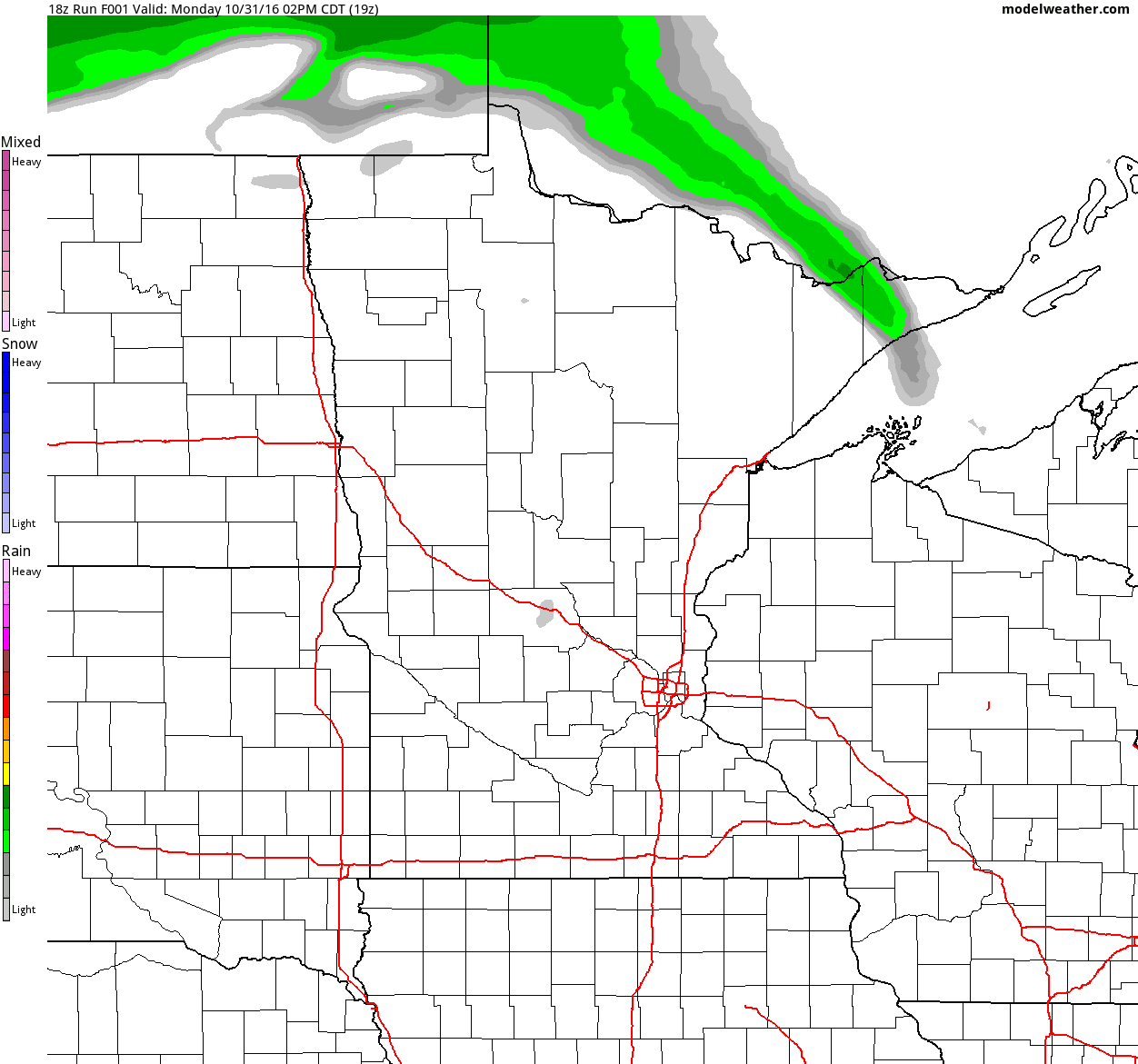
Take a look at the weather from Tuesday to Sunday, which shows mostly quiet weather conditions across Minnesota with only a brief shower chance across the extreme southeastern part of the state on Wednesday.
Imagine waking up to a 2 feet of snow and drifts up to 10 feet high in spots. It happened, 25 year ago on today's date as one of the most significant storms to affect Minnesota continued. 28.4 inches of snow was the grand total in the Twin Cities after "Halloween Blizzard" faded. That record still stands today as the most snow from any single storm in the Twin Cities. Note that 18.5 inches of that fell on November 1st, which is still the snowiest November 1st on record.
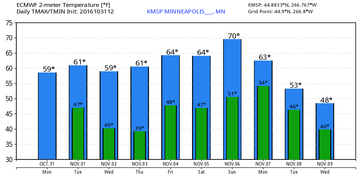
According to Minnesota State Climatologist, Mark Seeley, October will likely go down as one of the 20 warmest on record for the state. The first 10 months of 2016 also ranks as the 4th warmest in history! The Twin Cities has yet to see an official frost and we're nearing record territory again as the latest first 32 degree reading in the Twin Cities was on November 7th, 1900.
The forecast remains mostly dry and mild with temps running nearly 10 to 15 degrees above average through the weekend ahead. Long range models suggest a dip in temps by mid month.
___________________________________________________
Extended Weather Outlook
MONDAY NIGHT: Mostly cloudy with some clearing. Winds: WSW 5-10. Low: 47.
TUESDAY: Sunnier. Warm start to November. Winds: WNW 5-10. High: 60.
TUESDAY NIGHT: Partly cloudy. Winds: W 5. Low: 44.
WEDNESDAY: Filtered sunshine. A few light showers possible in southern MN. Winds: WNW 5-10. High: 62.
THURSDAY: Bright sun, feels more like October. Winds: S 5-10. Wake-up: 43. High: 61.
FRIDAY: Dry and mild, nothing rough. Winds: WNW 5. Wake-up: 45. High: 64.
SATURDAY: Quiet MN Deer Hunting Opener. Winds: S 5-10. Wake-up: 45. High: 62.
SUNDAY: Clouds increase. Few PM showers. Winds: SSE 5-10. Wake-up: 42. High: 62.
MONDAY: More wind. Spotty showers possible. Winds: S 10-20. Wake-up: 45. High: 58.
_______________________________
_______________________________
This Day in Weather History
November 1st
2000: An F1 tornado touches down on a farm east of Prinsburg in Kandiyohi County destroying a small storage shed. It also tipped another shed on its side, and ripped off a portion of the roof of a third shed.November 1st
1999: High winds are reported in central Minnesota. The St. Cloud State University Meteorology Department in Stearns County recorded a 65 mph gust. The Morris AWOS in Stevens County posted a 62 mph gust and the Willmar AWOS in Kandiyohi county recorded a 59 mph gust. Area-wide sustained winds of 40 mph occurred, with gusts in the 45 to 50 mph range.
1991: Classes are canceled across the state due to the Halloween Blizzard. Three foot drifts are measured across I-94 from the Twin Cities to St. Cloud. MSP airport records its all-time record daily snowfall total of 18.5 inches.
________________________________
Average High/Low for Minneapolis
November 1st
Average High: 50F (Record: 77F set in 1933)
Average Low: 34F (Record: 10F set in 1951)
_________________________________
Average Low: 34F (Record: 10F set in 1951)
_________________________________
Sunrise/Sunset Times for Minneapolis
November 1st
November 1st
Sunrise: 7:52am
Sunset: 6:00pm
Sunset: 6:00pm
*Daylight Lost Since Yesterday: ~2mins & 46sec
*Daylight Lost Since Summer Solstice: ~5hours and 29mins
______________________________________________________________________
*Daylight Lost Since Summer Solstice: ~5hours and 29mins
______________________________________________________________________
Moon Phase for October 31st at Midnight
1.6 Days Since New Moon
1.6 Days Since New Moon

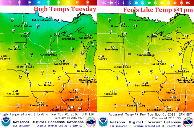
Weather Outlook Tuesday
High temperatures on Tuesday will be fairly mild across the state with the southern half of the state warming into the 60s, while the northern half of the state will warm into the 50s.
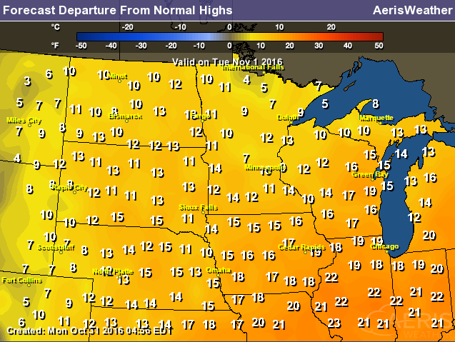
High Temperatures From Average Tuesday
High temps from average on Tuesday will be much above average once again with highs almost 10F to 20F above normal.
Weather Outlook Tuesday
The nice thing about Tuesday is that the winds won't be quite as intense as they were on Monday. Winds will actually be fairly light as our storm system moves away.
Weather Outlook Tuesday
Here's the weather outlook for Tuesday, which shows cloudier skies and areas of light rain across the southeastern tip of Minnesota.
___________________________________________________________
Simulated Radar
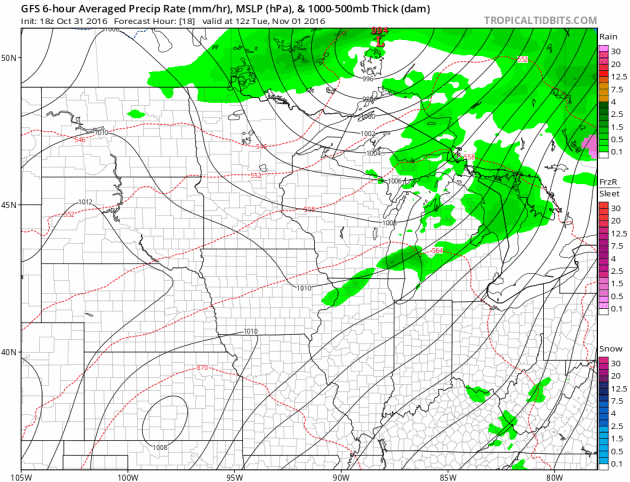
The simulated radar from Tuesday to Thursday shows a little light rain and or drizzle across the northern part of the state, but most will stay dry.
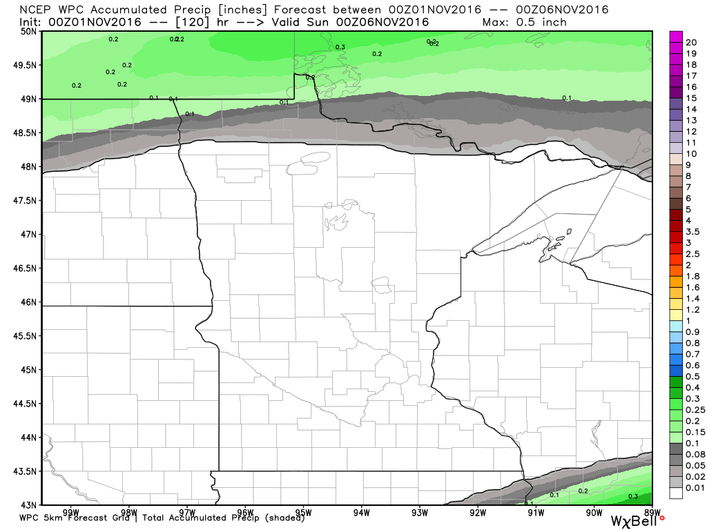
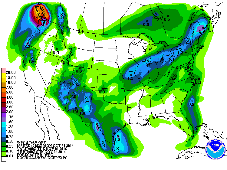
Rainfall Potential
Here's the 5 day rainfall forecast through Saturday, which mostly dry conditions across the state with the exception of those along the international border.
_______________________________________
Extended Weather Outlook
Temperatures for the rest the week ahead look very mild with temps consistently in the 50s and 60s, which will be well above average.
Warm Temperatures Return to Midwest
According to NOAA's CPC, the 6 to 10 day temperature outlook suggests warmer than average temperatures continuing across much of the Upper Midwest as we head through the early part of November.
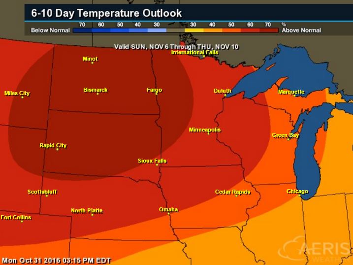
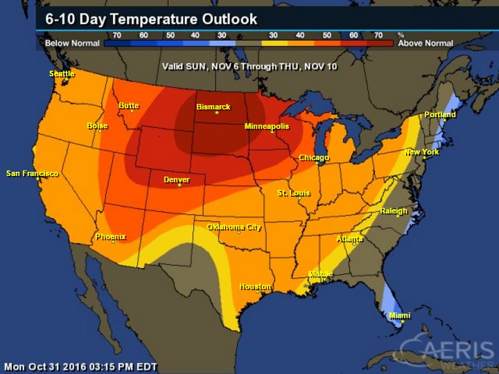
Here's the national temperature outlook from November 6th - 10th, which shows warmer than average conditions across much of the nation.
__________________________________________
National Weather Outlook
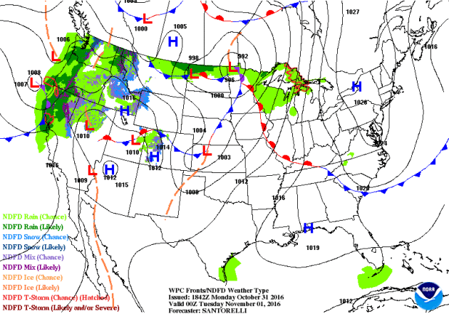
Active weather conditions continue across the Western U.S. will begin to fade a little, but moisture will start to push into the Central US by midweek.
Precipitation Outlook
According to NOAA's WPC, the heavy Pacific moisture along the West Coast will begin to ease up, but there still may be some heavy tallies across the extreme northwestern part of the Pacific Northwest. There also seems to be a little more moisture moving in along the Southern Plains to the Great Lakes and the Northeast.
 _____________________________________________________________________________
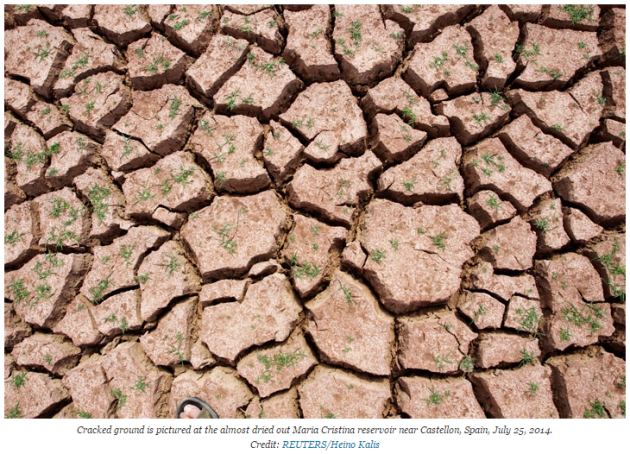
"Global warming is on track to disrupt the Mediterranean region more than any droughts or heatwaves in the past 10,000 years, turning parts of southern Europe into desert by the end of the century, scientists said. Average temperatures in the region have already risen by 1.3 degrees Celsius (2.3 Fahrenheit) since the late 19th century, well above the world average of 0.85°C (1.5°F), according to the study led by France's Aix-Marseille University. Man-made climate change "will likely alter ecosystems in the Mediterranean in a way that is without precedent" in the past 10,000 years unless governments quickly reduce greenhouse gas emissions, the researchers wrote in the journal Science. With unchecked warming, deserts would expand in southern Spain and Portugal, northern parts of Morocco, Algeria and Tunisia and other regions including Sicily, southern Turkey and parts of Syria, it showed. And it would dramatically shift vegetation in the region, famed for umbrella pines, olive groves, and holm oaks. Last year, almost 200 governments agreed in Paris to limit the rise in average world surface temperatures to "well below" 2°C above pre-industrial times, ideally 1.5°C. Governments will meet in Morocco next month to review the accord. Only the 1.5°C global goal would ensure Mediterranean ecosystems stay within bounds of the past 10,000 years, the study said. Debate about cutting emissions "is urgent for such sensitive regions," lead author Joel Guiot of Aix-Marseille University told Reuters. The Mediterranean is sensitive to global warming partly because Atlantic storms are likely to shift northwards, meaning more sun and less rain."
See more from ClimateCentral HERE:
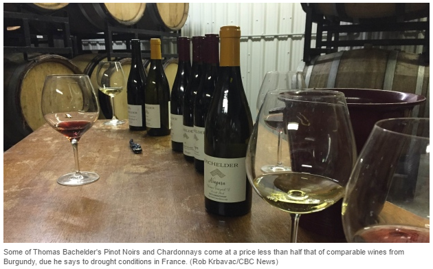
"The weather in the summer of 2015 was unlike anything Chile's Aurelio Montes Jr. had experienced in nearly 30 years of winemaking. "We never get rain during summer, but last year we had some rains during summer...very extreme rains, tropical rains, that's not very common in Chile." said Montes, who has vineyards in Curico and Colchagua, Chile, producing Cabernet Sauvignon, Merlot, Chardonnay, and Sauvignon Blanc. Experts are predicting a drop in global production of wine because of climate change, which is forcing up prices, particularly of Old World wines. That has Canadian winemakers seeing an opportunity. The rain in Chile was a result of El Nino, a cyclical climate event where surface waters in parts of the Pacific become warmer than average resulting in unusual weather systems in different parts of the world. The effect of climate change on wine The El Nino of 2015-16 was among the worst in the last 30 years. In South America, it produced monsoon-like rains causing widespread flooding and extensive damage. Meanwhile, in France, extreme spring storms and a late frost damaged plants in traditional winemaking regions in 2016 and a drought has cut production in recent years."
See more from CBCNews HERE:
Thanks for checking in and don't forget to follow me on Twitter @TNelsonWX

No comments:
Post a Comment