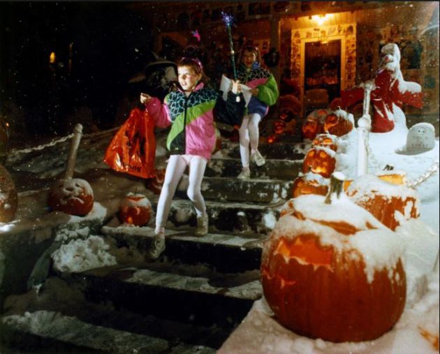
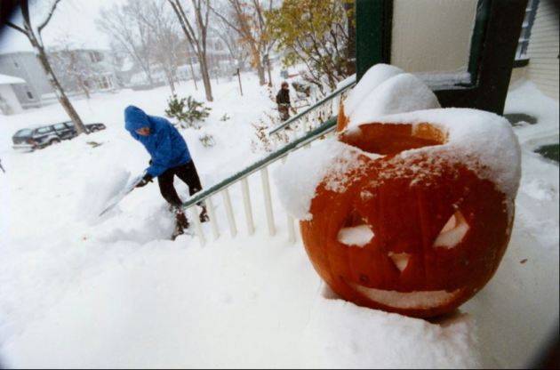
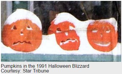
"25 Photos That Perfectly Capture the Halloween Blizzard of 1991"
Here are some great pictures taken during the 1991 Halloween Blizzard
See more pictures HERE:
(Image credit: Brian Peterson via StarTribune)
 (Image credit: Rick Sennot via StarTribune)
 Recounts from the Memorable Blizzard
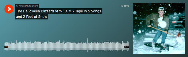
Here’s a wonderful mix tape from KFAI’s MinneCulture, which includes interviews from staff members that worked during the blizzard as well as other stories from the massive storm.
“How can you forget the one Halloween in your life that came with two feet of snow? KFAI’s Britt Aamodt was studying biology at Gustavus Adolphus College when a record snowstorm blasted its way into her life. She wasn’t alone in experiencing the legendary Halloween Blizzard of 1991, a storm that closed schools, shuttered stores and workplaces and left an indelible memory on those that experienced it. (Photo byPeter Boulay)”
LISTEN HERE:

Here are some great pictures taken during the 1991 Halloween Blizzard
See more pictures HERE:
(Image credit: Brian Peterson via StarTribune)
Here’s a wonderful mix tape from KFAI’s MinneCulture, which includes interviews from staff members that worked during the blizzard as well as other stories from the massive storm.
“How can you forget the one Halloween in your life that came with two feet of snow? KFAI’s Britt Aamodt was studying biology at Gustavus Adolphus College when a record snowstorm blasted its way into her life. She wasn’t alone in experiencing the legendary Halloween Blizzard of 1991, a storm that closed schools, shuttered stores and workplaces and left an indelible memory on those that experienced it. (Photo byPeter Boulay)”
LISTEN HERE:
I
was 9 that year and dressed up as a cow. It was an incredible storm and
vividly remember snow piling up on my snout as I trudged from house to
house in search for goodies.
_______________________________________________________________
25th Anniversary of the 1991 Halloween Blizzard
Mark Seely has a good write up in last week's "Weather Talk" about the 1991 Halloween Blizzard.
For
many Minnesota citizens the Halloween Blizzard of 1991 (Oct 31 to Nov
3) remains one of the most dramatic weather events of their lifetime.
One of the largest, most intense, and longest lasting blizzards to ever
hit the state, this storm paralyzed many sections of eastern Minnesota
where roads and highways were closed, and also left over 100,000
customers without power due to power lines brought down by ice, which
was up to 2 inches thick in some parts of southeastern Minnesota.
-Over
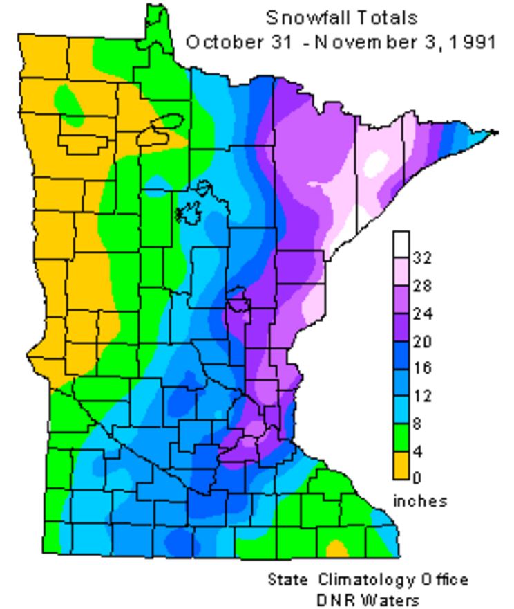
200 new daily snowfall records were set across the state during this
storm, including four communities that reported over 20 inches in a
24-hr period.
-The 4-day blizzard left many areas of the state with record levels of snow depth for November, ranging from 25 to 35 inches.
-At the height of the blizzard snow accumulation was occurring at the rate of 3 inches/hour, with maximum wind gusts to 50 mph.
-At least 16 communities reported a storm total snowfall of 25 inches or greater, topped by 36.9 inches at Duluth.
-In the aftermath of the storm over 100 communities reported sub zero F low temperatures over the first few days of November.
-With such a snowy start to November, many places reported record snowfall for the month, including 46.9" at MSP, 50.1" at Duluth, 51.5" at Two Harbors, and 58.6" at Bruno
Here's another great writeup from The Minnesota State Climate Office about the storm, here's an excerpt:
"The
Halloween Blizzard of 1991 still stands as a benchmark blizzard in
Minnesota that other storms are compared to 25 years later."
"October
Blizzards in Minnesota are rare, but they have happened in the past.
The most severe early blizzard on record for Minnesota was the
devastating October 16, 1880 storm. This storm left behind drifts of
snow to 20 feet high in the Canby area and brought train traffic to a
standstill over western Minnesota until the spring thaw. This winter is
vividly portrayed in Laura Ingalls Wilder's Book: The Long Winter."
"The Halloween Blizzard in 1991 is one of those weather events that people can recall what they were doing as it unfolded. Folks were still celebrating the Minnesota Twins second World Series win in just four years when a cold front ushered in unseasonably cold air. The high temperature in the Twin Cities was 65 degrees on the 29th, over ten degrees above normal. On October 30th, the high temperature in the Twin Cities only reached 32 degrees. By this time a low pressure area was developing around Galveston Texas. From the seasoned veterans at the National Weather Service to students studying meteorology at St. Cloud State, there was no secret that a large storm was coming. Most forecasts for October 31st for central Minnesota called for a cold rain by the afternoon. Possibly heavy. The primary question at the time was: "How much rain would fall?""
"As Halloween dawned back in 1991, some wintry weather was anticipated but no one was expecting a blizzard. The National Weather Service issued a Winter Storm Watch at 4:00 am on the 31st with a potential of a foot of snow. The first inkling that the forecast under projected snowfall totals came when precipitation started falling as snow at about 11:30am in the Twin Cities, much earlier than anticipated. With the realization that the precipitation would be snow, not rain, a Winter Storm Warning was issued during the day by the National Weather Service in the Twin Cities and forecasters realized there was a potential for a lot of snow. As the afternoon faded into evening a surreal scene unfolded with kids attempting to trick or treat wearing coats and boots and pumpkins becoming covered with a snowy blanket. 8.2 inches of snow fell by midnight on the 31st at the Twin Cities International Airport, the most for the entire month of October on record for the Twin Cities."
See more from the Minnesota State Climatology Office HERE:
_________________________________________________________
Halloween Climatology
What is a typical Halloween like in the Twin Cities? Here are a few stats in case you're interested.
"Halloween
is typically a time of crunchy leaves on the ground, and a bit of chill
in the air. High temperatures in the Twin Cities are generally in the
40's and 50's. It is more common for the daily high on Halloween to be
in the 60's than in the 30's. 70's tend to be a bit rare, with only
eight Halloween high temperatures being 70 degrees or above. The warmest
Halloween on record was 83 degrees in 1950, with the second coldest
maximum temperature on record arriving one year later with a high of 30
in 1951. The coldest Halloween maximum temperature was a chilly 26
degrees back in 1873. The last fifteen years have had some balmy
Halloween afternoons with a 71 degrees in 2000, and some quite cool ones
as well with a 34 in 2002. There hasn't been a Halloween washout since
1997. Measurable precipitation has occurred on Halloween only
26% of the time in the Twin Cities, or 38 times out of 144 years. The
most rain recorded was in 1979 with .78 inches. In 1991 .85 inches of
precipitation fell, which was snow. In spite of the 1991 Halloween
Blizzard, measurable snow on Halloween is about as rare as getting a
full sized candy bar in your trick or treat bag. Since 1872 there's been
enough snow to measure only six times: .6 in 1884, .2 in 1885, 1.4 in
1932, .4 in 1954, .5 in 1995 and of course 8.2 inches with the Halloween
Blizzard of 1991. Thus there has been measurable snow on only 4% of the
days."
_______________________________________________________
2016 Halloween Weather Outlook
Here's
a preview of the 2016 Halloween weather across the Upper Midwest. Note
that another storm system will push through the region with light rain
shower potential across parts of the state. With that said, we will be
on the southern side of the storm, which means temperatures will be
quite mild through the day, but it will be breezy.
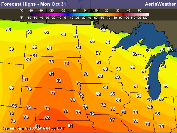
2016 Halloween Temperature Outlook
High
temperatures on Halloween Monday will be very warm across much of the
Upper Midwest with readings nearly 10F to 15F above average.
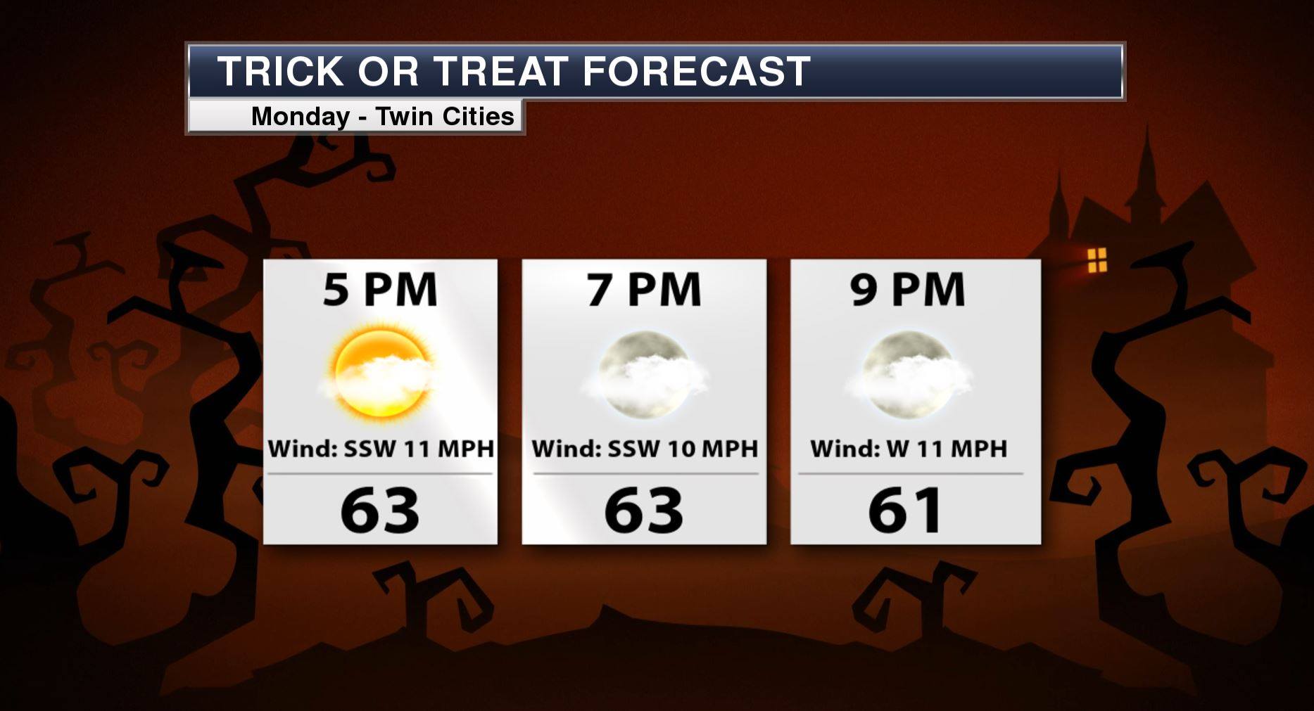
Minneapolis Trick or Treat Forecast
__________________________________________
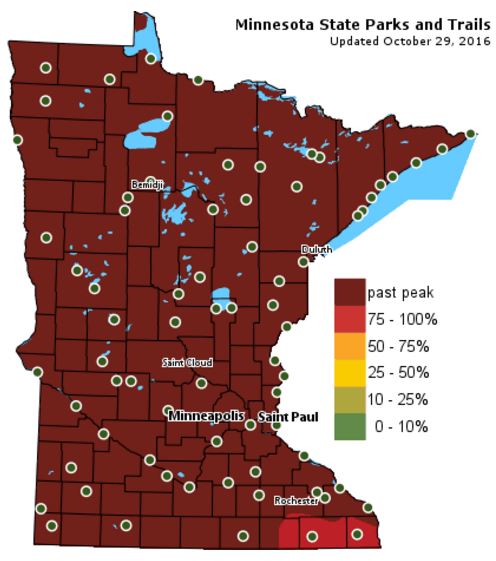
Fall Color Update
According
to the MN DNR, much of the state is now past peak in the fall color
department with the exception of a few spots in the extreme southeastern
part of the state.

___________________________________________________________________________
Today is the 25th Anniversary of the 1991 Halloween Blizzard. Don't laugh, but I was a cow that year. I vividly remember snow piling up on my snout as I slipped from house to house. Few trick or treaters that year meant a full candy bag. Pretty sure I am still nursing a cavity from that Halloween, sorry Dr. Colbert.
No blizzards, not even a flake this year. However, a storm system scooting across the northern part of the state will kick up a blustery south wind that will send temps into the 60s. I could see a few sprinkles later today, but the majority of the light rain concerns will be confined to the international border.
The strong upper level winds look to bubble north into Canada through the week ahead, which will help to keep dry and mild weather in place for a several day period. The next 5 to 7 days look dry with high temps in the low to mid 60s, reminiscent of October.
No concerns for the MN Deer Hunting Opener this weekend. Look for sunshine with temps still riding above average.
The forecast is in autopilot.
___________________________________________________
Extended Weather Outlook
SUNDAY NIGHT: Cloudy. Winds: SSE 5-10. Low: 42.
Halloween Monday: Breezy & mild. PM sprinkle? Winds: S 15-25. High: 61.
MONDAY NIGHT: Mostly cloudy with some clearing. Winds: WSW 10. Low: 47.
TUESDAY: Sunnier. Warm start to November. Winds: WSW 5. High: 64.
WEDNESDAY: Few clouds. Still mild. Winds: WNW 5. Wake-up: 46. High: 61.
THURSDAY: Bright sun, nothing rough. Winds: SW 5-10. Wake-up: 44. High: 60.
FRIDAY: Lull in the weather pattern. Winds: NW 5-10. Wake-up: 42. High: 62.
SATURDAY: Quiet MN Deer Hunting Opener. Winds: SW 5-10. Wake-up: 42. High: 62.
SUNDAY: Mostly sunny. Feels like October. Winds: SSE 5-10. Wake-up: 42. High: 60.
_______________________________
_______________________________
This Day in Weather History
October 31st
October 31st
1991:
The Great Halloween Blizzard begins. Trick or Treating was memorable
for the few who ventured out. 8.2 inches of snow fell at MSP airport by
midnight, with much more to come the following day.
________________________________
Average High/Low for Minneapolis________________________________
October 31st
Average High: 51F (Record: 83F set in 1950)
Average Low: 34F (Record: 14F set in 1878)
_________________________________
Average Low: 34F (Record: 14F set in 1878)
_________________________________
Sunrise/Sunset Times for Minneapolis
October 31st
October 31st
Sunrise: 7:50am
Sunset: 6:02pm
Sunset: 6:02pm
*Daylight Lost Since Yesterday: ~2mins & 48sec
*Daylight Lost Since Summer Solstice: ~5hours and 26mins
______________________________________________________________________
*Daylight Lost Since Summer Solstice: ~5hours and 26mins
______________________________________________________________________
Moon Phase for October 30th at Midnight
0.6 Days Since New Moon
0.6 Days Since New Moon

Weather Outlook Halloween Monday
High
temperatures on Monday will be very mild once again. Note that some
locations across the western and southern part of the state will warm
into the 60s with 50s across the northern half of the state.
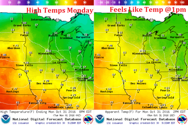
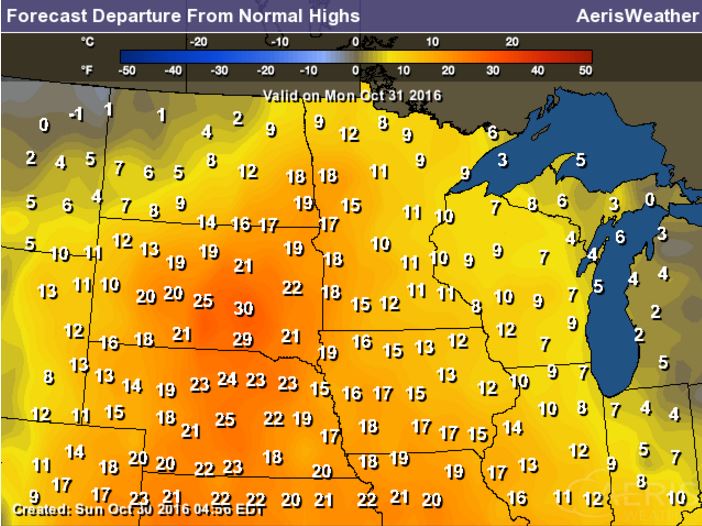
High Temperatures From Average Monday
High
temps from average on Monday will be VERY warm across the state and the
Upper Midwest. Note that some locations over central South Dakota could
be near 30F above average!

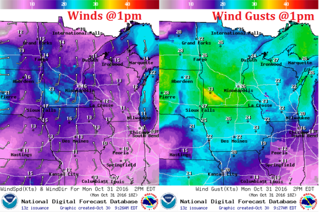
Weather Outlook Halloween Monday
Winds
on Monday will be very breezy across the state as a storm system tracks
across the international border. Sustained winds will be in the 10mph -
20mph range with some gusts approaching 30mph.
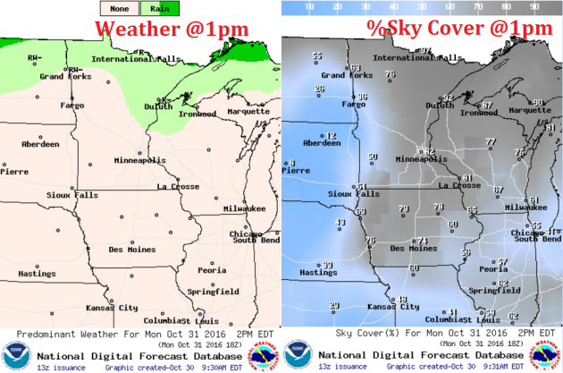
Weather Outlook Halloween Monday
Here's
the weather outlook for Monday, which shows more clouds and light rain
chances sliding through the region. While most of us will see more cloud
cover, the best chance of rain will be found in northern Minnesota.
___________________________________________________________
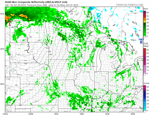
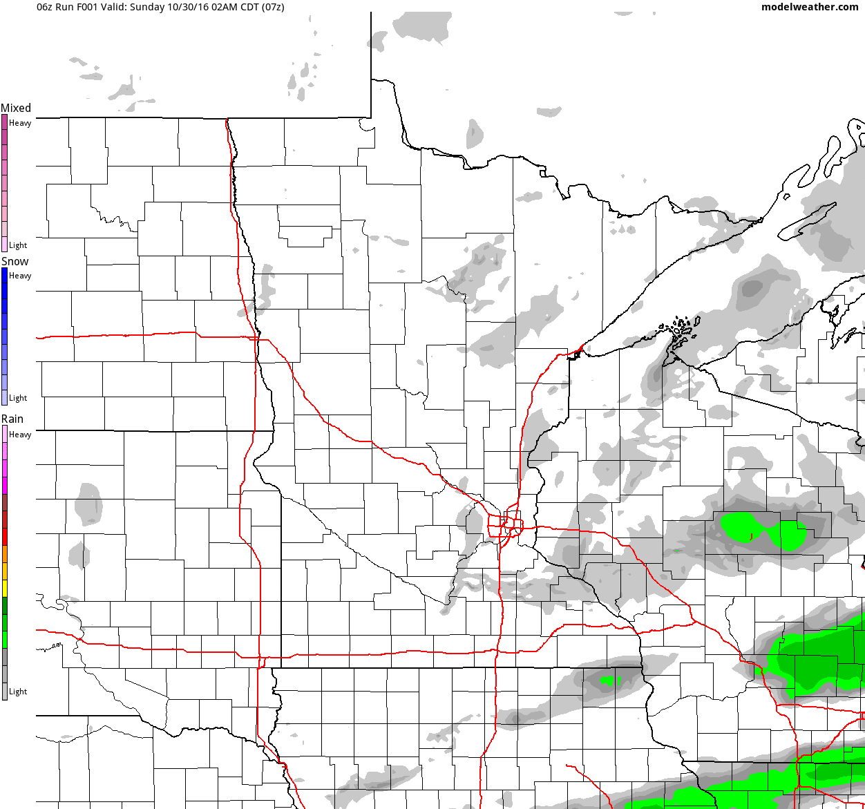
Simulated Radar
The
simulated radar from Sunday to Tuesday shows a quiet Sunday giving way
to a few light showers across the region on Halloween Monday.
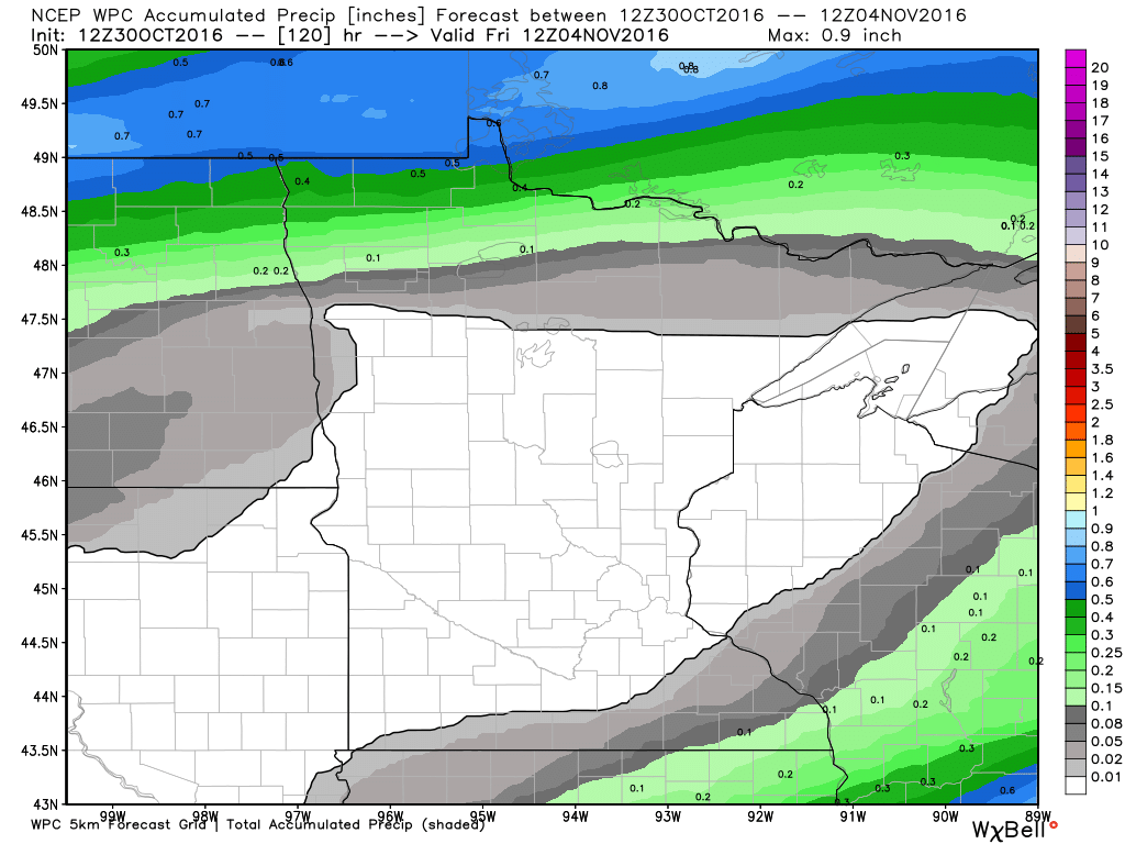
Rainfall Potential
Here's
the 5 day rainfall forecast through the end of the week, which suggests
that much of the state will remain dry. A storm system moving through
the region on Monday could bring a band of light rain across parts of
the state, but the majority will be found along the international
border.
_______________________________________
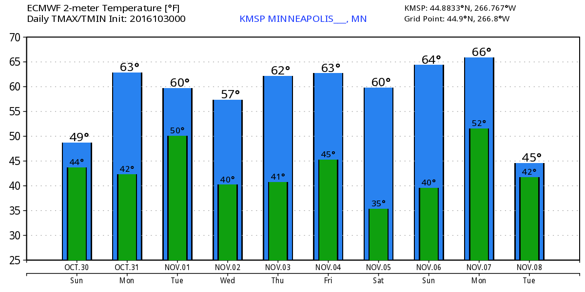
Extended Weather Outlook
Temperatures
for the rest of the weekend will remain at or slightly below average,
but looking at the extended temperature forecast, much of next week will
be warmer than average and more like early October.
Warm Temperatures Return to Midwest
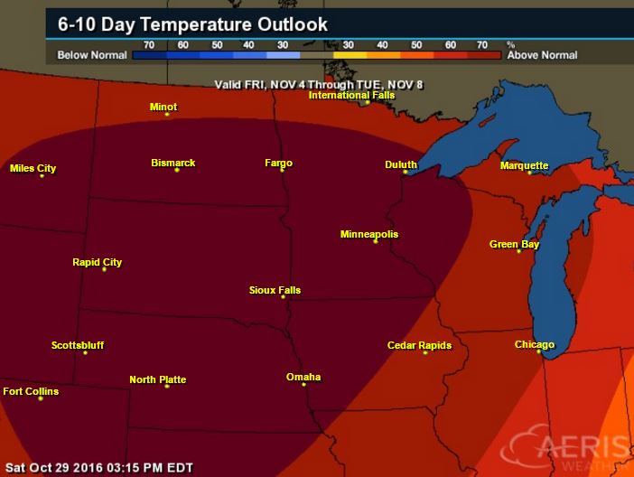
According
to NOAA's CPC, the 6 to 10 day temperature outlook suggests warmer than
average temperatures continuing across much of the Upper Midwest as we
head through the early part of November.
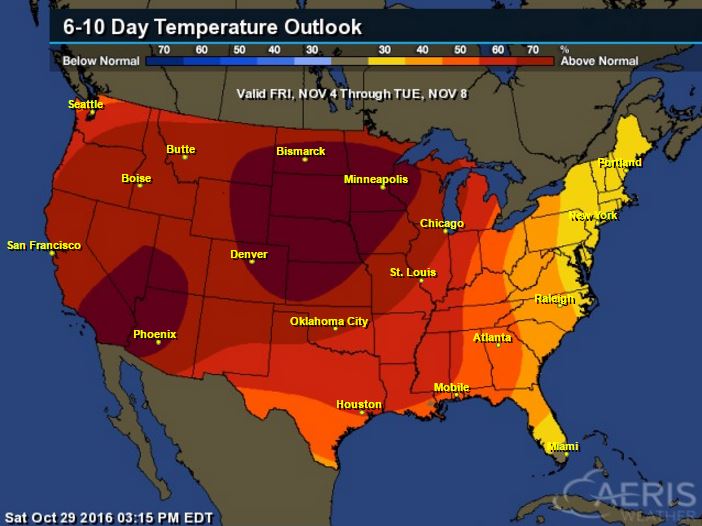
Here's
the national temperature outlook from November 4th - 8th, which shows
warmer than average conditions across much of the nation.
__________________________________________
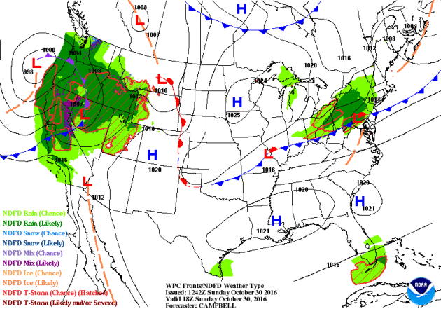
National Weather Outlook
Active
weather conditions continue across the Western U.S. with heavy rain
along the coast and high elevation snow. Some of the Pacific moisture
will make it into the Central US over the coming days.
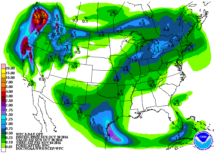
Precipitation Outlook
According
to NOAA's WPC, the heaviest precipitation across the nation will be
found in the Western U.S., where come 3" to 6"+ amounts can't be ruled
out across parts of California. It appears that some moisture will now
start to work into the Central US from the Gulf of Mexico, however
amounts don't look terribly heavy.
 ____________________________________________________________________
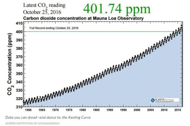
"LISTEN: 58 years of climate change in one minute"
"Climate change is a gradual process, driven by invisible pollution. So it can be hard to wrap your brain around. But atmospheric scientists at the University of Washington have made it possible to listen to the planet changing. You
may never have heard of the Keeling Curve, though it touches the lives
of everyone on earth. It traces how much carbon dioxide is in the sky. Scientists
have been watching it curve upward since the 1950s, when Scripps
geochemist Charles Keeling started his measurements atop Mauna Loa, high
above Hawaii's Big Island, in the middle of the Pacific Ocean. The Keeling Curve has become one of the most widely used indicators of humans' impact on the planet."
See more from Kuow.org HERE:
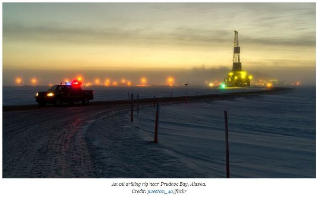
___________________________________________________________________________"New Oil Discoveries Largely Unaffected by Paris Pact"
"Large
crude oil discoveries in 2016 face uncertain prospects of development
for many reasons, but climate change isn’t one of them, at least for the
moment. Climate policies that help countries meet their obligations
under the Paris Agreement are likely to have little effect on newly
discovered oil fields because the Paris pact all but ignores crude oil
consumption and production, experts say. The fate of new oil discoveries
hinges mainly on volatile crude oil markets, the availability of oil in
existing fields and evolving electric vehicle technology. Energy
companies in the U.S. have announced major crude oil discoveries that
could significantly contribute to greenhouse gas pollution even as U.S.
carbon-cutting policies like the Clean Power Plan are contested in
court. Apache Corp. announced in September that it has discovered 3
billion barrels of oil in West Texas and Caelus Energy said in
October that it found 6 billion barrels of crude beneath the Arctic
Ocean off of Alaska’s North Slope. If all of the oil in those
discoveries is consumed, its carbon dioxide emissions may be roughly
equivalent to 70 percent of the U.S.’s total annual carbon dioxide
pollution, according to U.S. Department of Energy data. Every billion
barrels of oil that are consumed emit roughly the equivalent of about 8
percent of U.S. annual carbon emissions, Energy Information
Administration analyst Perry Lindstrom said."See more from Kuow.org HERE:
___________________________________________________________________________"New Oil Discoveries Largely Unaffected by Paris Pact"
See more from Climate Central HERE:
Thanks for checking in and don't forget to follow me on Twitter @TNelsonWX

No comments:
Post a Comment