Hurricane Matthew - The Threat is Real
After battering Haiti, eastern Cuba and parts of the Bahamas with hurricane force winds and exceptional rainfall, Matthew is now on track to impact the Southeastern Friday and through the weekend. Latest forecasts have Matthew sustaining Major hurricane status (category 3 or higher) as it slides along the east coast of Florida on Friday and early Saturday morning. This could be a worst case scenario as intense winds will continue to batter much of the I-95 corridor and for miles on either side of it. Take a look at some of the strong wording the National Weather Service used in advance of Hurricane Matthew hitting:
"EXTREMELY DANGEROUS, LIFE-THREATENING WEATHER CONDITIONS EXPECTED"
"WIDESPREAD EXTENSIVE TO DEVASTATING WIND IMPACTS WILL BE FELT. AIRBORNE DEBRIS LOFTED BY EXTREME WINDS WILL BE CAPABLE OF BREACHING STRUCTURES, UNPROTECTED WINDOWS AND VEHICLES. EFFECTS SUCH AS THESE RANGING FROM THE COAST TO WELL INLAND HAVE NOT BEEN EXPERIENCED IN CENTRAL FLORIDA IN DECADES."
"LOCAL WINDS WILL EXCEED WHAT OCCURRED DURING THE HURRICANES OF 2004. ANY EVACUATIONS AND STRUCTURE PREPARATION SHOULD BE COMPLETED THIS AFTERNOON. TRAVEL WILL BE STRONGLY DISCOURAGED BEGINNING AT DUSK. EXPECT WIDESPREAD POWER OUTAGES."
"STRUCTURAL DAMAGE TO STURDY BUILDINGS, SOME WITH COMPLETE ROOF AND WALL FAILURES. COMPLETE DESTRUCTION OF MOBILE HOMES. DAMAGE GREATLY ACCENTUATED BY LARGE AIRBORNE PROJECTILES. LOCATIONS MAY BE UNINHABITABLE FOR WEEKS OR MONTHS."
"LARGE AREAS OF DEEP INUNDATION WITH STORM SURGE FLOODING ACCENTUATED BY BATTERING WAVES. STRUCTURAL DAMAGE TO BUILDINGS, WITH SEVERAL WASHING AWAY. DAMAGE COMPOUNDED BY FLOATING DEBRIS. LOCATIONS MAY BE UNINHABITABLE FOR AN EXTENDED PERIOD."
.gif)
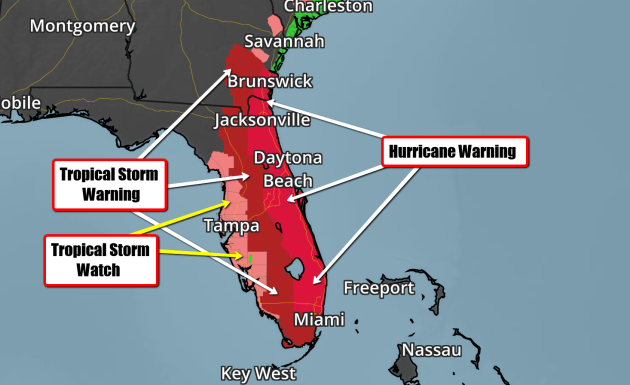
Florida Bracing for Matthew
Hurricane Watches and Warnings have been posted for parts of Florida and Georgia in advance of Matthew as it continues to slowly drift northwest toward the Peninsula. Latest forecast tracks take this along the east coast of Florida later this week/weekend ahead with significant impacts. Mandatory evacuations have already been order for parts of the state as Matthew threatens.
 Hurricane Matthew
 Tracking Matthew
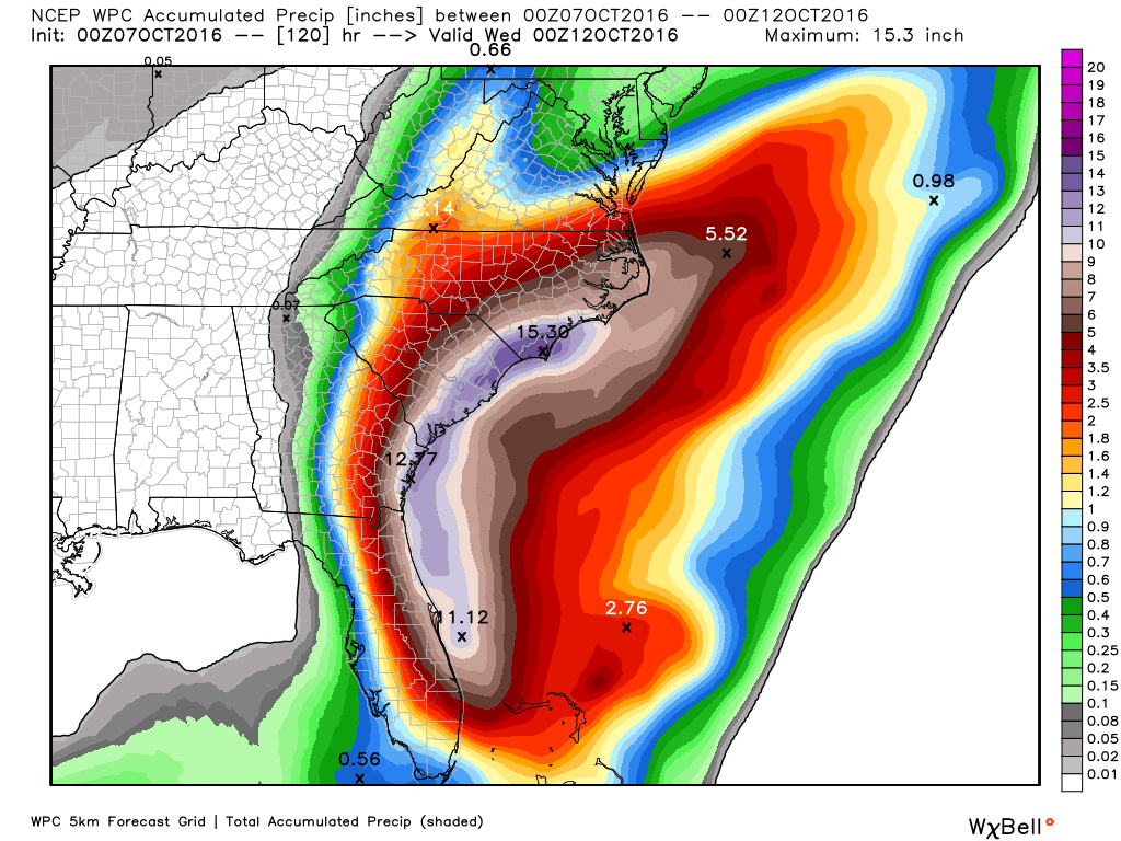
 Heavy Rainfall Potential
_________________________________________________
Rare October Hurricane?
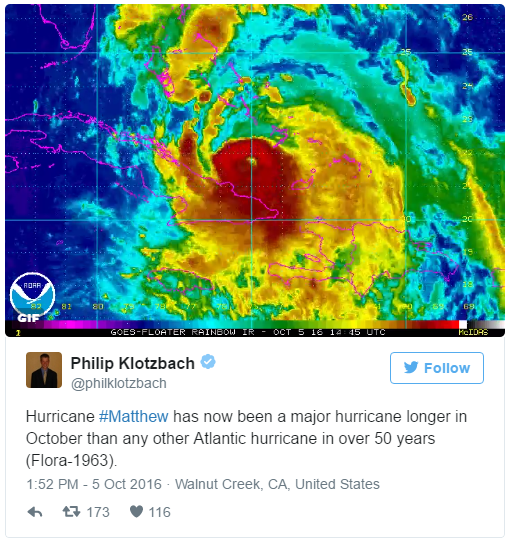
No, it's not rare to have hurricanes in October, but it is rare to see a hurricane continue at Major Hurricane status (Category 3 or higher) for as long as Matthew has this late in the season. Take a look at this tweet from Colorado State University meteorologist Philip Klotzbach, who is an expert in Atlantic hurricane forecasts. He states that "Hurricane Matthew has now been a major hurricane longer in October than any other Atlantic hurricane in over 50 years (since Flora in 1963)!
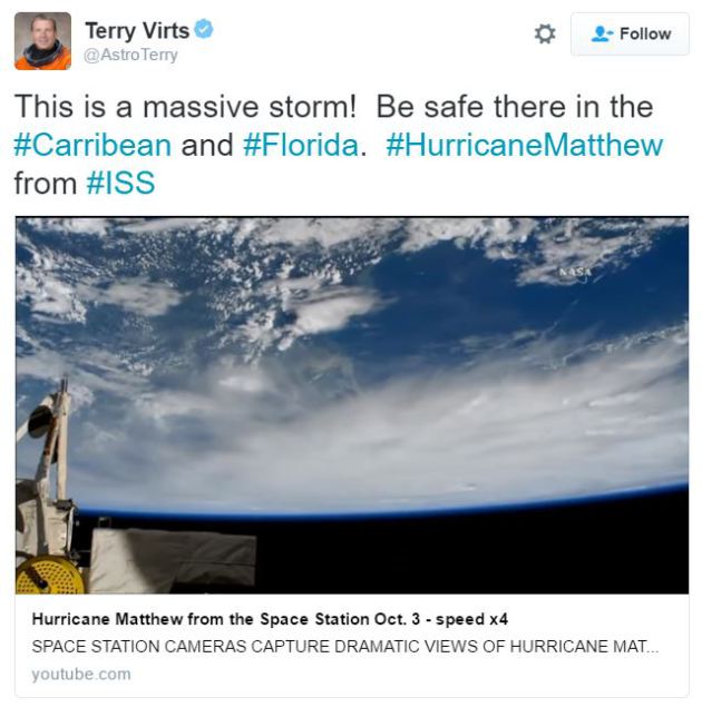
Take a look at this video that Terry Virts @AstroTerry posted as he flew over Hurricane Matthew from aboard the International Space Station midweek.
See the video HERE
________________________________________
Hurricane Matthew History


 ____________________________________
After battering Haiti, eastern Cuba and parts of the Bahamas with hurricane force winds and exceptional rainfall, Matthew is now on track to impact the Southeastern Friday and through the weekend. Latest forecasts have Matthew sustaining Major hurricane status (category 3 or higher) as it slides along the east coast of Florida on Friday and early Saturday morning. This could be a worst case scenario as intense winds will continue to batter much of the I-95 corridor and for miles on either side of it. Take a look at some of the strong wording the National Weather Service used in advance of Hurricane Matthew hitting:
"EXTREMELY DANGEROUS, LIFE-THREATENING WEATHER CONDITIONS EXPECTED"
"WIDESPREAD EXTENSIVE TO DEVASTATING WIND IMPACTS WILL BE FELT. AIRBORNE DEBRIS LOFTED BY EXTREME WINDS WILL BE CAPABLE OF BREACHING STRUCTURES, UNPROTECTED WINDOWS AND VEHICLES. EFFECTS SUCH AS THESE RANGING FROM THE COAST TO WELL INLAND HAVE NOT BEEN EXPERIENCED IN CENTRAL FLORIDA IN DECADES."
"LOCAL WINDS WILL EXCEED WHAT OCCURRED DURING THE HURRICANES OF 2004. ANY EVACUATIONS AND STRUCTURE PREPARATION SHOULD BE COMPLETED THIS AFTERNOON. TRAVEL WILL BE STRONGLY DISCOURAGED BEGINNING AT DUSK. EXPECT WIDESPREAD POWER OUTAGES."
"STRUCTURAL DAMAGE TO STURDY BUILDINGS, SOME WITH COMPLETE ROOF AND WALL FAILURES. COMPLETE DESTRUCTION OF MOBILE HOMES. DAMAGE GREATLY ACCENTUATED BY LARGE AIRBORNE PROJECTILES. LOCATIONS MAY BE UNINHABITABLE FOR WEEKS OR MONTHS."
"LARGE AREAS OF DEEP INUNDATION WITH STORM SURGE FLOODING ACCENTUATED BY BATTERING WAVES. STRUCTURAL DAMAGE TO BUILDINGS, WITH SEVERAL WASHING AWAY. DAMAGE COMPOUNDED BY FLOATING DEBRIS. LOCATIONS MAY BE UNINHABITABLE FOR AN EXTENDED PERIOD."
Florida Bracing for Matthew
Hurricane Watches and Warnings have been posted for parts of Florida and Georgia in advance of Matthew as it continues to slowly drift northwest toward the Peninsula. Latest forecast tracks take this along the east coast of Florida later this week/weekend ahead with significant impacts. Mandatory evacuations have already been order for parts of the state as Matthew threatens.
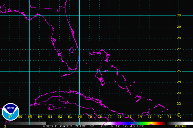
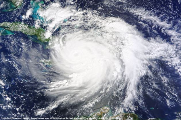
This was the view of Hurricane Matthew as of PM Thursday, which showed it moving through the Bahamas. This northwest track will continue until it reaches the east coast of Florida. It is then forecast to make a more northerly turn by the weekend.
Tracking Matthew
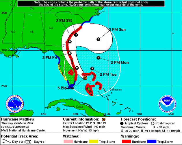
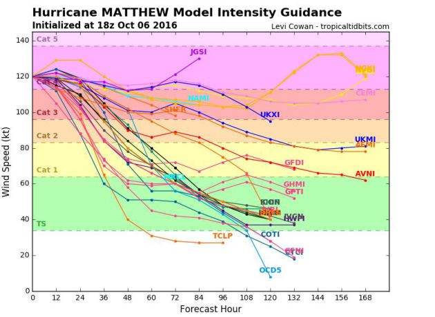
Here's the latest from the National Hurricane Center, which suggests Matthew will continue at major hurricane strength through the end of the week as it drifts towards the east coast of Florida. This will be a dangerous storm system and bears watching as the forecast track could change.
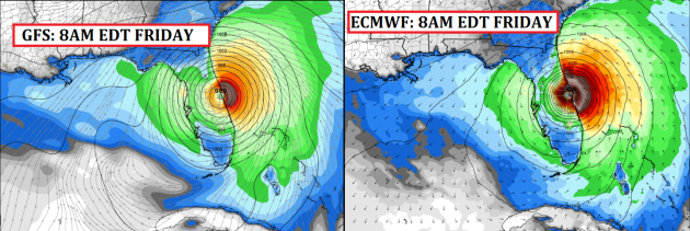
Here's the latest GFS and ECMWF track for Matthew by early Friday morning. Note that the storm looks to potentially take a very close track to the east coast of Florida. Interestingly, both models seem to be pretty close together at that point! This is a very disturbing signal as Matthew could be quite intense at this point.
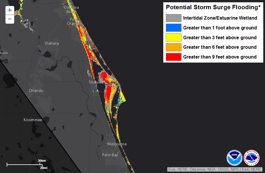
Storm Surge
Here the potential storm surge near Cape Canaveral and surrounding areas. Note that there are many areas along the coast that could see a storm surge near 9ft. or greater!
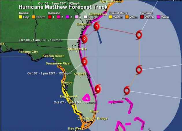
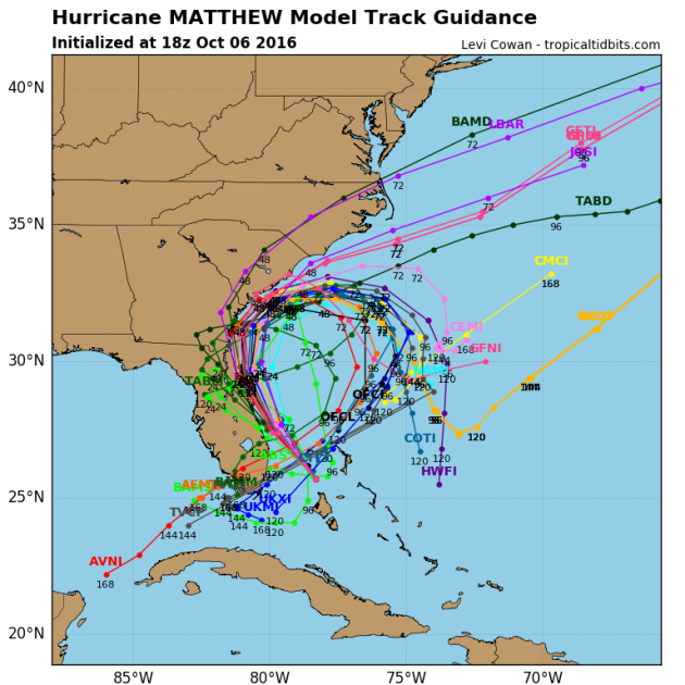
Tracking Matthew
Well, this is interesting. While some models take Matthew out to sea, some loop it back around into Florida by next week with a secondary heavy blow... stay tuned for latest forecasts.
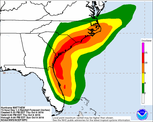
With Matthew tracking a little farther west, heavy rainfall is now going to be a major issue across the East Coast. Note that some locations could see up to 6" to 10"+ with some significantly higher tallies possible along the coast.
Tracking Matthew
After strengthening into a category 5 hurricane late last week (the first in the Atlantic basin since Felix in 2007; 9 years), models project that we may still see major hurricane strength (category 3 or higher) over the next few days.
_________________________________________________
No, it's not rare to have hurricanes in October, but it is rare to see a hurricane continue at Major Hurricane status (Category 3 or higher) for as long as Matthew has this late in the season. Take a look at this tweet from Colorado State University meteorologist Philip Klotzbach, who is an expert in Atlantic hurricane forecasts. He states that "Hurricane Matthew has now been a major hurricane longer in October than any other Atlantic hurricane in over 50 years (since Flora in 1963)!
Matthew from the International Space Station
See the video HERE
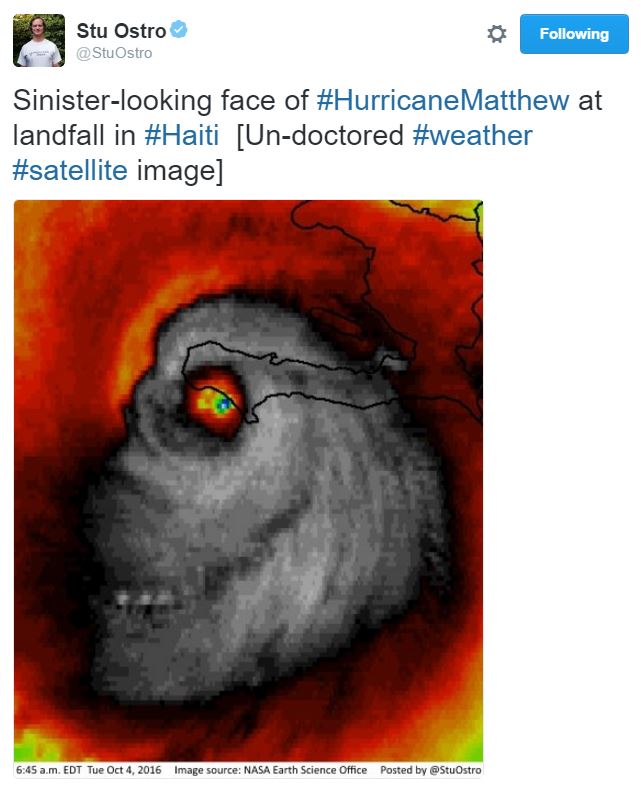
Images of Matthew
Here's an image of Hurricane Matthew that has been making the rounds on Twitter. This is a REAL infrared satellite image that was taken as Matthew was making landfall with Haiti early AM Tuesday. Kind of creepy, no?
________________________________________
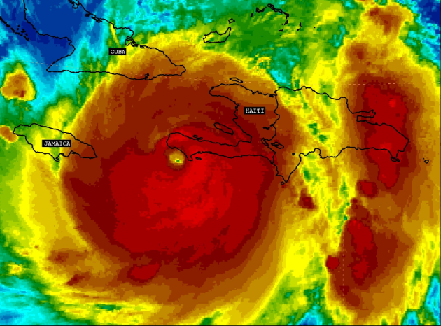
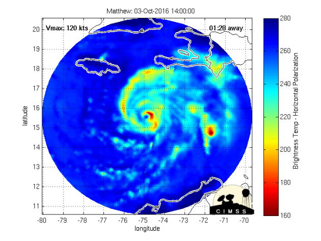
Hurricane Matthew became the 5th hurricane of the 2016 Atlantic hurricane season on Thursday of last week and strengthened rapidly into a MAJOR category 3 hurricane Friday morning. Overnight Friday, Matthew strengthened even more into a category 5 storm with sustained winds up to 160mph. Interestingly, Matthew became the first category 5 hurricane in the Atlantic Basin since Hurricane Felix in 2007. 7AM EDT Tuesday, Matthew made landfall in southwest Haiti as a strong category 4 storm with winds up to 145mph; this was the first category 4 hurricane to make landfall with Haiti since Cleo in 1964. The 2nd category 4 landfall occurred in eastern Cuba 8PM EDT Tuesday with winds of 140mph. This was the first category 4 land fall with Cuba since Ike in 2008! Interestingly, there have now been 15 category 4+ landfalls in recorded history, 7 of which have hit since 2001!
Matthew Made Two Category 4 Landfalls on Tuesday
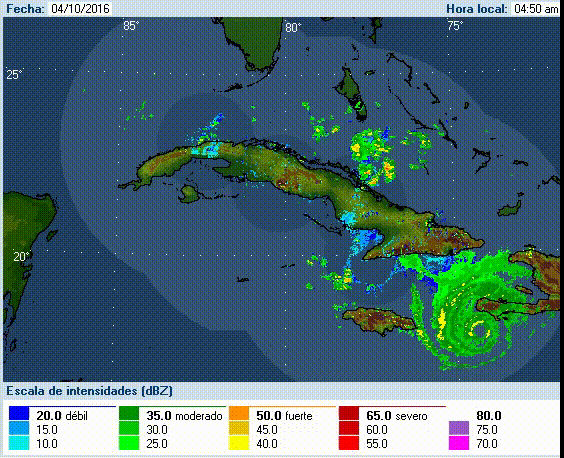
Take a look at the loops below, which show Matthew making landfall in southwestern Haiti and eastern Cuba on Tuesday, both as a category 4 storm with sustained winds near 140mph! This brought significant weather impacts to these areas, not only strong winds, but extreme rainfall tallies as well.
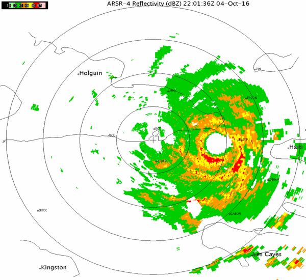
Radar Prior to Landfall with Haiti early AM Tuesday
Here's a look at the radar and an image from the Hurricane Hunter from inside the radar just prior to making landfall with southwestern Haiti early Tuesday morning. Note that the Hurricane Hunter estimated the eyewall to be nearly 14miles across at this point!
Radar Prior to Landfall PM Tuesday in Cuba
Here's another radar view and photo from inside the eye just prior to landfall with eastern Cuba late Tuesday.
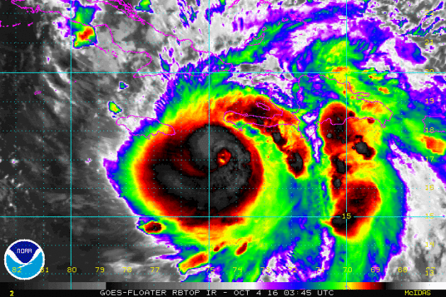
The Eye of Matthew
This is a high resolution visible satellite loop of Hurricane Matthew from late last week when it was near its peak intensity; high end category 4 to low end category 5 storm. What an impressive storm!
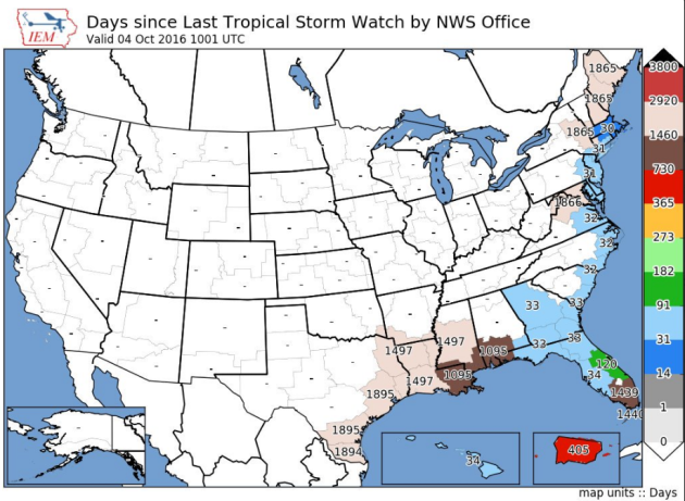
Days Since Late Tropical Watches
How about this stat! According to the @NWSKeyWest, prior to tropical watches being issued on Monday, it had been nearly 4 years since the last tropical storm watches had been issued for the Florida Keys!
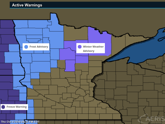
WINTER WEATHER ADVISOR
...SEVERAL HOURS OF HEAVY SNOW LIKELY OVERNIGHT... .A FAST-MOVING STORM SYSTEM WILL PASS THROUGH THE NORTHLAND OVERNIGHT AND FRIDAY MORNING BRINGING A SHORT PERIOD OF HEAVY SNOW TO PORTIONS OF NORTH CENTRAL AND NORTHEAST MINNESOTA OVERNIGHT. PRECIPITATION WILL BEGIN AS RAIN AND THEN QUICKLY CHANGE TO SNOW. SNOW RATES OF 1 TO 3 INCHES PER HOUR ARE POSSIBLE...BUT GIVEN WARM SURFACE TEMPERATURES...LOOK FOR SIGNIFICANT COMPACTION AND SOME MELTING TO LIMIT SNOW TOTALS. EVEN WITH WARM TEMPERATURES...THINK A SWATH OF 1 TO 3 INCHES IS LIKELY FROM THE BRAINERD LAKES TO KABETOGAMA. HIGHER ACCUMULATION IS EXPECTED ON GRASSY SURFACES AS WELL.
...WINTER WEATHER ADVISORY IN EFFECT FROM 10 PM THIS EVENING TO 7 AM CDT FRIDAY...
* LOCATIONS...THE HEAVIEST SNOW IS EXPECTED ALONG A NARROW CORRIDOR FROM THE BRAINERD LAKES TO GRAND RAPIDS...HIBBING...AND VIRGINIA...TO COOK...CRANE LAKE...AND KABETOGAMA. * TIMING...SNOW WILL SPREAD NORTHEAST FROM THE BRAINERD LAKES AREA LATE THIS EVENING...TO GRAND RAPIDS AND HIBBING AFTER MIDNIGHT...TO KABETOGAMA AND CRANE LAKE DURING THE EARLY MORNING HOURS. * SNOW ACCUMULATIONS...1 TO 3 INCHES.
* LOCATIONS...THE HEAVIEST SNOW IS EXPECTED ALONG A NARROW CORRIDOR FROM THE BRAINERD LAKES TO GRAND RAPIDS...HIBBING...AND VIRGINIA...TO COOK...CRANE LAKE...AND KABETOGAMA. * TIMING...SNOW WILL SPREAD NORTHEAST FROM THE BRAINERD LAKES AREA LATE THIS EVENING...TO GRAND RAPIDS AND HIBBING AFTER MIDNIGHT...TO KABETOGAMA AND CRANE LAKE DURING THE EARLY MORNING HOURS. * SNOW ACCUMULATIONS...1 TO 3 INCHES.
FROST ADVISORY
...FROST ADVISORY IN EFFECT FROM MIDNIGHT TONIGHT TO 10 AM CDT FRIDAY... THE NATIONAL WEATHER SERVICE IN GRAND FORKS HAS ISSUED A FROST ADVISORY...WHICH IS IN EFFECT FROM MIDNIGHT TONIGHT TO 10 AM CDT FRIDAY. * TEMPERATURES...FROM 33 TO 36 DEGREES. * TIMING...LATE TONIGHT INTO FRIDAY MORNING. PRECAUTIONARY/PREPAREDNESS ACTIONS... A FROST ADVISORY MEANS THAT WIDESPREAD FROST IS EXPECTED. SENSITIVE OUTDOOR PLANTS MAY BE KILLED IF LEFT UNCOVERED.
Another Surge of Rain and SNOW - PM Thursday/AM Friday
Here's the simulated radar from PM Thursday to AM Friday, which shows a batch of heavier rainfall moving through parts of Minnesota and Wisconsin. Note the blue color that shows up across parts of northern Minnesota! That's snow! Some spots there could see 1" to 3" of heavy, wet snow!
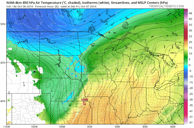
Turning Colder Late Week
Temperatures ahead of the cold front warmer into the 70s earlier this week, but note how much cooler it gets post front by the second half of the week. I wouldn't be surprised to see widespread frost and freeze headlines by the end of the week/weekend ahead.
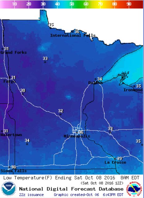
Frosty Friday Night Ahead - For Some
Take a look at the low temperatures expected across the state Friday night/AM Saturday. With lows dipping into the low to mid 30s, I could see widespread frost and freeze headlines posted later this week. Stay tuned!
_________________________________________
Signs of Fall Closer to Home
Signs of fall are starting to pop a little more each and every day. Things are a little more advanced across the central and northern part of the state, but we're getting there.

Feels Like Late October - "Matthew" Lashes Florida
"Extremely dangerous, life-threatening weather conditions expected."
"Locations may be uninhabitable for weeks or months."
This strong wording was released by the National Weather Service in Florida in advance of what could be some of the worst conditions that parts of the state have not experienced in decades!
Hurricane Matthew will lash Florida Friday in an almost a worst case scenario. The track takes it right along the, heavily populated, east coast and I-95 corridor with wind gusts exceeding 100mph and torrential rainfall. The danger is real.
Interestingly, Matthew looks to scrape the South Carolina coast early Saturday before looping back for a potential secondary smack in Florida next week.
Meanwhile, late October-like temperatures arrive Friday with a few wet flakes possible early Friday morning across the border. Colder air settles in Friday night for statewide patchy frost by AM Saturday. Yes, even some of the burbs could see a light frost!
Fall colors are peaking in N. MN now! Time to get your peep on.
1980: Summer-like heat occurs over Minnesota with highs of 92 at Montevideo and 84 at MSP airport.
________________________________
Average High/Low for Minneapolis
October 7th
 _______________________________________________________________________
___________________________________________________________
 ___________________________________________
"Climate change deal is a turning point for world, Obama says"
WASHINGTON — History may judge the Paris climate agreement as a turning point for the planet,President Obama said Wednesday as the United Nations reached a key threshold triggering the implementation of the climate accord. With nations representing more than 55% of world carbon emissions now having signed on to the agreement, the deal now goes into effect in 30 days. The agreement requires countries to come up with nation-specific carbon reduction plans in an effort to keep global temperatures from rising more than 2 degrees Celsius, or 3.6 degrees Fahrenheit, over pre-industrial levels. "Today is a historic day in the fight to protect our planet for future generations," Obama said. "Make no mistake: This agreement will help delay and avoid some of the worst consequences of climate change."
See more from USAToday HERE:
 ____________________________________________________________"Hurricane Matthew’s Strength Is Yet Another Climate Change Indicator"
"Hurricane Matthew, a record-shattering storm that is unusual for October, is a reminder of climate change’s potential to turn seasonal weather events into extreme, year-round threats. Matthew, which meteorologists downgraded from a rare Category 5 to a Katrina-magnitude Category 3 on Wednesday, could make landfall in southeast Florida as early as Thursday, and threatens northeast Florida and the coasts of Georgia and South Carolina through Saturday. The storm has already claimed at least 11 lives in Haiti, the Dominican Republic, Colombia and St. Vincent and the Grenadines. The storm has surpassed several milestones as one of the strongest, longest-lasting hurricanes of its kind on record. But on top of that, scientists note, it’s atypical for this time of year."
See more from HuffingtonPost HERE
 ______________________________________________________

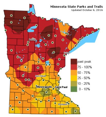
Fall Color Update
The latest update from the MN DNR shows that we are well on our way in the fall color department with several areas up north seeing peak colors (75% - 100%). There are even pockets of past peak colors across northern Minnesota. Note that much of the Twin Cities is 25% to 50% color and is turning quickly! By the way, the average peak there is generally late September to mid October.
_______________________________________________
Feels Like Late October - "Matthew" Lashes Florida
"Extremely dangerous, life-threatening weather conditions expected."
"Locations may be uninhabitable for weeks or months."
This strong wording was released by the National Weather Service in Florida in advance of what could be some of the worst conditions that parts of the state have not experienced in decades!
Hurricane Matthew will lash Florida Friday in an almost a worst case scenario. The track takes it right along the, heavily populated, east coast and I-95 corridor with wind gusts exceeding 100mph and torrential rainfall. The danger is real.
Interestingly, Matthew looks to scrape the South Carolina coast early Saturday before looping back for a potential secondary smack in Florida next week.
Meanwhile, late October-like temperatures arrive Friday with a few wet flakes possible early Friday morning across the border. Colder air settles in Friday night for statewide patchy frost by AM Saturday. Yes, even some of the burbs could see a light frost!
Fall colors are peaking in N. MN now! Time to get your peep on.
___________________________________________________
Extended Weather Outlook
THURSDAY NIGHT: Scattered showers, possibly a rumble of thunder. Winds: N 5-10. Low: 41.
FRIDAY: Passing clouds with a nippy wind. A few AM flakes up north? Winds: W 10-20. High: 54.
FRIDAY NIGHT: Partly cloudy, quiet and chilly. Patchy frost develops. Winds: NW 5. Low: 36.
SATURDAY: Some frost in the burbs. Chilly with patchy clouds. Winds: NW 5-10. High: 55.
SUNDAY: Crisp sunshine. Winds: SE 5-10. Wake-up: 39. High: 63.
MONDAY: Clouds increase. A few PM showers?. Winds: SSW 5-15. Wake-up: 51. High: 70.
TUESDAY: Cloudier. Slight chance of light rain. Winds: NNW 5-10. Wake-up: 52. High: 64.
WEDNESDAY: Skies clear. Cooler breeze. Winds: NE 5-10. Wake-up: 45. High: 60.
THURSDAY: Mostly cloudy. Passing PM shower? Wind: SE 5-10. Wake-up: 42. High: 59.
_______________________________
_______________________________
This Day in Weather History
October 7th
2003: Record high temperatures are seen across the area. St. Cloud's high is 86 degrees. Minneapolis ties their record high of 85 degrees set in 1997, and Alexandria sets their record high of 88 degrees. Forest Lake reaches a record-setting 82 degrees, along with Stillwater at 84 degrees.October 7th
1980: Summer-like heat occurs over Minnesota with highs of 92 at Montevideo and 84 at MSP airport.
________________________________
Average High/Low for Minneapolis
October 7th
Average High: 62F (Record: 85F set in 2011)
Average Low: 43F (Record: 25F set in 1976)
_________________________________
Average Low: 43F (Record: 25F set in 1976)
_________________________________
Sunrise/Sunset Times for Minneapolis
October 7th
October 7th
Sunrise: 7:18am
Sunset: 6:43pm
Sunset: 6:43pm
*Daylight Lost Since Yesterday: ~3mins & 4sec
*Daylight Lost Since Summer Solstice: ~4hours and 14mins
______________________________________________________________________
*Daylight Lost Since Summer Solstice: ~4hours and 14mins
______________________________________________________________________
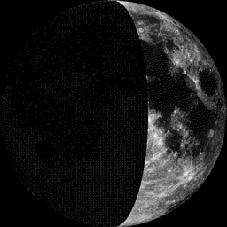
Moon Phase for October 7th at Midnight
0.9 Days Before First Quarter
0.9 Days Before First Quarter
Weather Outlook Friday
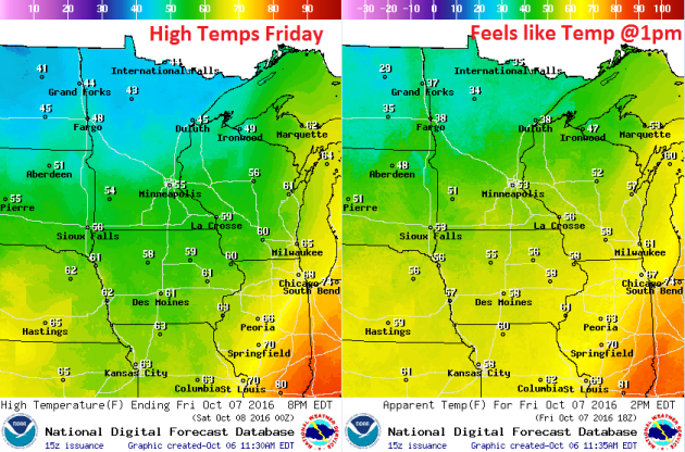
High temperatures on Friday will be MUCH cooler than what we've been dealing with over past several days. With highs in the 40s and 50s across the state, it'll feel very much like late October. Note that feels like temperatures around midday could still be in the 30s across northern Minnesota! Grab your jacket!
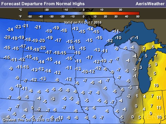
High Temperatures From Average Friday
High temperatures on Friday will be running nearly 5F to 15F below average across much of the Upper Midwest with some locations close to 20F below average!
Weather Outlook Friday
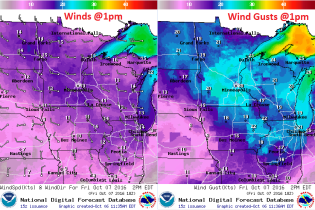
Winds on Friday will be quite nippy. With temperatures in the 40s and 50s with winds 10mph to 20mph, it's feel a little raw out there.
Weather Outlook Friday
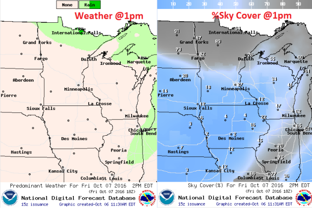
The secondary surge of rain that moves through PM Thursday/AM Friday will quickly move east on Friday. In the wake of the steadier rainfall, skies will clear a bit across the southern half of the state. Note that areas across northern Minnesota will still be locked under clouds with a few passing showers. Interestingly, some spots across northern Minnesota may even see a few wet snowflakes early Friday.
___________________________________________________________
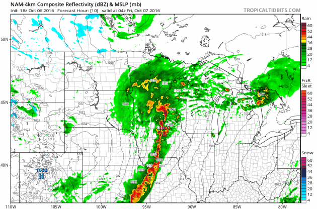
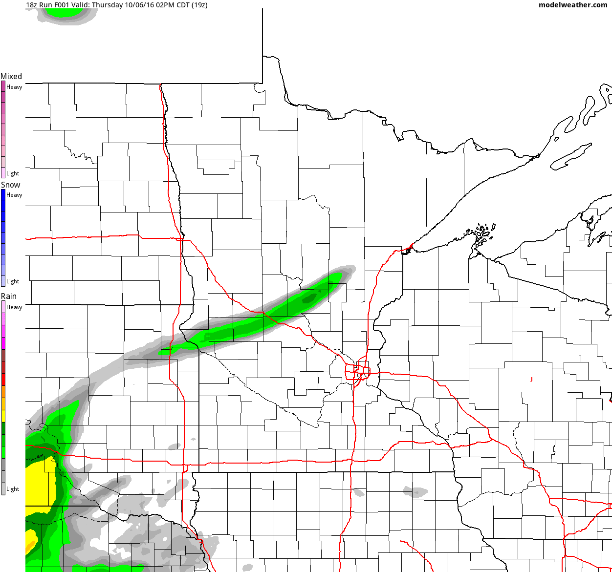
Simulated Radar
The simulated radar from PM Thursday to Sunday shows another surge of rain moving in PM Tuesday to AM Friday. Note the lingering precipitation along the international border. Some of this could be in the form a few wet snowflakes along the border.
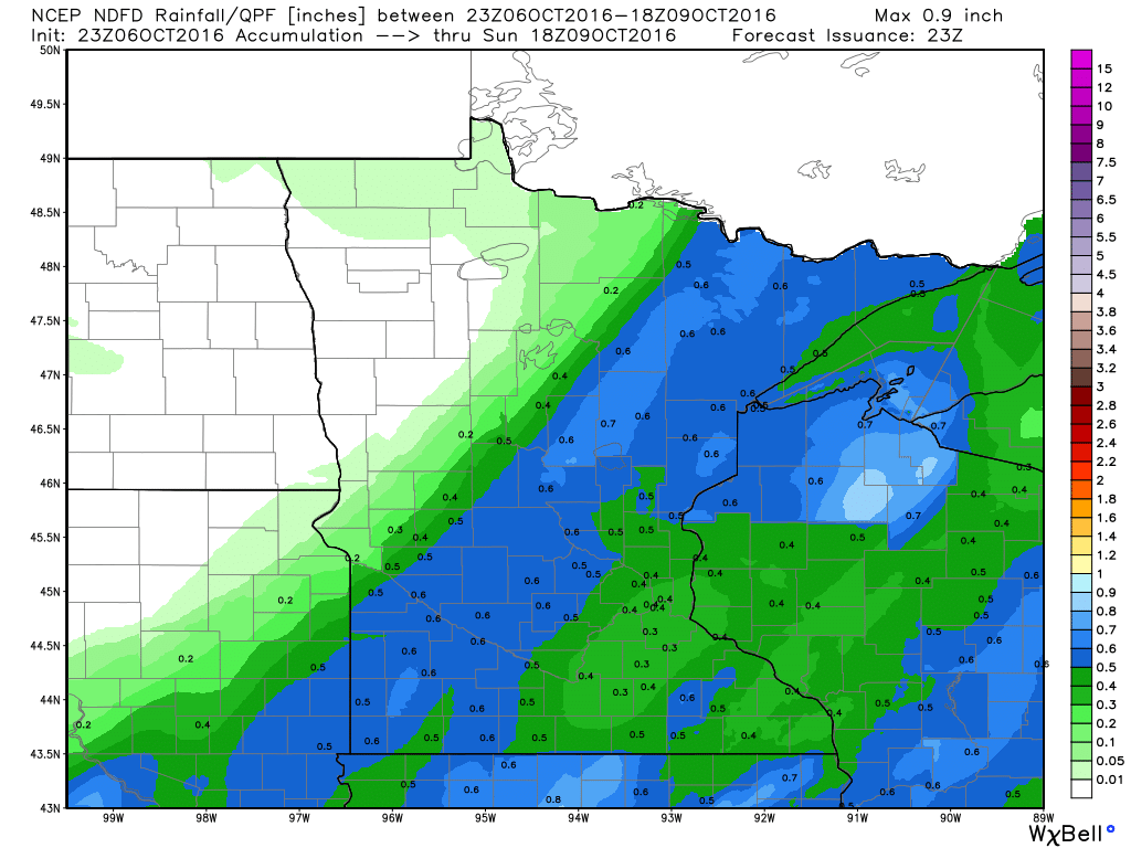
Rainfall Potential
Rainfall potential through Sunday suggests another round of showers moving in late Thursday. This batch looks a little lighter than what we had on PM Tuesday/AM Wednesday, but some could still see up to 0.5" or more, especially across the southeastern part of the state where a few thundershowers can't be ruled out.
_________________________________________
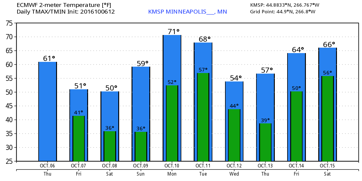
Extended Weather Outlook
The extended temperature outlook over the next 10 days suggests colder temperatures now through the weekend with highs Friday - Sunday at their coldest. Highs in the 50s and overnight lows in the 30s will feel very much like late October as temperatures dip 10° to 15° below average.
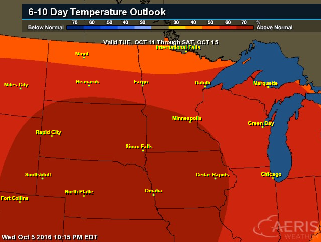
Warm Temperatures Return to Midwest
According to NOAA's CPC, the 6 to 10 day temperature outlook suggests warmer than average temperatures returning to much of the Upper Midwest next week!
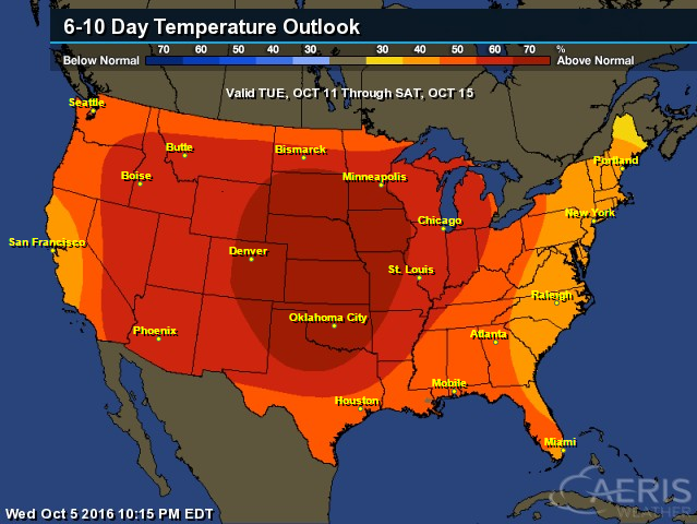
6 to 10 Day Temp Outlook
Here's the national temperature outlook from October11th - 15th, which shows warmer than average conditions across much of the nation.
__________________________________________
National Weather Outlook
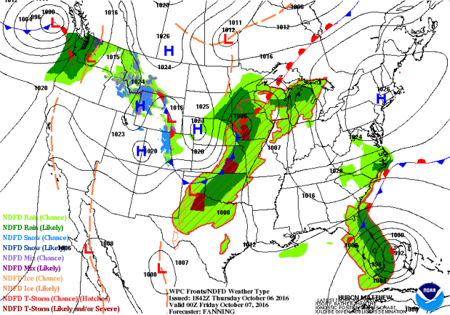
The same storm system that produced heavier snowfall across the high elevations across the Intermountain West will move east through the end of the week along with its colder air. Another surge of moisture will push through the Upper Midwest PM Thursday/AM Friday with a few rumbles of thunder and some isolated strong to severe storms across the Central U.S.. Note Hurricane Matthew moving into Florida and the Southeast with major impacts there.
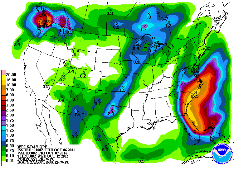
Precipitation Outlook
The heaviest rainfall over the next few days will be associated will Matthew in the Southeast, especially along the coast. Some spots could see 6" to 10"+, which could lead to major flooding.
___________________________________________
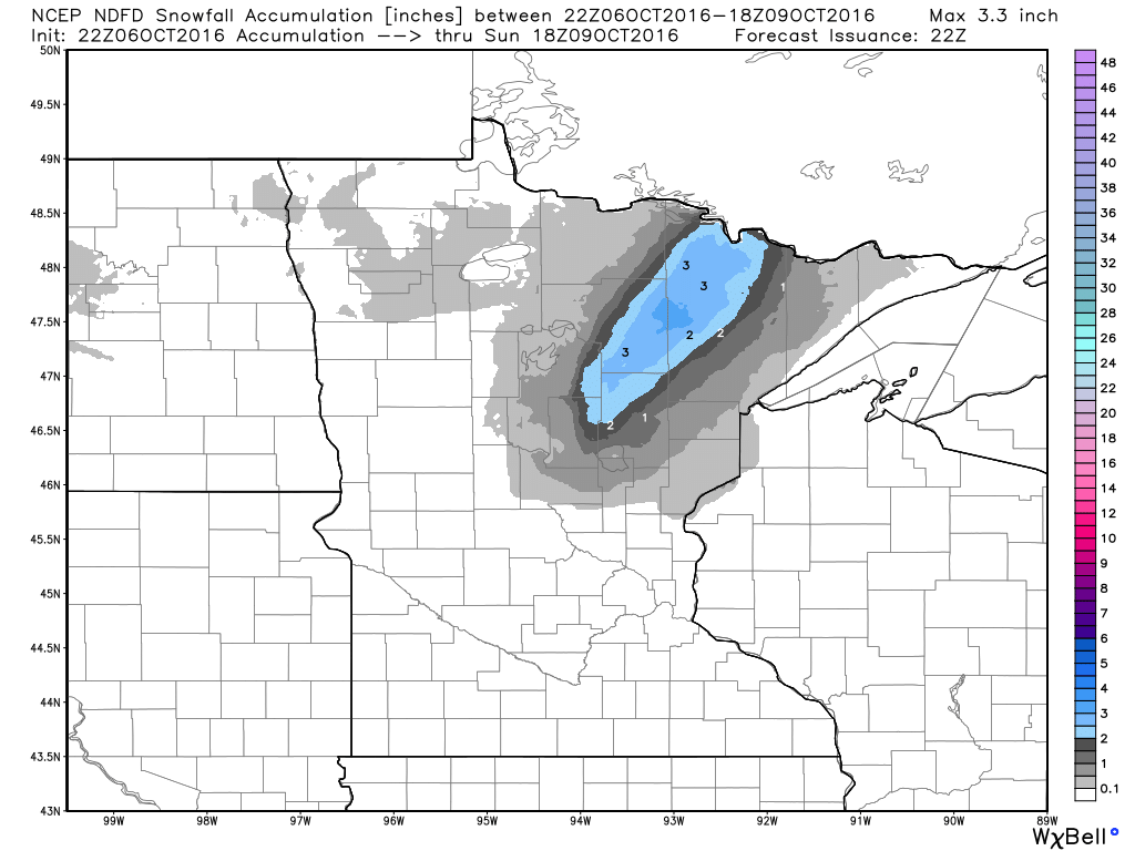
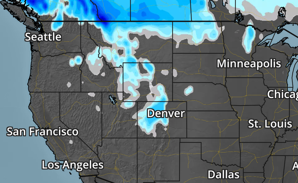
Snowfall Potential
Snowfall will linger across the Intermountain West as cold air and moisture linger there. However, note that there may be some light accumulations across the High Plains and the Dakotas through late week.
 Snow in Canada
How about this! Here's a picture of heavy snow from Cypress Hills in Saskatchewan Canada. This picture shows that more than 2 feet of snow fell there!
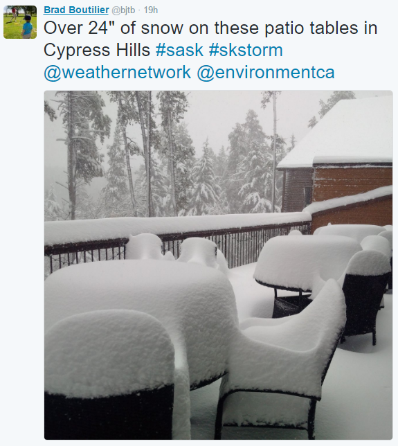
__________________________________________________________________How about this! Here's a picture of heavy snow from Cypress Hills in Saskatchewan Canada. This picture shows that more than 2 feet of snow fell there!
"Climate change deal is a turning point for world, Obama says"
WASHINGTON — History may judge the Paris climate agreement as a turning point for the planet,President Obama said Wednesday as the United Nations reached a key threshold triggering the implementation of the climate accord. With nations representing more than 55% of world carbon emissions now having signed on to the agreement, the deal now goes into effect in 30 days. The agreement requires countries to come up with nation-specific carbon reduction plans in an effort to keep global temperatures from rising more than 2 degrees Celsius, or 3.6 degrees Fahrenheit, over pre-industrial levels. "Today is a historic day in the fight to protect our planet for future generations," Obama said. "Make no mistake: This agreement will help delay and avoid some of the worst consequences of climate change."
See more from USAToday HERE:
"Hurricane Matthew, a record-shattering storm that is unusual for October, is a reminder of climate change’s potential to turn seasonal weather events into extreme, year-round threats. Matthew, which meteorologists downgraded from a rare Category 5 to a Katrina-magnitude Category 3 on Wednesday, could make landfall in southeast Florida as early as Thursday, and threatens northeast Florida and the coasts of Georgia and South Carolina through Saturday. The storm has already claimed at least 11 lives in Haiti, the Dominican Republic, Colombia and St. Vincent and the Grenadines. The storm has surpassed several milestones as one of the strongest, longest-lasting hurricanes of its kind on record. But on top of that, scientists note, it’s atypical for this time of year."
See more from HuffingtonPost HERE
Thanks for checking in and don't forget to follow me on Twitter @TNelsonWX
No comments:
Post a Comment