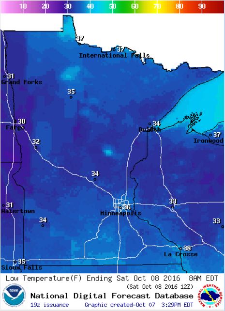
...FROST ADVISORY IN EFFECT FROM 3 AM TO 9 AM CDT SATURDAY...
* TEMPERATURE...LOW TO MID 30S.
* IMPACTS...SENSITIVE VEGETATION WILL BE DAMAGED OR KILLED IF LEFT UNPROTECTED.
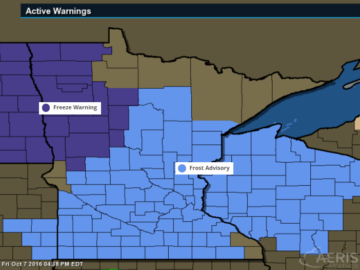
Frosty Friday Night Ahead - For Some
Take a look at the low temperatures expected across the state Friday night/AM Saturday. With lows dipping into the low to mid 30s. There may even be a few locations that dip into the upper 20s across the eastern Dakotas and far western Minnesota.
_____________________________________
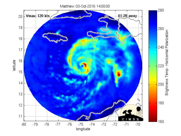
Hurricane Matthew Continues
Hurricane Matthew never made landfall with Florida. The storm tracked just a little farther than anticipated, which may have helped keep the worst of the winds offshore. However, there was still A LOT of damage as hurricane force and tropical storm force winds battered the state much of the day Friday. The storm will continue tracking north/northeast with Georgia and the Carolinas see the worst through the weekend.
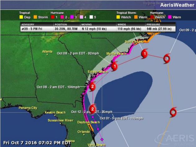
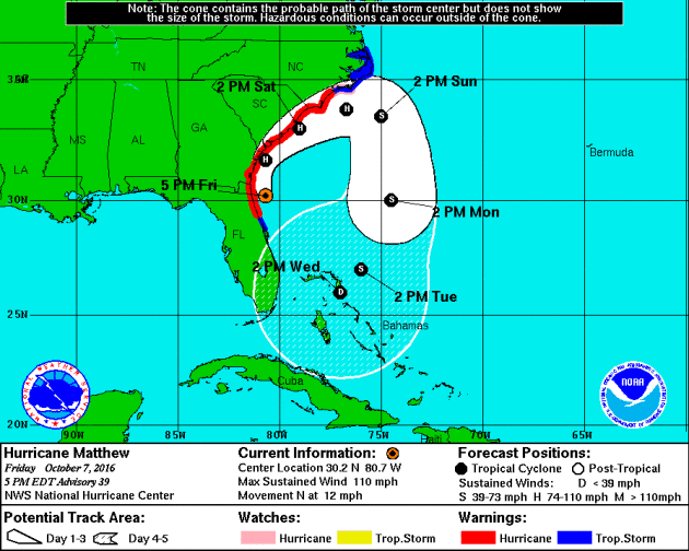
Tracking Matthew
The forecast from the National Hurricane Center suggests that Matthew will slowly weaken over the weekend with continued impacts along the coast and places inland. Note that it takes a very close track to the South Carolina coast, which could mean strong winds and a better potential of damage there. The storm appears to finally slide east, away from the coast by late weekend and early next week.
Extended Forecast
Interestingly, Matthew may loop around to impact the Bahamas and potentially southern Florida again by the second half of next week. Maybe not as strong as it was during the first pass, but heavy rainfall would still be an issue.
Tracking Matthew
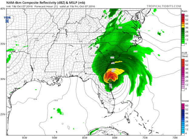
The forecast track for Matthew shows it hugging the coast through the weekend, but heavy rainfall potential will be possible for locations across much of the Mid-Atlantic States.
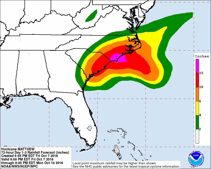
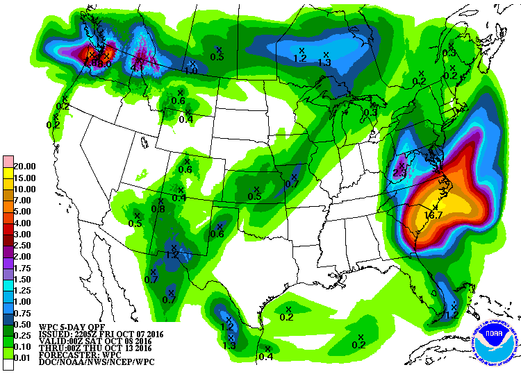
Heavy Rainfall Potential
Here's the rainfall forecast through PM Monday, which suggests heavy rainfall across the eastern portions of the Carolinas. Some spots could see 6" to 12"+, especially across southern North Carolina.
__________________________________
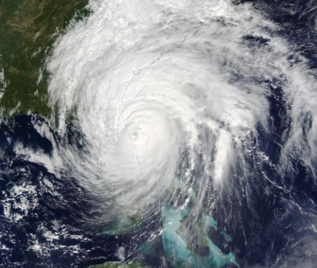
Images of Matthew
Here are a couple of images from @NASAGoddardPix, which snow Hurricane Matthew up close and from afar!

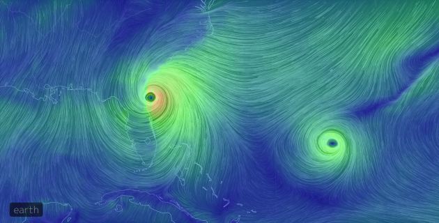
Matthew Stealing the Show
The wind circulation imagery is pretty impressive of Hurricane Matthew, but not the other circulation to the east. That is Nicole, which actually became a hurricane earlier this week, but never posed a threat to any major landmass, so Matthew continued to steal the show.
_________________________________________
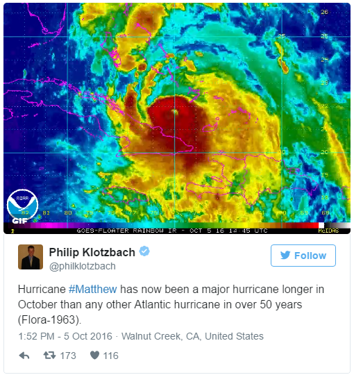
No, it's not rare to have hurricanes in October, but it is rare to see a hurricane continue at Major Hurricane status (Category 3 or higher) for as long as Matthew has this late in the season. Take a look at this tweet from Colorado State University meteorologist Philip Klotzbach, who is an expert in Atlantic hurricane forecasts. He states that "Hurricane Matthew has now been a major hurricane longer in October than any other Atlantic hurricane in over 50 years (since Flora in 1963)!
________________________________________
Hurricane Matthew became the 5th hurricane of the 2016 Atlantic hurricane season on Thursday of last week and strengthened rapidly into a MAJOR category 3 hurricane Friday morning. Overnight Friday, Matthew strengthened even more into a category 5 storm with sustained winds up to 160mph. Interestingly, Matthew became the first category 5 hurricane in the Atlantic Basin since Hurricane Felix in 2007. 7AM EDT Tuesday, Matthew made landfall in southwest Haiti as a strong category 4 storm with winds up to 145mph; this was the first category 4 hurricane to make landfall with Haiti since Cleo in 1964. The 2nd category 4 landfall occurred in eastern Cuba 8PM EDT Tuesday with winds of 140mph. This was the first category 4 land fall with Cuba since Ike in 2008! Interestingly, there have now been 15 category 4+ landfalls in recorded history, 7 of which have hit since 2001!
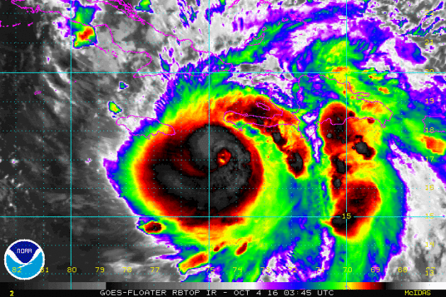
Matthew Made Two Category 4 Landfalls on Tuesday
Take a look at the loops below, which show Matthew making landfall in southwestern Haiti and eastern Cuba on Tuesday, both as a category 4 storm with sustained winds near 140mph! This brought significant weather impacts to these areas, not only strong winds, but extreme rainfall tallies as well.
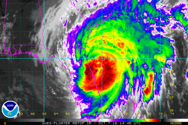
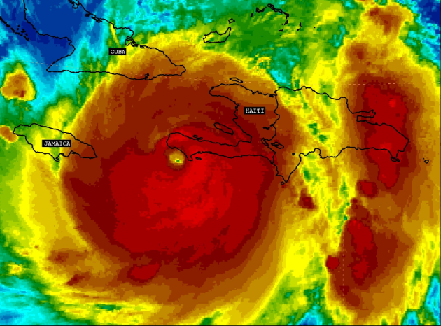
The Eye of Matthew
This is a high resolution visible satellite loop of Hurricane Matthew from late last week when it was near its peak intensity; high end category 4 to low end category 5 storm. What an impressive storm!

____________________________________
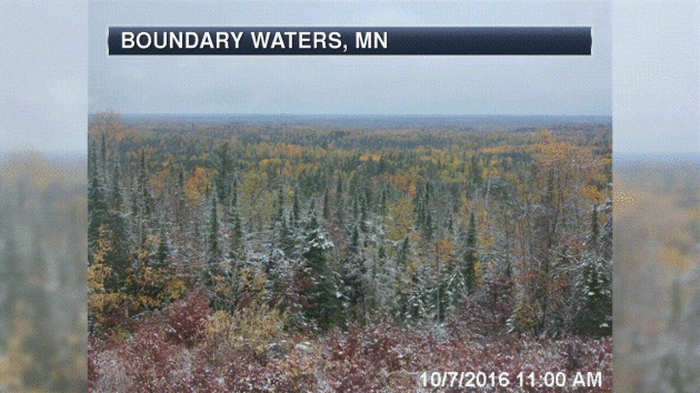
Signs of Fall Closer to Home
Signs of fall are starting to pop a little more each and every day. Things are a little more advanced across the central and northern part of the state, but we're getting there.
________________________________
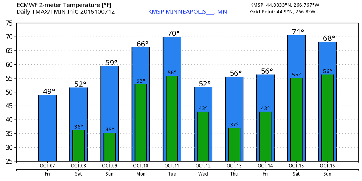
Average High/Low for Minneapolis
October 7th
 _______________________________________________________________________
___________________________________________________________
 _________________________________________
_______________________________________________

____________________________________________"World needs $90tn infrastructure overhaul to avoid climate disaster, study finds"
"Report by Global Commission on the Economy and Climate says world needs ‘urgent’ shift away from carbon-heavy infrastructure over the next 15 years. A gigantic overhaul of the world’s buildings, public transport and energy infrastructure costing trillions of dollars is required if dangerous climate change is to be avoided, according to a major new report. The study by the Global Commission on the Economy and Climate, which is co-chaired by prominent climate economist Lord Nicholas Stern, found that the world is expected to invest about $90tn in infrastructure over the next 15 years, requiring an “urgent” shift to ensure that this money is spent on low-carbon, energy-efficient projects. Such smart investment over the next two or three years could help ameliorate the climate crisis, but “the window for making the right choices is narrow and closing fast”. The report states that more than 60% of the world’s greenhouse gases are associated with ageing power plants, roads, buildings, sanitation and other structures. Around 1,500 coal plants are estimated to already be in construction worldwide, which would send the world spiraling towards disastrous environmental changes. Carbon-heavy infrastructure “literally kills people by causing deadly respiratory illnesses, exacerbating road accidents and spreading unclean drinking water, among other hazards”, the report reads."

______________________________________________________

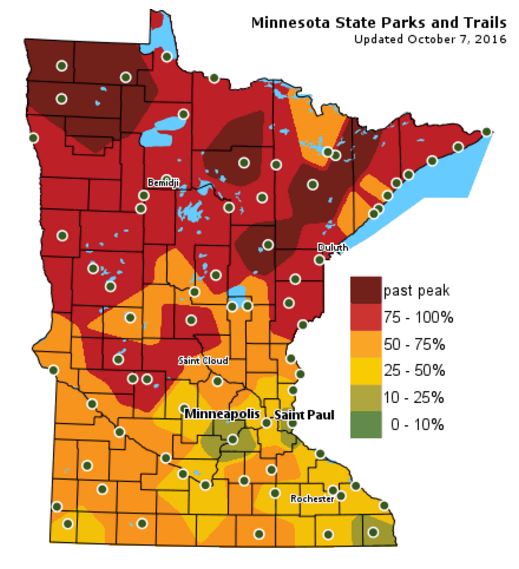
Fall Color Update
The latest update from the MN DNR shows that we are well on our way in the fall color department with several areas up north seeing peak colors (75% - 100%). There are even pockets of past peak colors across northern Minnesota. Note that much of the Twin Cities is 25% to 50% color and is turning quickly! By the way, the average peak there is generally late September to mid October.
_______________________________________________
First Frost For Many Towns - Tracking Matthew
A friend told me about a billboard on Hwy 371 between Nisswa and Walker. "Moving To Canada? We Can Help!" the realtor proclaims. During this year's campaign (rumble) it's almost a relief to talk
about the weather.
about the weather.
Many plants froze their buds off this AM Saturday, but the urban heat island extended the growing season for the immediate metro area by a few more days. Fall color is now peaking up
north, where a coating of Friday snow framed dazzling shades of rust, lemon and tangerine. This is a good time of year, after the shrieking storms of summer, before talk of plowable snows and stinging
wind chill.
north, where a coating of Friday snow framed dazzling shades of rust, lemon and tangerine. This is a good time of year, after the shrieking storms of summer, before talk of plowable snows and stinging
wind chill.
Expect 50s Saturday, 60F Sunday and 70F Tuesday before the next inevitable temperature tumble.
After sparing the east coast of Florida a direct hit, Hurricane Matthew is pushing ashore near Charleston Saturday morning, still capable of a destructive storm surge. For the record had Matthew tracked 40 miles farther west flood damage from Palm Beach to Jacksonville would have been extreme. Florida dodged a bullet.
Remind me to never complain about cold fronts or frosty fall mornings.
___________________________________________________
___________________________________________________
Extended Weather Outlook
FRIDAY NIGHT: Partly cloudy, quiet and chilly. Patchy frost develops. Winds: W 5-10. Low: 36.
SATURDAY: Some AM frost in the burbs. Partly sunny and brisk. Winds: NW 5-10. High: 56.
SATURDAY NIGHT: Partly cloudy and chilly. Winds: NNW 5. Low: 38.
SUNDAY: Sunny, breezy and a bit milder. Winds: SE 8-13. High: 60.
MONDAY: Windy, isolated shower? Winds: SSW 15-25. Wake-up: 49. High: 68.
TUESDAY: Mild start. Clouds and showers late. Winds: NW 10-15. Wake-up: 57. High: 70.
WEDNESDAY: Intervals of sun. Chilly breeze. Winds: NW 10-15. Wake-up: 43. High: 53.
THURSDAY: Frosty start. Bright sunshine. Winds: SE 5-10. Wake-up: 36. High: 57.
FRIDAY: Clouds and winds increase. Winds: S 10-15. Wake-up: 43. High: 59.
_______________________________
_______________________________
This Day in Weather History
October 8th
1949: A record-setting 3.17 inches of rain falls at Eau Claire.October 8th
________________________________
Average High/Low for Minneapolis
October 7th
Average High: 62F (Record: 85F set in 2011)
Average Low: 43F (Record: 25F set in 1976)
_________________________________
Average Low: 43F (Record: 25F set in 1976)
_________________________________
Sunrise/Sunset Times for Minneapolis
October 8th
October 8th
Sunrise: 7:20am
Sunset: 6:40pm
Sunset: 6:40pm
*Daylight Lost Since Yesterday: ~3mins & 4sec
*Daylight Lost Since Summer Solstice: ~4hours and 18mins
______________________________________________________________________
*Daylight Lost Since Summer Solstice: ~4hours and 18mins
______________________________________________________________________
Moon Phase for October 8th at Midnight
0.1 Since First Quarter
0.1 Since First Quarter
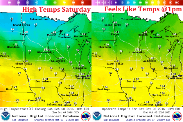
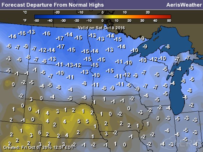
Weather Outlook Saturday
High temperatures on Saturday will be cool once again, but maybe not quite as biting as it was on Friday. Some spots across the northern part of the state may not even make it out of the 40s. The southern half of the state will be stuck in the 50s.
High Temperatures From Average Saturday
High temperatures on Saturday will still be running nearly 10F to 15F below average, which will feel more like late October.
Weather Outlook Saturday
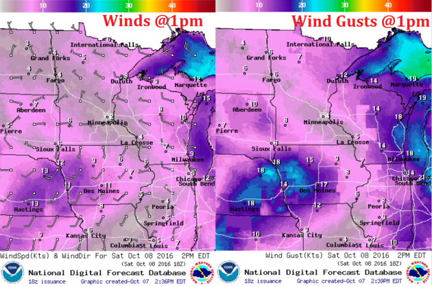
The good news is that winds on Saturday won't be quite as strong as they were on Friday. The only spot that may see lingering 'breezier' conditions will be near the Arrownheat
Weather Outlook Saturday
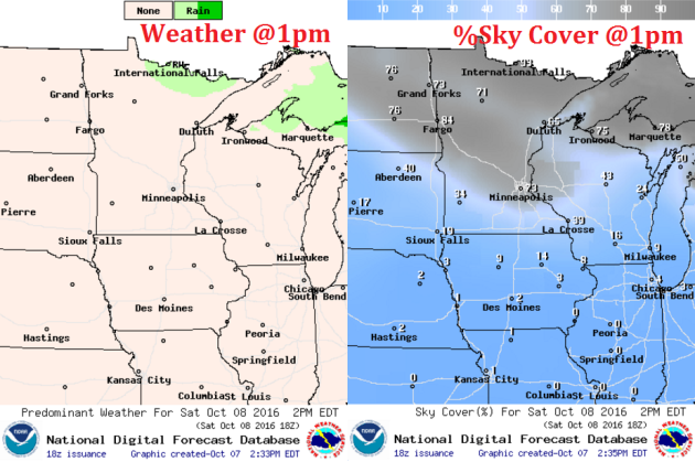
Spits of rain will still be possible across the northern half of the state on Saturday as cool air continues across the region. Much of the state will remain dry though with mostly sunny skies possible across the extreme southern part of the state.
___________________________________________________________
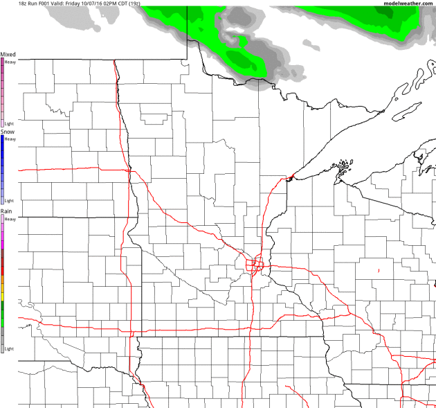
Simulated Radar
The simulated radar from PM Friday to Monday shows a few lingering showers across the northern half of the state early this weekend, but things should clear out nicely as we head into Sunday.
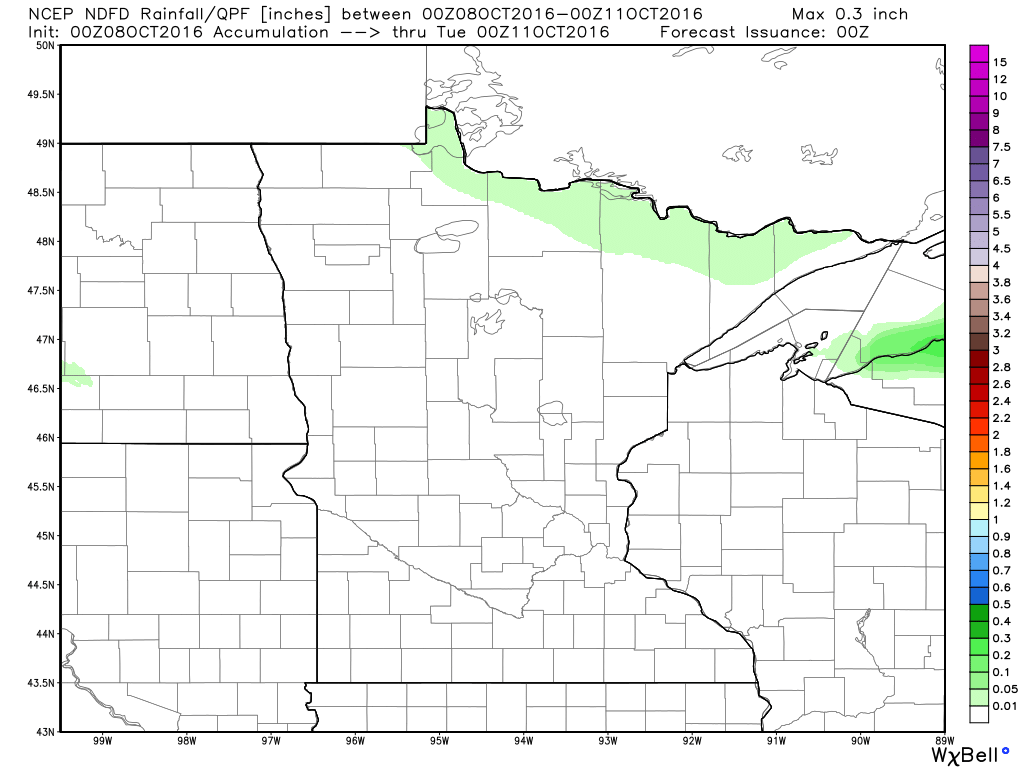
Rainfall Potential
Rainfall potential through Monday shows mostly dry conditions across the state. There may be a little across the northern part of the state, but if anything falls, it should be light.
_________________________________________
Extended Weather Outlook
The extended temperature outlook over the next 10 days suggests colder temperatures through the weekend, but note the gradual warming to near 70F by Tuesday! We may see another cold front by the second half of next week before another surge of milder air moves in next weekend.
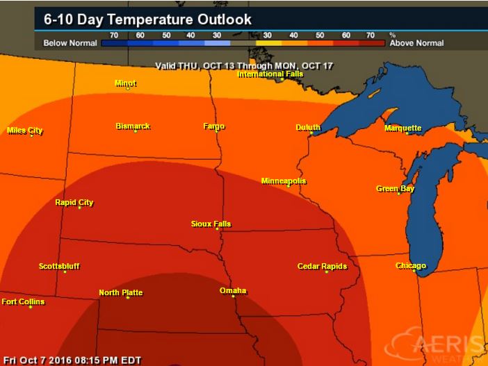
Warm Temperatures Return to Midwest
According to NOAA's CPC, the 6 to 10 day temperature outlook suggests warmer than average temperatures returning to much of the Upper Midwest next week!
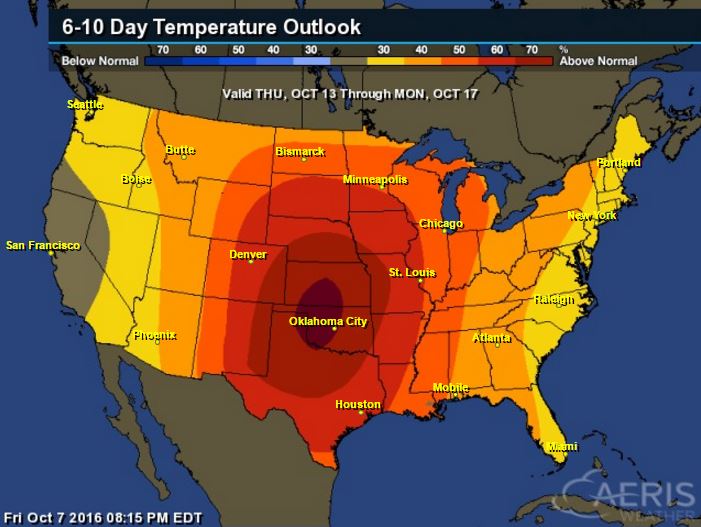
6 to 10 Day Temp Outlook
Here's the national temperature outlook from October 13th - 17th, which shows warmer than average conditions across much of the nation.
__________________________________________
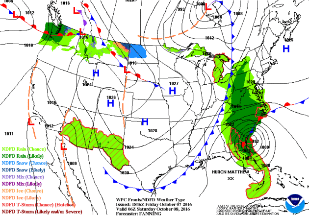
National Weather Outlook
While Hurricane Matthew will continue across parts of the Mid-Atlantic states this weekend, quieter weather conditions will be found across much of the Central U.S. this weekend in the wake of the cold front. It appears that much quieter weather conditions will be found across the nation by the end of the weekend with a few areas of rain near the Four Corners region and the Pacific Northwest.
Precipitation Outlook
The heaviest rainfall over the next few days will be associated will Matthew in the Mid-Atlantic. Some spots could see double digit rainfall tallies, which could lead to significant flooding.
_______________________________________________
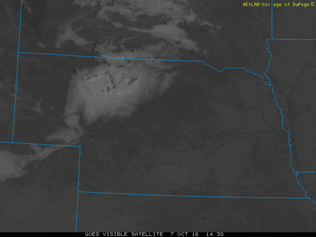
Melting Snow on Radar
It snowed earlier this week in Nebraska. This was the visible satellite loop from Friday, which showed the snow melting quite rapidly during the day!
______________________________________________________
"New Actions to Tackle Climate through Sports"
"Summary:
Responding to a call to action issued this summer, teams, venues, leagues, schools, and organizations are announcing new actions to use sports to combat climate change."
"Today, on the inaugural Green Sports Day and in line with the Pittsburgh Penguins' visit to the White House to celebrate their Stanley Cup victory, the White House Office of Science and Technology Policy is announcing a set of exciting new actions by Federal agencies and outside organizations who are using innovative approaches to tackle climate change through sports.
____________________________________________"World needs $90tn infrastructure overhaul to avoid climate disaster, study finds"
"Report by Global Commission on the Economy and Climate says world needs ‘urgent’ shift away from carbon-heavy infrastructure over the next 15 years. A gigantic overhaul of the world’s buildings, public transport and energy infrastructure costing trillions of dollars is required if dangerous climate change is to be avoided, according to a major new report. The study by the Global Commission on the Economy and Climate, which is co-chaired by prominent climate economist Lord Nicholas Stern, found that the world is expected to invest about $90tn in infrastructure over the next 15 years, requiring an “urgent” shift to ensure that this money is spent on low-carbon, energy-efficient projects. Such smart investment over the next two or three years could help ameliorate the climate crisis, but “the window for making the right choices is narrow and closing fast”. The report states that more than 60% of the world’s greenhouse gases are associated with ageing power plants, roads, buildings, sanitation and other structures. Around 1,500 coal plants are estimated to already be in construction worldwide, which would send the world spiraling towards disastrous environmental changes. Carbon-heavy infrastructure “literally kills people by causing deadly respiratory illnesses, exacerbating road accidents and spreading unclean drinking water, among other hazards”, the report reads."
______________________________________________________
Thanks for checking in and don't forget to follow me on Twitter @TNelsonWX
No comments:
Post a Comment