Pink Sunrise Tuesday
The sunrise on Tuesday cast a pink hue thanks to scattered showers that developed across the region. This second heavier round of rain developed PM Tuesday.
 Tuesday Morning Showers
The visible satellite loop from early Tuesday showed the scattered showers that pushed through the Twin Cities metro.
.gif)
The sunrise on Tuesday cast a pink hue thanks to scattered showers that developed across the region. This second heavier round of rain developed PM Tuesday.
The visible satellite loop from early Tuesday showed the scattered showers that pushed through the Twin Cities metro.
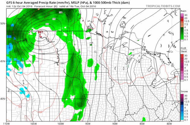
Storm System(s) This Week
A storm system brewing in the Western U.S. will continue to move through the Upper Midwest through the middle part of the week with scattered showers and storms along the cold front. Heavier rainfall potential may be possible along the cold front as it moves through the Mississippi River Valley PM Tuesday/AM Wednesday. Note that temperatures may even be cold enough for snow potential across NW North Dakota and even along the international border.
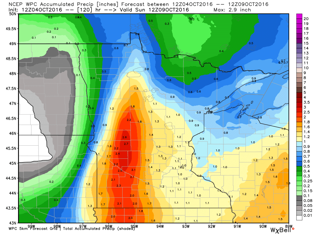
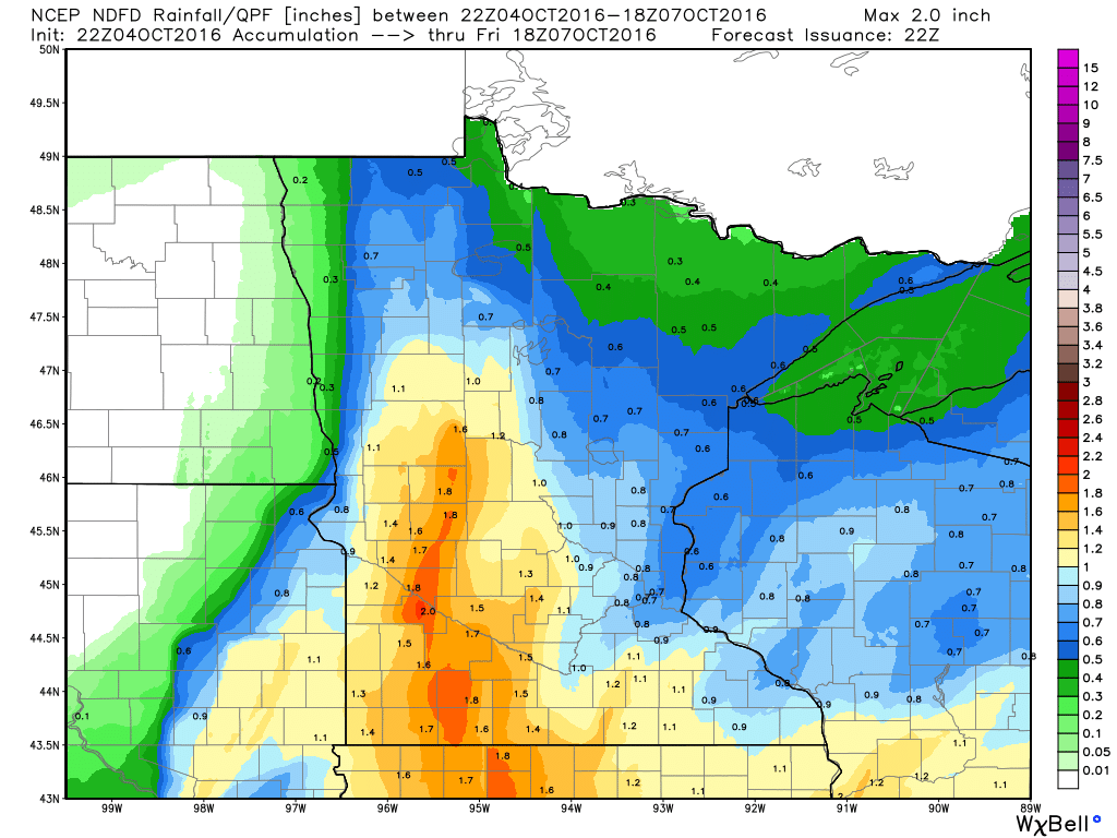
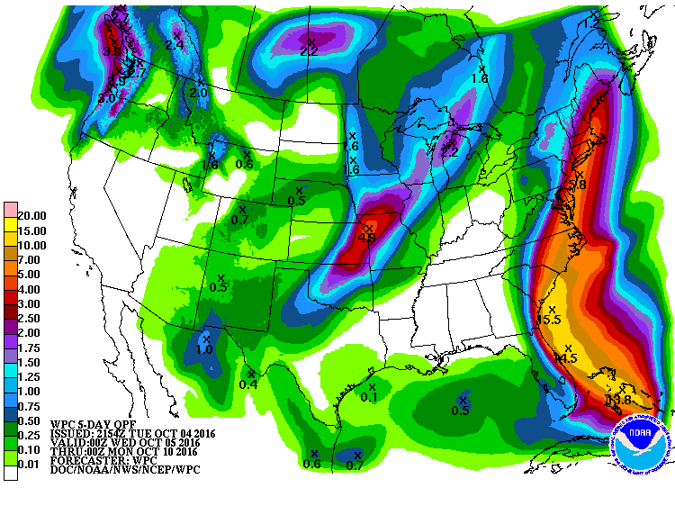
Heavy Rainfall
Here's the 5 day rainfall potential, which suggests heavier rain moving back into the Upper Midwest through the middle part of the week. Some locations could see up to an additional 1" to 2" through the end of the week.
Turning Colder Late Week
Temperatures ahead of the cold front warmer into the 70s earlier this week, but note how much cooler it gets post front by the second half of the week. I wouldn't be surprised to see widespread frost and freeze headlines by the end of the week/weekend ahead.
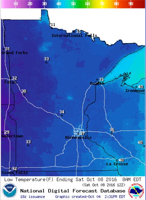
Frosty Friday Night Ahead - For Some
Take a look at the low temperatures expected across the state Friday night/AM Saturday. With lows dipping into the low to mid 30s, I could see widespread frost and freeze headlines posted later this week. Stay tuned!
_________________________________________
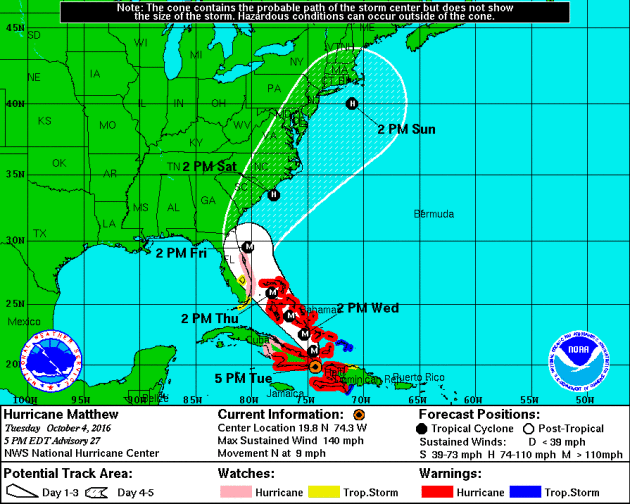
Hurricane Matthew
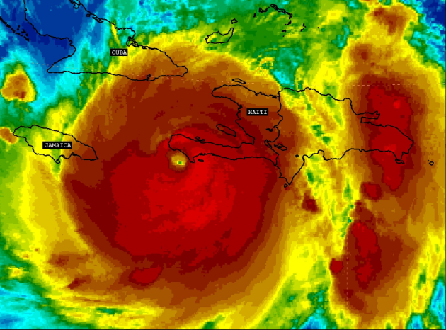
According to @NHC_Atlantic "#Matthew made landfall near Les Anglais, Haiti at 7 am EDT Tuesday. This is the first Category 4 #hurricane landfall in Haiti since Cleo in 1964." At landfall, Matthew was an extremely strong category 4 hurricane with winds sustained at 145mph!
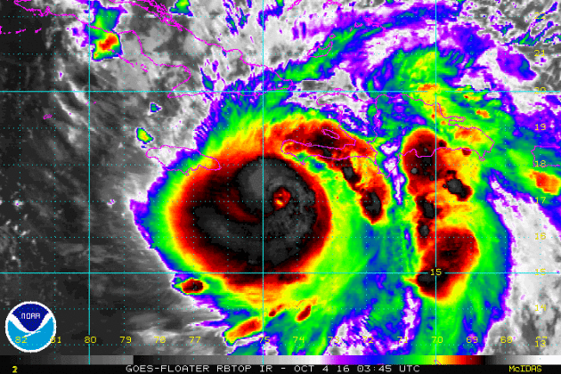
Hurricane Matthew became the 5th hurricane of the 2016 Atlantic hurricane season on Thursday of last week and strengthened rapidly into a MAJOR category 3 hurricane Friday morning. Overnight Friday, Matthew strengthened even more into a category 5 storm with sustained winds up to 160mph. Interestingly, Matthew became the first category 5 hurricane in the Atlantic Basin since Hurricane Felix in 2007. Matthew is located in the Caribbean and is expected to lift straight north this weekend toward Cuba and the Bahamas by early next week. As of AM Tuesday, Matthew continued as a strong category 4 strength with winds up to 145mph! According to the Air Force Reserve Hurricane Hunter, the eye was observed to be 14 miles wide.
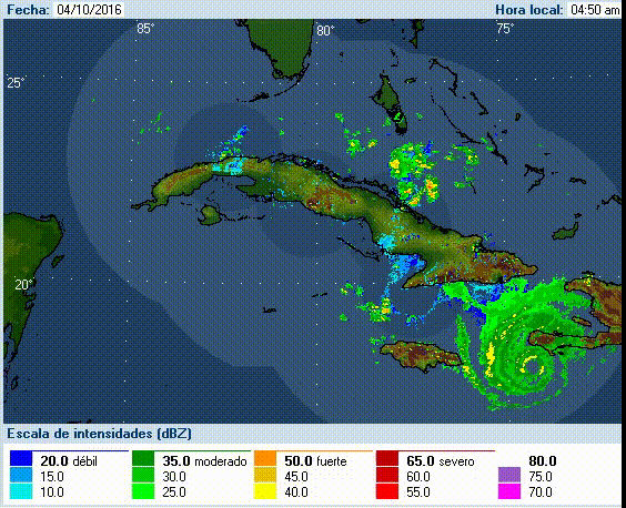
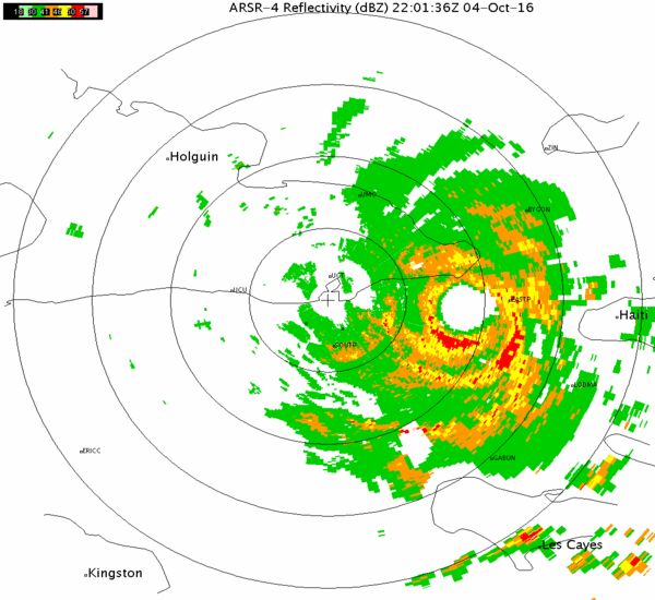
Matthew Via Radar from Cuba
This was Hurricane Matthew seen from the Cuban radar just prior to landfall in southwest Haiti AM Tuesday and just prior to landfall with eastern Cuba.
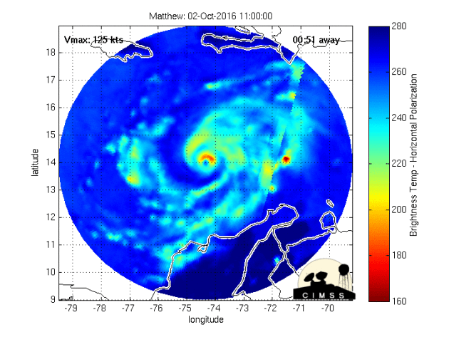
Inside the Eye of Matthew
Take a look at this image from Jessica Williams/NOAA aboard the Hurricane Hunter from Monday. According to Air Force Reserve Hurricane Hunter, the eye of Matthew was 14 miles wide!


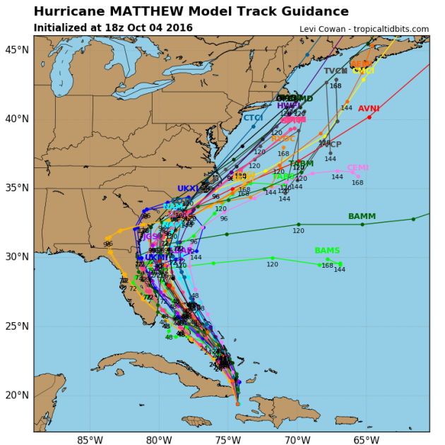
Tracking Matthew
After strengthening into a category 5 hurricane (the first in 9 years; since Felix in 2007), models project that we may still see major hurricane strength (category 3 or higher) over the next few days.
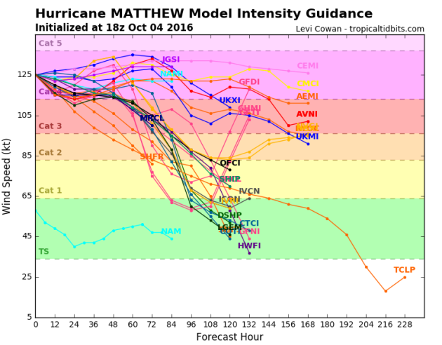
Tracking Matthew
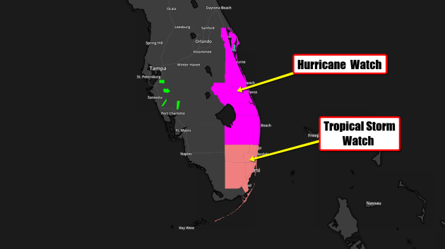
Hurricane watches and warnings have been issued for a number of locations in advance of Matthew. The official track from the National Hurricane Center suggests Matthew will continue at major hurricane strength through early and middle part of next week as it makes a close encounter with eastern Cuba and the Bahamas by the middle/end of next week as a major hurricane. Note that hurricane watches have been posted on the east side of Florida as Matthew could potentially still be a Major hurricane by PM Friday.
Hurricane Watches Posted for Florida!!
...HURRICANE WATCH IN EFFECT... THE NATIONAL WEATHER SERVICE IN MELBOURNE HAS ISSUED A HURRICANE WATCH.
* WINDS...AS MAJOR HURRICANE MATTHEW MOVES CLOSER...THE THREAT FOR SUSTAINED HIGH WINDS IS LIKELY TO INCREASE. THE LATEST FORECAST IS FOR STRONG TROPICAL FORCE WINDS FROM LATE WEDNESDAY OVERNIGHT OR EARLY THURSDAY MORNING. HURRICANE FORCE WINDS WILL BE POSSIBLE FROM LATE THURSDAY AFTERNOON INTO FRIDAY.
* WAVES/SEAS...SEAS WILL LIKELY BEGIN TO INCREASE AS EARLY AS WEDNESDAY AFTERNOON AND PEAK THURSDAY NIGHT AND FRIDAY TO 25 TO 30 FEET OFFSHORE. MARINERS ARE ADVISED TO RETURN TO PORT BY WEDNESDAY AFTERNOON AND MAKE ALL PREPARATIONS TO SECURE THEIR VESSELS.
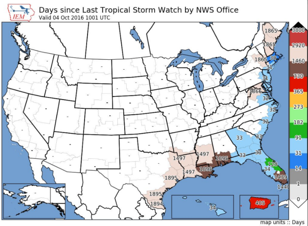
Days Since Late Tropical Watches
How about this stat! According to the @NWSKeyWest, prior to tropical watches being issued on Monday, it had been nearly 4 years since the last tropical storm watches had been issued for the Florida Keys!
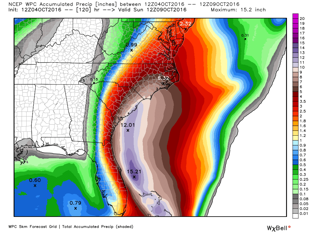
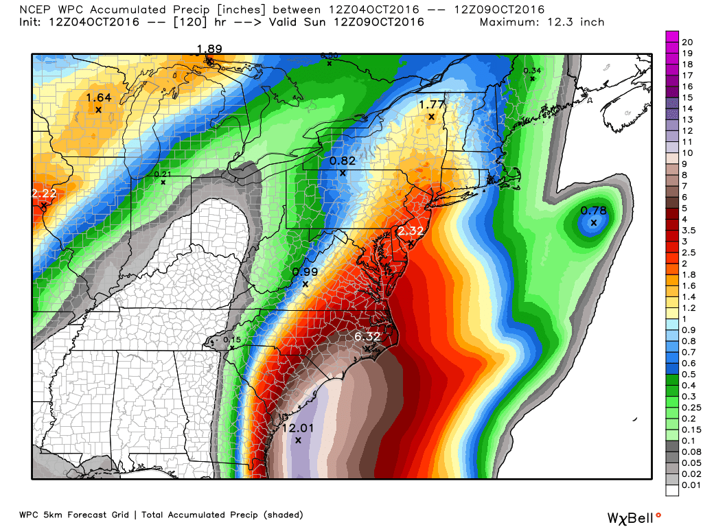
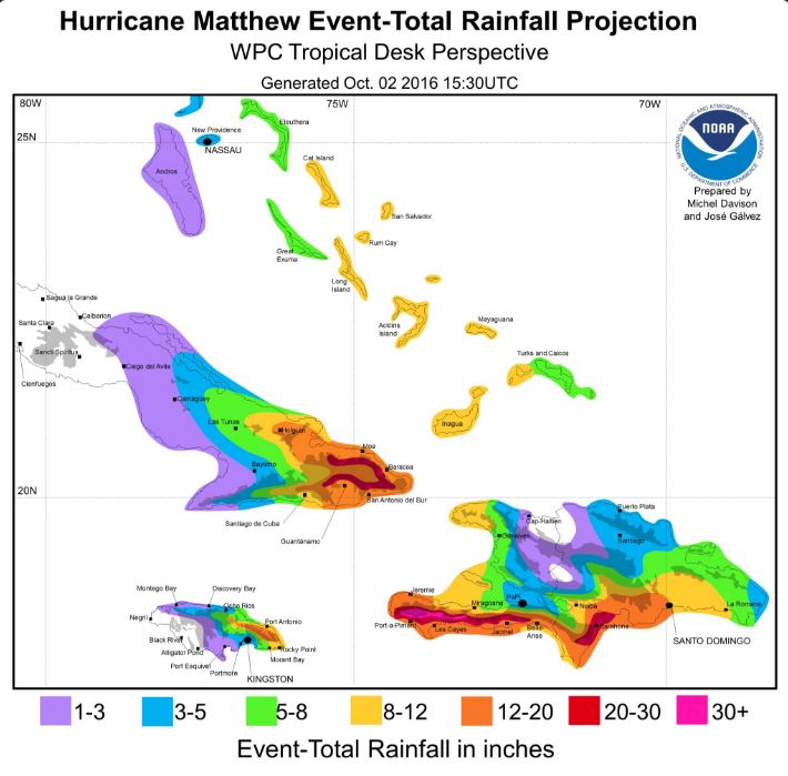
Heavy Rainfall Potential
With Matthew tracking a little farther west, heavy rainfall is now going to be a potential major issue across the East Coast. Note that some locations could see up to 3" to 6" with some significantly higher tallies possible across the east coast of North and South Carolina.
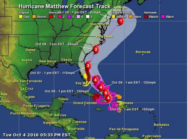
Tracking Matthew
Here are a few different model solutions for Matthew. Note that most are pretty consistent as it tracks over eastern Cuba and the Bahamas early next week. The extended forecast for mid/late week gets a little hairy as some track the system into the Eastern U.S., while others take it out into the Atlantic Ocean.
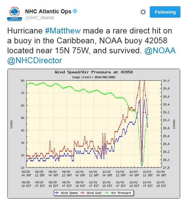
Direct Hit!
Take a look at this! Hurricane Matthew made a direct hit with a buoy located in the Caribbean and survived! Note the relation between the intense wind gusts and the central pressure dropping significantly as Matthew passed over the buoy.
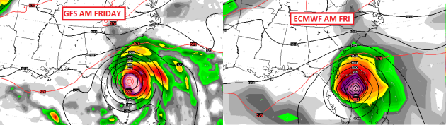
Here's the latest GFS and ECMWF track for Matthew by late week. Note that the storm looks to potentially take a very close track to the east coast of Florida and the Mid-Atlantic. Interestingly, both models seem to be pretty close together at that point!
___________________________________
Signs of fall are starting to pop a little more each and every day. Things are a little more advanced across the central and northern part of the state, but we're getting there.

________________________________
Average High/Low for Minneapolis
October 5th
 _______________________________________________________________________
___________________________________________________________
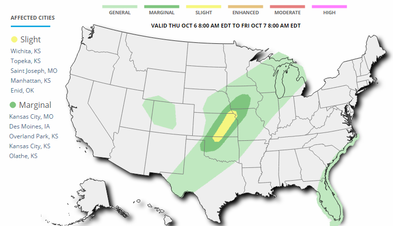
...SUMMARY... ISOLATED STRONG TO SEVERE THUNDERSTORMS ARE FORECAST FROM WESTERN PORTIONS OF OKLAHOMA NORTHEASTWARD THROUGH KANSAS AND INTO CENTRAL IOWA THURSDAY AFTERNOON AND EARLY EVENING. ...SYNOPSIS... A MID-LEVEL SPEED MAX INITIALLY OVER THE CENTRAL ROCKIES WILL MOVE INTO EASTERN NEB BY EARLY EVENING AND SUBSEQUENTLY TO THE WESTERN GREAT LAKES BY DAYBREAK FRIDAY. A COLD FRONT OVER PARTS OF THE CENTRAL PLAINS AND MIDWEST WILL BEGIN TO PUSH SOUTHWARD LATE IN THE PERIOD. A WEAK SURFACE WAVE IS EXPECTED TO DEVELOP NORTHEASTWARD ALONG THE FRONT FROM CENTRAL KS INTO NORTHERN WI. ...NWRN OK AND KS INTO NWRN MO AND CNTRL IA... THE INFLUENCE OF A SURFACE RIDGE WILL BECOME INCREASINGLY PROMINENT WITH TIME ACROSS THE APPALACHIANS INTO THE ARKLATEX. AS A RESULT...A PLUME OF RICHER MOISTURE WILL BECOME INCREASINGLY SHUNTED WESTWARD/NORTHWESTWARD ACROSS PARTS OF THE SOUTHERN-CENTRAL PLAINS AND INTO THE MIDWEST NEAR A FRONT. MODEL GUIDANCE SHOWS A NARROWING CORRIDOR OF MID 60S DEG F DEWPOINTS BUT APPRECIABLE HEATING THROUGH THE EARLY-MID AFTERNOON WILL CONTRIBUTE TO MODERATE BUOYANCY. AS THE MID-LEVEL DISTURBANCE SHEARS NORTHEASTWARD ACROSS THE CENTRAL PLAINS...THE STRONGEST FLOW WILL TEND TO BE LOCATED NORTHWEST OF THE WARM SECTOR ACROSS OK INTO PARTS OF KS. NONETHELESS...EFFECTIVE SHEAR RANGING FROM 40-KT OVER IA INTO THE MO VALLEY AND 30-KT OVER WESTERN OK WILL LIKELY PROVE SUFFICIENT FOR AN ORGANIZED BAND OR TWO OF STORMS TO DEVELOP. AN INITIAL RISK FOR SEVERE HAIL MAY DEVELOP WITH THE STRONGER UPDRAFTS BEFORE UPSCALE GROWTH OCCURS WITH THE SEVERE RISK TRANSITIONING TO GUSTY OUTFLOW WINDS.

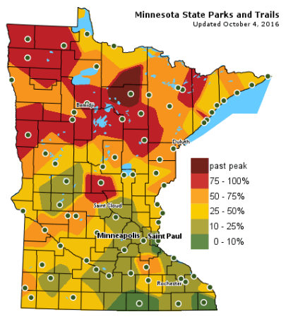
Fall Color Update
The latest update from the MN DNR shows that we are well on our way in the fall color department with some peak colors (75% - 100%) color being reported across parts of Central and Northern Minnesota. There is even a pocket of past peak across north-central Minnesota near Scenic State Park. Note that only 10% to 25% color can be found across the Twin Cities; the average peak there is generally late September to mid October.
_______________________________________________
Tracking Cooler Fronts - All Eyes on Matthew
Pick your poison: earthquakes, wildfires, long-track tornadoes, Texas-size hurricanes? Say what you will about Minnesota's climate, but all those cold fronts inoculate us from some of the worst weather on Earth. We mutter about the cold - and slip and slide on ice, but our storms rarely sweep away homes or threaten mass evacuations.
Hurricane Matthew dealt a crippling blow to Haiti, and now models pull this dangerous storm across the Bahamas- right up the east coast of Florida into the Carolinas. Matthew may leave behind a long swath of wind and wave-related coastal flooding from Palm Beach to Daytona Beach to Charleston and Norfolk.
While we cool off and ponder which jacket to try on. September 2015 was the warmest on record for Minnesota. Winter came late; the first flakes on October 28, 2015 - the first inch of now on November 26My hunch is that winter will be pushed back once again this year. I see 50s Friday & Saturday with patchy weekend frost.
And more heavy rain is possible tonight ahead of the next cool front. This year, when in doubt, just predict rain.
___________________________________________________
___________________________________________________
Extended Weather Outlook
TUESDAY NIGHT: Scattered storms, some with heavy rain. Winds: SE 15-30. Low: 58
WEDNESDAY: Wet start, then clearing. Winds: SW 10-15. High: 70
WEDNESDAY NIGHT: Partly cloudy and cooler. Winds: SSW 5mph. Low: 48
THURSDAY: Early sun, more rain arrives late. Winds: NW 5-10. Wake-up: 48. High: 67.
FRIDAY: Mostly cloudy, feels like fall. Frost up north overnight. Winds: NW 10-20. Wake-up: 44. High: 53.
SATURDAY: Some frost in the burbs. Chilled sun. Winds: NW 8-13. Wake-up: 36. High: 52.
SUNDAY: Clouds increase, turning a bit milder. Winds: S 10-15. Wake-up: 40. High: 62.
MONDAY: Lots of clouds, still a bit chilly. Winds: SW 10-15. Wake-up: 49. High: 57.
TUESDAY: Plenty of cool sunshine. Winds: W 5-10. Wake-up: 41. High: 56.
_______________________________
_______________________________
This Day in Weather History
October 5th
1963: A heat wave hits part of Minnesota with highs of 98 at Beardsley, 96 at Madison, and 94 at Elbow Lake.October 5th
________________________________
Average High/Low for Minneapolis
October 5th
Average High: 63F (Record: 8F set in 2001)
Average Low: 44F (Record: 25F set in 1952)
_________________________________
Average Low: 44F (Record: 25F set in 1952)
_________________________________
Sunrise/Sunset Times for Minneapolis
October 5th
October 5th
Sunrise: 7:16am
Sunset: 6:45pm
Sunset: 6:45pm
*Daylight Lost Since Yesterday: ~3mins & 5sec
*Daylight Lost Since Summer Solstice: ~4hours and 8mins
______________________________________________________________________
*Daylight Lost Since Summer Solstice: ~4hours and 8mins
______________________________________________________________________
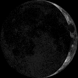
Moon Phase for October 5th at Midnight
2.9 Days Before First Quarter
2.9 Days Before First Quarter
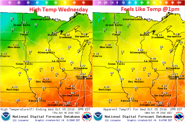
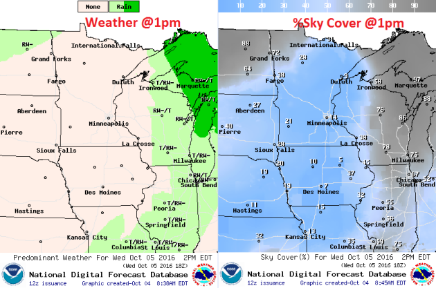
Weather Outlook Wednesday
High temperatures on Wednesday will start cooling down post front. Note that readings will still be close to 70F across the southern part of the state, but note the much cooler air lurking across northern Minnesota with highs only in the 50s!
Weather Outlook Wednesday
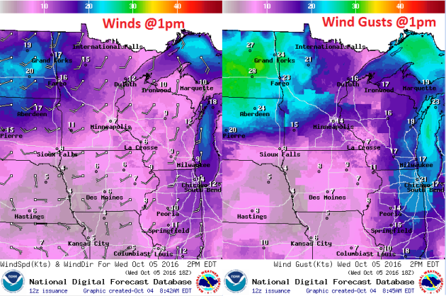
Winds on Wednesday won't be quite as strong as they were on Tuesday, however, it'll still be breezy. Winds will turn out of a more westerly direction, which will be a bit of a cooler wind and with wind gusts approaching 25mph+ across the northwestern part of the state, it'll fee even cooler there.
Weather Outlook Wednesday
After heavy rainfall overnight Tuesday/early Wednesday, it looks like we clear out pretty decently on Wednesday just behind the cold front. Enjoy it because clouds and rain return on Thursday with MUCH cooler temperatures later this week.
___________________________________________________________
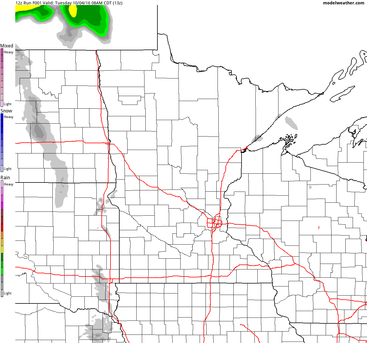
Simulated Radar
The simulated radar from Monday to Wednesday shows mostly dry weather continuing across the region Monday with weather conditions souring a bit Tuesday as a line of showers and storms moves in. Some of the rain could be heavy at times Tuesday night/AM Wednesday.
Rainfall Potential
Rainfall potential through midday Friday suggests scattered showers and storms moving into the state PM Tuesday with locally heavy rainfall potential. Another round of showers moves in on Thursday. Some spots could see 1" to nearly 2" or more through the end of the week.
_________________________________________
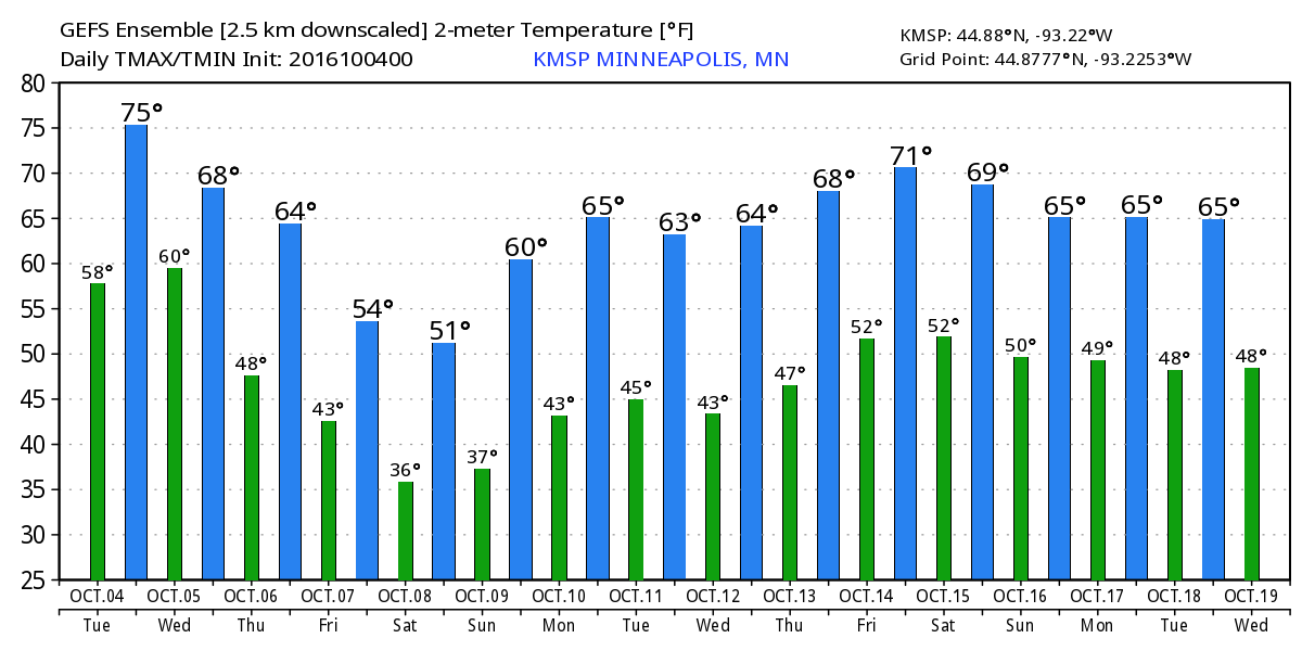
Extended Weather Outlook
The extended temperature outlook over the next 16 days suggests temperatures warming to near 70F through Tuesday before a fairly significant cold front sweeps through by the middle/end of next week. High temperatures by the second of October looks to be potentially very chilly. Note that low temperatures AM Saturday will likely dip into the 30s!
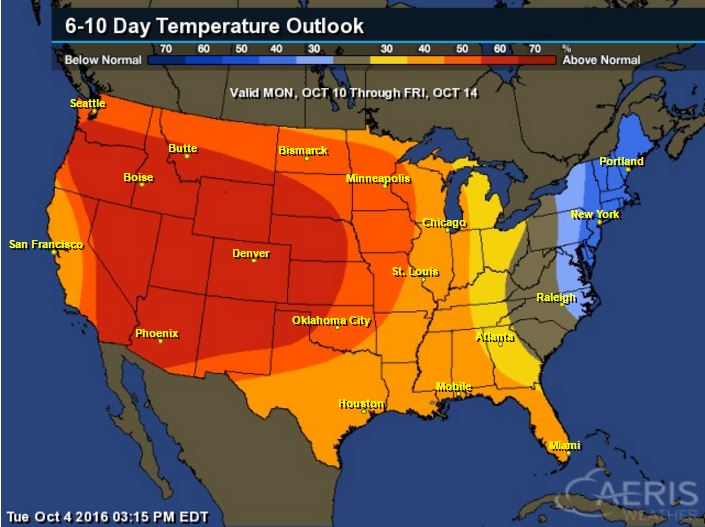
6 to 10 Day Temp Outlook
Here's the national temperature outlook from October10th - 14th, which shows warmer than average conditions across the western half of the nation after much below average temperatures and snowfall this week.
__________________________________________
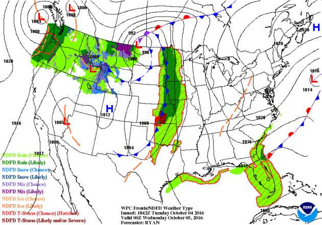
National Weather Outlook
The storm system that produced heavy snowfall across of the high elevations earlier this week will push north into Canada allowing cold air to funnel south into the Lower 48. Note that another system looks to develop across the Central U.S. later with week with another surge of heavy moisture moving into the Upper Midwest. Also note Matthew moving along the Florida coast later this week.
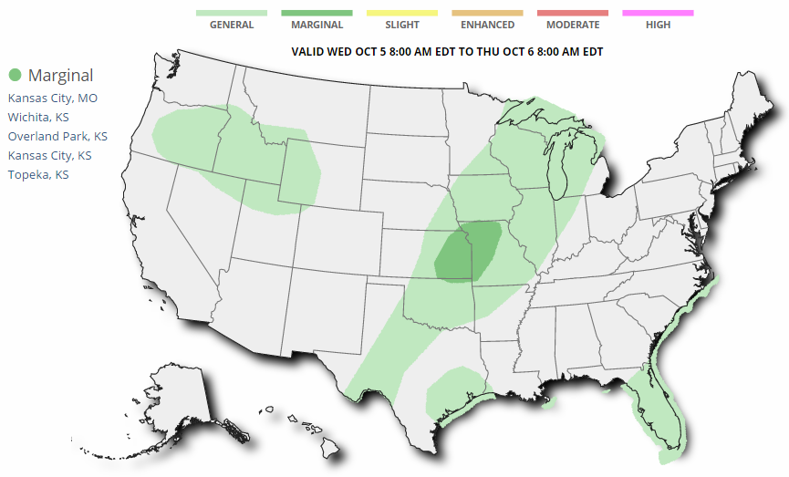
Severe Threat Wednesday
...SUMMARY... ISOLATED STRONG TO SEVERE THUNDERSTORMS CAPABLE OF HAIL AND WIND ARE POSSIBLE FROM EASTERN KANSAS INTO WESTERN MISSOURI AND NORTHEAST OKLAHOMA. ...SYNOPSIS... AN UPPER LOW WILL REMAIN OVER S CNTRL CANADA WITH A NEGATIVELY TILTED SHORTWAVE TROUGH PIVOTING NEWD ACROSS THE UPPER MS VALLEY AND GREAT LAKES. TO THE SW...A BROAD AREA OF CYCLONIC FLOW ALOFT WILL STRETCH FROM THE PLAINS INTO THE ROCKIES AND GREAT BASIN WITH A SPEED MAX OVER THE FOUR CORNERS AREA. AT THE SFC...A PRIMARY LOW WILL MOVE INTO ONTARIO WITH A SFC TROUGH EXTENDING SWWD ACROSS THE UPPER MS VALLEY AND INTO THE CNTRL PLAINS WHERE A SECONDARY WEAKER LOW WILL EXIST OVER KS. MEANWHILE...HIGH PRESSURE WILL ENCOMPASS MUCH OF THE ERN STATES CENTERED OVER NEW ENGLAND WITH RIDGE AXIS EXTENDING SWWD INTO TX. SLY SFC WINDS AROUND THE HIGH WILL MAINTAIN A PLUME OF MID TO UPPER 60S F DEWPOINTS FROM THE SRN PLAINS INTO THE MID MO VALLEY. AREA OF STORMS ARE LIKELY TO OCCUR NEAR THE SFC TROUGH WHERE A MOIST AND UNSTABLE AIR MASS WILL EXIST...WITH FAVORABLE WIND SHEAR HELPING TO PRODUCE A FEW STRONG TO SEVERE STORMS MAINLY LATE.
Severe Threat Thursday
...SUMMARY... ISOLATED STRONG TO SEVERE THUNDERSTORMS ARE FORECAST FROM WESTERN PORTIONS OF OKLAHOMA NORTHEASTWARD THROUGH KANSAS AND INTO CENTRAL IOWA THURSDAY AFTERNOON AND EARLY EVENING. ...SYNOPSIS... A MID-LEVEL SPEED MAX INITIALLY OVER THE CENTRAL ROCKIES WILL MOVE INTO EASTERN NEB BY EARLY EVENING AND SUBSEQUENTLY TO THE WESTERN GREAT LAKES BY DAYBREAK FRIDAY. A COLD FRONT OVER PARTS OF THE CENTRAL PLAINS AND MIDWEST WILL BEGIN TO PUSH SOUTHWARD LATE IN THE PERIOD. A WEAK SURFACE WAVE IS EXPECTED TO DEVELOP NORTHEASTWARD ALONG THE FRONT FROM CENTRAL KS INTO NORTHERN WI. ...NWRN OK AND KS INTO NWRN MO AND CNTRL IA... THE INFLUENCE OF A SURFACE RIDGE WILL BECOME INCREASINGLY PROMINENT WITH TIME ACROSS THE APPALACHIANS INTO THE ARKLATEX. AS A RESULT...A PLUME OF RICHER MOISTURE WILL BECOME INCREASINGLY SHUNTED WESTWARD/NORTHWESTWARD ACROSS PARTS OF THE SOUTHERN-CENTRAL PLAINS AND INTO THE MIDWEST NEAR A FRONT. MODEL GUIDANCE SHOWS A NARROWING CORRIDOR OF MID 60S DEG F DEWPOINTS BUT APPRECIABLE HEATING THROUGH THE EARLY-MID AFTERNOON WILL CONTRIBUTE TO MODERATE BUOYANCY. AS THE MID-LEVEL DISTURBANCE SHEARS NORTHEASTWARD ACROSS THE CENTRAL PLAINS...THE STRONGEST FLOW WILL TEND TO BE LOCATED NORTHWEST OF THE WARM SECTOR ACROSS OK INTO PARTS OF KS. NONETHELESS...EFFECTIVE SHEAR RANGING FROM 40-KT OVER IA INTO THE MO VALLEY AND 30-KT OVER WESTERN OK WILL LIKELY PROVE SUFFICIENT FOR AN ORGANIZED BAND OR TWO OF STORMS TO DEVELOP. AN INITIAL RISK FOR SEVERE HAIL MAY DEVELOP WITH THE STRONGER UPDRAFTS BEFORE UPSCALE GROWTH OCCURS WITH THE SEVERE RISK TRANSITIONING TO GUSTY OUTFLOW WINDS.
Precipitation Outlook
The heaviest rainfall over the next few days will once again develop across the Central U.S. as our next storm system moves in. There will also be heavier precipitation across the Northwest. Also note the heavy precipitation along the East Coast, this is associated with "Matthew".
___________________________________________
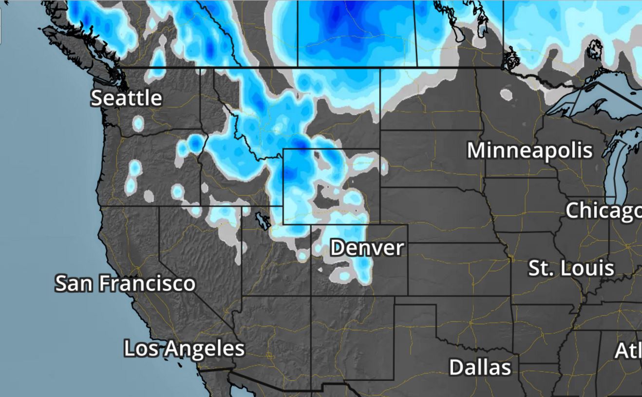
Snowfall Potential
As the storm system continues to push east, snow will linger across the higher elevations of the Central and Northern Rockies. Interestingly, note that there may even be a little snow in the lower elevations along the Front Range and across eastern Montana and parts of northern North Dakota!
__________________________________________________________________
Thanks for checking in and don't forget to follow me on Twitter @TNelsonWX
No comments:
Post a Comment