Snow in the Mountains
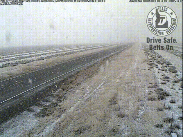
Thanks to the @NWSMissoula for this post from Gilmore Summit in Idaho Monday. This snow is from the same storm system that will bring scattered showers and storms to Minnesota Tuesday/AM Wednesday.
 5 Day Snowfall Forecast
As the storm system works inland, moisture will turn to snow across the higher elevations from the Sierra Nevada Range to the Colorado Rockies. There may even be a little snow in the lower elevations along the Front Range.
___________________________________________
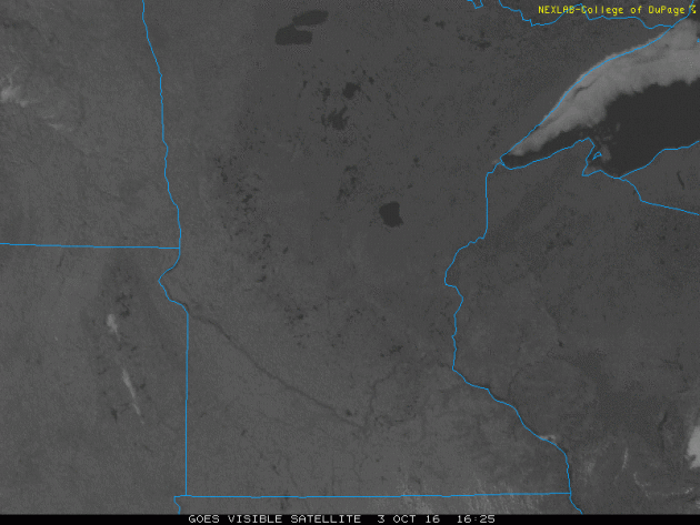
Monday Sunshine
Monday was a beautiful day with mostly sunny skies and a stronger breeze that kicked up in the afternoon. Ultimately, it helped to bump temperatures up into the low to mid 70s across the state.
 Monday Sunshine
Here's the visible satellite loop from Monday, which showed mostly clear skies across the state. Note the low clouds and fog that slithered along the western side of Lake Superior. Also note the high clouds that were moving across the eastern Dakotas, these are the clouds associated with the storm system that will bring widespread showers and storms to the region Tuesday/AM Wednesday.
Thanks to the @NWSMissoula for this post from Gilmore Summit in Idaho Monday. This snow is from the same storm system that will bring scattered showers and storms to Minnesota Tuesday/AM Wednesday.
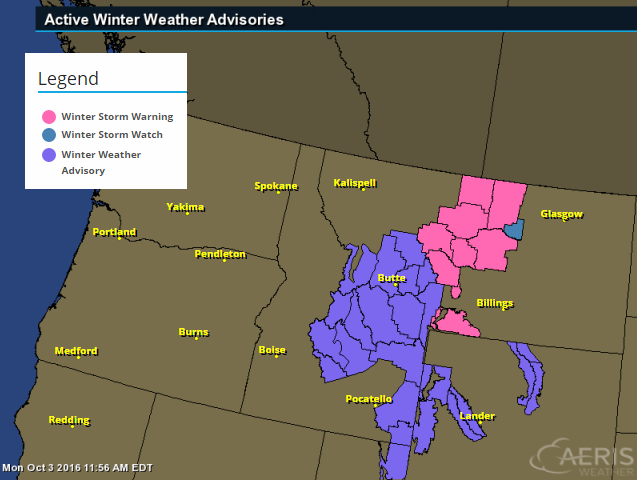
Winter Weather Headlines
Winter Storm Warnings and Winter Weather Advisories have been posted for parts of the Central and Northern Rockies through Tuesday as heavy snow falls across mountains.
* SNOW LEVEL...LOWERING TO AROUND 5000 FEET.
* SNOW ACCUMULATIONS...1 TO 4 INCHES NEAR THE FOOTHILLS AND 5 TO 14 INCHES ABOVE 6000 FEET.
* TIMING...RAIN WILL SWITCH TO SNOW DURING THE AFTERNOON AND EVENING HOURS. PERIODS OF SNOW WILL CONTINUE THROUGH THE DAY ON TUESDAY.
* IMPACTS...HEAVY WET SNOW COULD CAUSE HAZARDOUS CONDTIONS.
* WINDS...NORTHWEST 15 TO 25 MPH...WITH GUSTS UP TO 40 MPH.
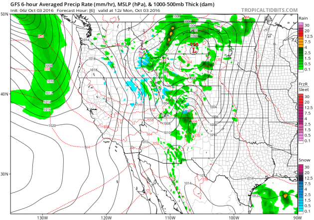
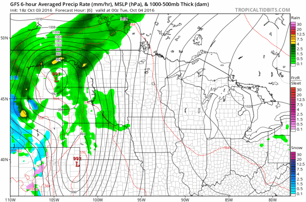
Western Storm System
The next storm system is forecast to move into the Western U.S. with some gusto by this weekend and early next week. Gusty winds, colder temps and high elevation snow will be possible. Interestingly, this storm will bring chances of widespread rain/thunder to the Upper Midwest by the middle part of next week.
As the storm system works inland, moisture will turn to snow across the higher elevations from the Sierra Nevada Range to the Colorado Rockies. There may even be a little snow in the lower elevations along the Front Range.
___________________________________________
Monday was a beautiful day with mostly sunny skies and a stronger breeze that kicked up in the afternoon. Ultimately, it helped to bump temperatures up into the low to mid 70s across the state.
Here's the visible satellite loop from Monday, which showed mostly clear skies across the state. Note the low clouds and fog that slithered along the western side of Lake Superior. Also note the high clouds that were moving across the eastern Dakotas, these are the clouds associated with the storm system that will bring widespread showers and storms to the region Tuesday/AM Wednesday.
_______________________________________________
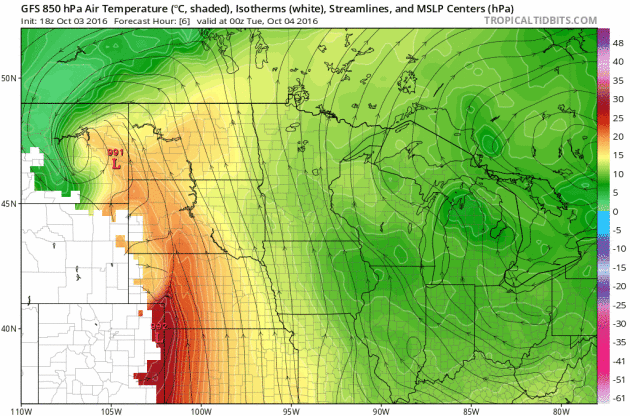
Storm System This Week
A storm system brewing in the Western U.S. will move into the Upper Midwest by the middle part of the week with scattered showers and storms along the cold front. Heavier rainfall potential may be possible along the cold front as it moves through the Mississippi River Valley. Note that temperatures may even be cold enough for snow potential across NW North Dakota.
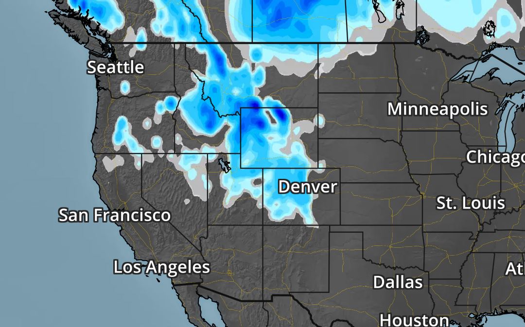
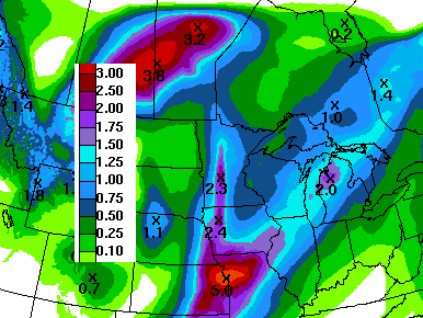
Heavy Rainfall Potential Returns
Here's the 7 day rainfall potential, which suggests heavier rain possibly moving back into the Upper Midwest by the middle part of the week. Some locations could see up to an additional 1" to 2" through next weekend.
Turning Colder Next Week
Temperatures ahead of the cold front will warm into the 70s through the early part of next week, but note how much cooler it gets post front by the middle/end of next week. I wouldn't be surprised to see more frost and freeze concerns develop by the end of next week.
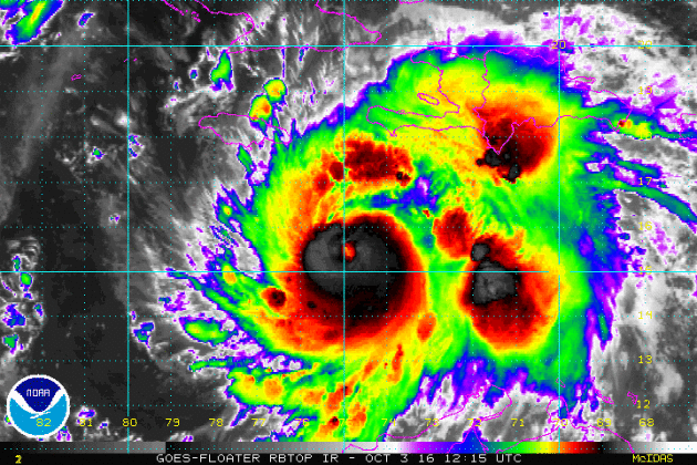
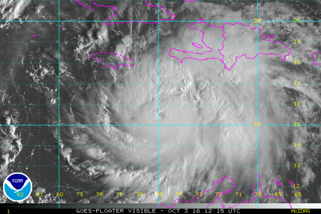
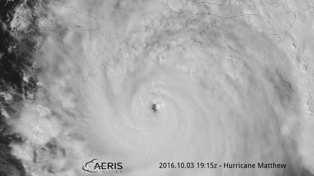
Hurricane Matthew
Hurricane Matthew became the 5th hurricane of the 2016 Atlantic hurricane season on Thursday of last week and strengthened rapidly into a MAJOR category 3 hurricane Friday morning. Overnight Friday, Matthew strengthened even more into a category 5 storm with sustained winds up to 160mph. Interestingly, Matthew became the first category 5 hurricane in the Atlantic Basin since Hurricane Felix in 2007. Matthew is located in the Caribbean and is expected to lift straight north this weekend toward Cuba and the Bahamas by early next week. As of Monday, Matthew continued at category 4 strength with winds up to 140mph! According to the Air Force Reserve Hurricane Hunter, the eye was observed to be 14 miles wide.
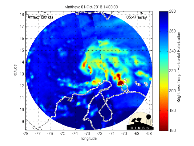
Inside the Eye of Matthew
Take a look at this image from Jessica Williams/NOAA aboard the Hurricane Hunter from Monday. According to Air Force Reserve Hurricane Hunter, the eye of Matthew was 14 miles wide!

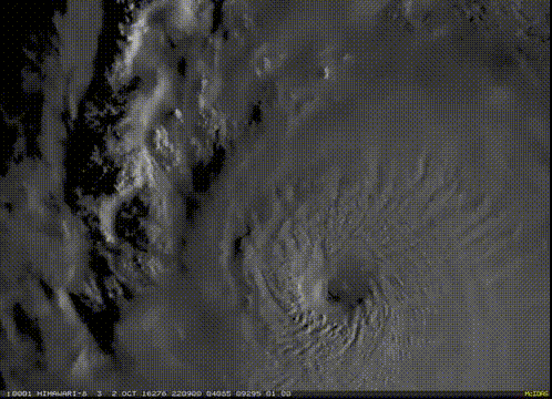
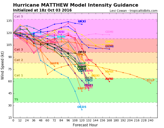
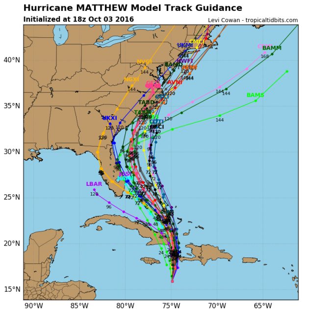
Tracking Matthew
After strengthening into a category 5 hurricane (the first in 9 years; since Felix in 2007), models project that we may still see major hurricane strength (category 3 or higher) over the next few days.
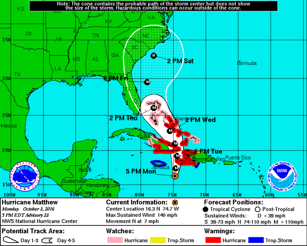
Tracking Matthew
Hurricane watches and warnings have been issued for a number of locations in advance of Matthew. The official track from the National Hurricane Center suggests Matthew will continue at major hurricane strength through early and middle part of next week as it makes a close encounter with Jamaica, Haiti and slides over eastern Cuba. Note that the the northerly track takes it over the Bahamas by the middle/end of next week as a major hurricane.
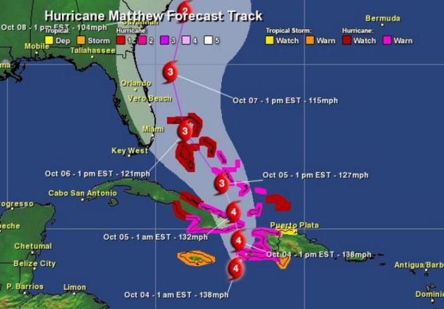
Here are a few different model solutions for Matthew. Note that most are pretty consistent as it tracks over eastern Cuba and the Bahamas early next week. The extended forecast for mid/late week gets a little hairy as some track the system into the Eastern U.S., while others take it out into the Atlantic Ocean.
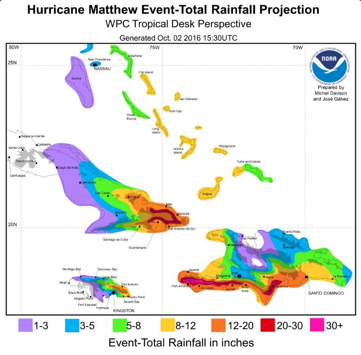
Incredible Rainfall Potential
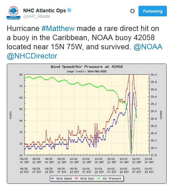
Direct Hit!
Take a look at this! Hurricane Matthew made a direct hit with a buoy located in the Caribbean and survived! Note the relation between the intense wind gusts and the central pressure dropping significantly as Matthew passed over the buoy.
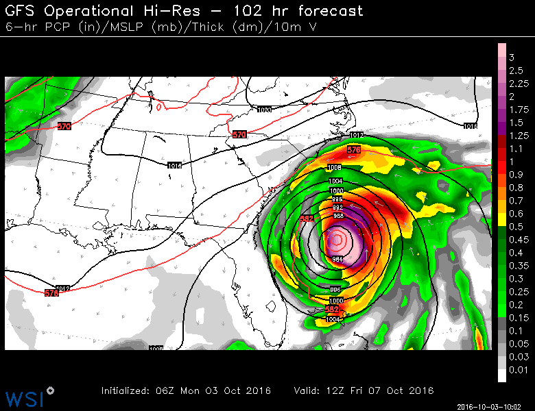
Here's the latest GFS track for Matthew by late week. Note that the storm looks to potentially take a very close track to the east coast of Florida and the Mid-Atlantic.
___________________________________
Signs of fall are starting to pop a little more each and every day. Things are a little more advanced across the central and northern part of the state, but we're getting there.

1939: A storm dumps 2.16 inches of rain at Fairmont.
1922: A record high of 89 is set in Minneapolis.
________________________________
Average High/Low for Minneapolis
October 4th
 _______________________________________________________________________
___________________________________________________________
...SWRN MN/NWRN IA... WEAK INSTABILITY WILL DEVELOP AHEAD OF THE SFC TROUGH DURING THE DAY AS WARM ADVECTION BRINGS LOWER 60S F DEWPOINTS NWD AHEAD OF THE UPPER TROUGH. FORECAST SOUNDINGS SHOW LARGE LOOPING HODOGRAPHS WHICH MAY SUPPORT ROTATING STORMS WITH EVOLVING EARLY AND LATE ACTIVITY. THERMODYNAMIC PROFILES WILL BE RATHER MOIST AS WELL WHICH MAY SUPPORT A WEAK TORNADO...BUT THE LIMITING FACTOR WILL BE THE WEAK INSTABILITY. GIVEN THIS CONDITIONAL THREAT...HAVE EXPANDED THE MARGINAL RISK NWD INTO MN.
...DISCUSSION... THE POTENTIAL FOR ORGANIZED SEVERE THUNDERSTORMS WILL LIKELY FOCUS DURING THURSDAY /DAY 4/ FROM PARTS OF OK NORTHEASTWARD INTO THE LOWER MO VALLEY. DETERMINISTIC AND ENSEMBLE MODEL DATA SUGGEST A SHARP GRADIENT BETWEEN THE WEAK FLOW ASSOCIATED WITH THE SUBTROPICAL/TROPICAL REGIME OVER THE SOUTHEASTERN STATES AND THE WESTERLIES. THE MOST LIKELY OVERLAPPING OF THE MOIST/UNSTABLE CONDITIONS AND STRONGER WIND PROFILES WILL OCCUR ON THE NORTHWESTERN PERIPHERY OF A WARM SECTOR ACROSS THE SOUTHERN-CENTRAL PLAINS INTO THE MID MS VALLEY REGION. FROM FRIDAY /DAY 5/ INTO EARLY THE FOLLOWING WORK WEEK...MODELS INDICATE A LOWER AMPLITUDE FLOW REGIME WILL PREVAIL ACROSS THE CONUS...LENDING LOW POTENTIAL FOR CONCENTRATED AREAS OF ORGANIZED SEVERE THUNDERSTORMS.
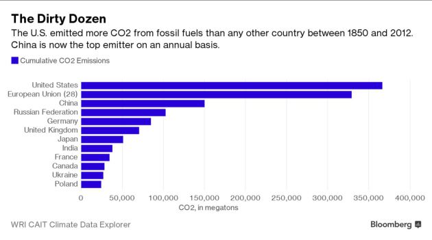
Events are conspiring to make Clinton or Trump the most powerful player in the effort to slow global warming. For a relatively slow-burning phenomenon, climate change is having a moment of great consequence this week. A cascade of events—physical, legal, political, and diplomatic—is underway. While you wouldn’t know it from the cacophony of the presidential campaign, these dramatic changes may allow the winner to dictate what direction the world heads in, for better or worse, when it comes to fighting global warming. First off, this year is expected to smash the global average heat record, set last year, which eclipsed the mark set the year before. Each decade since the 1980s has been hotter than the previous one. (Scientists explain the human contribution like this.) Second only to temperature, climate risk is most commonly represented by a single number: The amount of atmospheric carbon dioxide. Humanity has increased the CO2 level by 43 percent since industrialization in the mid-19th century. This fall, the CO2 level crossed a symbolic threshold for good—400 parts per million. For the uninitiated, take any volume of atmospheric gas, divide it into a million parts, and there will be enough CO2 to make up more than 400 of them. It may not seem like a lot, but it’s the highest level in at least 800,000 years. The period right before industrialization averaged about 280 ppm.
See more from Bloomberg.com HERE

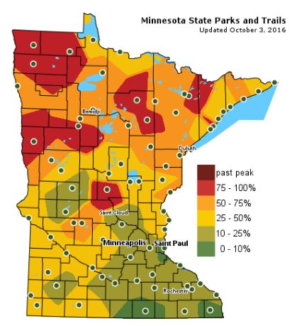
Fall Color Update
The latest update from the MN DNR shows that we are well on our way in the fall color department with some peak colors (75% - 100%) color being reported across parts of Central and Northwestern Minnesota. Note that only 10% to 25% color can be found across the Twin Cities; the average peak there is generally late September to mid October.
_______________________________________________
Stunning Stretch of Weather Comes To An End
Considering there could have been snow flurries for the Ryder Cup I consider the last week of weather nothing short of extraordinary - a stunning atmospheric exclamation point - a reminder of how
good September can be.
good September can be.
According to climate guru Mark Seeley September 2016 was among the 15 percent of warmest Septembers dating back to 1895. "Last year produced the warmest September in state history, while 2004, 2005, 2009, and 2013 were among the warmest ten Septembers in history as well" Seeley reports. Last month was wetter than average (no kidding); as much as 5X wetter over southern Minnesota.
Clouds increase Tuesday; the next frontal passage squeezing out heavy rain Tuesday night. A reinforcing cold front arrives Thursday night with more showers. Jackets will be required for Friday football games. Highs struggle to reach 50F Saturday with a little frost possible up north.
Remind me not to whine about the chill. Hurricane Matthew will flood Haiti and the Bahamas with 20-30" of rain before nearing Florida and the Carolinas by late week.
___________________________________________________
___________________________________________________
Extended Weather Outlook
MONDAY NIGHT: Increasing clouds. Winds: SE 10. Low: 58.
TUESDAY: Breezy with scattered storms later. Winds: SE 15-30. High: 73
TUESDAY NIGHT: Scattered storms, some with heavy rain. Winds: SE 15-30. Low: 57
WEDNESDAY: Soggy start, then clearing. Winds: SW 10-15. High: 68
THURSDAY: Sunny start, a little rain later. Winds: NW 10-15. Wake-up: 49. High: 65.
FRIDAY: Partly sunny and brisk. Frost up north overnight. Winds: NW 10-15. Wake-up: 45. High: 56.
SATURDAY: AM Frost up north. Patchy clouds. Winds: NNE 8-13. Wake-up: 39. High: 52.
SUNDAY: More sun, breezy and milder Winds: S 10-15. Wake-up: 38. High: 63.
MONDAY: Fading sun, mild breeze lingers. Winds: SW 10-15. Wake-up: 43. High: 71.
_______________________________
_______________________________
This Day in Weather History
October 4th
2005: Widespread heavy rain falls in Minnesota. 4.61 inches of rain falls in the Minneapolis area, 3.42 inches is recorded in St. Cloud, 2.28 inches in Redwood Falls, 2.98 inches in New London, and 3.23 inches in Buffalo.October 4th
1939: A storm dumps 2.16 inches of rain at Fairmont.
1922: A record high of 89 is set in Minneapolis.
________________________________
Average High/Low for Minneapolis
October 4th
Average High: 64F (Record: 89F set in 1922)
Average Low: 44F (Record: 24F set in 1935)
_________________________________
Average Low: 44F (Record: 24F set in 1935)
_________________________________
Sunrise/Sunset Times for Minneapolis
October 4th
October 4th
Sunrise: 7:15am
Sunset: 6:47pm
Sunset: 6:47pm
*Daylight Lost Since Yesterday: ~3mins & 5sec
*Daylight Lost Since Summer Solstice: ~4hours and 5mins
______________________________________________________________________
*Daylight Lost Since Summer Solstice: ~4hours and 5mins
______________________________________________________________________
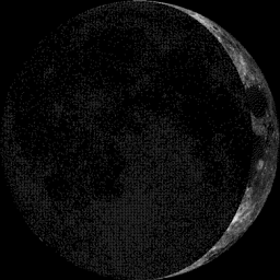
Moon Phase for October 4th at Midnight
3.9 Days Before First Quarter
3.9 Days Before First Quarter
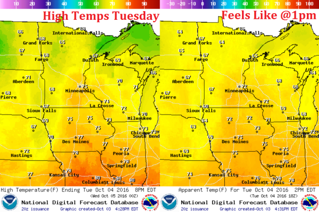
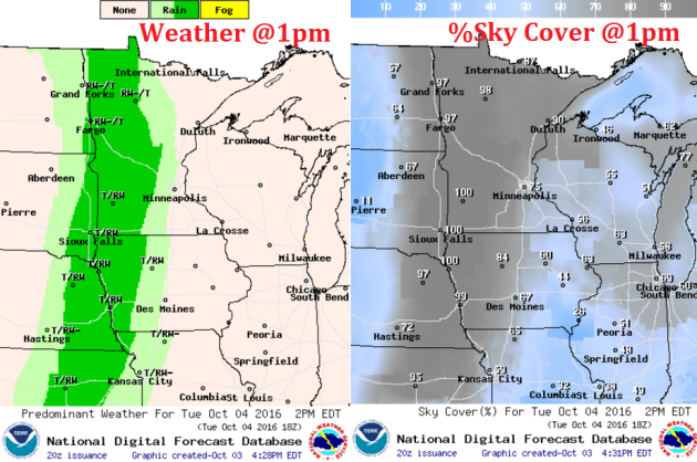
Weather Outlook Tuesday
High temperatures on Tuesday will be above once again ahead of the cold front. Some spots across the southeastern corner of the state could reach the mid 70s, while places across the northern half of the state will hold steady in the 60s.
Weather Outlook Tuesday
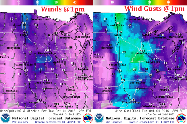
Winds on Tuesday will be even breezier than they were on Monday. Note that sustained winds will be around 10 to 20mph with gusts up to 25mph or more.
Weather Outlook Tuesday
Scattered showers and storms will fire up along the cold front as it slowly pushes east. Note that the line of showers and storms will be fairly narrow, but this narrow line could produce heavier pockets of rain through AM Wednesday.
___________________________________________________________
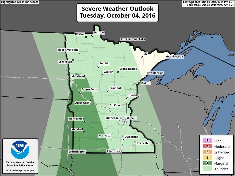
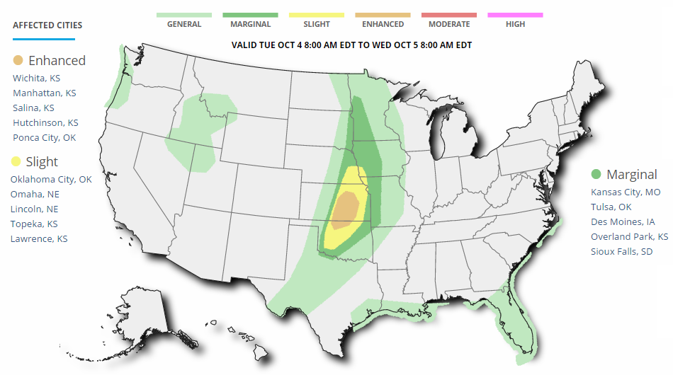
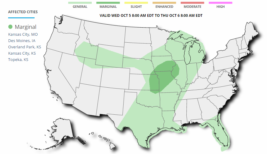
Severe Threat Tuesday
According to NOAA's SPC, there is a MARGINAL RISK of severe weather across western Minnesota for the potential of gusty winds and large hail as the line of storms develops during the afternoon/evening hours.
...SWRN MN/NWRN IA... WEAK INSTABILITY WILL DEVELOP AHEAD OF THE SFC TROUGH DURING THE DAY AS WARM ADVECTION BRINGS LOWER 60S F DEWPOINTS NWD AHEAD OF THE UPPER TROUGH. FORECAST SOUNDINGS SHOW LARGE LOOPING HODOGRAPHS WHICH MAY SUPPORT ROTATING STORMS WITH EVOLVING EARLY AND LATE ACTIVITY. THERMODYNAMIC PROFILES WILL BE RATHER MOIST AS WELL WHICH MAY SUPPORT A WEAK TORNADO...BUT THE LIMITING FACTOR WILL BE THE WEAK INSTABILITY. GIVEN THIS CONDITIONAL THREAT...HAVE EXPANDED THE MARGINAL RISK NWD INTO MN.
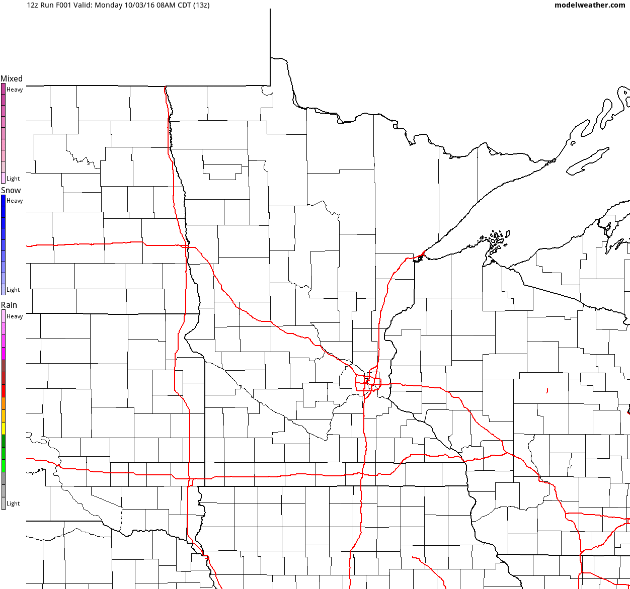
Simulated Radar
The simulated radar from Monday to Wednesday shows mostly dry weather continuing across the region Monday with weather conditions souring a bit Tuesday as a line of showers and storms moves in. Some of the rain could be heavy at times Tuesday night/AM Wednesday.
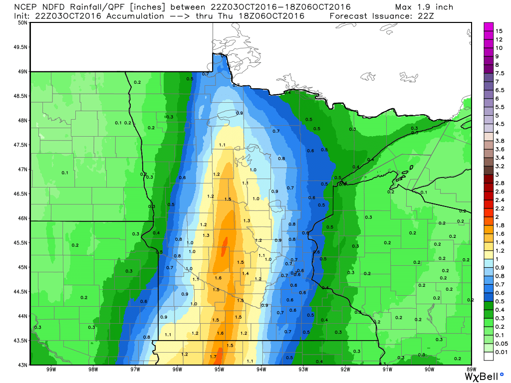
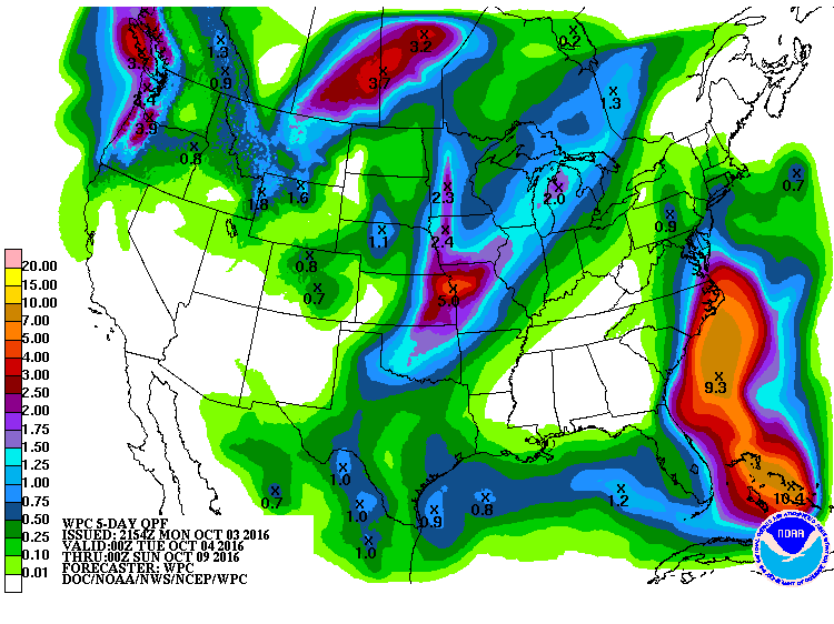
Rainfall Potential
Rainfall potential through midday Thursday suggests scattered showers and storms moving into the state by PM Tuesday with locally heavy rainfall potential. Some spots could see 1" to nearly 2" or more through midweek.
_________________________________________
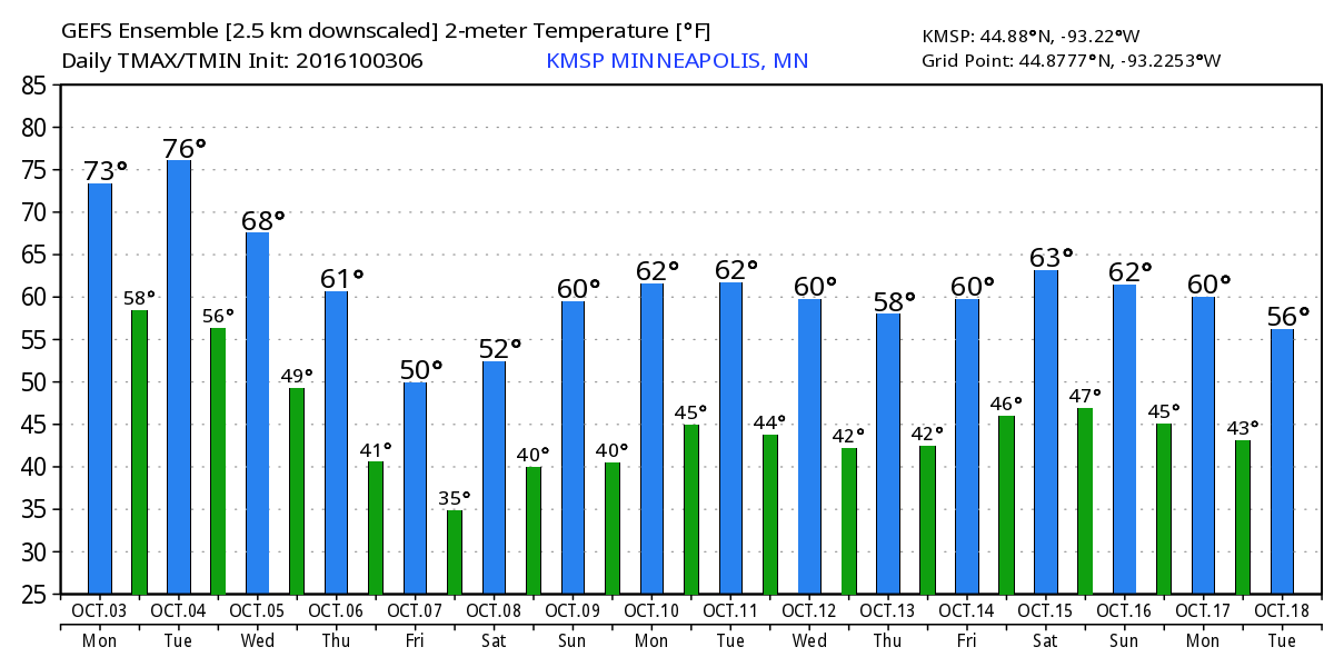
Extended Weather Outlook
The extended temperature outlook over the next 16 days suggests temperatures warming to near 70F through Tuesday before a fairly significant cold front sweeps through by the middle/end of next week. High temperatures by the second of October looks to be potentially very chilly. Note that low temperatures AM Saturday will likely dip into the 30s!
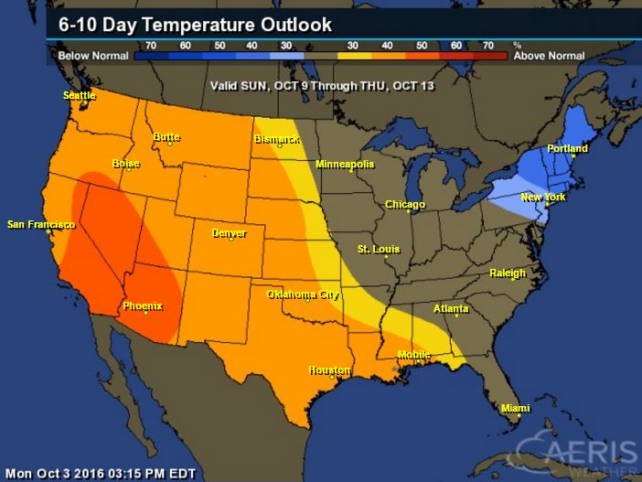
6 to 10 Day Temp Outlook
Here's the national temperature outlook from October 9th - 13th, which shows warmer than average conditions across the western half of the nation after much below average temperatures and snowfall this week.
__________________________________________
National Weather Outlook
The next storm system will move into the Central U.S. with scattered showers and storms by midweek. Prior to that, parts of the Intermountain West will see mountain snow.
Severe Weather Concerns Tuesday
...SUMMARY... SEVERE THUNDERSTORMS ARE EXPECTED OVER PARTS OF THE CENTRAL PLAINS FROM TUESDAY AFTERNOON THROUGH EARLY EVENING...WITH THE MAIN THREAT AREA CENTERED FROM NORTHERN OKLAHOMA INTO EASTERN KANSAS. LARGE HAIL IS LIKELY...ALONG WITH A FEW TORNADOES. MORE ISOLATED ACTIVITY IS ALSO POSSIBLE INTO WESTERN MINNESOTA AND EASTERN SOUTH DAKOTA WITH MARGINAL HAIL OR WIND. ...SYNOPSIS... A POTENT SHORTWAVE DISTURBANCE WILL SPREAD EWD ACROSS THE CNTRL PLAINS WITH INCREASING WIND SHEAR AND COOLING ALOFT. AT THE SFC...THE PRIMARY LOW WILL BE OVER NWRN ND BUT A SFC TROUGH WITH WEAK WIND SHIFT WILL EXTEND FROM THE MID MO RIVER VALLEY SWWD INTO WRN OK. SLY WINDS WILL BRING MID 60S F DEWPOINTS NWD TOWARD THE SFC TROUGH WHERE MODERATE INSTABILITY WILL DEVELOP WITH CENTROID OVER NRN OK INTO KS. A 40+ KT LOW-LEVEL JET WILL REMAIN IN PLACE THROUGH THE PERIOD AND WILL SUPPORT SUPERCELLS CAPABLE OF VERY LARGE HAIL AND A FEW TORNADOES MAINLY FROM NRN OK INTO KS. TO THE N...A SEPARATE UPPER DISTURBANCE WILL AFFECT THE DAKOTAS INTO MN...AND MAY SUPPORT A FEW STRONG STORMS THERE AS WELL LATER IN THE DAY WHEN INSTABILITY INCREASES AND SHEAR WITH THE LOW-LEVEL JET REMAINS FAVORABLE.
Severe Threat Wednesday
...SUMMARY... ISOLATED STRONG TO SEVERE THUNDERSTORMS ARE POSSIBLE FROM EASTERN KANSAS INTO THE MIDDLE MISSISSIPPI VALLEY PRIMARILY WEDNESDAY EVENING INTO THE OVERNIGHT. ...SYNOPSIS... BROAD CYCLONIC MID-LEVEL FLOW PATTERN WILL REMAIN ACROSS THE WESTERN STATES INTO THE MIDWEST AND FEATURE A SHORTWAVE TROUGH MOVING RAPIDLY FROM IA INTO THE UPPER GREAT LAKES DURING THE DAY. IN THE LOW LEVELS...A COLD FRONT WILL STALL OVER THE LOWER MO VALLEY AND ADVANCE AS A SLOW-MOVING WARM FRONT LATE IN THE DAY. A WEAK AREA OF LOW PRESSURE IS FORECAST TO DEVELOP ON THE WESTWARD EXTENSION OF THE FRONT OVER THE CENTRAL HIGH PLAINS. ...ERN KS INTO THE MID MS VALLEY... SUBSTANTIAL H5 HEIGHT RISES /30 M PER 12 HR/ ARE FORECAST ACROSS THIS REGION IN WAKE OF A DEPARTING SHORTWAVE DISTURBANCE. SOUTHERLY LOW-LEVEL FLOW THROUGH THE SOUTHERN PLAINS INTO THE REGION WILL ADVECT INCREASINGLY RICH MOISTURE /DEWPOINTS IN THE 60S/ AND WILL PARTLY CONTRIBUTE TO MODERATE BUOYANCY DEVELOPING BY THE LATE AFTERNOON. A BELT OF 50+ KT SOUTHWESTERLY H5 FLOW WILL REMAIN OVERHEAD AND CONTRIBUTE TO STRONG SHEAR PROFILES. IN ABSENCE OF AN APPRECIABLE MID- TO UPPER-LEVEL FEATURE...CONSIDERABLE VARIABILITY IS EVIDENT IN DETERMINISTIC MODELS WITH REGARD TO STORM DEVELOPMENT/COVERAGE. THE 03/00Z ECMWF/NAM/UKMET MODELS EXHIBIT A STRONGER WAA RESPONSE NEAR THE ADVANCING WARM FRONT THAN THE GFS/CMC. NONETHELESS...FAVORABLE CAPE/SHEAR PARAMETER SPACE WILL LEND A CONDITIONAL RISK FOR SEVERE THUNDERSTORMS. LATER OUTLOOKS MAY UPGRADE TO A HIGHER SEVERE PROBABILITY IF AFOREMENTIONED UNCERTAINTY LESSENS.
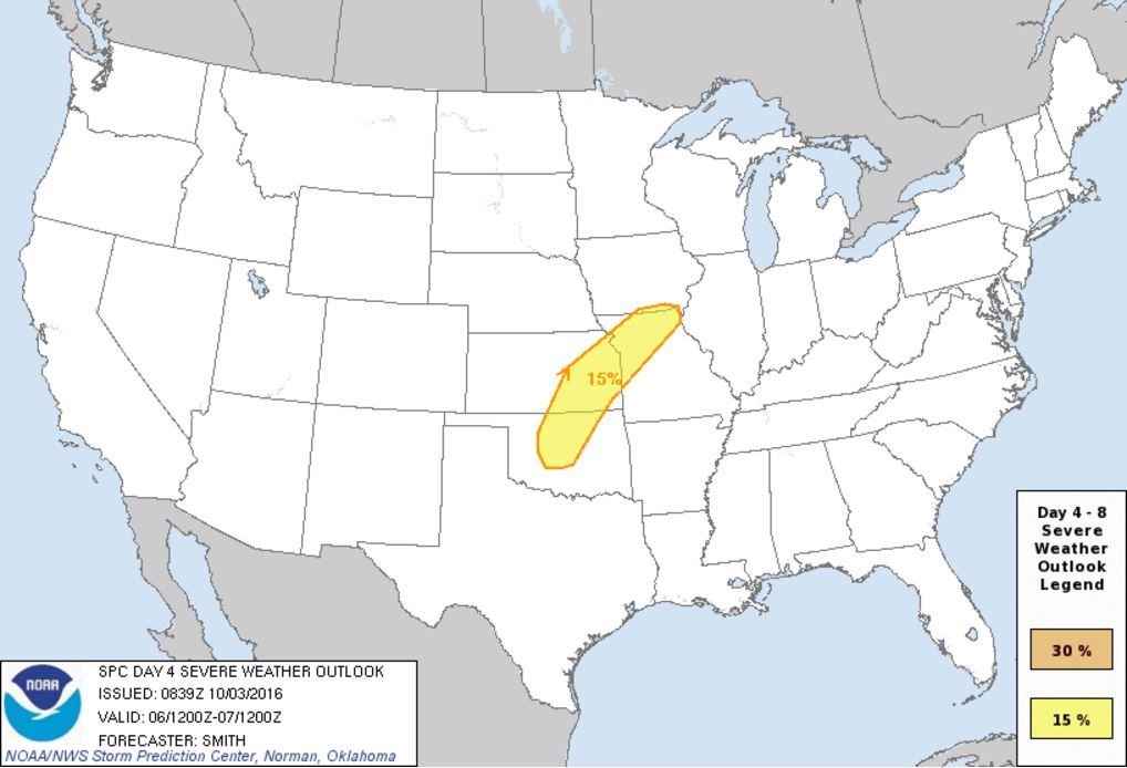
Severe Threat Thursday
...DISCUSSION... THE POTENTIAL FOR ORGANIZED SEVERE THUNDERSTORMS WILL LIKELY FOCUS DURING THURSDAY /DAY 4/ FROM PARTS OF OK NORTHEASTWARD INTO THE LOWER MO VALLEY. DETERMINISTIC AND ENSEMBLE MODEL DATA SUGGEST A SHARP GRADIENT BETWEEN THE WEAK FLOW ASSOCIATED WITH THE SUBTROPICAL/TROPICAL REGIME OVER THE SOUTHEASTERN STATES AND THE WESTERLIES. THE MOST LIKELY OVERLAPPING OF THE MOIST/UNSTABLE CONDITIONS AND STRONGER WIND PROFILES WILL OCCUR ON THE NORTHWESTERN PERIPHERY OF A WARM SECTOR ACROSS THE SOUTHERN-CENTRAL PLAINS INTO THE MID MS VALLEY REGION. FROM FRIDAY /DAY 5/ INTO EARLY THE FOLLOWING WORK WEEK...MODELS INDICATE A LOWER AMPLITUDE FLOW REGIME WILL PREVAIL ACROSS THE CONUS...LENDING LOW POTENTIAL FOR CONCENTRATED AREAS OF ORGANIZED SEVERE THUNDERSTORMS.
Precipitation Outlook
The heaviest rainfall over the next few days will once again develop across the Central U.S. as our next storm system moves in. There will also be heavier precipitation across the Northwest and the High Plains. Also note the heavy precipitation just east of the East Coast, this is associated with "Matthew".
___________________________________________
"While Earth’s Carbon Clock Ticks, Climate Danger Goes Missing From Election Fight"Events are conspiring to make Clinton or Trump the most powerful player in the effort to slow global warming. For a relatively slow-burning phenomenon, climate change is having a moment of great consequence this week. A cascade of events—physical, legal, political, and diplomatic—is underway. While you wouldn’t know it from the cacophony of the presidential campaign, these dramatic changes may allow the winner to dictate what direction the world heads in, for better or worse, when it comes to fighting global warming. First off, this year is expected to smash the global average heat record, set last year, which eclipsed the mark set the year before. Each decade since the 1980s has been hotter than the previous one. (Scientists explain the human contribution like this.) Second only to temperature, climate risk is most commonly represented by a single number: The amount of atmospheric carbon dioxide. Humanity has increased the CO2 level by 43 percent since industrialization in the mid-19th century. This fall, the CO2 level crossed a symbolic threshold for good—400 parts per million. For the uninitiated, take any volume of atmospheric gas, divide it into a million parts, and there will be enough CO2 to make up more than 400 of them. It may not seem like a lot, but it’s the highest level in at least 800,000 years. The period right before industrialization averaged about 280 ppm.
See more from Bloomberg.com HERE
__________________________________________________________________
Thanks for checking in and don't forget to follow me on Twitter @TNelsonWX
No comments:
Post a Comment