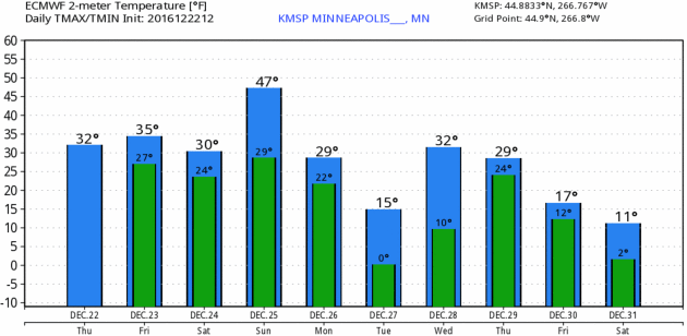
37 F. high temperature in the MSP metro area yesterday.
25 F. average high on December 22.
35 F. high on December 22, 2015.
December 23, 1996: Heavy snow accumulates across much of southern and central Minnesota. Snowfall totals included 6 to 8 inches across the Twin Cities metro area, 10 inches in Jordan, 8 inches at Cambridge, Forest Lake, Hutchinson and Montevideo, and 6 inches at St. Cloud, Glenwood and Redwood Falls.
December 23, 1983: The Twin Cities experience a bitterly cold high of 17 degrees below zero.
December 23, 1833: A 'warm spell' is reported at Ft. Snelling. The temperature reached 45 degrees.

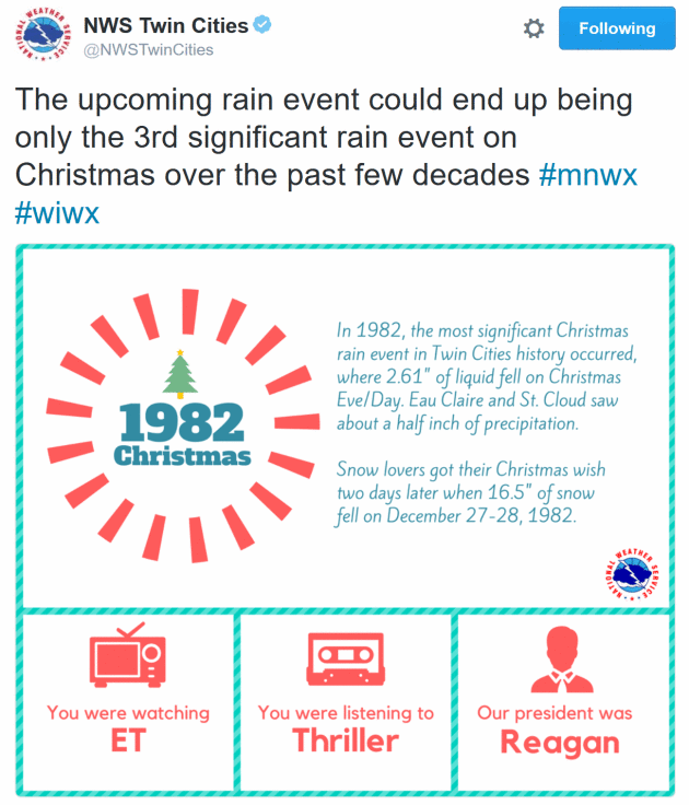
Santa Will Need His "Rain-Deer" on Christmas Day
I've been waiting 6 months to say this: the days are getting longer now. In about 3 weeks average temperatures begin to rise again, for the first time since July. The first cold wave of winter came a few weeks early - so did the January Thaw.
During an average winter about 105 snow-producing storms impact the United States. If a storm tracks to your south a northeast wind insures a supply of cold air, favoring snow. In stark contrast, Sunday's storm will track well west of the Twin Cities, allowing a strong storm to inhale mild air into its circulation, with southeast winds at the surface which usually changes snow over to ice or rain.
Any glaze ice Christmas morning should quickly give way to rain, heavy at times. A few T-storms can't be ruled out. Over 1 inch of rain falling on frozen ground will lead to run-off with potential flash flooding on the roads and ice jams on area rivers.
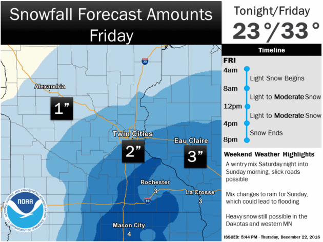
Bottom line: if you want to play in the snow get out there today or Saturday. Today a wrinkle of cold air aloft squeezes out a quick inch of slush. Tomorrow looks like the better travel day, by far.
Sunday will be a mushy, Marchlike mess.
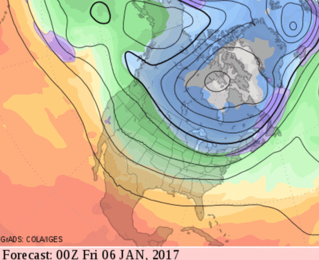
60-Hour Snowfall Potential. A weak disturbance pushes a shield of wet snow across the Upper Mississippi Valley, a quick 1-2" of slushy snow for parts of southern Minnesota and Wisconsin; plowable snows for southwest Colorado and parts of Utah. NAM guidance: NOAA and AerisWeather.

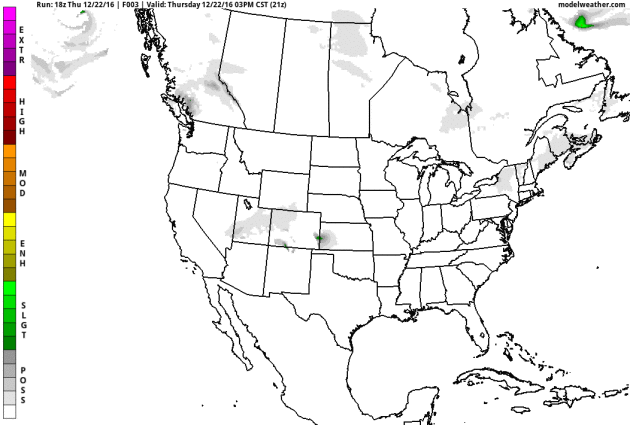
Future Radar. A weak storm over the Four Corners region of the southwest pushes light precipitation into the Midwest today; a mix of rain and snow likely. A stronger storm pushing heavy rain across California will wind up into a much stronger area of low pressure over the High Plains by Sunday, pulling enough warm air into its circulation for rain unusually far north. GFS guidance: Tropicaltidbits.com.
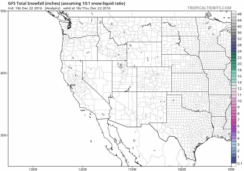
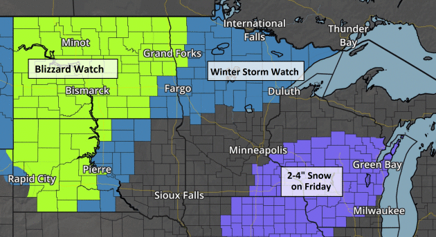
10-Day Snowfall Potential. Heaviest snows between now and Monday fall from the central Rockies into North Dakota and the Red River Valley of far northwestern Minnesota, where well over a foot of new snow may fall.
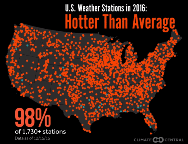
| RELATED | Record-Warm Autumn Solidifies 2nd-Hottest Year for U.S. 2016 Is Days Away from Sealing Record-Hot Spot Record Highs Could Outpace Lows 15-to-1 |
|---|
Those record-hot places can be found from coast to coast. They include medium-sized cities like Asheville, N.C., Modesto, Calif., and Flint, Mich., as well as lesser-known locales like Neosho, Mo., Callahan, Calif., and Climax, Colo. While some of the heat was driven by the super El Niño earlier this year, that alone doesn’t explain all the records being set, particularly in the latter half of the year after El Niño faded. Climate change has caused the U.S. average temperature to increase about 1.5°F since the 1880s..."
Animation credit: "Weather stations in the U.S. that are having a warmer than normal, colder than normal and record hot year."
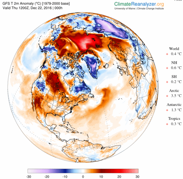
Image credit: Climate Reanalyzer.
Update...
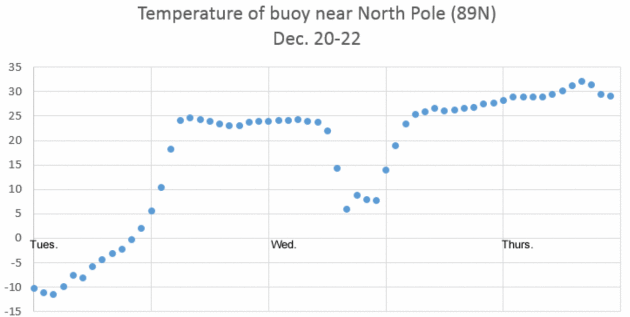
Image credit: "Temperature near 89N latitude Dec. 20-22. (Data from North Pole Environmental Observatory buoy 300234064010010"
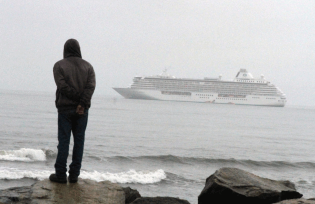
Photo credit: "The cruise ship Crystal Serenity, anchored outside Nome, Alaska, in August, before its inaugural voyage through the Northwest Passage. The trip would not have been possible before climate change led to diminished sea ice coverage." Credit Mark Thiessen/Associated Press.
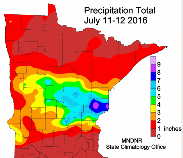
Central Minnesota Flash Flood July 11-12, 2016
The largest flash flood since the Northeast Minnesota event of June 10-20, 2012 struck part of the same region on July 11-12, 2016. The highest two-day total was a volunteer reader in Pine County with 9.34 inches. Southbound I-35 and Highway 61 was closed for a time on July 12. The area covered by six inches or more of rainfall exceeded 2,000 square miles, qualifying it as a "Mega Rain" event. The flooding would have been worse had it not been for the relatively dry conditions beforehand. In addition to the heavy rain, there were three tornadoes, two of which were EF2.
http://www.dnr.state.mn.us/cli
Severe Storms Strike Northland Again: July 20-21, 2016
Just over a week later, another line of intense thunderstorms swept across northern Minnesota. The Hallock Airport in Kittson County had a wind gust of 83 mph. Planes were flipped over at the Bemidji Airport. 75,000 Minnesota Power customers lost power. The storms also moved through the Boundary Waters Canoe Area Wilderness, tragically killing two campers on Basswood Lake in Quetico, just across the Minnesota border in Ontario.
http://www.dnr.state.mn.us/cli
Flooding Rains: August 10-11, 2016
The second "Mega Rain" event of the year happened on August 10-11, 2016. The highest total found was 9.74 inches of rain at a Soil and Water Conservation District volunteer rain gage site in Kandiyohi County. The arena and track at the Kandiohi County Fairgrounds flooded, postponing the demolition derby on the 11th. There were many reports of basement flooding in Willmar.
http://www.dnr.state.mn.us/cli
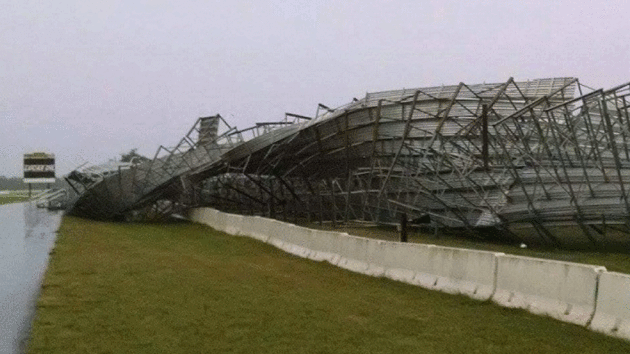
Photo credit: "Grandstand Damage at the Brainerd International Raceway." Courtesy: Chris Wilkoske.
#5 Smoky Skies: July 6, 2015
One of the more bizarre candidates originated from Canada in the form of smoke. There were smoky skies at various times in the summer of 2015, with the thickest smoke observed on July 6, 2015. Visibilities were reduced to a mile and a quarter in St. Cloud and two-and-a-half miles in the Twin Cities. The scent of smoke was in the air and a pall hung over the metro. All courtesy of a cold front bringing smoke from fires in Saskatchewan and northern Manitoba over 1,000 miles away.
#4 Straight Line Winds Wreak Havoc in the Brainerd Lakes Area: July 12, 2015
The most damaging severe storm event of the year came in the form of a line of severe thunderstorms that brought winds from 70 to 95 mph in an area just south of Wadena eastward to the Pillsbury State Forest where winds were in excess of 100mph in places. Significant damage was done to resorts on Gull and North Long Lake as well as the grandstand at the Brainerd International Raceway...."
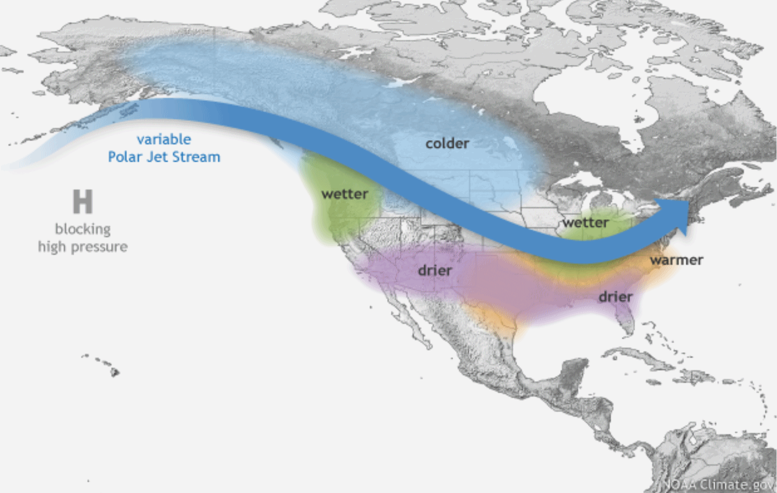
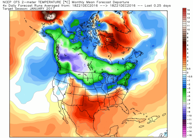
La Nina Signal on Winter Patterns. Just like El Nino warming phases, no two La Nina cooling phases are identical. Buyer beware - generalities and oversimplifications are rampant, and short-sighted. Here's an excerpt of a good explainer at NOAA's Climate.gov: "...I’m sure you’re thinking “this is great and all, but I’m more of a visual learner and I have places to be, could you simply summarize this in a graphic?” Of course! When we combine and condense the important facts with what we already know happens to the jet stream across the Pacific Ocean during La Niña – and we apply an artistic brush – we get what you see above. A retracted jet stream over the Pacific causes a ripple effect on the atmospheric flow across the United States, which means warmer and drier than average temperatures over the southern U.S. while colder temperatures can filter in across the northwestern and north-central U.S. Wetter conditions prevail in the Pacific Northwest and Ohio River Valley as storms follow around the blocking high in the Pacific or across more northern areas near the Great Lakes. And the southern tier of the United States tends to be drier and warmer than normal as storms keep away..."
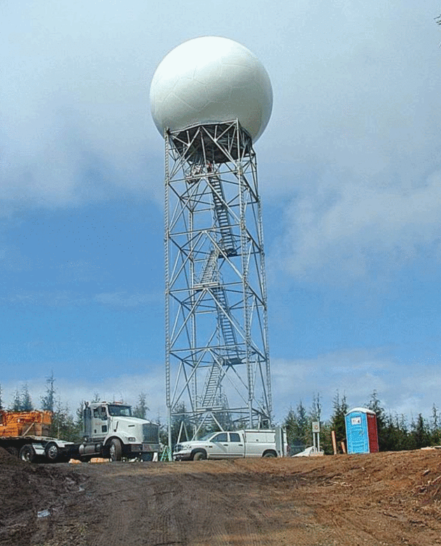
Photo credit: Cliff Mass, University of Washington. "Construction of a Doppler radar station on Langley Hill in Grays Harbor County has meant a major improvement in weather forecasting on the Washington and north Oregon coasts since it went into operation in September 2011. It cost about $9 million. A similar facility is needed for the next stretch of coastline to the south."
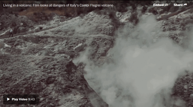
Image credit: "In this educational film, researchers explain the dangers residents face living near the area of the Campi Flegrei volcano, near the Italian city of Naples." (YouTube/UPStrat-MAFA)
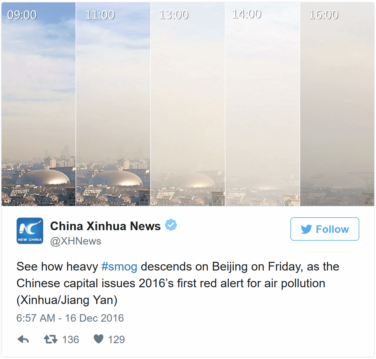
Beijing Now Has "Smog Refugees". Mashable reports that at least 150,000 people have fled thick smog.
How Bad Air Came Back. Here's more perspective from TIME: "...Delhi
ranks high on a World Health Organization (WHO) list of cities with
unhealthy levels of air pollution, but it is far from alone. WHO
research found that 90% of the world’s population lives in areas with
unsafe air-pollution levels. And it’s not just cities in the developing
world, like Beijing, that face dirty air–Western metropolises like New
York City and London are on the list as well. At the beginning of
December, Paris was hit by some of the worst air pollution in a decade,
leaving the Eiffel Tower cloaked in smog. For all the deserved focus on
climate change as the planet’s major environmental threat, a much older
one–bad air–is still a persistent danger. Economic growth in places like
Delhi and Beijing has led to the rapid construction of coal-fired power
plants, quick factory construction and traffic-choked streets.
Regulations–to the extent that they exist in these places–receive little
attention from the officials charged with enforcing them..."
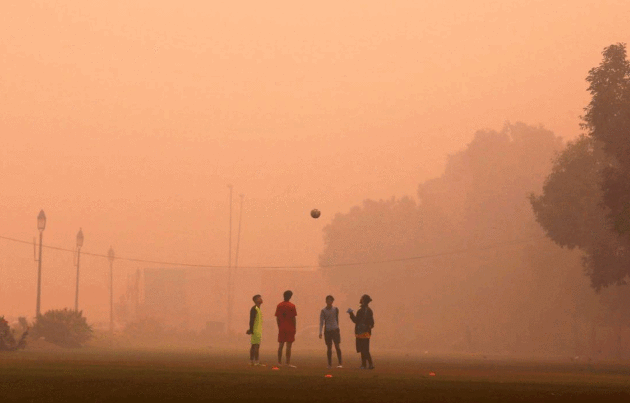
Photo credit: Adnan Abidi—Reuters. "Children play on a smoggy day in New Delhi, where thousands die early from air pollution yearly."
GPG Survey of Trump Voters. I was pleasantly surprised by the desire to keep clean energy policies in place. Here's an excerpt from GPG.com: " This week, GPG and Morning Consult released the results of a poll of self-identified Trump voters, the first post-election poll conducted to probe specific policy views (full press release below). Below we have pulled out topline findings related to energy, climate, environment and infrastructure. In general, Trump voters are supportive of protecting both the climate and the environment, and strongly endorse spending on renewable energy and infrastructure.
TOP ENERGY/ENVIRONMENT FINDINGS
· Trump voters support plans to combat climate change and cut carbon emissions:
o More
than half (55%) of Trump voters support upholding policies currently in
place to combat climate change, with 30% saying we should implement new
policies that go even further.
o 61% of Trump voters think the government should require US companies to reduce carbon emissions
· Trump voters support spending on renewable energy, environmental protection and preservation:
o Nearly three-quarters (73%) of Trump voters think that we should maintain or increase spending on renewable energy.
o 64% of Trump voters think the budget for environmental protection and preservation should be maintained or increase..."
As Republicans take Minnesota's Legislature, Clean Energy Still On The Table. Here's an excerpt from Midwest Energy News: "While
Republicans will control both houses of Minnesota’s legislature next
year, a recent forum suggests clean energy policy – particularly for
solar and electric vehicles – will still have a place in the
conversation. Speaking at the legislative preview last week on energy,
transportation and climate change mitigation sponsored by the Environmental Initiative,
Rep. Pat Garofalo, chair of the House Job Growth and Energy
Affordability Policy and Finance Committee, praised the state’s
community solar program for being a cheaper alternative than rooftop
solar and suggested the program should win bipartisan support..." (File photo: Orlin Wagner, AP).
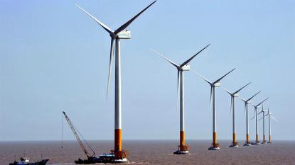
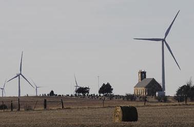
Why Is Corporate America Picking Wind Power Over Solar? The Guardian reports: "...Wind
energy has historically been much cheaper than solar, making it a more
attractive option, especially when energy can be a major expense for a
company. As more businesses come under pressure from their customers,
investors or government regulators to cut their greenhouse gas emissions
and help rein in global warming, they will be looking for low-carbon
energy that can compete with the price of coal and natural gas. Wind and
solar are not the only sources of electricity with lower carbon
footprints than coal and natural gas. Hydropower and nuclear are too,
and, unlike solar and wind, are able to produce electricity any time.
But hydropower plants require access to ample sources of surface water. A
nuclear power plant can take longer to secure permits and cost more than building other types of power plants..."
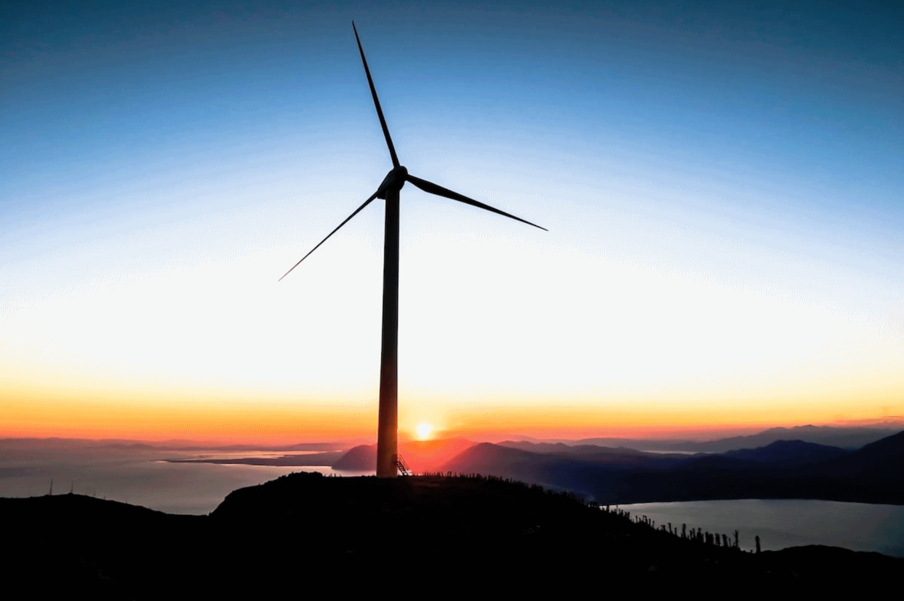
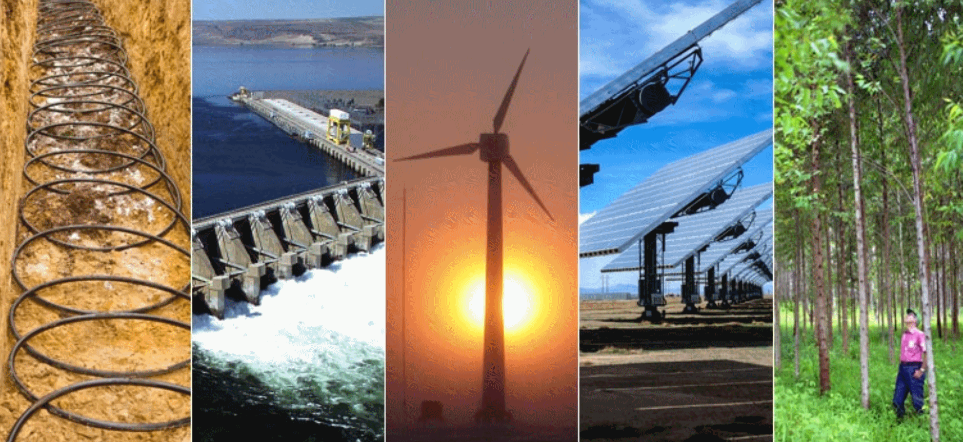
Businesses and States Are United on Clean Energy. Forbes has an Op-Ed that resonated: "...You
may not know it from the headlines, but Washington is not the only
energy game that matters these days. Companies that buy massive amounts
of energy and states that set the policies that shape the energy mix of
their economies – whether with clean energy or climate-warming fossil
fuels – also play a major role. Corporate and state efforts are driving
the country’s extraordinary progress in growing the economy while
reducing carbon pollution. Since 2000, according to the Brookings Institute,
the U.S. GDP has grown by 30 percent while carbon pollution has fallen
10 percent. And, judging from business and state actions in recent
weeks, interest in using more renewable energy and energy efficiency is
getting stronger and shows no sign of abating..." (Image credit: Climate Reality).
To Slow Global Warming We Need Nuclear Power. Here's an excerpt of an Op-Ed from Senator Lamar Alexander and Senator Sheldon Whitehouse at The New York Times: "...In roughly two decades, the United States could lose about half its reactors. That’s because, by 2038, 50 reactors will be at least 60 years old, and will face having to close, representing nearly half of the nuclear generating capacity in the United States. Without them, or enough new reactors to replace them, it will be much harder to reduce carbon emissions that contribute to climate change. Unfortunately, some of our federal policies to encourage clean energy, such as the Clean Energy Incentive Program within President Obama’s Clean Power Plan, do not explicitly include or incentivize nuclear power. Likewise, some states have chosen to adopt policies, such as renewable portfolio standards, that do not include or incentivize nuclear power..."
File photo credit: Nuclear Regulatory Commission.

Illustration credit: "Skiing Through History, December 2013."
TODAY: Wet snow, coating - 2" slush. Mainly wet roads. Winds: S 10-15. High: 34
FRIDAY NIGHT: Flurries taper, slick spots on the highways. Low: 23
CHRISTMAS EVE: Mostly cloudy, good travel weather. Winds: SE 5-10. High: 32
CHRISTMAS DAY: Soggy Santa. Ice changes to heavy rain. Few T-storms, risk of flash flooding by evening. Winds: SE 15-25. Wake-up: 29. High: 45
MONDAY: Gusty and colder with flurries. Winds: NW 20-35. Wake-up: 29. High: 31 (falling)
TUESDAY: Partly sunny and cool. Winds: SW 7-12. Wake-up: 17. High: near 30
WEDNESDAY: Mostly cloudy, few flurries around. Winds: S 8-13. Wake-up: 20. High: 33
THURSDAY: Cold wind, coating of flurries? Winds: NW 15-25. Wake-up: 18. High: 29
Climate Stories...
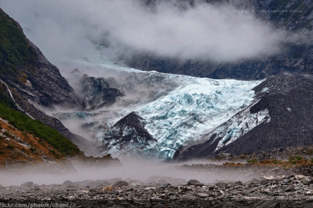
Photo credit: "Franz Josef Glacier in New Zealand, one of the glaciers whose retreat is almost certainly linked to global warming." Credit: Christopher Chan/flickr
Beliefs About Climate Change May Reflect a Failure to Understand What Climate Change Is. Here's a snippet from Forbes: "...The researchers found that over the 50 year period, temperatures that favored local warming at a rate higher than would be expected to occur by chance were recorded at 49% of the weather stations included in the study. An additional 10% of the weather stations recorded temperatures that favored local cooling. Changes in local weather were reliably correlated with people’s belief about climate change. People who live in areas that have experienced more record high temperatures than lows are likely to believe climate change is happening. Conversely, people who live in areas that have experienced more record lows than highs are likely to believe climate change is not real..."
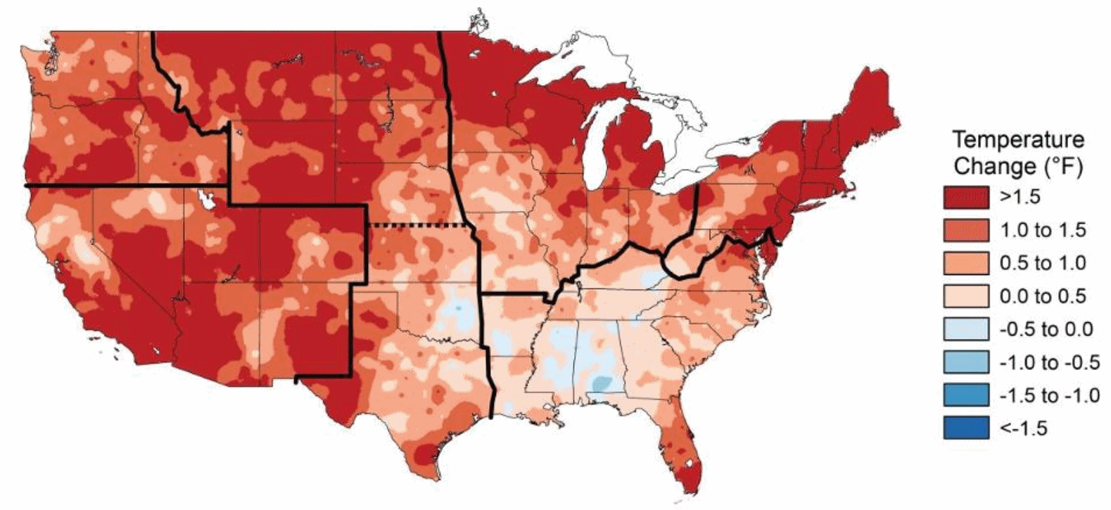
Map credit: "Temperature change in the US compared to average temperatures from 1901 to 1960." Credit NASA

Earth's Temperature to Dip, But Still Sizzle in 2017. Reuters has the latest: "World temperatures are likely to dip next year from a sizzling record high in 2016, when man-made global warming was slightly boosted by a natural El Nino event in the Pacific Ocean, scientists said on Tuesday. It is still likely to be the third warmest since records began. The year-on-year decline will coincide with the first year of Donald Trump's presidency. He has sometimes dismissed as a hoax the idea that global warming is caused by human activity. "Next year is not likely to be a record but it will still be a very warm year," Professor Adam Scaife of the British Met Office told Reuters of a report on Tuesday based on new computer data. He said it would be wrong for anyone who doubts that climate change is caused by humans to interpret the expected 2017 dip, prompted by the end of El Nino, which released heat from the Pacific Ocean, as a sign of an end to the long-term trend of global warming..."
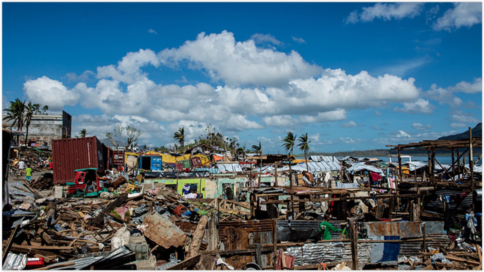
El Nino-Linked Hurricanes to Increase in Pacific With Global Warming. Data suggests that warmer water, throughout a deeper layer of the western Pacific, is increasing wind speeds and intensities. Here's an excerpt from Reuters: "Small Pacific island states could be hit by more tropical cyclones during future El Nino weather patterns due to climate change, scientists said on Tuesday. El Nino is a warming of sea-surface temperatures in the Pacific occurring every two to seven years which can trigger both floods and drought in different parts of the world. Its opposite phase, a cooling of the same waters known as La Nina, is associated with the increased probability of wetter conditions over much of Australia and increased numbers of tropical cyclones. Between 2070 and the end of the century, Fiji, Vanuatu, Solomon Islands, Marshall Islands and Hawaii could face an increased frequency in powerful storms during El Nino of up to 40 percent, Australian meteorologists said in a study..." (Typhoon Haiyan image: Asian Development Bank).
Voice of America has more perspective on the apparent increase in Pacific typhoon intensity here.
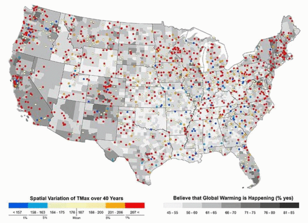
Map credit: "Local weather may impact whether or not Americans believe in climate change." Michelle Gilmore.
Scientific American has more context on how our views and opinions on climate are shaped by weather. My take: it's a little like confusing an argument (weather) with a 40-year marriage (climate).
No comments:
Post a Comment