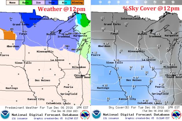
First Cold Blast of the Season
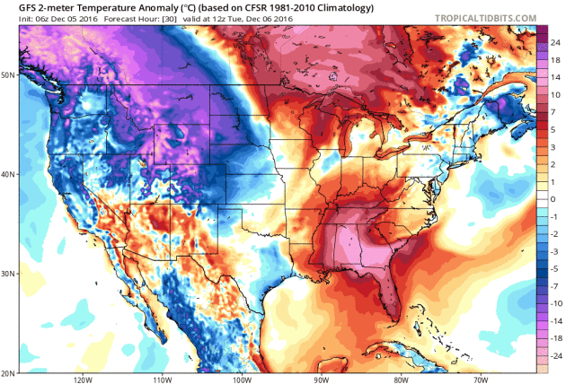
The first cold blast of the season to impact much of the nation is on its way into the Lower 48 now. Take a look at the temperature anomaly loop below, which shows much cooler than average temperature pushing through the central and eastern US through the end of the week.
 84-Hour Outlook
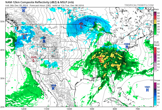
The national weather outlook through Thursday shows 2 different systems moving through the eastern half of the country through midweek. The system in the Upper Midwest will be responsible for heavy snow and blizzard-like conditions. The southern system will continue to lift northeast with spotty strong to severe storms and locally heavy rain across parts of the Southeast and Mid-Atlantic States. Meanwhile, another surge of heavier moisture will push into the West Coast later this week with heavy rain along the coast and heavy snow in the high elevations
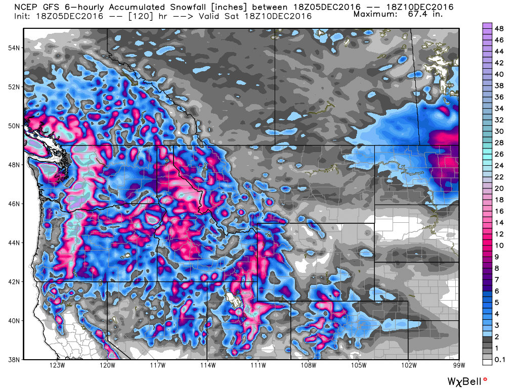
 10-Day Snowfall Outlook
It appears that winter weather has finally moved in across parts of the country. With colder than average temperatures across much of the nation this week and perhaps even into the middle part of the month, wintry precipitation will likely follow. Here's the 10-day snowfall potential, which shows heavy pockets of snow across the northern half of the nation.
________________________________________________________
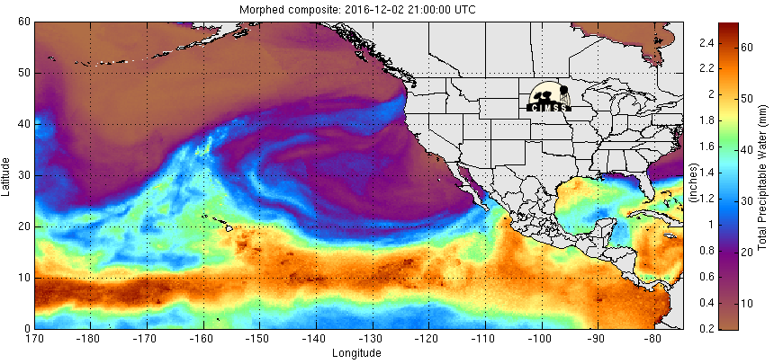
Pacific Moisture Moves into the Pacific Northwest
Here's the Eastern Pacific precipitable water loop that shows heavier moisture from the Pacific moving into the West Coast in a few different waves. The next big round is building north of Hawaii and will be heading into the Western US later this week with heavy rain along the coast and heavy snow in the high elevations.
Another Surge of Heavier Pacific Moisture Late Week
Here's a look at the next storm system moving into the Western US later this week. Note the continued surge of moisture over a several day time period. This should allow several inches of precipitation to add up, which will be in the form of heavy rain along the coast and heavy snow in the high elevation.
 Snow in the Northwest
Here's the snowfall potential through Saturday, which shows fairly significant tallies across the Cascade range and across much of the central and northern Rockies. Some spots could see up to 1ft. to 2ft. by the weekend. Some locations in the Sierra Nevada Range will even see some snow!
 __________________________________________________________________________________
 Heavy Southern Rain
 Somewhat Active Pattern With Colder Temps Ahead.
The first cold blast of the season to impact much of the nation is on its way into the Lower 48 now. Take a look at the temperature anomaly loop below, which shows much cooler than average temperature pushing through the central and eastern US through the end of the week.
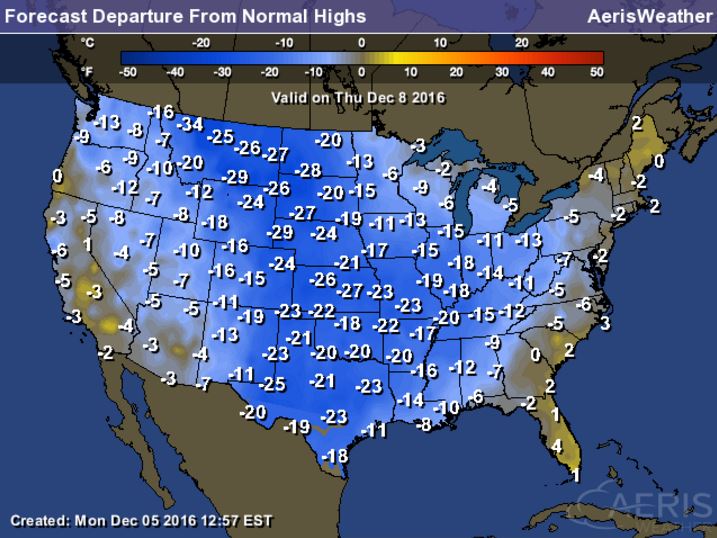
High Temperatures From Average on Thursday
Here's a look at high temperatures from average across the nation on Thursday and note that many locations will be nearly 15F to 25F colder than average! Some spots along the Front Range of the Rockies could be nearly 30F below average then... BRR!
The national weather outlook through Thursday shows 2 different systems moving through the eastern half of the country through midweek. The system in the Upper Midwest will be responsible for heavy snow and blizzard-like conditions. The southern system will continue to lift northeast with spotty strong to severe storms and locally heavy rain across parts of the Southeast and Mid-Atlantic States. Meanwhile, another surge of heavier moisture will push into the West Coast later this week with heavy rain along the coast and heavy snow in the high elevations
It appears that winter weather has finally moved in across parts of the country. With colder than average temperatures across much of the nation this week and perhaps even into the middle part of the month, wintry precipitation will likely follow. Here's the 10-day snowfall potential, which shows heavy pockets of snow across the northern half of the nation.
________________________________________________________
Pacific Moisture Moves into the Pacific Northwest
Here's the Eastern Pacific precipitable water loop that shows heavier moisture from the Pacific moving into the West Coast in a few different waves. The next big round is building north of Hawaii and will be heading into the Western US later this week with heavy rain along the coast and heavy snow in the high elevations.
Another Surge of Heavier Pacific Moisture Late Week
Here's a look at the next storm system moving into the Western US later this week. Note the continued surge of moisture over a several day time period. This should allow several inches of precipitation to add up, which will be in the form of heavy rain along the coast and heavy snow in the high elevation.
Here's the snowfall potential through Saturday, which shows fairly significant tallies across the Cascade range and across much of the central and northern Rockies. Some spots could see up to 1ft. to 2ft. by the weekend. Some locations in the Sierra Nevada Range will even see some snow!
__________________________________________________________________________________
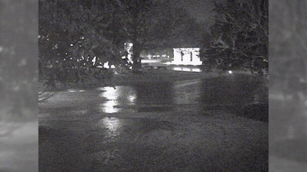
Heavy Rain in the South Past Few Days
Take a look at the webcam look from Alexandria, LA from AM Monday. Note the standing water! Many locations in these areas have seen 3" to 6"+ rainfall since the weekend!
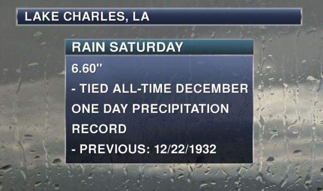
Record Rainfall!
How about this record out of Lake Charles, LA that saw 6.60" of rain on Saturday, which tied the all-time wettest December on record also set on December 22nd, 1932.
More Heavy Rain in the South/Southeast
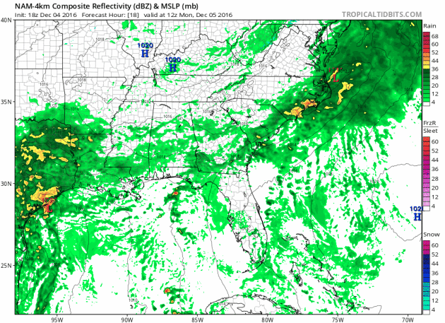
Take a look at the heavy potential across the southern and southeastern US through the middle part of the week! Widespread heavy rainfall could lead to areas of flooding over the next few days, especially over eastern Texas and the Lower Mississippi Valley. Not only will heavy rain be possible, but a few strong to severe storms may be possible into early next week as well.
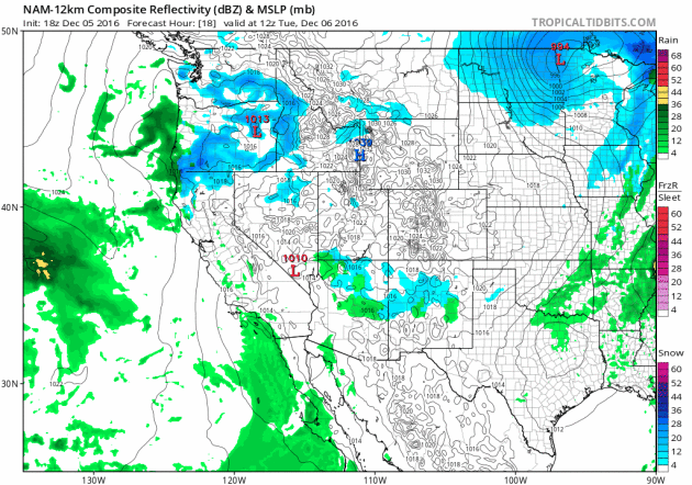
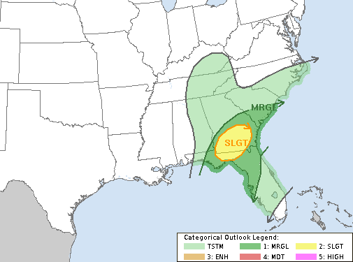
Severe Threat Tuesday
...SUMMARY... AT LEAST A MARGINAL RISK FOR A FEW STRONG TO SEVERE STORMS WITH DAMAGING WIND AND POSSIBLY A TORNADO OR TWO WILL EXIST TUESDAY FROM NORTHERN FLORIDA THROUGH SOUTHERN GEORGIA AND SOUTHERN SOUTH CAROLINA. ...NORTHERN FLORIDA...SOUTH GEORGIA AND SOUTHERN SOUTH CAROLINA... DEAMPLIFYING SHORTWAVE TROUGH OVER THE SOUTHERN APPALACHIANS EARLY TUESDAY WILL CONTINUE THROUGH THE MIDDLE ATLANTIC DURING THE DAY. OCCLUDED LEE CYCLONE OVER THE OH VALLEY WILL WEAKEN...WHILE SECONDARY CYCLOGENESIS COMMENCES OFF THE NORTH CAROLINA COAST IN RESPONSE TO THE DEAMPLIFYING WAVE. A WEAKLY UNSTABLE WARM SECTOR WILL HAVE MOVED INLAND THROUGH SOUTH GEORGIA AND SOUTHERN SOUTH CAROLINA TO THE SOUTH OF A WARM FRONT. THUNDERSTORMS WILL BE IN PROGRESS EARLY TUESDAY ALONG PRE-FRONTAL WARM CONVEYOR BELT FROM THE FLORIDA PANHANDLE THROUGH A PORTION OF EASTERN ALABAMA INTO WESTERN GEORGIA. MOIST INFLOW TO THE UPDRAFTS WILL BE ROOTED NEAR THE SURFACE WITH UPPER 60S TO AROUND 70 F DEWPOINTS...AND STORMS WILL BE EMBEDDED WITHIN STRONG 0-6 KM SHEAR WITH INITIALLY LARGE 0-1 KM HODOGRAPHS PROMOTING A RISK FOR ORGANIZED STORM STRUCTURES. ACTIVITY WILL MOVE THROUGH THE REMAINDER OF NORTHERN FLORIDA...SOUTHERN GEORGIA...AND SOUTHERN SOUTH CAROLINA WITH AN ATTENDANT THREAT FOR A FEW DAMAGING WIND GUSTS AND A COUPLE OF TORNADOES. IT STILL APPEARS THAT WEAK LAPSE RATES...WIDESPREAD CLOUDS AND ONGOING AREAS OF RAIN WILL LIKELY RESULT IN WEAK INSTABILITY WHICH MAY SERVE AS AN OVERALL LIMITING FACTOR FOR A MORE ROBUST SEVERE EVENT. AS INITIAL OCCLUDED LOW MOVES THROUGH THE TENNESSEE VALLEY AND NEW CYCLOGENESIS COMMENCES OFF THE CAROLINA COASTS...TENDENCY WILL BE FOR THE LOW-LEVEL WINDS TO VEER TO SOUTHWESTERLY THROUGH MID MORNING WITH A GRADUAL DECREASE IN HODOGRAPH SIZE. THEREFORE...GREATEST SEVERE THREAT WILL LIKELY REMAIN CONFINED TO A RELATIVELY SMALL WINDOW BETWEEN 12-18Z.
Here's a look at the heavy rain potential through midday Wednesday. Note that some spots across eastern Texas and the Lower Mississippi Valley through the Mid-Atlantic States could see an additional 2" to 4" or more.
__________________________________________________________________
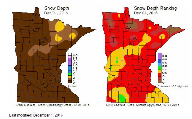
MN Snow Depth & Ranking
Here's a look at the snow depth across the state as of Thursday, December 1st. Note that much of the heavy snow that fell across western and northern MN a couple of weeks ago has since melted due to the ongoing mild weather through the end of November.
Each Thursday during the cold season, the State Climatology Office produces maps depicting the snow depth across Minnesota. Additionally, maps are created that depict snow depth ranking for the date. The data are provided by volunteers working with DNR Forestry, the National Weather Service, the University of Minnesota, Soil and Water Conservation Districts and CoCoRaHS.
Winter Weather Headlines
Snowfall Potential Through PM Wednesday
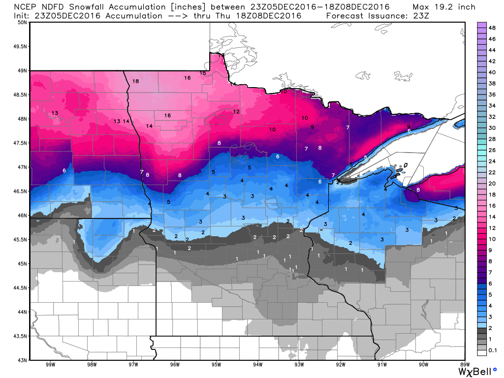
Here's the snowfall potential through midday Thursday, which shows some fairly hefty tallies across the northern part of the state. Note that there will be a fairly large swath of 6" to 12"+ from eastern North Dakota to northwestern Minnesota.
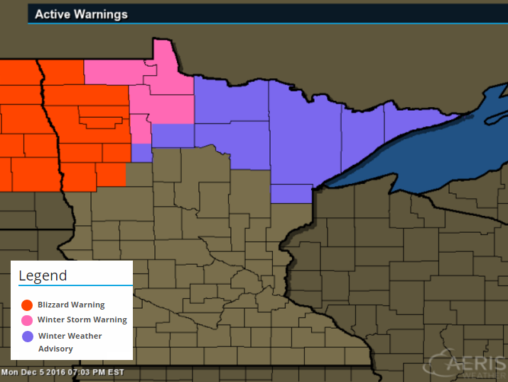
...WINTER STORM WARNING NOW IN EFFECT FROM 6 PM THIS EVENING TO
NOON CST TUESDAY...
...BLIZZARD WARNING IN EFFECT FROM NOON TO 6 PM CST TUESDAY...

THE NATIONAL WEATHER SERVICE IN GRAND FORKS HAS ISSUED A BLIZZARD
WARNING...WHICH IS IN EFFECT FROM NOON TO 6 PM CST TUESDAY.

* TIMING...EXPECT SNOW TO DEVELOP AROUND 6 PM AND THEN DIMINISH
  AROUND 6 PM TUESDAY. BLIZZARD CONDITIONS WILL DEVELOP ON TUESDAY
  AFTERNOON.

* PRECIPITATION RATES...THE HEAVIEST SNOWFALL RATES WILL OCCUR
  BETWEEN 6 PM THIS EVENING AND 6AM TUESDAY.

* SNOW ACCUMULATIONS...10 TO 14 INCHES.

* WINDS...WINDS WILL INCREASE TUESDAY AFTERNOON. NORTHWEST 30 TO
  40 MPH WITH GUSTS UP TO 50 MPH.

* VISIBILITIES...BELOW A HALF MILE IN SNOW TONIGHT...BELOW A
  QUARTER MILE IN SNOW AND BLOWING SNOW ON TUESDAY.
Snowfall Potential Through PM Wednesday
Here's the snowfall potential through midday Thursday, which shows some fairly hefty tallies across the northern part of the state. Note that there will be a fairly large swath of 6" to 12"+ from eastern North Dakota to northwestern Minnesota.
_____________________________________________________________________________
Here's the weather outlook through Sunday. Note the ongoing snow potential across northern MN through the midweek time frame with another chance of snow by the weekend. The big story will be the MUCH colder weather funneling into the region by the 2nd half of the week. This will be some of the coldest air of the season with highs dipping to well below normal temps for a several day period.
.gif)
5 Day Precipitation Outlook
The 5 day precipitation outlook through the weekend suggests heavier moisture along the international border, which will be in the form of heavier snowfall. After that, the next chance of snow will move in this weekend. Stay tuned.
______________________________________________________________________________
News flash! It's going to get colder... finally. Are you surprised? Honestly, I wasn't sure if it would ever happen at the rate we were going. Good grief. It was only a little more than 2 weeks ago that we had our first frost (officially) in the Twin Cities, ending the longest growing season on record of 220 days. We recently just had our 2nd warmest Nov. and the warmest Oct. through Nov. on record.
Get this, Fairbanks, Alaska dipped to -35 degrees on Sunday for the first time in 2 winters! Incredibly, they average a -35 degree or colder temperature 12 times PER YEAR! Also, the mercury in Anchorage, AK finally dipped to 0 degrees ending the 2nd longest streak between 0 degree readings there. Did you hear that the Arctic sea ice was at its 2nd lowest extent on record? Something strange is happening to our climate.
6 to 12+ inches of snow pile up in NW Minnesota Tuesday while single digit wind chills numb faces statewide Wednesday through Friday. I am happy to report that days start getting longer in about 2 weeks! Hello Winter!
___________________________________________________
Extended Weather Outlook
MONDAY NIGHT: Mostly cloudy, Chance of light rain/snow. Winds: SSW 10-15. Low: 27.
TUESDAY: Brisk wind, flakes north. Winds: W 15-25. High: 28.
TUESDAY NIGHT: Mostly cloudy, breezy and colder. Winds: W 15-25. Low: 15.
WEDNESDAY: Colder with single digit wind chills. Winds: W 10-20. High: 21
THURSDAY: Colder. Scattered light snow showers. Winds: NW 10-15. Wake-up: 12. High: 19.
FRIDAY: Less wind. More sun, still chilly. Winds: SSW 5-10. Wake-up: 11. High: 18.
SATURDAY: Increasing clouds, chance of snow. Winds: SE 5-10. Wake-up: 12. High: 24.
SUNDAY: Lingering light snow early. Winds: NW 5-10. Wake-up: 19. High: 26.
MONDAY: A little warmer, few flakes. Winds: S 5-10. Wake-up: 13. High: 28.
_______________________________
_______________________________
This Day in Weather History
December 6th:
1950: A snowstorm hits Duluth with 23.2 inches of snow in 24 hours, and a storm total of 35.2 inches.December 6th:
1939: Warm weather occurs over parts of Minnesota. The high temperature hits 62 at New London.
________________________________
Average High/Low for Minneapolis
December 6th
Average High: 30F (Record: 63F set in 1939)
Average Low: 16F (Record: -19F set in 1972)
Average Low: 16F (Record: -19F set in 1972)
Record Snowfall: 4.4" set in 1969
_________________________________
_________________________________
Sunrise/Sunset Times for Minneapolis
December 6th
December 6th
Sunrise: 7:36am
Sunset: 4:32pm
Sunset: 4:32pm
*Daylight Lost Since Yesterday: ~1mins & 10sec
*Daylight Lost Since Summer Solstice: ~6hours and 39mins
______________________________________________________________________
*Daylight Lost Since Summer Solstice: ~6hours and 39mins
______________________________________________________________________
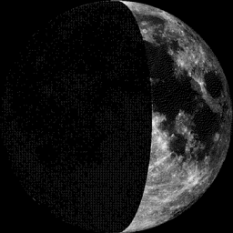
Moon Phase for December 5th at Midnight
1.1 Days Before First Quarter
1.1 Days Before First Quarter
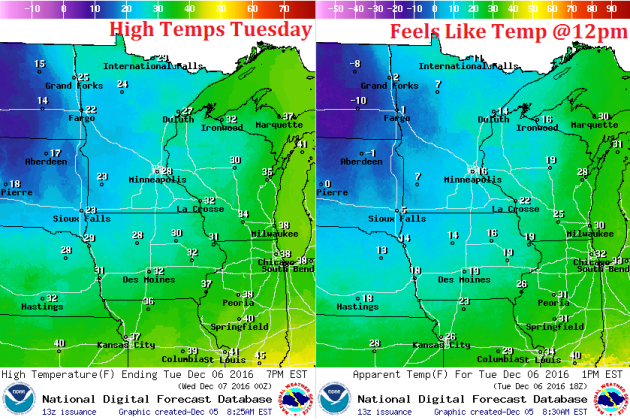
Weather Outlook Tuesday
High temps on Tuesday will be quite a big colder than what we've been dealing with. In fact, feels like temperatures will drop into the single digits and teens across much of the state. Note the sub-zero wind chill values across the Dakotas! Dress appropriately!
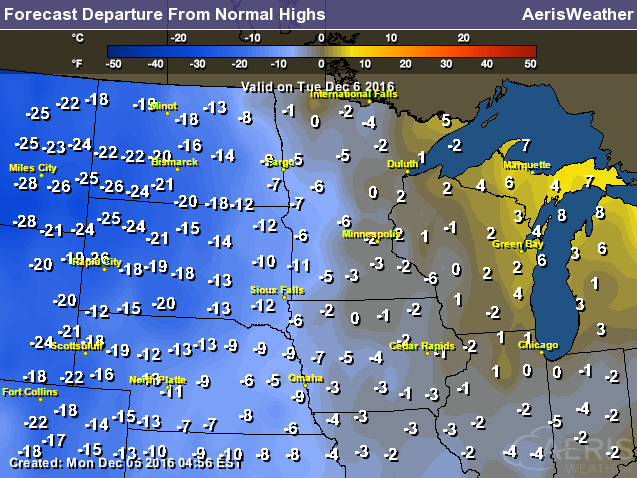
High Temperatures From Average Tuesday
Here's a look at high temperatures from average on Tuesday, which shows colder air starting to surge into the region. Note that many locations across the Dakotas will be nearly 10F to 25F below average.
Weather Outlook Tuesday
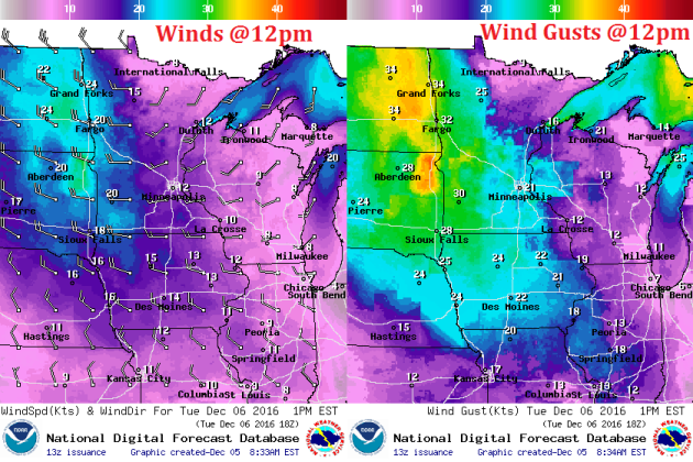
Winds will be very strong across the state on Tuesday with sustained winds of 10mph to 20mph. Wind gusts could be 30mph to 35mph across western MN and the Dakotas, which will help to keep blizzard-like conditions in place across much of North Dakota and northwestern MN during the day Tuesday.
Weather Outlook Tuesday
Heavy snow will begin to taper across northwestern MN with lingering light snow and flurries across the rest of the northern half of the state. This wrap around light snow and flurry activity could sink a little farther south Wednesday & Thursday.
___________________________________________________________
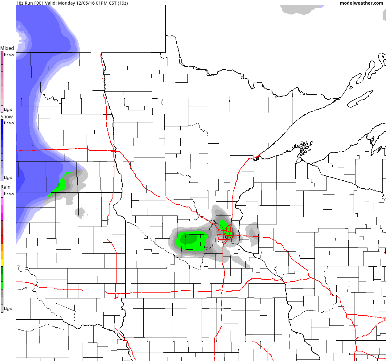
Simulated Radar
The simulated radar from PM Monday to Thursday shows the current storm system swirling through the region, which will continue to bring heavy snow to parts of northern Minnesota through Tuesday. Snow will begin tapering on Tuesday with lingering flurries in place Wednesday and Thursday.
_______________________________________
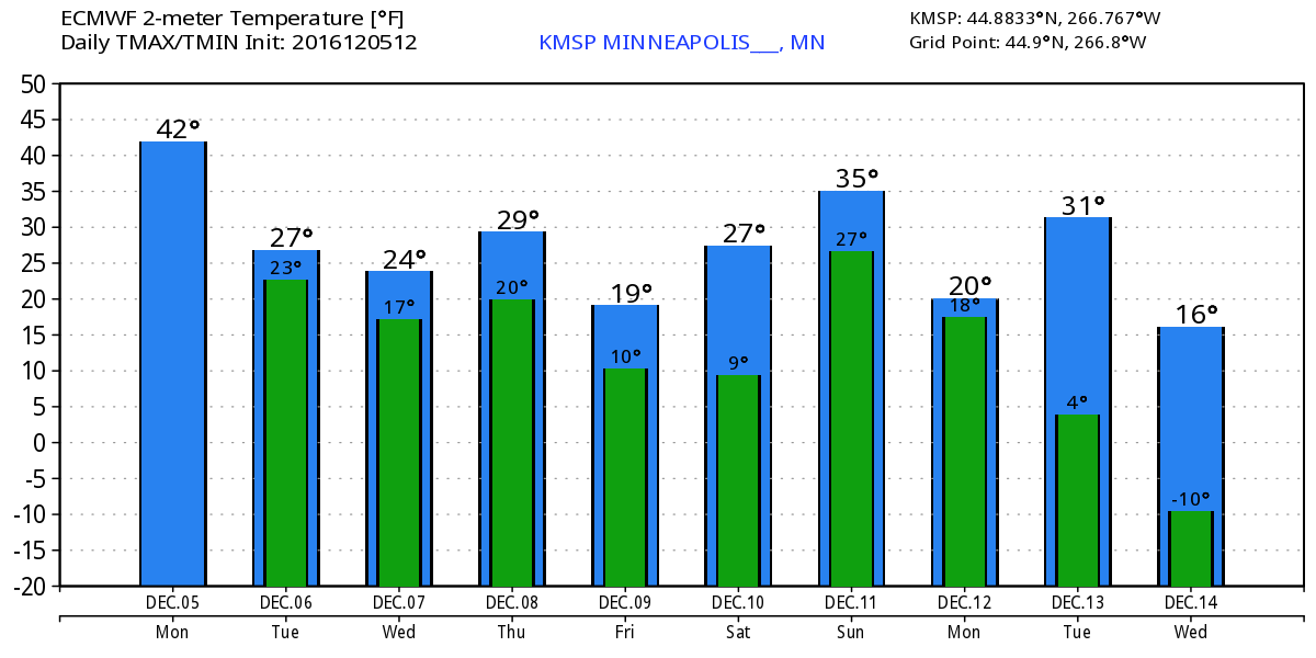
Extended Weather Outlook
The temperature outlook for Minneapolis shows MUCH cooler temps on the way for the rest of the week and through the middle part of the month. Highs will dip into the 10s and 20s with overnight lows in the single digits and 10s across much of the state.
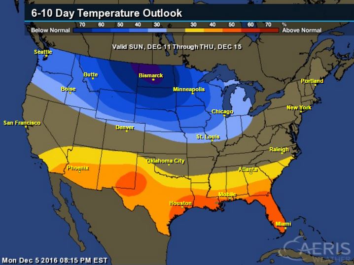
6 to 10 Day Temperature Outlook
According to NOAA's CPC, the 6 to 10 day temperature outlook suggests colder than average temperatures settling into the region as we continue through the first half of December. Note that this will likely be some of the coldest air of the season for many spots across the Upper Midwest.
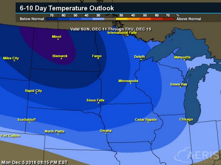
Here's the national temperature outlook from December 11th - December 15th, which shows colder than average temperatures continuing across the northern tier of the nation. Folks across the southern tier of the nation will start to see temps warm back to above average levels as the strong upper level winds begin to lift a little farther north.
 __________________________________________
National Weather Outlook
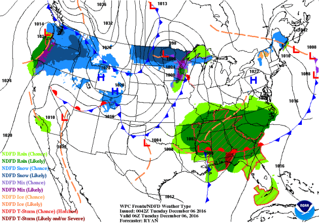
The storm system responsible for locally heavy rain and spotty severe storms across the southern US will begin lifting north toward the Mid-Atlantic by the middle part of the week A few strong to severe storms may still be possible in the Southeast on Tuesday, but the severe threat ends Wednesday. Meanwhile, heavy snowfall in the Upper Midwest from earlier this week will begin to taper through Wednesday. Another surge of Pacific moisture will move into the Western US later this week with heavy rain along the coast and heavy snow in the higher elevations.
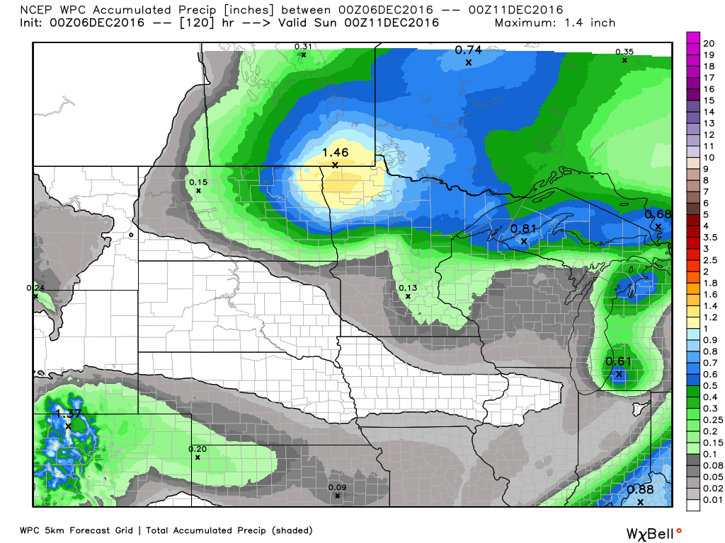
5 Day Precipitation Outlook
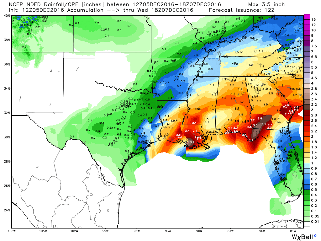
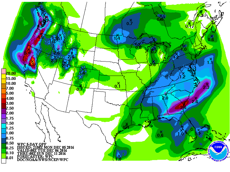
According to NOAA's WPC, the 5 day precipitation outlook suggests that the heaviest rainfall that fell in the Southern US earlier this week will begin shifting east with some 1" to 2"+ amounts still possible from northern Florida to the Outer Banks of North Carolina. Note the heavy moisture moving into the Western US with some 3" to near 6"+ liquid possible through Saturday.
US Drought Monitor
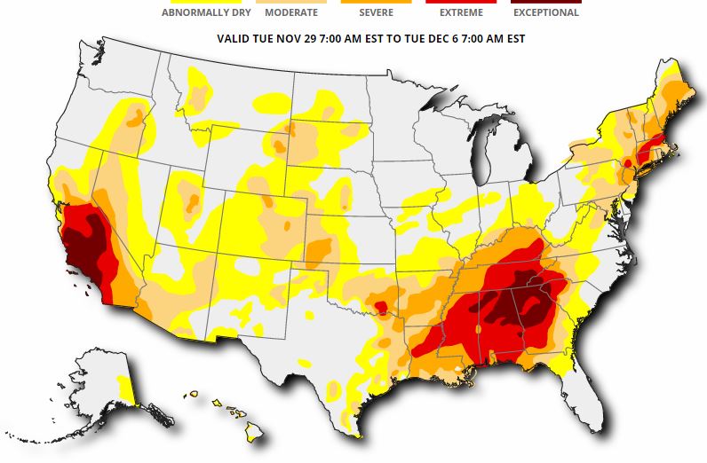
Here's the updated drought monitor from Thursday, December 1st, which shows widespread extreme to exceptional drought conditions across much of the Southeast. We'll see if drought conditions improve later this week after this more recent round of heavier precipitation.
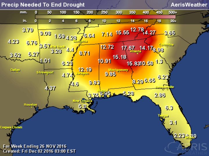
Rainfall Needed to End Drought
The product below suggests how much rainfall is needed to end the drought. Note that many spots need nearly a foot of rain or more to end the drought. These are the areas that are in an extreme to exceptional drought!
____________________________________________________________________________
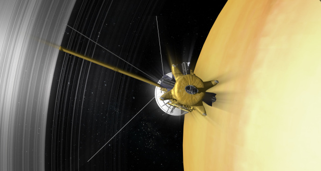
Cassini: The Mission to Saturn and the Grand FinaleDo you remember Cassini? Cassini was a satellite launched by NASA nearly 20 years ago in an attempt to study Saturn better. In less then 1 year, Cassini will be ending its mission by plunging into Saturn's orbit. Until then, it will still be exploring. Here's an excerpt from NASA below:
See the full story from NASA HERE:
After almost 20 years in space, the Cassini mission will end on September 15, 2017 at 5:07 a.m. PDT (8:07 a.m. EDT). Here's how it will happen:
In late 2016, the Cassini spacecraft will begin a completely new type of mission at Saturn. During its final months, the intrepid spacecraft's orbit will carry it high above the planet's north pole and then send it plunging between the planet and the innermost edge of its dazzling rings.
Beginning on Nov. 30, 2016, Cassini will repeatedly climb high above Saturn's north pole, then plunge to a point just outside the narrow F ring (the edge of the main rings), completing 20 such orbits. Then, on April 22, 2017, Cassini will leap over the rings to begin its final series of daring dives between the planet and the inner edge of the rings. This is the Cassini "Grand Finale." After 22 of these orbits, each taking six days to complete, the spacecraft, will plunge into the upper atmosphere of the gas giant planet, where it will burn up like a meteor, ending the epic mission to the Saturn system.
As it plunges past Saturn during the Grand Finale, Cassini will collect some incredibly rich and valuable information that the mission’s original planners might never have imagined:
The spacecraft will make detailed maps of Saturn’s gravity and magnetic fields, revealing how the planet is arranged on the inside, and possibly helping to solve the irksome mystery of just how fast the interior is rotating.
It will vastly improve our knowledge of how much material is in the rings, bringing us closer to understanding their origins.
Cassini’s particle detectors will sample icy ring particles being funneled into the atmosphere by Saturn’s magnetic field.
Its cameras will take amazing, ultra-close images of Saturn’s rings and clouds.
(Artist's concept of Cassini's final orbits between the innermost rings and Saturn's cloud tops.)
________________________________________________________________________
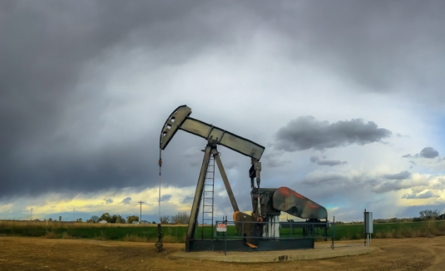
"U.S. Oil Exports Skyrocket Despite Climate Pacts"
"Seven years ago, the U.S. exported its crude oil to just one country — Canada. This year, 22 countries received American crude oil, marking a more than 1,000 percent increase in U.S. oil exports since 2009, according to U.S. Department of Energy data released this week. Since Congress lifted restrictions on American oil exports a year ago, more and more U.S. crude oil has been streaming onto the global oil market to supply the world’s growing demand. It’s happening even as the U.S. and Canada have agreed to cut emissions from oil and gas operations and countries agree to cut their greenhouse gas pollution under the Paris Climate Agreement. The international pact aims to prevent global warming from exceeding 2°C (3.6°F)."
See more from Climate Central HERE:
(An oil well in Colorado. Credit: C.L. Baker/flickr)
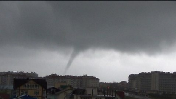
"Small tornado hits Russia's Olympic city Sochi"
Sochi was home to many Olympic athletes during the 2014 Winter Olympics. Interestingly, a small tornado ran through the city as storms recently pushed through the region. See more from BBC below.
"A small tornado descended on Russia's Olympic city Sochi as stormy weather battered the coastline."
See more from BBC HERE:
"Space Farming: NASA Tests New Harvest Technique To Increase ISS Crop Yield"
Fresh salad in space? Sure! Here's an excerpt from IBTimes on how astronauts are growing plants on the International Space Station.
"NASA astronauts on board the International Space Station on Friday reaped the first harvest of red romaine lettuce leaves grown on the orbiting space lab last month. These vegetables were grown using the "Veggie" plant growth system on the ISS, and were harvested as part of a technique the space agency calls "cut-and-come-again." "Cut-and-come-again is a repetitive harvest technique in which a selection of leaves can be harvested for a bit of fresh lettuce and possibly science samples," NASA explained in a statement. "The remaining leaves and the core of the plant are left intact and will continue to grow and produce more leaves for subsequent harvests approximately every 10 days." The goal of this technique is to improve the yield of crops being grown in the micro-gravity environment of space, where plant roots grow every which way, making it excruciatingly difficult for them to absorb the nutrients and water they need to survive."
See more from IBTimes HERE:
(An artist's concept showing plants being grown in space. Photo: NASA)

Thanks for checking in and don't forget to follow me on Twitter @TNelsonWX

No comments:
Post a Comment