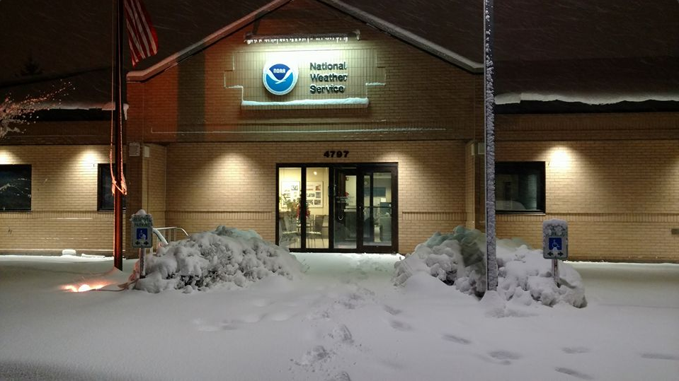
Fresh Snow in Grand Forks
Take a look at the wintry scene from the National Weather Service in Grand Forks, ND after recent heavy snowfall from earlier this week. Some spots from eastern ND to northwestern MN saw up to 8" to 15" with near whiteout conditions thanks to 40mph to 50mph wind gusts. Heavy snow and gusty winds will begin to taper through the second half of the week.
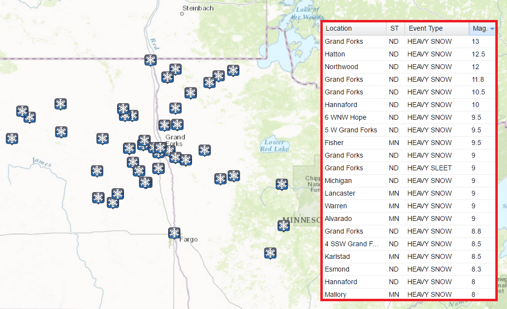
Snowfall Tallies
Here are some of the heavy snowfall reports that have come in from eastern North Dakota and parts of northwestern MN. Note that a few locations near Grand Forks have seen up to 12" of snow already!
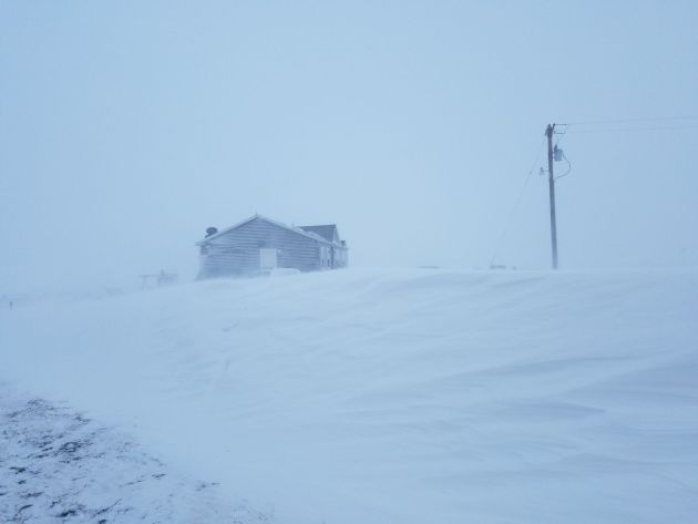
Blizzard Conditions Fade
Thanks to Coby Hubble for this picture out of northwestern ND as fresh snow and strong winds created blizzard conditions for much of the day Tuesday. Breezy winds on Wednesday will still create areas of blowing snow where heavy snow has fallen.
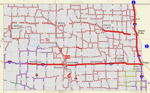
 North Dakota Road Conditions
This is a look at the North Dakota road conditions, which still showed many closed roads or no travel advised across much of the state as of PM Tuesday.
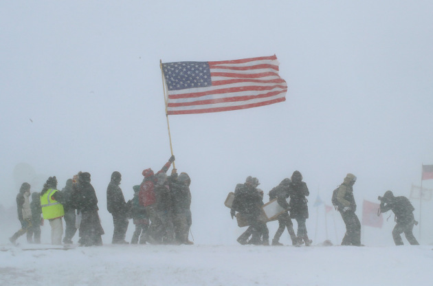
 ____________________________________________________________________________"Standing Rock Sioux leader tells protesters to go home as blizzard hits"
The blizzard that impacted much of North Dakota and northwestern Minnesota also impacted protesters that have gathered to block the construction of the oil pipeline. Here's an excerpt from IBTimes:
"A blizzard hit the North Dakota camp where thousands of protesters have gathered to block the construction of an oil pipeline. A blizzard has hit the North Dakota camp where thousands of veterans and environmentalists have gathered to block the construction of an oil pipeline. Heavy snow, whipped up by 40mph (64km/h) winds, blasted through the tipis and tents, causing white-out conditions. After a relatively warm autumn, this was the first serious storm of the winter, with temperatures dropping to minus nine degrees Celsius (15F)."
See more from IBTimes HERE:
(Scott Olson/Getty Images)
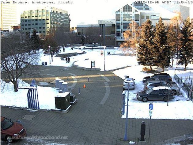
 ___________________________________________________________________Anchorage, Alaska
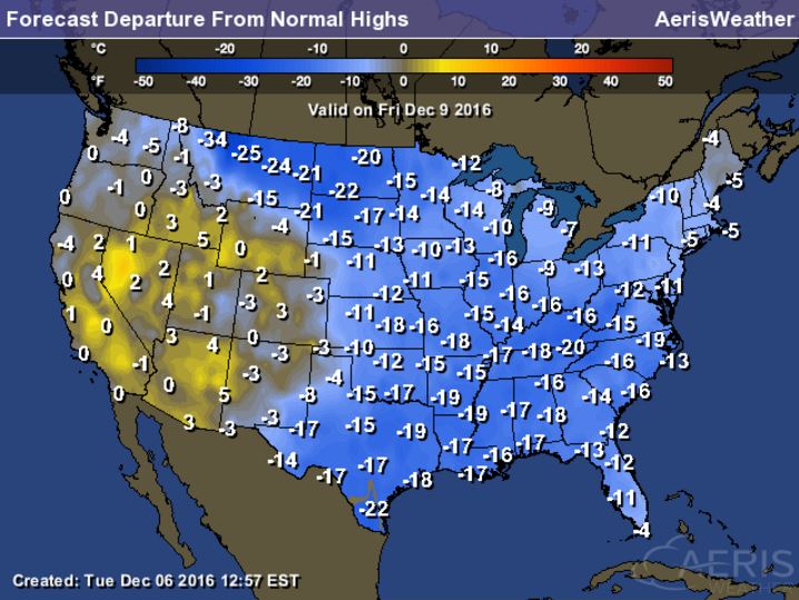
Here's that blob of Arctic as it continues to spread through the eastern half of the country through the rest of the week. Many locations will dip to near 10F to 20F+ below average levels, which will likely be some of the coldest air of the season.
_________________________________________________________________________
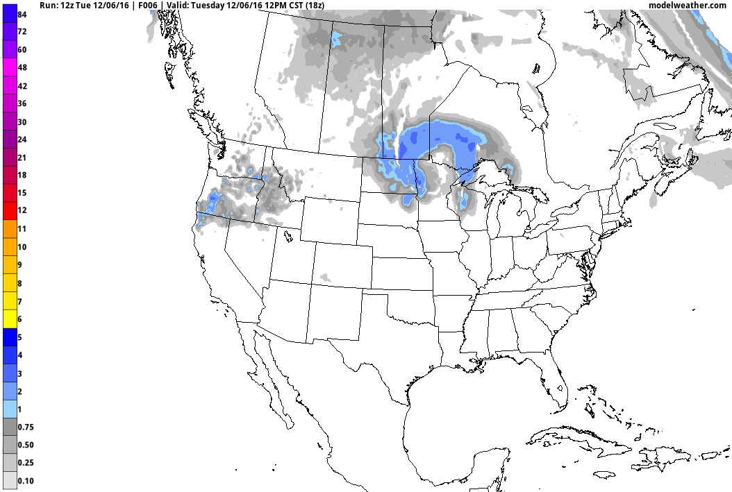
84-Hour Outlook
Here's the national weather outlook through the end of the week, which shows heavy snow across the Upper Midwest tapering a bit with Lake effect snow developing across the Great Lakes Region through the end of the week. The next surge of Pacific moisture begins to slide into the Western US with heavy rain along the coast and heavy snow in the high elevations.
.gif)
Take a look at the wintry scene from the National Weather Service in Grand Forks, ND after recent heavy snowfall from earlier this week. Some spots from eastern ND to northwestern MN saw up to 8" to 15" with near whiteout conditions thanks to 40mph to 50mph wind gusts. Heavy snow and gusty winds will begin to taper through the second half of the week.
Snowfall Tallies
Here are some of the heavy snowfall reports that have come in from eastern North Dakota and parts of northwestern MN. Note that a few locations near Grand Forks have seen up to 12" of snow already!
Blizzard Conditions Fade
Thanks to Coby Hubble for this picture out of northwestern ND as fresh snow and strong winds created blizzard conditions for much of the day Tuesday. Breezy winds on Wednesday will still create areas of blowing snow where heavy snow has fallen.
This is a look at the North Dakota road conditions, which still showed many closed roads or no travel advised across much of the state as of PM Tuesday.
The blizzard that impacted much of North Dakota and northwestern Minnesota also impacted protesters that have gathered to block the construction of the oil pipeline. Here's an excerpt from IBTimes:
"A blizzard hit the North Dakota camp where thousands of protesters have gathered to block the construction of an oil pipeline. A blizzard has hit the North Dakota camp where thousands of veterans and environmentalists have gathered to block the construction of an oil pipeline. Heavy snow, whipped up by 40mph (64km/h) winds, blasted through the tipis and tents, causing white-out conditions. After a relatively warm autumn, this was the first serious storm of the winter, with temperatures dropping to minus nine degrees Celsius (15F)."
See more from IBTimes HERE:
(Scott Olson/Getty Images)
If you've been following the weather over the past couple of years in Alaska, it has been pretty warm. The colder weather moving into the Lower 48 has also been blowing across Alaska with some of the coldest air some locations have seen in a long time. Anchorage, Alaska recently dropped to 0F on Monday, ending it's 2nd longest streak between 0F days. at 383 days! The longest stretch between 0F days was 682 days, which ended on November 29th, 2001.
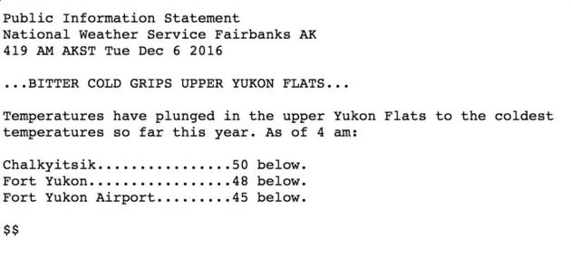
First -50F in North America!! Drum Roll Please...
The first -50F of the season goes to Chalkyitsik on the Upper Yukon Flats in Alaska! It was measured early Tuesday morning.
 ___________________________________________________________________________
Arctic Air Plunges into the Lower 48
___________________________________________________________________________
Arctic Air Plunges into the Lower 48
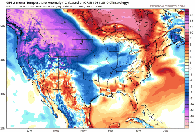
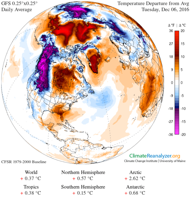
Part of the same Arctic air mass that brought bitter cold to parts of Alaska is now plunging into the Lower 48. The image below shows the temperature anomaly from Tuesday, December 6th and note the bright purple from Alaska into the northwestern part of the US. This denotes MUCH cooler than average temperatures. This is the chunk of Arctic air that will continue to surge south into the Lower 48 through the rest of the week.
Arctic Air Surges South
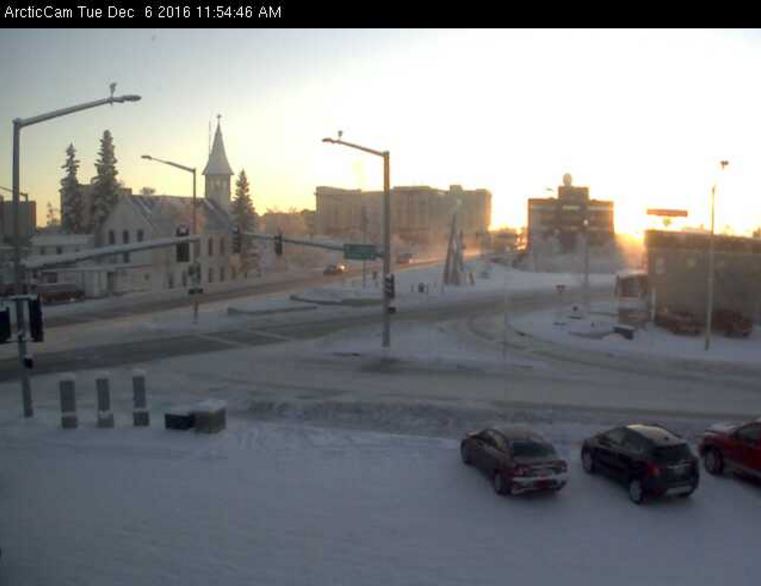
Fairbanks, Alaska
Another interesting stat came out of Fairbanks, Alaska where temperatures dipped to -35F on Sunday, which was the first time in 2 winters! Interestingly, Fairbanks average 12 days per year with a low temperature at -35F or colder! A.) it's crazy that they average that many days per year with a temperature that cold, but B.) it's crazy that Sunday's -35F low temp was the first time that it's happened in 2 winters! Good grief.First -50F in North America!! Drum Roll Please...
The first -50F of the season goes to Chalkyitsik on the Upper Yukon Flats in Alaska! It was measured early Tuesday morning.
___________________________________________________________________________Part of the same Arctic air mass that brought bitter cold to parts of Alaska is now plunging into the Lower 48. The image below shows the temperature anomaly from Tuesday, December 6th and note the bright purple from Alaska into the northwestern part of the US. This denotes MUCH cooler than average temperatures. This is the chunk of Arctic air that will continue to surge south into the Lower 48 through the rest of the week.
Here's that blob of Arctic as it continues to spread through the eastern half of the country through the rest of the week. Many locations will dip to near 10F to 20F+ below average levels, which will likely be some of the coldest air of the season.
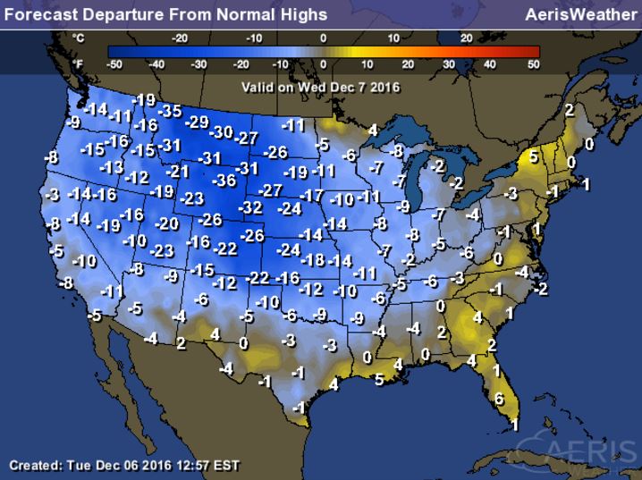
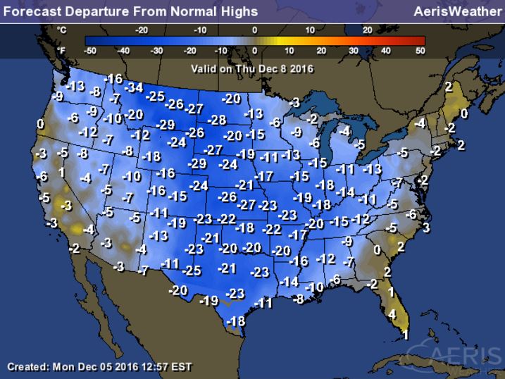
High Temperatures From Average on Wednesday through Friday
Here's a look at high temperatures from average across the nation Wednesday through Friday and note that many locations will be nearly 10F to 20F colder than average! Some spots along the Front Range of the Rockies could be nearly 30F below average then... BRR!
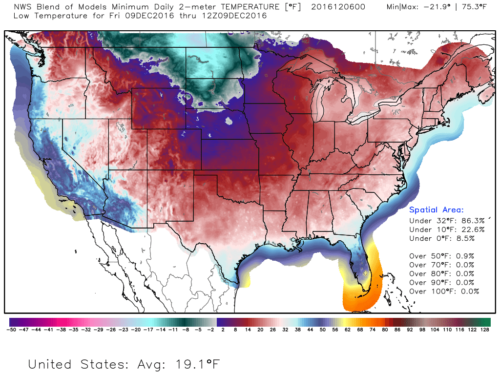
Much of the Nation Below Freezing Friday Morning
Friday morning appears to be the most widespread (cold) morning of the week with nearly 86% of the nation seeing low temperatures below freezing! The coldest air will be found in the High Plains where some spots across North Dakota could drop into the teens below zero! Wind chills there could be in the 20s below zero by Friday morning too!
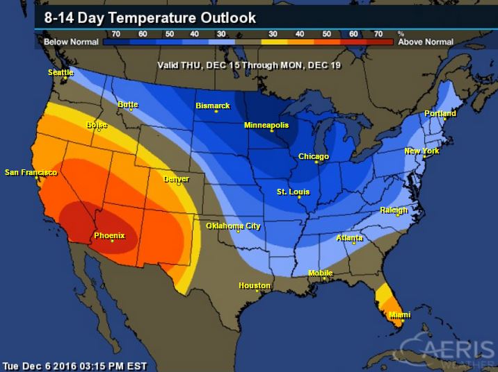
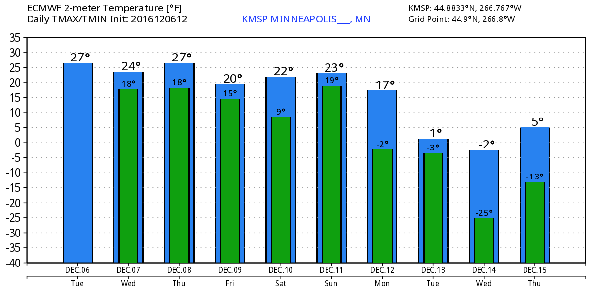
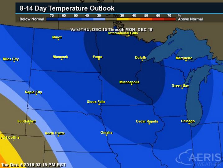
8 to 14 Day Temperature Outlook
If you like the colder, wintry weather, you're in luck! According to NOAA's Climate Prediction Center, the 8 to 14 day temperature outlook suggests that colder than average temperatures will be with much of us in the eastern half of the country. The coldest of which will be found across the Upper Midwest and Great Lakes Region. With that said, look for several bouts of lake effect snow over the next couple weeks.
_________________________________________________________________________
Here's the national weather outlook through the end of the week, which shows heavy snow across the Upper Midwest tapering a bit with Lake effect snow developing across the Great Lakes Region through the end of the week. The next surge of Pacific moisture begins to slide into the Western US with heavy rain along the coast and heavy snow in the high elevations.
10-Day Snowfall Outlook
Here's the 10 day snowfall potential, which initially shows heavier snow ongoing across the Upper Midwest and translating into heavier lake effect snow across the Great Lakes Region. The next surge of Pacific moisture will bring heavy snow to the high elevation. As this next surge of Pacific moisture moves inland, it appears that some across the Midwest may be in for some additional accumulating snow by the weekend.
Here's the 10 day snowfall potential, which initially shows heavier snow ongoing across the Upper Midwest and translating into heavier lake effect snow across the Great Lakes Region. The next surge of Pacific moisture will bring heavy snow to the high elevation. As this next surge of Pacific moisture moves inland, it appears that some across the Midwest may be in for some additional accumulating snow by the weekend.
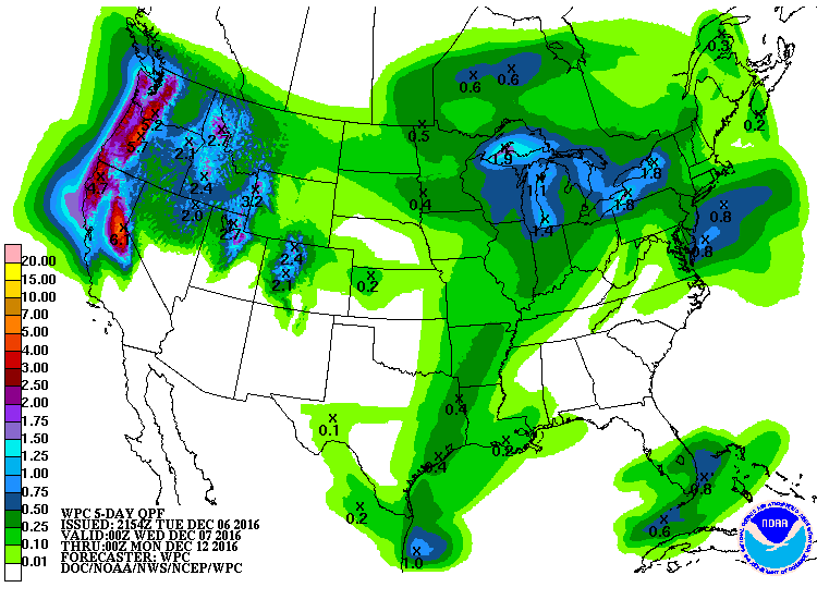
5 Day Precipitation Outlook
According to NOAA's WPC, the 5 day precipitation outlook suggests heavy precipitation in the Western US, especially along the coast in the higher elevations. Some spots could see as much as 3" to 6"+ liquid through the end of the weekend. Also note the heavy moisture around the Great Lakes, which will fall in the form of heavy lake effect snow over the next several days!
______________________________________________________________________________
And just like that, the other shoe dropped! We all knew it would at some point, right? At any rate, let's welcome back Old Man Winter from his extended summer vacation. There are a few hecklers in the back booing. Apparently they aren't fans of face numbing wind chills and white knuckle driving. However, there are many Minnesotans that embrace the winter chill; your sweet spot has finally arrived!
An Arctic front blasted through Tuesday morning with gusty winds and single digit wind chill values. Not even sure I was ready for it. Time to dig out the heavy winter artillery.
Nearly a foot of snow and blizzard conditions taper across most of North Dakota and northwestern MN today. Gusty winds, nippy wind chills and scattered light snow showers continue through Thursday.
We'll have a few days to settle into temperatures that will be nearly 10 to 15 degrees below average before our next snow event moves in late Saturday.
Extended models suggest shoveling duties by Saturday night. Maybe even snowblower worthy? Stay tuned
___________________________________________________
Extended Weather Outlook
TUESDAY NIGHT: Mostly cloudy, breezy and colder. Winds: W 15-30. Low: 16.
WEDNESDAY: Mostly cloudy with a few flakes. Breezy, single digit wind chills. Winds: W 15-30. High: 22.
WEDNESDAY NIGHT: Scattered light snow showers develop late. Winds: 15-30. Low: 14.
THURSDAY: Chilly breeze. Scattered light snow. Winds: NW 10-20. High: 22.
FRIDAY: Hazy sunshine. Less wind, still cold. Winds: WNW 5-10. Wake-up: 9. High: 19.
SATURDAY: Dry AM. Shovelable snow overnight? Winds: SE 5-15. Wake-up: 12. High: 24.
SUNDAY: AM snow, cold wind returns. Winds: NW 10-20. Wake-up: 19. High: 25.
MONDAY: Nippy wind chills. Few flakes. Winds: W 5-10. Wake-up: 12. High: 16.
TUESDAY: Heavy coat worthy. Light snow possible. Winds: W 10-20. Wake-up: 8. High: 14.
_______________________________
_______________________________
This Day in Weather History
December 7th:
1982: Due to unseasonably mild temperatures during the preceding weeks, a farmer near St. Bonifacius is able to bail his 4th crop of alfalfa hay on this day.December 7th:
1927: A blizzard hits the Arrowhead region with heavy snows and 70 mph winds at Duluth.
________________________________
Average High/Low for Minneapolis
December 7th
Average High: 30F (Record: 54F set in 1939)
Average Low: 15F (Record: -20F set in 1972)
Average Low: 15F (Record: -20F set in 1972)
Record Snowfall: 6.3" set in 1927
_________________________________
_________________________________
Sunrise/Sunset Times for Minneapolis
December 7th
December 7th
Sunrise: 7:37am
Sunset: 4:32pm
Sunset: 4:32pm
*Daylight Lost Since Yesterday: ~1mins & 6sec
*Daylight Lost Since Summer Solstice: ~6hours and 40mins
______________________________________________________________________
*Daylight Lost Since Summer Solstice: ~6hours and 40mins
______________________________________________________________________
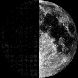
Moon Phase for December 6th at Midnight
0.1 Days Before First Quarter
0.1 Days Before First Quarter
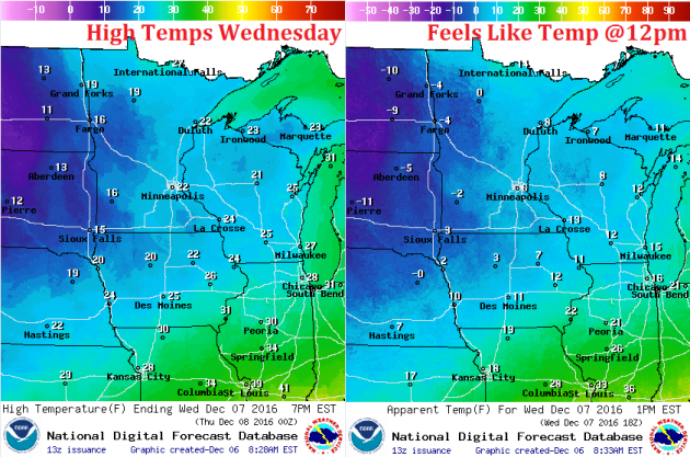
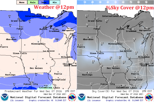
Weather Outlook Wednesday
High temperatures on Wednesday won't be any warmer than they were on Tuesday afternoon. In fact, wind chill values for much of the day will be in the single digits above and below zero! BRR!
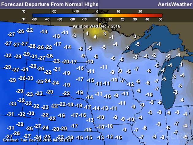
High Temperatures From Average Wednesday
Here's a look at high temperatures from average on Wednesday, which shows WELL below average temps across much of the region in the wake of our Arctic cold front. Note that readings across the Dakotas will be nearly 30F below average in spots.
Weather Outlook Wednesday
Winds will be very strong across the state again on Wednesday with sustained winds at 10mph to 20mph and wind gusts up to 30mph+. This will help to keep brisk wind chills and blowing snow in play for much of the day.
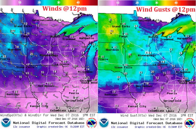
Weather Outlook Wednesday
The weather outlook for Wednesday suggests scattered snow showers continuing across the northern half of the state. Note that steadier heavier snow will be found along the international border, while lighter snow showers and flurries will be found farther south.
___________________________________________________________
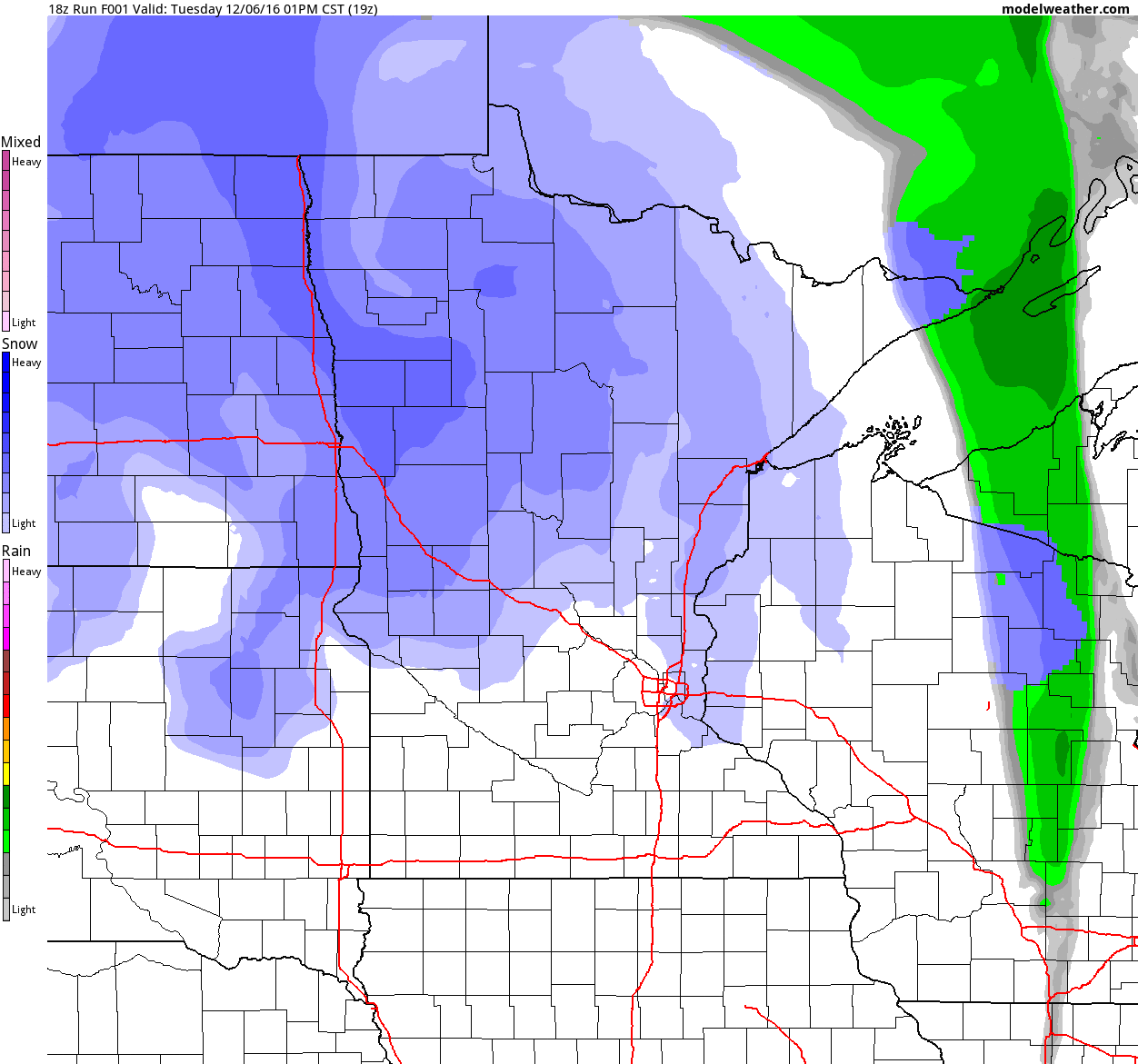
Simulated Radar
The simulated radar from Tuesday to Friday shows the storm system responsible for heavy snow and blizzard conditions across North Dakota and NW Minnesota starting to wind down by the end of the week. Gusty winds and scattered light snow showers will still be possible across much of the state through Thursday before fading a bit more on Friday.
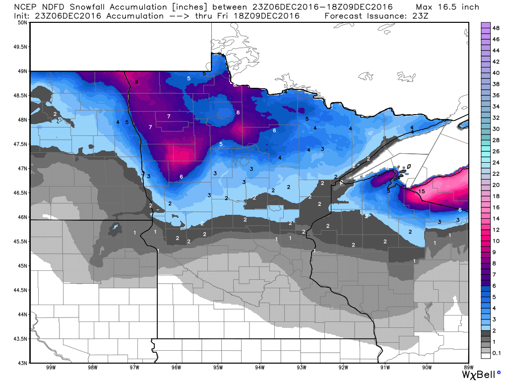
Snowfall Potential
Here's the snowfall potential through Friday, which shows heavy pockets of snow across northern MN as the storm system continues to slowly spin through the region. Note that we don't expect much in the southern half of the state.
Somewhat Active Pattern With Colder Temps Ahead.
Here's the weather outlook through Sunday. Heavy snow and strong winds will fade through the end of the week and transition into heavy lake effect snow across parts of the Great Lakes Region as the cold air settles south. The next system rolls through the Upper Midwest this weekend with the potential of shovelable/plowable for some. Stay tuned!
.gif)
__________________________________________________________________________
Extended Weather Outlook
The temperature outlook for Minneapolis shows colder temperatures continuing over the next several days with the potential of an even bigger cool down during the 2nd full week of December. We may even be looking at our first stint of sub-zero overnight lows!
6 to 10 Day Temperature Outlook
According to NOAA's CPC, the 8 to 14 day temperature outlook suggests colder than average temperatures continuing through the 3rd weekend of December.
___________________________________________________________________________
Wintry Mashup on Montreal Streets
Here's an interesting video from Montreal Canada that shows several cars & buses plowing into each other thanks to very slippery roads. It's almost painful to watch...See the full video from MetroNews.ca HERE:
(Image Credit: Willem Shepherd Via Facebook)

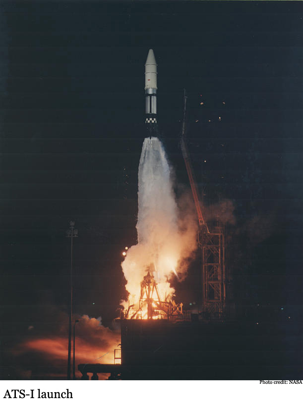
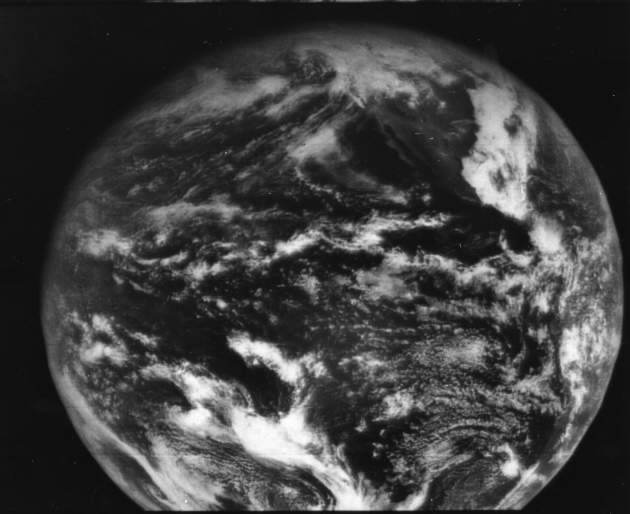
"The 50th Anniversary of ATS-1"
Here's an interesting nugget... it was 50 years ago (December 6th) that our first Earth-observing satellite ever was placed in geostationary orbit and only 5 days later, the first ever full disk image of Earth was taken from geostationary orbit! Pretty neat huh? Now we take satellite images for granted...
See more from NOAA HERE:
"Fifty years ago, at 9:12 p.m. Eastern on December 6, 1966, a NASA Atlas rocket carried the Applications Technology Satellite (ATS-1) to space, becoming the first Earth-observing satellite ever placed in geostationary orbit."
(ATS-1 launched at 9:12 p.m. Eastern on December 6, 1966 aboard a NASA Atlas rocket. Credit: NASA)
_______________________________________________________________________________
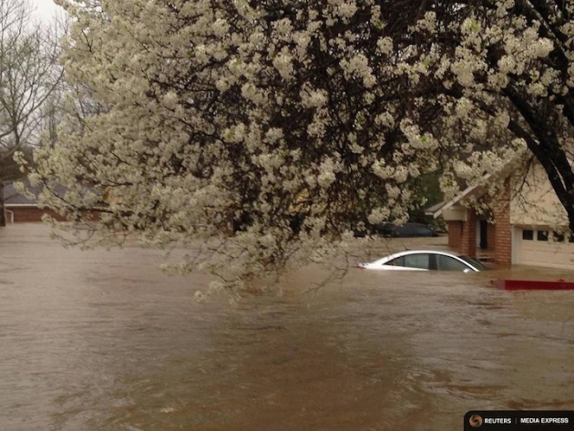
"Warming U.S. Could See Extreme Rains Increase Fivefold"
"When the skies open up and deluge an area, the results can be catastrophic, with roads washed out and homes destroyed by the resulting flash floods. Such extreme downpours are already occurring more often across the U.S., but a new study finds that as global temperatures rise, storms could dump considerably more rain and skyrocket in frequency. The study, detailed Monday in the journal Nature Climate Change, suggests that storms that now occur about once a season now could happen five times a season by century’s end, a 400 percent increase. And when such storms do occur, they could produce up to 70 percent more rain. That means that an intense thunderstorm that would today drop about 2 inches of rain would drop 3.5 inches in the future. Such massive amounts of rain occurring more often could put significant strain on infrastructure that already struggles to deal with heavy rainfall, as seen across the country this year in places from Louisiana to West Virginia."
(A car lies submerged in the Tall Timbers subdivision after flooding near Shreveport, La., on March 9, 2016, caused by torrential rains. Credit: REUTERS/Deputy Josh Cagle/Bossier Parish Sheriff's Office via Reuters)
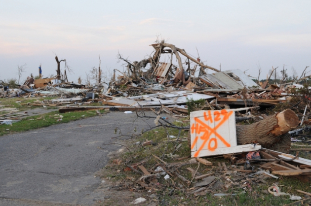
"Extreme Tornado Outbreaks Are Becoming More Extreme"
"Outbreaks of tornadoes — where multiple tornadoes form over an area in just a few hours or days — are responsible for most of the devastating destruction caused by severe weather, and a new analysis has reached a worrying conclusion about the worst of these outbreaks. Outbreaks with many tornadoes are becoming more extreme, particularly the very worst outbreaks, according to a study published Thursday in the journal Science. When researchers looked into what might be causing the trend — and whether it could be linked to expected changes in storm environments due to climate change — they found the opposite of what they expected, pointing to the need for more research on the matter."See more from Climate Central HERE:
(The remnants of a home destroyed by one of the many tornadoes that raked across Alabama during the April 2011 Super Outbreak. Credit: FEMA Photo by George Armstrong)
Thanks for checking in and don't forget to follow me on Twitter @TNelsonWX

No comments:
Post a Comment