33 F. high temperature yesterday in the Twin Cities.
24 F. average high on January 24.
30 F. high on January 24, 2016.
January 25, 1964: A record high temperature of 64 is set at Redwood Falls.
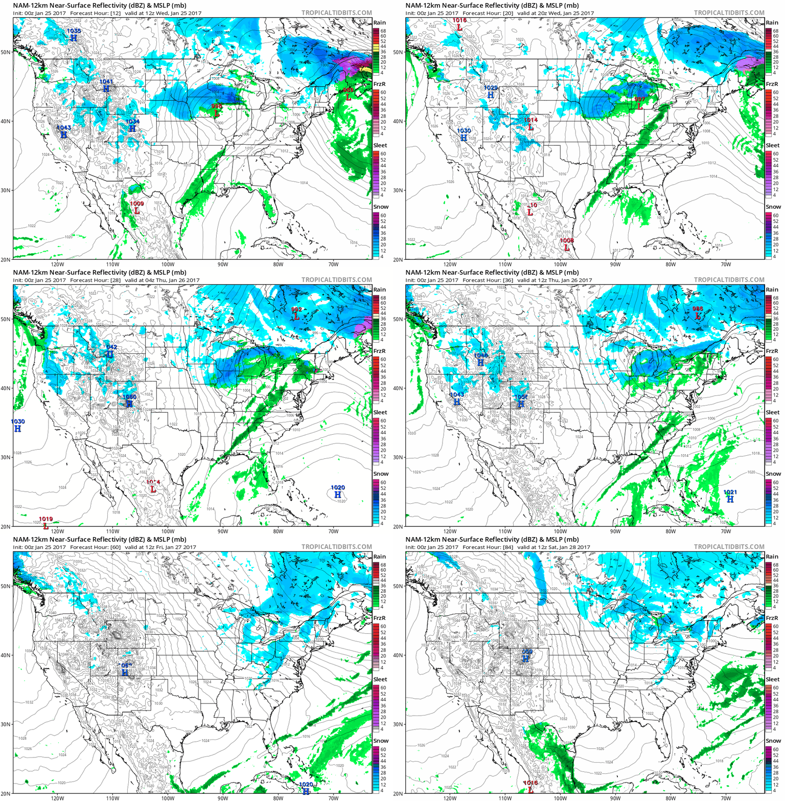 Sideswiped by Snow - Mild Trend Into Next Week
According
to the U.S. Census Bureau Minnesota's population in 2014 was 5.457
million. Which means there should, in theory, be 5.457 million
individual weather forecasts going out. The Internet has disrupted not
only media and countless industries, but weather. The democratization of
data is well underway. No more gatekeepers - now everyone has access to
the web pages and apps they need to stay informed, personalized for
their GPS location, calendars, commutes and wish lists.
No more one-size-fits-all weather.
Issuing
one forecast for the metro on a day like this is an exercise in
futility. Today's "storm" should drop a coating over far northern Anoka
County, while parts of Scott and Dakota county may see plowable amounts
(over 3 or 4 inches). Surface temperatures hold near 32F, meaning many
freeways will stay wet.
Until further notice winter has been
neutered. We cool off slightly later this week, but ECMWF guidance shows
4 or 5 days above freezing next week. Considering it could be -15F
right now I'm counting my atmospheric blessings. Today? A cosmetic
snowfall for most of us.
Animation credit:
Tropicaltidbits.com. NOAA's 12 KM NAM model shows a streak of plowable
snow spreading across southern Minnesota and Iowa into Wisconsin, the
immediate Twin Cities brushed with an inch or two, more south of the
Minnesota River. Lake effect snows kick in later this week as the
atmosphere calms down a bit; a welcome dry spell for the western USA
after a parade of damaging storms.
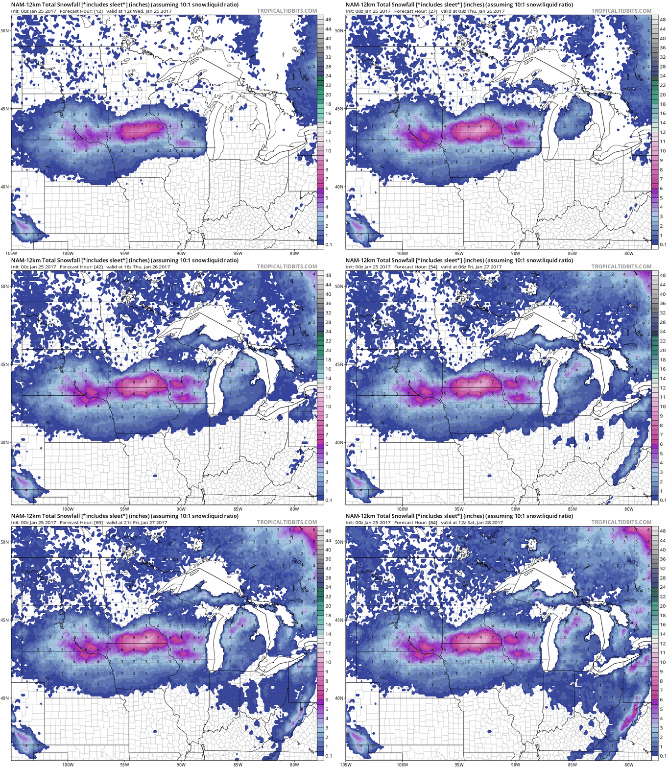 An Urge to Ski Rochester
.
The heaviest snow bands set up over far southern Minnesota along I-90,
where some 6-9" snowfall totals are possible before the flakes subside
later today. So close...
Not Bad For The Dead of Winter.
True, our coldest weather usually comes around January 15-18, but late
January can be brutal. Nothing forbidding is shaping up, at least
looking out 2 weeks, with temperatures consistently above average into
next week; nothing subzero for the MSP metro thru Feb. 7. ECMWF
temperatures: WeatherBell.
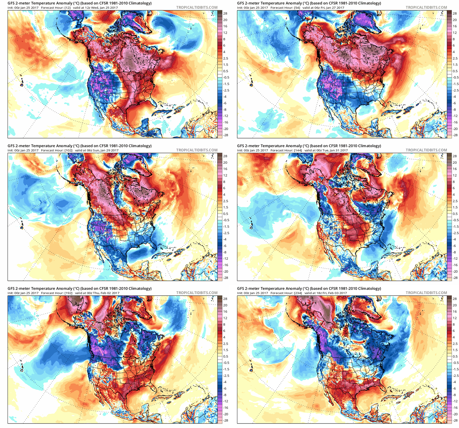 Temperature Anomalies Next 10 Days
.
Here is the (GFS) predicted temperature anomaly into a week from
Friday; much the USA trending milder than average into the first few
days of February. I'm still struck by a lack of consistently bitter air
across Canada - I'll still be amazed if the northern tier of the USA
doesn't see another couple of subzero swipes before March arrives. Loop:
Tropicaltidbits.com.
2-Weeks Out: Fairly Mild and Moderate.
GFS guidance shows the coldest air passing to our north across Canada
with a strong Pacific signal for most of the lower 48 states; unusually
warm weather for the southern USA as we push into February.
California Has The Snow. It Just Needs To Keep It Frozen.
Rain is a quick withdrawl, snow is money in the bank, paying long-term
dividends for thirsty towns and farms. Here's an excerpt from
The Los Angeles Times: "...
It’s
certainly deeper than anything we’ve seen in the last five years,” said
state climatologist Michael Anderson. Experts and officials, however,
say that long-term warming trends are likely to complicate how
California manages its water supply. Temperatures in the Sierra have
been rising in the last few decades, which will pose problems for
storing ice in the mountains during the winter and spring. Rain has also
become more likely at higher elevations over the years, meaning more
precipitation is falling as liquid, not snow. Water is also running off
into reservoirs earlier, a reflection of more rain falling in the
mountains or snow melting closer to wintertime instead of the spring..."
What Experts Think of Speculation That El Nino Will Return in 2017.
Good question, considering the current pattern looks more like the
symptoms of El Nino vs. La Nina. Dr. Marshall Shepherd sorts out the
signal from the noise at
Forbes: "...
He
also pointed out that the likelihood of La Niña following a strong El
Niño (like this year) is much higher than El Niño following La Niña. Dr.
Klotzbach is well-known for his seasonal hurricane forecasts but is
also an expert on many aspects of tropical meteorology and climatology.
He points out,
While it would certainly be
unusual to have another El Niño so quickly on the backs of a previous
one, the last El Niño didn't dissipate as much heat from the equatorial
Pacific as the past two major ones (e.g., 1982 and 1997)...I would be
pretty surprised if we got a full blown East Pacific El Niño event again
in 2017, but I think that another Central Pacific (aka Modoki) event is
possible..."
Graphic credit: "
Oceanic Nino Index. Courtesy of Jan Null's website with data from NOAA."
Despite Tornado Threat Shelters Rare for Mobile Home Parks.
I'm amazed there are no laws requiring underground shelters for mobile
home parks. Am I missing something here? Mobile home operators don't
want to spend the money to protect their residents - but should this be
optional?
US News has a timely story: "
Ten
of at least 20 people killed in a weekend tornado outbreak lived in
Georgia mobile home parks, yet laws requiring storm shelters in those
vulnerable communities are few and far between. Experts have long warned
that mobile home dwellers face a higher risk of death when tornadoes
strike but said many trailer park owners don't want to make the costly
investment in storm shelters and the sentiment for safety wanes in the
weeks after a disaster. According to the National Weather Service, 44
percent of the 1,091 Americans killed by tornadoes from 1985 to 2005
died in mobile homes, compared to 25 percent in stick-built homes.
That's especially significant considering how few Americans — 8 percent
or fewer — lived in mobile homes during that period..."
File photo: "
In
an Oct. 22, 2015 photo, David A. Roden, owner of Mountain View Estates,
speaks about a tornado shelter that he built for his mobile home park
residents in Rossville, Ga. Experts have long warned that people in
mobile homes face a greater risk of death from tornadoes, yet laws
requiring storm shelters in trailer parks or public spaces such as
schools are few and far between. Roden believes he is the first park
owner in the southeast to offer residents a storm shelter." (Dan Henry/Chattanooga Times Free Press via AP) /Chattanooga Times Free Press via AP)
The Associated Press.
Weekend Tornado Swarm: Second Deadliest January Outbreak on Record. So says News4Jax in Jacksonville:
- 2nd Deadliest January tornado outbreak in U.S. History
- Deadliest tornado outbreak in South Georgia
- Third deadliest tornado outbreak in Georgia history
And
these are just preliminary numbers, not known yet is the number of
homeless and homes destroyed, total dollar loss and potential economic
loss to Adel and Albany, Georgia....
Weekend Tornado Death Toll Exceeds All of 2016. There is disagreement about the total number of tornadoes from the most recent outbreak. CNN and
KXLY.com say 41; here are the grim details: "
The
Southeast picked up the pieces on Monday after deadly tornadoes tore
through the region, killing more people in one weekend than in all of
last year, and officials called out for the federal government to
urgently help their devastated communities. At least 41 reported
twisters ravaged the southern states over the weekend, killing 19 people
and destroying homes, CNN meteorologists reported. Tornadoes were
reported in Louisiana, Mississippi, Alabama, Georgia and South Carolina.
In 2016, tornadoes left 17 people dead across the country..."
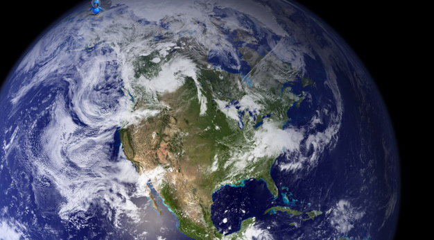
NOAA's GOES-16 Satellite Sends First Images of Earth.
The full disk above was taken on January 15. Meteorologists (myself
included) are very excited about the enhanced imagery and lightning data
about to become available via GOES-16. Here's an excerpt from
NOAA: "...
The
pictures from its Advanced Baseline Imager (ABI) instrument, built by
Harris Corporation, show a full-disc view of the Western Hemisphere in
high detail — at four times the image resolution of existing GOES
spacecraft. The higher resolution will allow forecasters to pinpoint the
location of severe weather with greater accuracy. GOES-16 can provide a
full image of Earth every 15 minutes and one of the continental U.S.
every five minutes, and scans the Earth at five times the speed of
NOAA’s current GOES imagers. NOAA’s GOES-16, situated in geostationary
orbit 22,300 miles above Earth, will boost the nation’s weather
observation network and NOAA’s prediction capabilities, leading to more
accurate and timely forecasts, watches and warnings..."
GOES-16 Image Gallery. Test imagery for CONUS and the full disk is available
here.
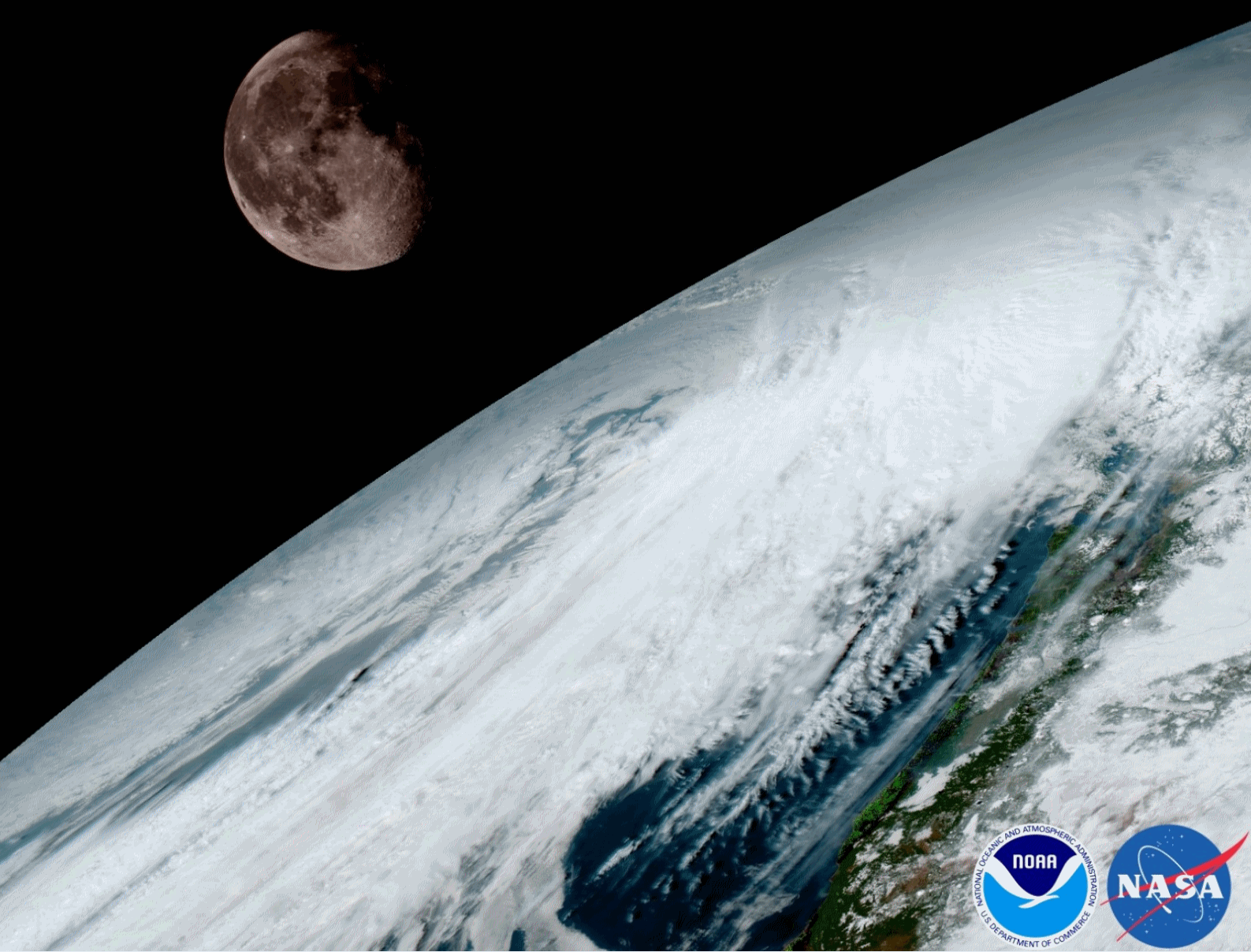 The First From the New Weather Satellite Just Arrived, and They're Absolutely Incredible
. Angela Fritz reports for
Capital Weather Gang: "
The
satellite formerly known as GOES-R (so Prince, right?) has transmitted
its first images back to Earth, and they are flooring. From the details
on the face of the moon to the incredible resolution of cumulus over the
Caribbean, these first pixels portend a sunny future for NOAA’s new
GOES-16 satellite. Meteorologists are drooling. This release coincides
with the first day of the American Meteorological Society’s annual meeting.
There are thousands of weather geeks in Seattle this week, and — at
least on Monday — they’re all looking at this next-gen satellite
imagery. As we’ve written before, GOES-R satellite has six instruments,
two of which are weather-related. The Advanced Baseline Imager,
developed by Harris Corp., is the “camera” that looks down on Earth. The
pictures it sends back will be clearer and more detailed than what’s
created by the current satellites..."
Image credit: "
GOES-16
captured this view of the moon, as it looks across the Pacific
Northwest on Jan. 15. As with earlier GOES spacecraft, GOES-16 will use
the moon for calibration." (NOAA/NASA).
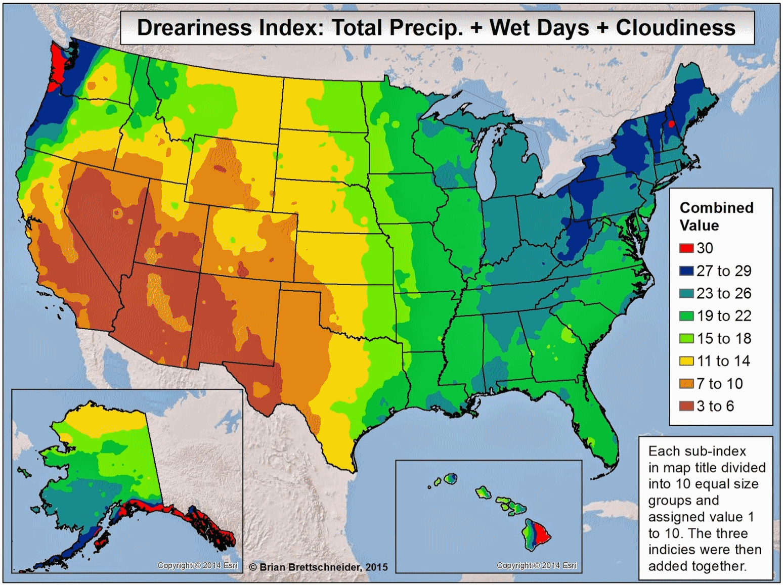 The Dreariness Index
.
My thanks to climate guru Brian Brettschneider (based in Alaska) for
whipping together a useful index that combines total precipitation, wet
days and average cloud cover to create one index that summarizes how
gray/damp a specific part of the USA is. Here's an excerpt from
Brian's post: "
In
previous posts, I have looked at total rainfall, number of wet days,
and cloud cover independently of one another. Now seems like a good time
to combine these variables to come up with a single composite value.
Three different variables are used in this analysis to come up with
Dreary Index – total annual precipitation, number of days per year with
measurable precipitation, and average annual cloud coverage. An inverses
distance weighted surfacing technique was used to generate a gridded
data set for the entire U.S. for each of the three variables..."
Best Practices for Publicly Sharing Weather Information Via Social Media.
Fake news - fake weather; a lot of armchair meteorologists are posting
information that is misleading and potentially harmful. The
AMS
(American Meteorological Society) has a post addressing this issue.
Remember to follow trusted sources of weather information, preferably
meteorologists vs. some guy living in his mother's basement with a
hyperactive Twitter account: "...
The American Meteorological Society
(AMS) has a long history of encouraging the effective and appropriate
dissemination of weather information while serving as a beacon of
responsible forecasting practices. Today there are more sources of
weather information than ever before. The development of social media
has made it possible for false or misleading weather information to
drown out messages from government agencies, traditional media outlets,
and commercial and academic-based providers. The Society recognizes the
need to maintain the quality of weather information on all platforms
available to the public while encouraging new services to meet the needs
of the public..."
Image credit:
iweathernet.com.
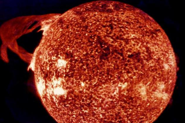
Researchers Calculate Economic Cost of Major Solar Storm, And It's Big.
One more reason to have solar power, to not be completely dependent on a
creaky grid that's vulnerable to malware and X-class solar flares.
The Christian Science Monitor reports: "
Electricity blackouts caused by solar storms could cost the United States tens of billions of dollars per day, according to a new study
published in the journal Space Weather. These researchers were not the
first to calculate the price of solar storms. But scientists in the past
have focused only on the economic costs within the blackout zone –
which amounts to just 49 percent of the total potential cost when
indirect domestic and international supply chain losses are factored in.
Under the most extreme blackout scenario calculated, which would affect
66 percent of the US population, the daily domestic economic loss could
total $41.5 billion, plus an additional $7 billion loss through the
international supply chain..." (Image credit: NASA).
To Fight Coastal Damage, Louisiana Parishes Pushed to Sue Energy Industry.
NPR has the story: "...
An
oil and gas state, Louisiana has long relied on money from offshore
sales to fund part of its budget. But the $90 billion price tag will
require support from Congress. That's why the state's new Democratic
governor, John Bel Edwards, is urging officials like McInnis to sue oil
and gas companies for that damage. "Before we can ever have any hope of
asking taxpayers around the country to come to Louisiana and help us
restore our coast, we have to be able to show them that we did
everything that we could, reasonably, that is within our power," Edwards
says. "And certainly, you can't do that if you don't hold those people
accountable who damaged the coast to begin with." Edwards has said all
the coastal parishes should file suits, or he'll do it for them..." (Image credit:
YouTube).
From Sunlight to Service. Kruse Motors in Marshall is saving money. That's the thing about renewables: there's a tangible ROI. Here's an excerpt from
Marshall Independent: "...
Although
they are in the same neighborhood as the Red Baron Arena and Marshall
High School, the two rows of solar panels running behind the dealerships
are part of Kruse Motors. Since the beginning of the January, they’ve
been helping to generate electricity for Kruse Ford Lincoln and Kruse
Buick GMC. “For us, it’s a huge cost savings,”
Westman said. Being more energy-efficient also helps make it easier to
provide services to customers, like the car wash at the Kruse Ford
Lincoln dealership, she said. Construction for the solar panels started
in fall 2016. Novel Energy Solutions, a Minnesota-based solar company,
installed a 189-kilowatt solar system for Kruse Motors..."
Photo credit: Deb Gau. "
Construction
for a new solar panel system at Kruse Motors in Marshall started this
past fall. The 189-kilowatt system will help provide electricity for two
auto dealerships, and cut down on energy costs."
Xcel Commissions 62.25 MW Minnesota Solar Farm. Here's a clip from
pv magazine: "
Since a 2009 installation on St. John’s Abbey
in Collegeville, Minnesota has often been home to the Midwest’s largest
solar farms. In 2016, it is now home to the two largest solar projects
in the region. Xcel Energy, one of the Midwest’s biggest utilities, announced last week that the Marshall Solar Energy Project,
a 62.25 MW facility near Marshall, Minn., began operations and will
provide enough electricity to power approximately 15,000 Upper Midwest
homes. The utility is purchasing the produced power under a 25-year
power-purchase agreement (PPA)..."
Republican Political Donors Install Nearly as Much Solar as Democratic Donors. When it comes to solar power, political affiliation just doesn't matter, according to a story at
Greentech Media: "...
But
there is growing evidence that -- at least when it comes to clean
energy -- there is a wide chasm between the policy positions the
president supports and what many of his Republican supporters actually
believe. Throughout the campaign, Trump ignored clean energy and focused
mostly on promoting coal, oil and gas. But as reputable political
surveys have shown, Republican voters actually want more support of renewable energy over fossil fuels. And they are proving that with their wallets, too. That is one of the most intriguing findings in a new study by PowerScout, an Oakland-based company that uses data to assist consumers who are considering going solar..."
10 Trends Shaping The Electric Utility Industry in 2017.
Utility Dive has the story: "
At the time of our last trend forecast list in
September 2015, the utility industry was already being
disrupted: Customer demand for distributed resources and the push for
cleaner electricity were reshaping centralized fossil fuel-based grids
across the country to accommodate variable renewables and customer-sited
resources. Those trends toward a
two-way, decarbonized grid are still very much in play at the beginning
of 2017. Lower prices for wind and solar energy have seen those
resources reach grid parity across much of the nation, and utilities
continue to add flexible natural gas generation along with new
technologies like energy storage to integrate the intermittent resources
coming online..."


TODAY: Winter Weather Advisories south metro. Snow tapers to flurries 1-2" slushy snow (more southern suburbs). Winds: N 10-20. High: 33
WEDNESDAY NIGHT: Flurries, a few slick spots. Low: 24
THURSDAY: Mostly cloudy, breezy and cooler. Winds: NW 10-15. High: 29
FRIDAY: More clouds than sun, brisk. Wake-up: 18. High: 28
SATURDAY: Intervals of sun, fairly quiet. Winds: NW 10-15. Wake-up: 19. High: 30
SUNDAY: More sun, trending milder. Winds: NW 8-13. Wake-up: 20. High: 32
MONDAY: Some sun, more vague hints of March. Winds: S 8-13. Wake-up: 21. High: 38
TUESDAY: Mostly cloudy, cooling off a bit. Winds: NW 10-15. Wake-up: 25. High: 35
Climate Stories...
Heat Record: How NASA Knows 2016 Was The Hottest Year. Here's an excerpt from
Live Science: "...
NASA
and NOAA both found a high likelihood that 2016 was the hottest year: a
96 percent chance according to NASA and a 62 percent chance according
to NOAA. The only other contender — with a much lower probability — was
2015. The differing estimates come from different extrapolations of data
about the warming Arctic.
The region has warmed significantly, the panelists said, and how that's
quantified can have a big effect on the average. But overall, the
estimates are very similar, they said..."
Graph credit: "
A
chart released by NASA and NOAA shows global temperature analyses from
several different data sets. They are clearly all "singing the same
song," researchers said.
" Credit: NASA/NOAA.
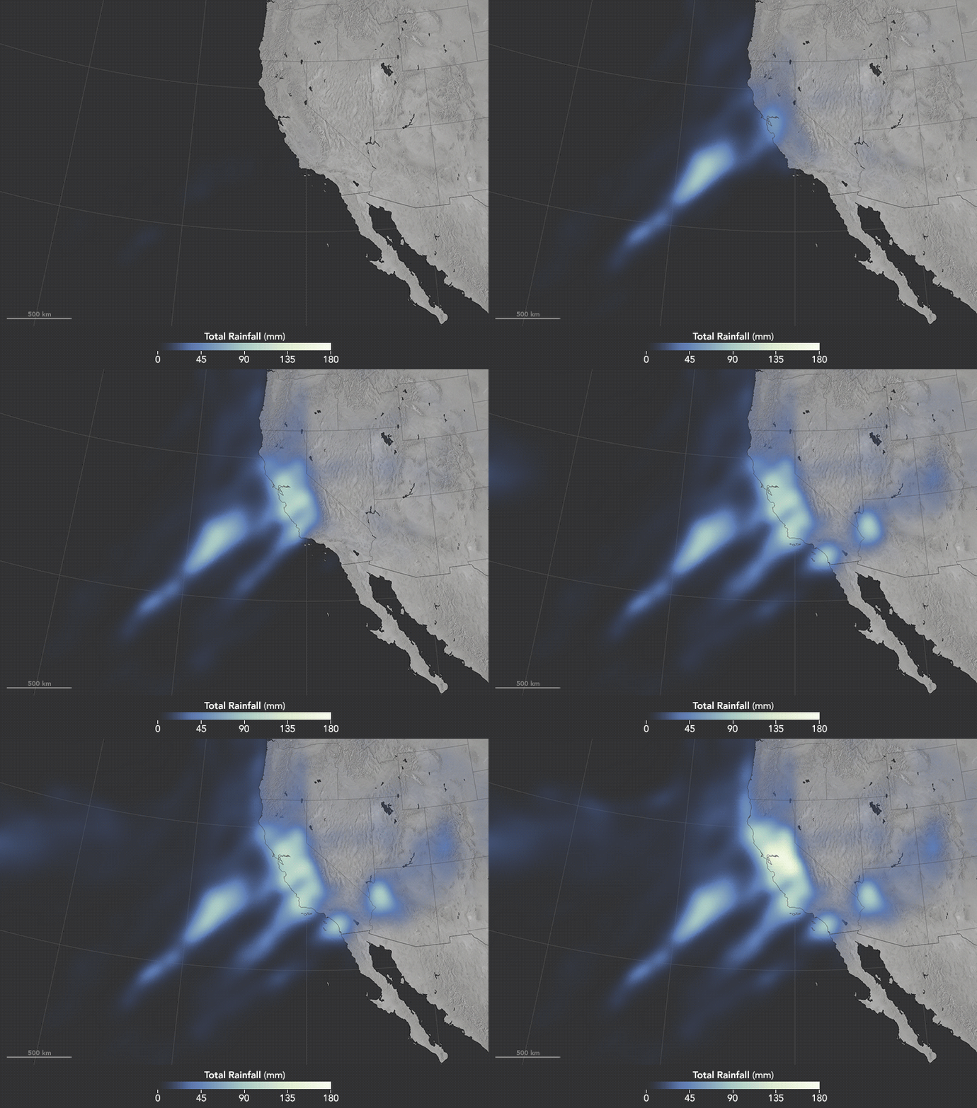
A Climate Paradox: Rising Temperatures To Bring More Droughts and Floods. More climate volatility and weather disruption, according to a story at
Nexus Media: "...
In
isolation, of course not — to date, any modern extreme weather event
would have been possible in pre-industrial times. That said, the
likelihood of a big storm — or a severe heat wave — has changed a lot.
It’s clear that since the 1950s, over much of the United States, extreme
storms are becoming wetter. We’ve only had one degree centigrade of
global warming. That’s a lot, but it’s nothing compared to what is
coming down the line if we stay on the same greenhouse-gas emissions
scenario that we’re on. By the end of this century, you’re looking at 3
or 4 degrees of warming, which is a planet that no human has ever lived
on. We have no experience with such a planet, and it’s entirely possible
that in such a warmer world, storms that were previously
impossible — and certainly heat waves — will occur..."
Image credit: "
The Pineapple Express brought rain to California this month." Source:
NASA
Toxic Algae May Thrive as Climate and Oceans Warm, Study Says. Here's a snippet from
InsideClimate News: "A newly established link between warmer ocean temperatures and toxin-spawning algae provides the latest sign that
climate change
is causing biological disturbances in the oceans. Scientists tracked
West Coast outbreaks of the planktonic algae back to 1991, finding them
strongly correlated with warm phases of Pacific Ocean cycles. The new
research, published last week in the
Proceedings of the National Academy of Sciences, focused on a single-cell species of phytoplankton called
Pseudo-nitzschia. It
produces domoic acid, which can be fatal to humans if consumed at high
levels by eating shellfish. Domoic acid has also been implicated in mass
die-offs of marine mammals, including sea lions, sea otters, dolphins
and whales..." (File photo credit:
phys.org).
More Than 100 Illinois Architects Publish Open Letter to Trump on Climate Change. Here's an excerpt from
The Chicago Tribune: "...
The
letter advocates that the Trump administration create an even playing
field among all energy sources by providing subsidies for renewable
energy technologies, instead of just for the fossil fuel and nuclear
energy industries. It also asks that the U.S. continue its participation
in the Paris Climate Agreement, from which President Trump has
indicated he may want to retreat. The Trump administration's plan on
energy, called An America First Energy Plan,
has so far focused on the rejection of "burdensome regulations," as
well as tapping domestic energy reserves to lessen the dependence on
foreign oil..." (Image credit:
Wikiwand.com).
Read the letter here.
Is The Weather Great Today? Enjoy It While You Can.
Ongoing warming will almost certainly impact the distribution of what
most people would call "good weather days". Here's an excerpt from
The Washington Post: "...
For
the past three decades, the world has averaged 74 mild days a year. But
by 2035 that will shrink to 70 and then 64 by the last two decades of
the century, according to the study, published in the journal Climatic
Change. Mild weather was defined as a high temperature of 68 to 86
degrees with low humidity and no more than a trace of rain. On average,
the United States will lose nine mild summer days by the end of the
century, although most of that loss is gained back with more mild days
in the winter, spring and fall. The biggest losers will be the tropics
and nearly all of Africa, eastern South America, South Asia and northern
Australia. Rio de Janeiro, on average, will see 40 mild days disappear.
Miami will lose its only mild summer day and nearly a month of spring
and fall mild days by 2100..."
 Study: Real Facts Can Beat "Alternative Facts" If Boosted by Inoculation
. Here's a clip from
The Guardian: "...
According
to inoculation theory, facts are important but by themselves aren’t
sufficient to convince people as long as misinformation is also present.
People also have to be inoculated against the misinformation, for
example through an explanation of the logical fallacy underpinning the
myth. To test the theory, the study authors ran an experiment using a
fact that’s been subjected to a tremendous misinformation campaign: the 97% expert consensus on human-caused global warming. There’s been some debate among social scientists about consensus messaging, with most research suggesting it’s effective and important at convincing people about the importance of climate change..."
Image credit: Tim O'Reilly.
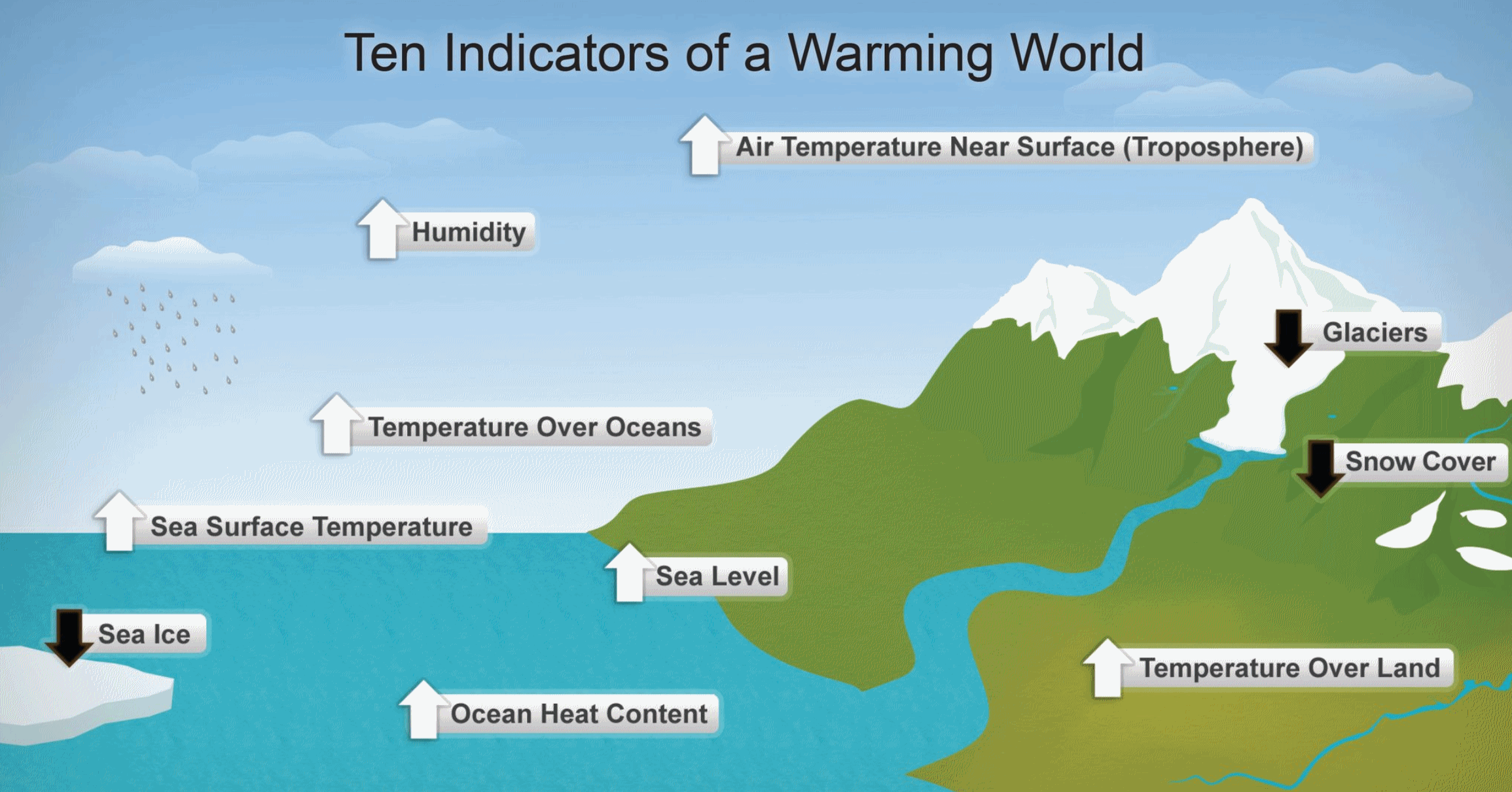 Think Global Warming's a Fraud? These Scientists Want to Change Your Mind.
 Here's an excerpt from
The Columbus Dispatch: "...
In
my opinion, the most convincing piece of evidence for a "discernible
human influence" on global climate is the very distinctive pattern of
warming of the lower atmosphere (the troposphere) and cooling of the
upper atmosphere (the stratosphere). We know of no natural causes that
can produce such changes. This pattern of tropospheric warming and
stratospheric cooling is a clear 'fingerprint' of human-caused changes
in greenhouse gases … and it was predicted 50 years ago by Suki Manabe
and his colleagues at the Geophysical Fluid Dynamics Lab in Princeton
using only very sparse temperature measurements from weather balloons.
Subsequent satellite observations confirmed professor Manabe's
prediction..."
Ancient Warm Period Hints at Future Sea Level Rise. Here's an excerpt from Reuters and
Scientific American: "
Sea
levels could rise by a greater-than-expected six metres (20 ft) over
many centuries even if governments cap global warming around current
levels, scientists said on Thursday, based on clues from an ancient warm
period. Sea levels have risen by about 20 cms (8 inches) in the past
100 years, with a thaw of ice from Greenland to Antarctica spilling
water into the oceans. Many studies have assumed that rising
temperatures are a condition for a much faster melt. A study in the
journal Science, however, said sea temperatures in a natural warm period
about 125,000 years ago were "indistinguishable" from today, rather
than up to 2 degrees Celsius (3.6 Fahrenheit) hotter as previously
thought. "The trend is worrisome as sea levels during the last
interglacial period were between six and nine meters (20-30 ft) above
their present height," Science said of the findings led by Jeremy
Hoffman at Oregon State University..."
Wisconsin Disaster Agency Plans for Climate Change. The Milwaukee Journal Sentinel reports: "
In
a shift from the practice of two other state agencies, Wisconsin
emergency management officials have released new information on climate
change and its implications for the state. In a report that it posted
online last week, the state Division of Emergency Management devoted
extensive attention to climate change and how a warming planet could
spur natural disasters such as floods, drought and forest fires. The
report contrasts with the Department of Natural Resources and the state
Public Service Commission, which scrubbed mentions of climate change and
human-generated greenhouse gases from their websites. As recently as
December, DNR officials removed language from a web page
devoted to the Great Lakes that had earlier acknowledged the role
humans play in global warming. Officials inserted new wording saying
climate change is a matter of scientific debate..."
Photo credit: "
Highway
63 is washed out in the Town of Grand View in Bayfield County in July
2016 due to heavy rains. More flooding is predicited with climate
change. State emergency planners posted information online last week on
climate change planning." (Photo: Photo courtesy of Ready Wisconsin, Photo courtesy of Ready Wisconsin).
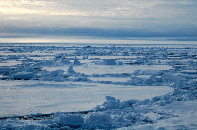
The First Observations of Sea Ice Came From 8th Century Irish Monks in Iceland. Who knew?
Atlas Obscura has more detail: "...
Iceland
was settled more permanently in the 900s, and the people living there
started keeping records of sea ice and icebergs that an Icelandic
geographer later used to reconstruct sea ice records in the area going
back to 1,000 A.D. More systematic records of Arctic sea ice weren’t
collected until about a millennium after Iceland was first settled. In
the 1880s, the Danish Meteorological Institute started drawing up sea
ice charts using reports from the shore and sea, from ships and
scientific expeditions, as the National Snow & Ice Data Center explains,
and by the turn of the century, the institute was regularly publishing a
report on “The State of the Ice in the Arctic Seas” that covered the
whole Arctic..."
Photo credit: "
The frozen sea goes north."
Pink floyd88 a/CC BY-SA 3.0




No comments:
Post a Comment