Damp & Cloudy Weather Continues
Did you know that January is typically our snowiest month of the year? Interestingly, the Twin Cities sees a little more than 1ft. of snow during the month, while December is our 2nd snowiest month which comes in just shy of 1ft.. With that said, the Twin Cities has seen 5.6" of snow, which is nearly 3" below average thus far. We are also running nearly 7" below average snowfall for the season.
"January Thaw" Continues
As we continue to head through the 2nd half of January, mild temperatures continue as well. MN State Climatologist Mark Seeley talks about how the probability of temperatures warming above the freezing mark in January.
"The proverbial "January Thaw" (two or more consecutive days with daily high temperatures greater than freezing) for the Twin Cities has historically about an 80 percent probability of occurrence (about a 91 percent probability since 1980 with a pronounced urban heat island effect). This January it is happening to us with an exclamation mark! We may have up to 10 consecutive days with daily high temperatures above freezing if the forecast through January 26th verifies. In this context it would be the 5th longest such streak in the Twin Cities climate records surpassed only by 18 days in January 1944, 15 days in January 1942, 13 days in January 1919, and 11 days in January 1880 and 1909. (thanks to NOAA's Michelle Margraf and DNR-SCO's Pete Boulay for pointing this out)."
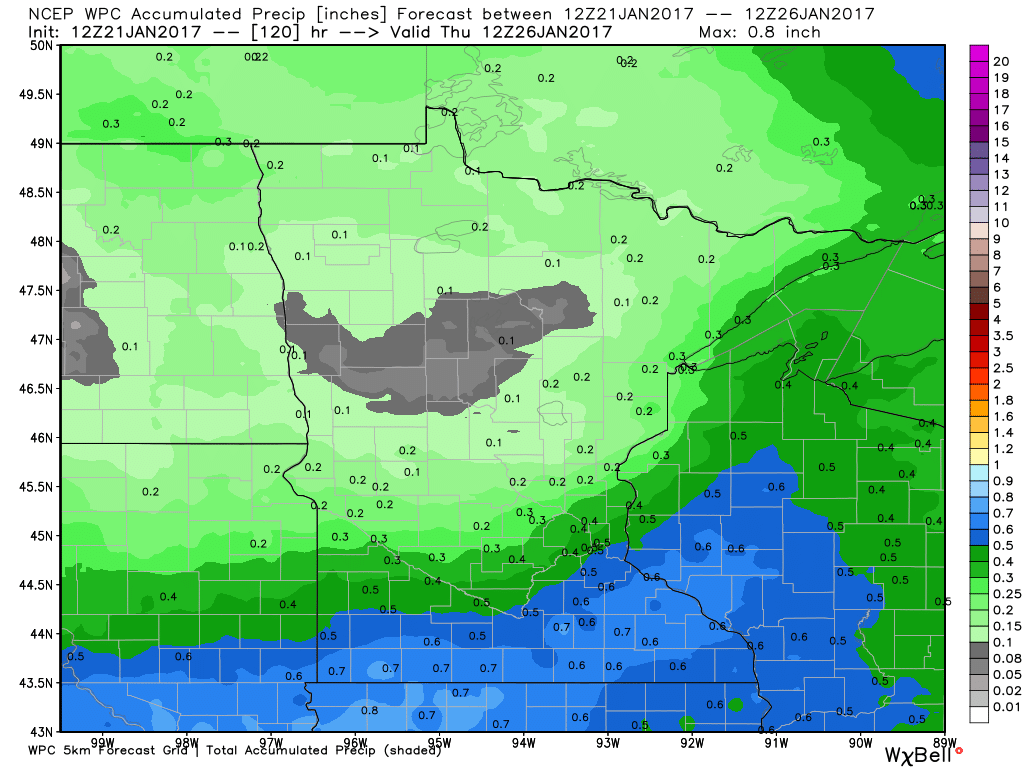
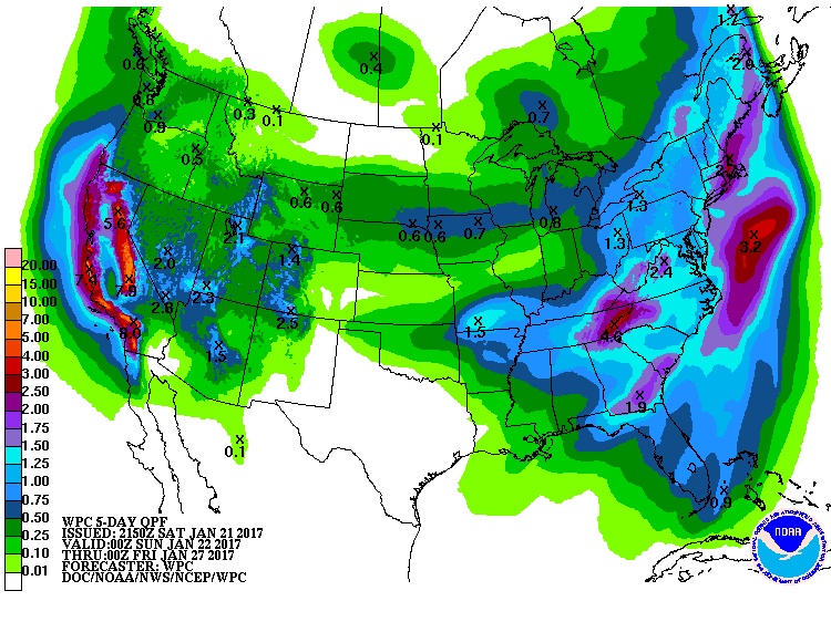
Precipitation Potential
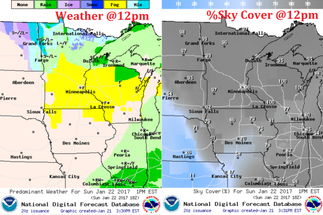
Here's the precipitation potential through Wednesday, which shows fairly impressive precipitation amounts across parts of the state.. Note that temperatures will be warm enough for mostly rain over the weekend. Another system develops Tuesday and Wednesday and temperatures may be cold enough for snow.
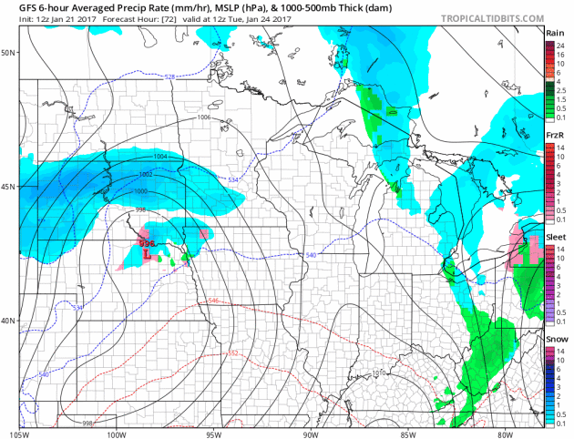
Increasing Snow Chance Early Next Week
A storm system looks to develop early next week with the potential of widespread wet snowfall accumulations. This one will be one to watch as some models suggest a plowable event with travel impacts likely Tuesday - Wednesday. At this point, the heaviest looks to fall across southern MN and near the MN/IA border. Stay tuned for more...
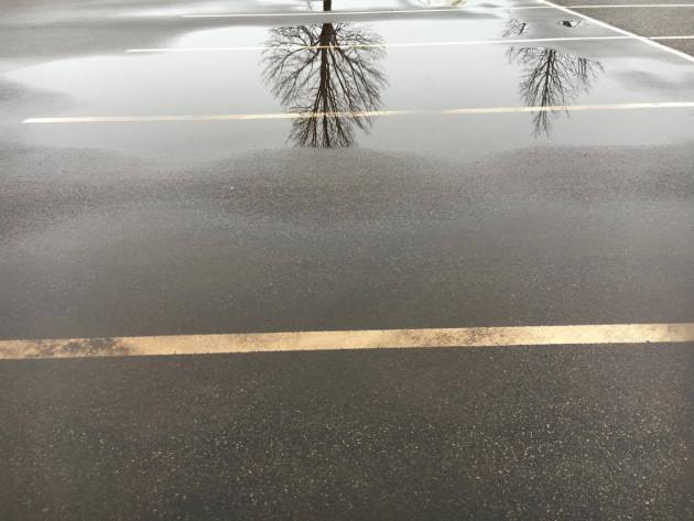
Damp weekend continues. Wet snow by Tuesday
We're stuck in a soggy rut and we can't seem to get out. Thanks to March-like temperatures, scattered rare January rain showers have helped to keep the snow melt on. The result is fog and low clouds mixed with drizzle... Ugh, I feel like a wet dog.
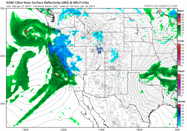
Speaking of wet, the West Coast continues to get slammed with Pacific Moisture. The third and final storm blasts through the region today and tapers tomorrow. Widespread heavy rain, flooding and mountain snow will create travel issues through the early week time frame. Interestingly, the snow water equivalent in the Sierra Nevada Range is already running 150 percent of average!
This next Pacific storm heads our way Tuesday with wet slushy snow accumulations lingering through Wednesday. Daytime highs will cool to below the freezing mark for the first time in more than a week.
According to MN State Climatologist, Mark Seeley, this will be the 5th longest streak with highs in the metro warming above the freezing mark in January. Unreal. I feel like I'm in a Twilight Zone episode.
___________________________________________________________________________
Extended Forecast:
SATURDAY NIGHT: Mild. Cloudy, foggy and drizzly. Winds: NW 5. Low: 35
SUNDAY: Cloudy with stray sprinkles. Winds: NW 5. High: 38.
SUNDAY NIGHT: Cloudy with patchy fog. Winds: WNW 5. Low: 31.
MONDAY: Mostly cloudy and mild. Winds: W 5. High: 40.
TUESDAY: Rain/snow mix. All snow at night. Winds: NNE 5-15. Wake-up: 30. High: 37.
WEDNESDAY: Breezy. Light snow continues. Turning colder. Winds: NNW 10-20. Wake-up: 30. High: 34.
THURSDAY: Brisk wind with scattered flurries. Winds: NW 10-20. Wake-up: 25. High: 29.
FRIDAY: Stray flurry early. Peeks of sun late. Winds: NW 10-15. Wake-up: 20. High: 28.
SATURDAY: Partly sunny. Still warm for January. Winds: NW 5-10. Wake-up: 19. High: 30
_______________________________________________________________________________
_______________________________________________________________________________
This Day in Weather History
January 22nd
January 22nd
1996: A brief cold air funnel touchdown results in roof damage in Washington County.
1936: Summer-like heat continues with 101 at Ada, Beardsley and Moorhead.
_______________________________________________________________________________
_______________________________________________________________________________
Average High/Low for Minneapolis
January 22nd
January 22nd
Average High: 24F (Record: 51F set in 1942)
Average: Low: 7F (Record: -34F set in 1936)
Average: Low: 7F (Record: -34F set in 1936)
*Record Snowfall: 17.2" set in 1982
_______________________________________________________________________________
_______________________________________________________________________________
Sunrise Sunset Times For Minneapolis
January 22nd
January 22nd
Sunrise: 7:42am
Sunset: 5:08pm
Sunset: 5:08pm
*Daylight Gained Since Yesterday: ~2 minutes & 10 seconds
*Daylight Gained Since Winter Solstice (December 21st): ~39 minutes
________________________________________________________________________________
*Daylight Gained Since Winter Solstice (December 21st): ~39 minutes
________________________________________________________________________________
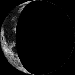
Moon Phase for January 21st at Midnight
2.4 Days After Last Quarter
2.4 Days After Last Quarter
________________________________________________________________________________
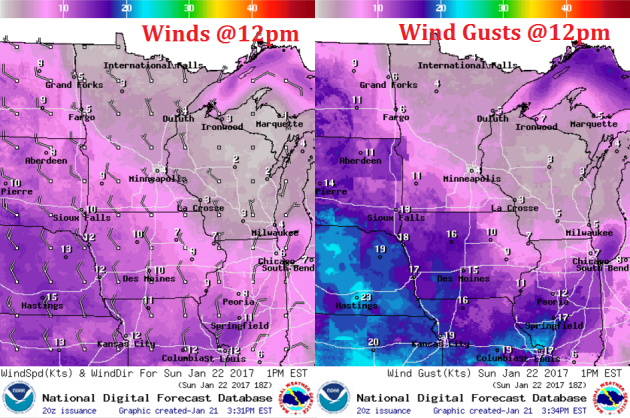
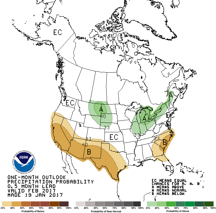
Weather Outlook For Sunday
Sunday will be another very mild day with highs warming into the upper 30s to near 40F. Note that this will still be nearly 15F to 20F years.
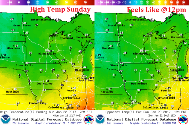
Weather Outlook For Sunday
Winds will start to turn out of the northwest on Sunday, but temperatures will still be nearly the same. Winds don't appear to really pick up in intensity until midweek.
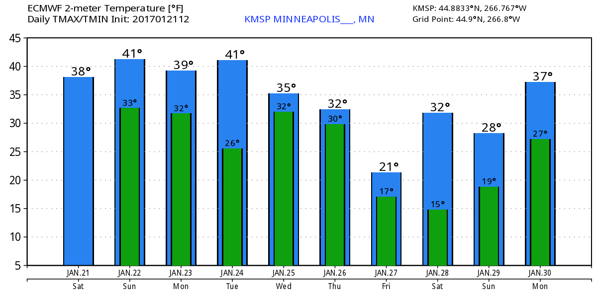
Here's the temperature outlook through January 30th, which shows a VERY mild trend heading through early next week with highs in the 30s and 40s! With several days above freezing, our snow pack will continue to take a big hit... fog concerns will also be an issue with melting snow and added moisture in the lower levels of the atmosphere. By the end of the end of next week, temperatures get a little closer to average, but look to warm to above levels once again at the end of the month.
___________________________________________________________________________________
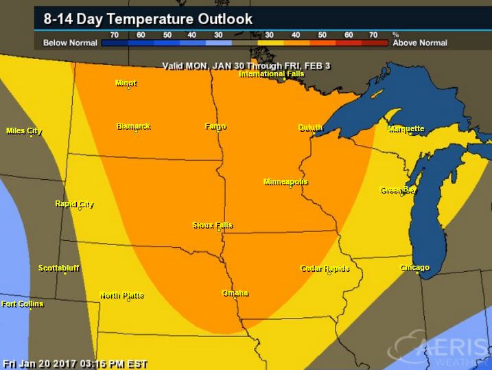
8 to 14 Day Temperature Outlook
According to NOAA's CPC, the 8 to 14 day temperature outlook suggests warmer than average temperatures continuing across much of the Upper Midwest from January 30th to February 3rd. There may be a slight cool down late next week, but the overall trend remains warmer than average.
_________________________________________________________________________________
Temperature Outlook
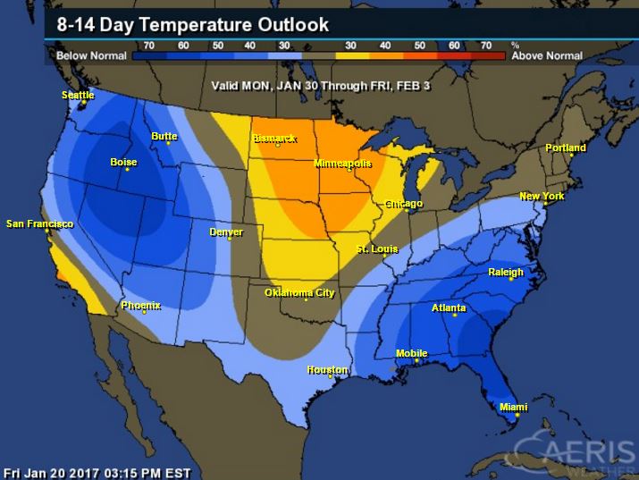
National Temp Outlook
Take a look at the temperature anomaly through Friday, January 27th. Note that the Eastern half of the country looks to stay warmer than average through much of that time period, but colder than average temps begin moving into the Western & Central U.S. by the middle/end of next week.
.gif) ________________________________________________________________________________
________________________________________________________________________________
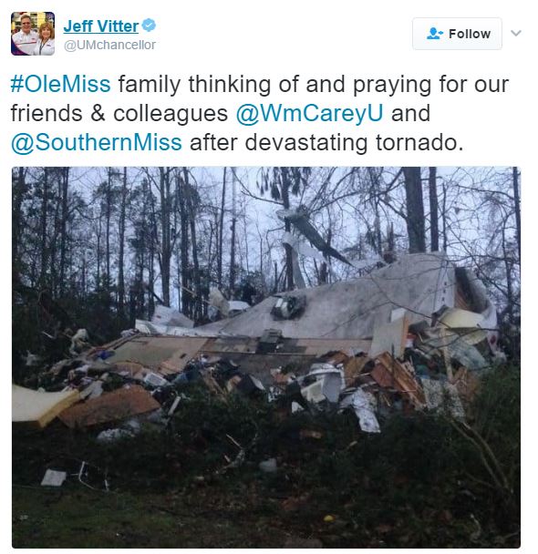
Devastating Storms in the South
It has been a very active weekend thus far in the Deep South. Take a look at some of the tornado damage across parts of Mississippi. While there have been nearly 2 to 3 dozen tornadoes already, one in particular injured 4 in Toxey, AL.

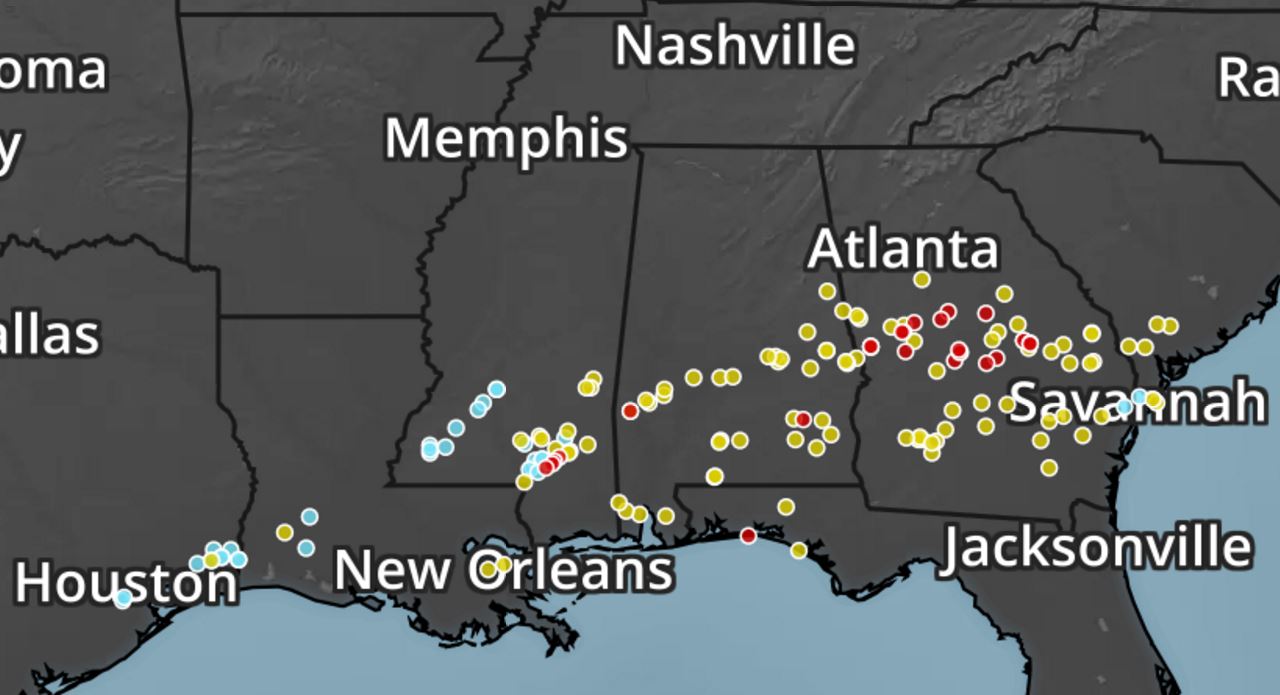
 Severe Storm Reports This Weekend
Here's a look at all the storm reports through PM Saturday, which suggested widespread hail, damaging wind and even tornado reports from near Houston, TX to Georgia and southern South Carolina.
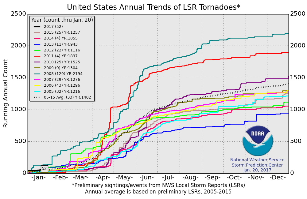
2017 Tornado Count
According to NOAA's SPC, there have been 52 PRELIMINARY tornado reports so far this year (through January 20th). Note that this is more than the short-term (2005-2015) average of 33 through January 20th.
________________________________________________________________________________
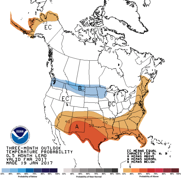
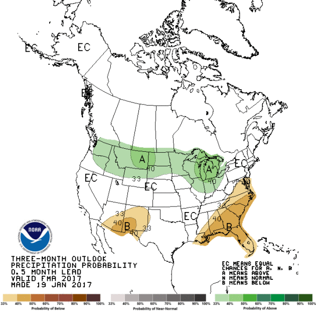
February - March - April Outlook
NOAA's CPC released their February - March - April outlook, which shows that much of the Southern U.S. and parts of Alaska will be warmer than average, while the northern tier of the nation will be colder than average. The precipitation outlook suggests wetter than average conditions will be found across the northern tier of the nation, while drier than average weather will be found across parts of the Southern U.S..
Devastating Storms in the South
It has been a very active weekend thus far in the Deep South. Take a look at some of the tornado damage across parts of Mississippi. While there have been nearly 2 to 3 dozen tornadoes already, one in particular injured 4 in Toxey, AL.
Here's a look at all the storm reports through PM Saturday, which suggested widespread hail, damaging wind and even tornado reports from near Houston, TX to Georgia and southern South Carolina.
2017 Tornado Count
According to NOAA's SPC, there have been 52 PRELIMINARY tornado reports so far this year (through January 20th). Note that this is more than the short-term (2005-2015) average of 33 through January 20th.
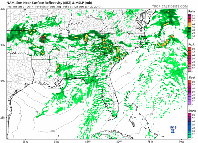
Thundery Outlook In the Southeast Through The Weekend
Heres' the simulated radar from Sunday to Monday morning, which shows ongoing showers and storms across parts the Southeastern U.S.. Widely scattered severe weather including large hail, damaging winds and even tornadoes will be possible through Sunday evening.
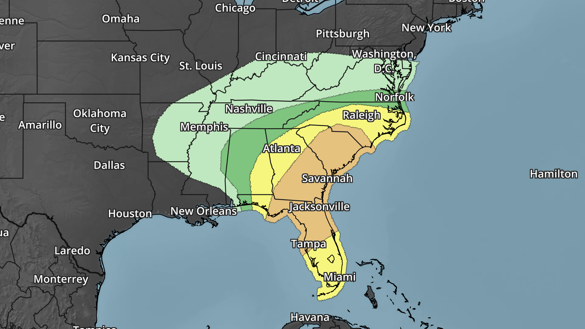
Severe Weather Concerns Ahead
Here's the severe weather outlook for Sunday, which shows an elevated risk of large hail, damaging winds and even the potential for tornadoes from Florida to the Carolinas.
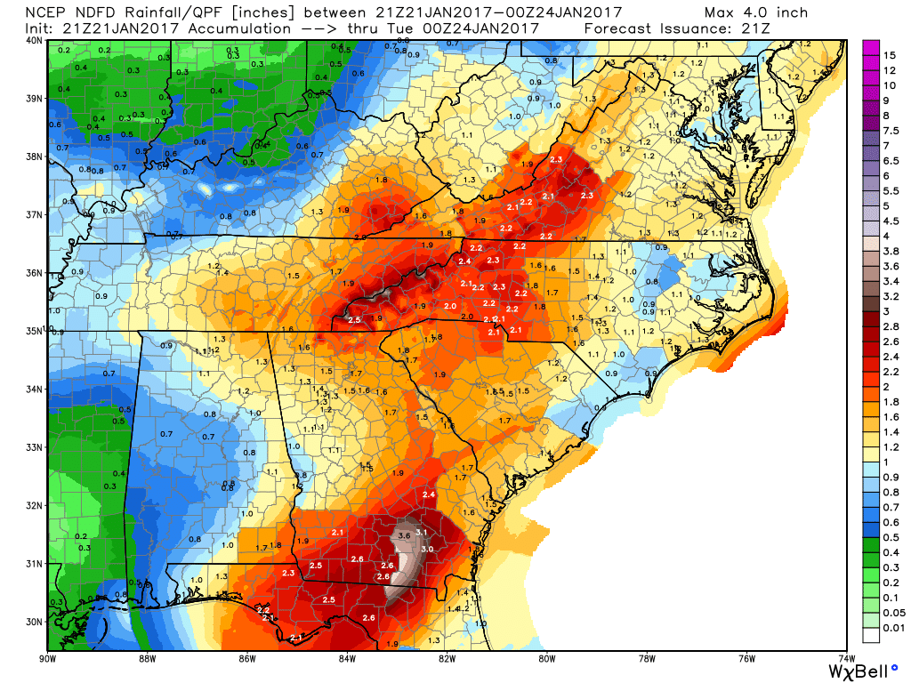
Heavy Rain Threat Ahead
Scattered showers and storms will continue across the Southeastern U.S. through the early next week, which will help to bring widespread 2" to 3"+ rainfall tallies to the region, including the threat of flooding.
 _____________________________________________________________________________
Snowfall has been most impressive across parts of the Western U.S. with some spots seeing feet of snow over the last several weeks. Take a look at this picture from Yosemite National Park where nearly 2ft of snow has fallen in the past week. Here's an excerpt from Yosemite Conservancy, which says that the Central Sierra snow water equivalent is at 150% of normal for this time of year.
"The latest update from Yosemite's winter rangers! More than 2 feet of snow fell in the high country over the past week. As of yesterday, Central Sierra snow water equivalent is at 150% of normal for this time of year (for the latest snowpack info, check out the CA Data Exchange Center: cdec.water.ca.gov/snow/current/snow/)."
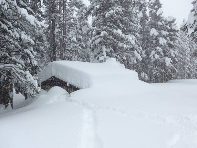
Tuolumne Meadows Ski Hut - January 12, 2017.
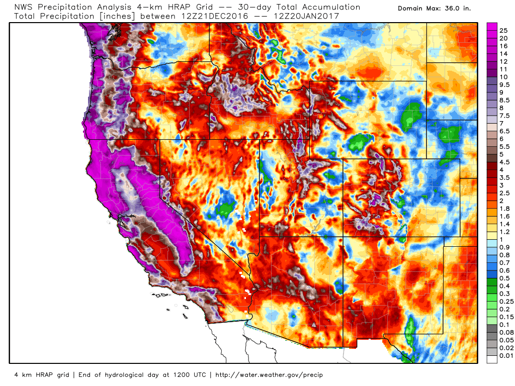
Take a look at how impressive the 30 day precipitation tallies are across the West Coast. Note the purple colors that indicate 12" of liquid! Some spots have quite a bit more than that and there's more precipitation on the way!
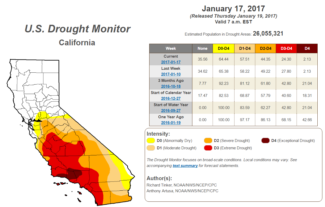
Improving California Drought
According to the U.S. Drought Monitor, the California drought continues to improve. Note that from last week to this week, there was more improvement in the Extreme and Severe drought. WIth the additional moisture late last week and through the next several days, we should continue to see even more improvement!
Atmospheric Rivers Continue...
The last several days have featured multiple rounds of heavy moisture across the Western U.S. thanks to rivers of moisture from the Pacific. The last river of moisture pushes through the region late weekend and into early next week with widespread heavy rainfall and heavy mountain snow.
Last Wave of Pacific Moisture
Several rounds of heavy precipitation have blasted the West Coast and we're not quite done yet. Another surge of heavy precipitation will push through the region through the rest of the weekend and into early next week with significant rainfall, flooding and heavy mountain snow.
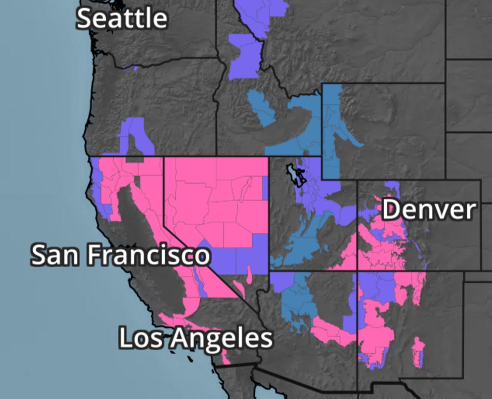
Western Winter Weather Concerns
A number of winter weather headlines continue across the Western U.S. over the next few days with 1ft. to 2ft. possible in some of the most extreme cases. Also note that the mountains near Los Angeles and Arizona are under winter storm warnings, where up to 1ft of snowfall will be possible through the weekend.
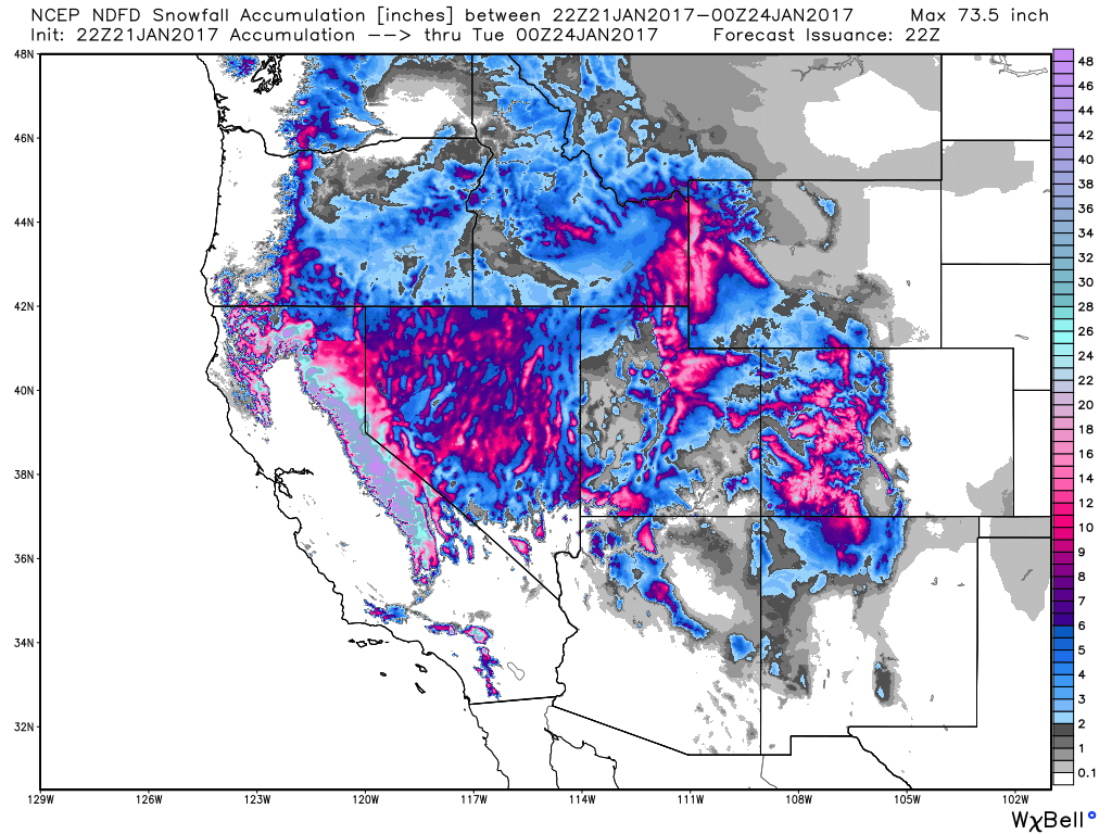
Snowfall Potential
Here's the snowfall potential through early next week, which shows widespread heavy mountain snow. Another 1ft to 2ft.+ can't be ruled out across the Sierra Nevada Range, while heavy snow may also be possible in the mountains across southern California and into Arizona.
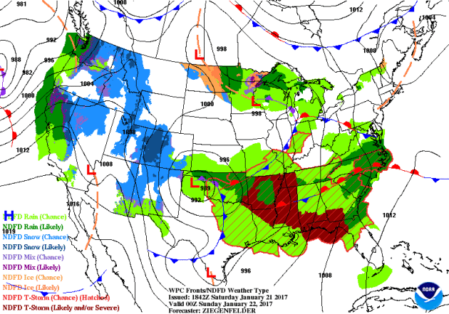
Here's the national weather outlook through early next week, which shows scattered storms and locally heavy rainfall continuing and redeveloping across the Southeastern U.S.. Note that some of the storms late weekend could still be severe. The Western U.S. will also be inundated with widespread heavy precipitation through the early week time frame. Heavy rain, flooding and heavy mountain snow will be possible as the last round of Pacific moisture "Atmospheric River" moves through late weekend and early next week.
 5 Day Precipitation Forecast
Here's the snowfall potential through early next week, which shows widespread heavy mountain snow. Another 1ft to 2ft.+ can't be ruled out across the Sierra Nevada Range, while heavy snow may also be possible in the mountains across southern California and into Arizona.
National Weather Outlook
According to NOAA's PC, the 5 day precipitation forecast suggests widespread 2" to 4"+ rainfall amounts across the Eastern U.S.. Also note the heavy moisture continuing in the West U.S., especially along the coast of California and the Sierra Nevada Range. This will be great news for more drought denting, but in other cases, this moisture will cause more flood issues!
_________________________________________________________________________________
"All References to Climate Change Have Been Deleted From the White House Website"
"At 11:59 am eastern, the official White House website had a lengthy information page about the threat of climate change and the steps the federal government had taken to fight it. At noon, at the instant Donald Trump took office, the page was gone, as well as any mention of climate change or global warming. It’s customary for www.whitehouse.gov to flip over to the new administration exactly at noon, but the only mention of climate on President Trump’s new website is under his “America First Energy Plan” page, in which he vows to destroy President Obama’s Climate Action Plan, which is a government-wide plan to reduce carbon emissions and address climate change. To reiterate: It is normal that the site is completely new; it is notable that climate change is not mentioned on any one of Trump's new pages."

_____________________________________________________________________________
"Climate change threatens Great Lakes forest health, researchers say"
"LANSING — Great Lakes forests will get warmer and suffer more frequent short-term droughts, scientists say. “We know climate change is going to really stress these systems in ways they haven’t been stressed in the last several thousand years,” said Stephen Handler, a Houghton-based climate change specialist with the U.S. Forest Service. How trees will respond to such different growing conditions is unknown. But experts say they can’t wait to find out. “You don’t wait until the car has already gone over the cliff,” Handler said. “You hit the brakes when you can. You steer and find a better way around the cliff.” Handler is among the researchers who are taking the wheel. They’re already figuring out what forest managers can do to mitigate potentially devastating impacts."
(Image courtesty: NOAA)
__________________________________________________________________________________
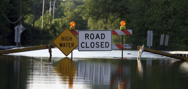
"It's not in your head: The weather is weirder, and climate change is the reason why"
"Extreme flooding events are becoming more common in the United States. If it seems like you’re reading about devastating floods, droughts, and storms way more often than you used to, it’s because these extreme events are actually happening more frequently. But this should come as no surprise. Climate scientists predicted that this would happen as more greenhouse gases accumulated in Earth’s atmosphere. Certain extreme weather events have long been anticipated, just like the pronounced warming in the Arctic."
(Image Credit: NOAA)
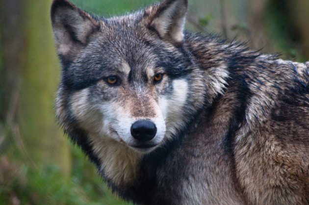
"NPS May Send Pack Of Wolves To Isle Royale"
:Down to just two wolves in the past five years, a new plan hopes to revitalize the presence of alpha carnivores in the dynamic island habitat off the northern coast of Minnesota.A National Park Service plan hopes to introduce up to 30 wolves to Isle Royale in Lake Superior. The topic is open for public comment until March 15."
(Image Credit: GearJunkie via Flikr/Barnaby_S)
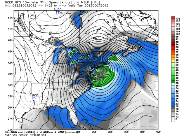
"NOAA and the new administration: Will Trump make America’s weather model great again?"
America’s primary computer model for predicting the weather is not as accurate as the Europeans’. Many meteorologists and lawmakers lament that the United States has fallen behind Europe in global weather modeling. Could the incoming Trump administration, which has placed a real emphasis on U.S. competitiveness, try to put the United States back on top in the world of weather modeling? What might be some of President-elect Donald Trump’s other key priorities within the National Oceanic and Atmospheric Administration?
{GFS model simulation of Superstorm Sandy in 2012. (WeatherBell.com)}
 _____________________________________________________________________
"Climate Change May Reduce Some U.S. Grain Harvests by Half"
*Scientists developed computer model to show effect on crops
*Corn, soybean yields may lose 40%-50% by end of the century
*Corn, soybean yields may lose 40%-50% by end of the century
Some of the most important U.S. crops, from wheat to soybeans, are at risk of substantial damage from climate change. Higher temperatures may cut the wheat harvest by 20 percent by the end of the century without efficient carbon reductions, according to a study by researchers including the Potsdam Institute for Climate Impact Research and the University of Chicago. Yield reduction could reach 40 percent for soybeans and almost 50 percent for corn, relative to non-elevated temperatures, the group said in a report released Thursday. "The effects go far beyond the U.S., one of the largest crop exporters," the researchers said. "World market crop prices might increase, which is an issue for food security in poor countries."
See more from Bloomberg HERE:
(Image credit: Bloomberg)
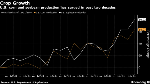
See more from Bloomberg HERE:
(Image credit: Bloomberg)
___________________________________________________________________________________
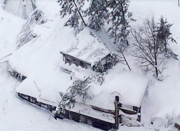
"Avalanches are becoming more common, thanks to climate change, researchers say"
"An avalanche buried an Italian resort on Wednesday, leaving at least 30 people trapped inside and scores likely dead. Officials link the immediate cause to earthquakes in central Italy. But scientists say there's another reason that snow slides are becoming more common: climate change. Avalanches are caused by a combination of geological factors (like the incline of a mountain or natural events like earthquakes), weather and the structure of the snow. Warmer weather can weaken a mountain's snow pack and make it more difficult for the layers of snow to stick together. Mix in another element, like particularly gusty wind or trembling earth, and you've got a mountain primed for avalanche."
{A hotel in central Italy was hit by an avalanche, leaving 30 people likely buried under the snow. (Reuters)}
 _______________________________________________________________________________
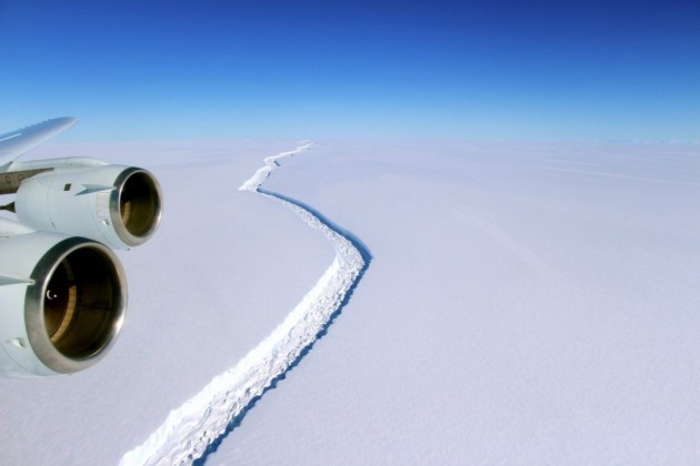
"The huge crack in this Antarctic ice shelf just grew by another 6 miles"
"A crack more than 100 miles long in one of Antarctica’s largest ice shelves grew another 6 miles in a little more than two weeks this month, British scientists reported Thursday. That’s on top of an 11-mile growth that occurred in the second two weeks of December — representing a 17-mile total advance in not much more than a month. The extension of the rift in the Larsen C ice shelf ran roughly parallel to the ocean-terminating front of the floating ice shelf, and so, did not bring it any closer to breaking off a large piece — 12 miles of ice still connect the emerging ice island to the larger shelf. But the parallel growth may ensure that the iceberg, when it does break off, will be somewhat larger."
{A Nov. 10 photo made available by NASA shows a view of a massive rift in the Antarctic Peninsula’s Larsen C ice shelf, Antarctica. (John Sonntag/NASA via European Pressphoto Agency)}
Thanks for checking in and don't forget to follow me on Twitter @TNelsonWX

No comments:
Post a Comment