+ 1.5 F. Metro temperatures in January are running 1.5 F. above average, to date.
40 F. high in the Twin Cities Sunday, average for March 13.
24 F. average high on January 22.
25 F. high on January 22, 2016.
January 23, 1963: A record low of -31 is set at the Minneapolis-St. Paul International Airport.
4th of 5th Longest January Thaw on Record for MSP
"March-uary"?
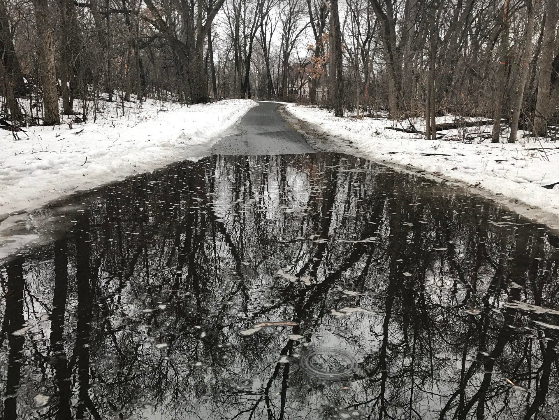
I seriously overslept. I went to bed in mid-January - woke up in late March, complete with pond-size puddles and a few dreary piles of dirty snow. March-like mud and mush in my sloppy yard.
Most years we enjoy a January Thaw, but this one has been super-sized. We may go 11 days in a row with highs above freezing; the 4th longest stretch since 1872, according to Dr. Mark Seeley.
To say it's been an odd winter would be an understatement: we flip-flop between subzero outbreaks and freakish, midwinter rains. Where's the snow?
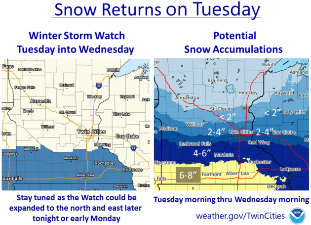
The next system tracks from Denver to Milwaukee, brushing us with a few inches of slushy snow late Tuesday into Wednesday morning. Freeways may stay wet and slushy, but a little ice may return later in the week as temperatures finally drop into the 20s. No bitter blasts brewing until (maybe) the second week of February.
Our weather is a 2 on the Whine-O-Meter. Killer tornadoes hit the south over the weekend; a parade of massive storms pummeling California with flooding and mudslides. We have precious little to complain about.
It looks like Seattle outside my window. Yes, January has mellowed - but don't let your guard down just yet.
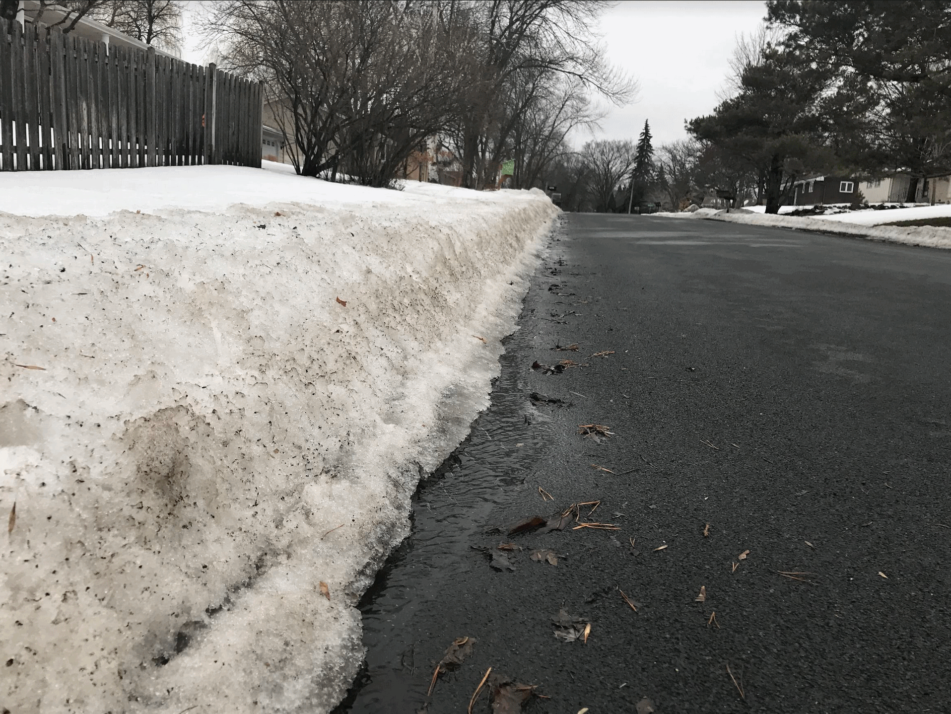
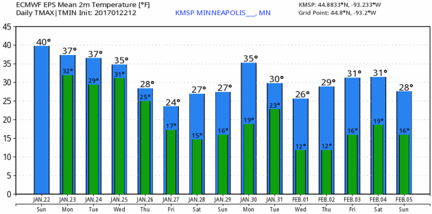
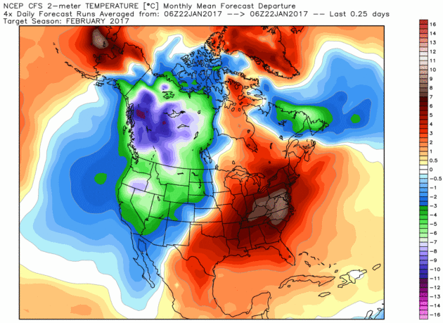
Super-Sized January Thaw. Here's more perspective on this current of temperatures above 32F, courtesy of Dr. Mark Seeley and Minnesota WeatherTalk: "...The proverbial "January Thaw" (two or more consecutive days with daily high temperatures greater than freezing) for the Twin Cities has historically about an 80 percent probability of occurrence (about a 91 percent probability since 1980 with a pronounced urban heat island effect). This January it is happening to us with an exclamation mark! We may have up to 10 consecutive days with daily high temperatures above freezing if the forecast through January 26th verifies. In this context it would be the 5th longest such streak in the Twin Cities climate records surpassed only by 18 days in January 1944, 15 days in January 1942, 13 days in January 1919, and 11 days in January 1880 and 1909. (thanks to NOAA's Michelle Margraf and DNR-SCO's Pete Boulay for pointing this out). Over 50 Minnesota climate stations have already reported daytime highs in the 40s F this week, including 48°F at both Grand Rapids and Forest Lake on the 18th..."
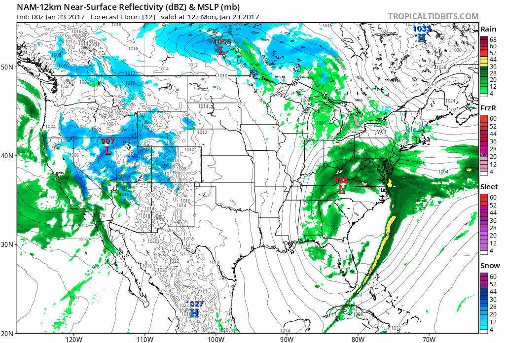
Rainy Nor'easter - More Storms for California. The 84-hour 12 KM NAM shows the southeast drying out, after a weekend of severe storms and large, April-like tornadoes. A powerful storm pushes up the east coast with a cold rain for major cities from Washington D.C. to New York and Boston; ice and heavy wet snow well inland. Meanwhile California sees more rain (not as heavy or violent as Sunday's storm) and a storm tracking from near Denver to Milwaukee will push a few inches of wet, slushy snow across the Midwest and Upper Mississippi Valley Tuesday into Wednesday. Loop: Tropicaltidbits.com.
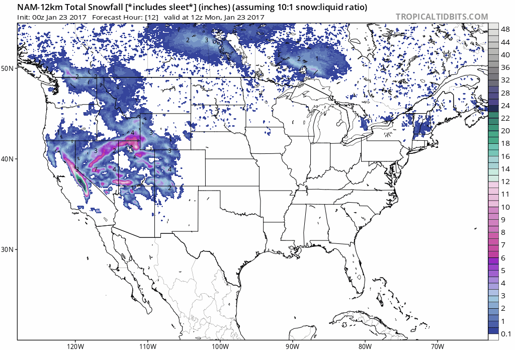
84-Hour Snowfall Potential. It's a model, not reality, but looking at NOAA's NAM guidance from the 00z run you get a pretty good idea who may see plowable amounts of snow into Thursday morning: Poconos into much of interior New England - South Dakota into central and southern Minnesota and Wisconsin and the heavy snow continues to pile up across the Rockies. What a winter for skiers out west, about as good as it gets.
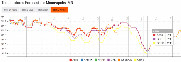
Brief Cold Correction Middle of Next Week?
NOAA models, specifically the GFS model ensembles, show single digit
wake-up temperatures a week from Wednesday, followed by a fairly speedy
recovery. With a higher sun angle in February it gets increasingly
difficult for (sustained) subzero days and nights. Not impossible, but
the negative numbers usually don't last as long as they do in January.
Graphic: Aeris Enterprise.
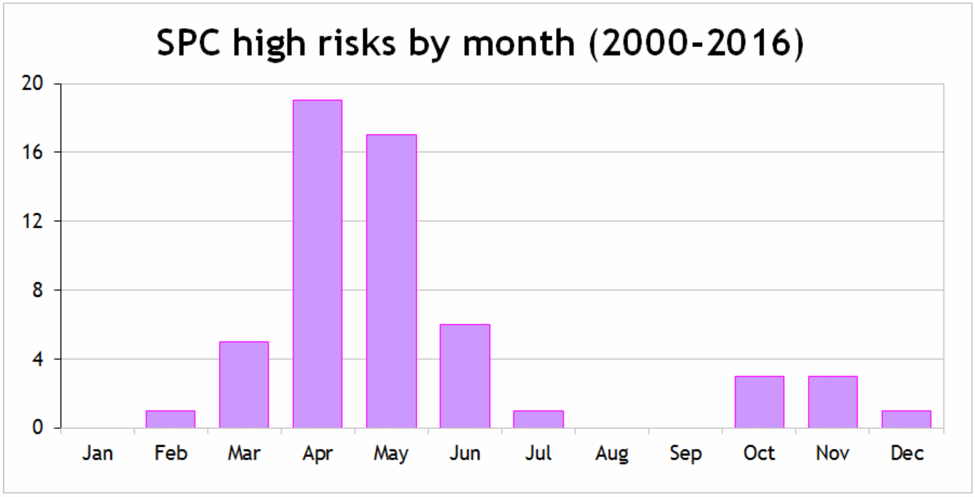
Putting High Risk Severe Outbreaks Into Perspective. An average of 51 to 62 tornadoes? I learned something at ustornadoes.com; Ian Livingston takes a look at the average number of tornadoes during high-risk severe days since 2000, as defined by NOAA SPC: "Looking at the averages from these events, the numbers are fairly stark. Since any small sample that includes April 27, 2011 is going to be skewed more than normal, I’ll share the figures with and without it included (these are 15 and 14 event averages respectively):
- With 4/27/2011: Average high risk has 62 tornadoes, 16 of which are strong (EF2+), and two are violent (EF4-5). Four killer tornadoes occur on average, causing 31 deaths. The deadliest averages 10 killed. The longest track tornado averages 58.0 miles.
- Without 4/27/2011: Average high risk has 51 tornadoes, 13 of which are strong, and one is violent. Two killer tornadoes occur on average, causing 11 deaths. The deadliest averages six killed. The longest track tornado averages 52.7 miles..."
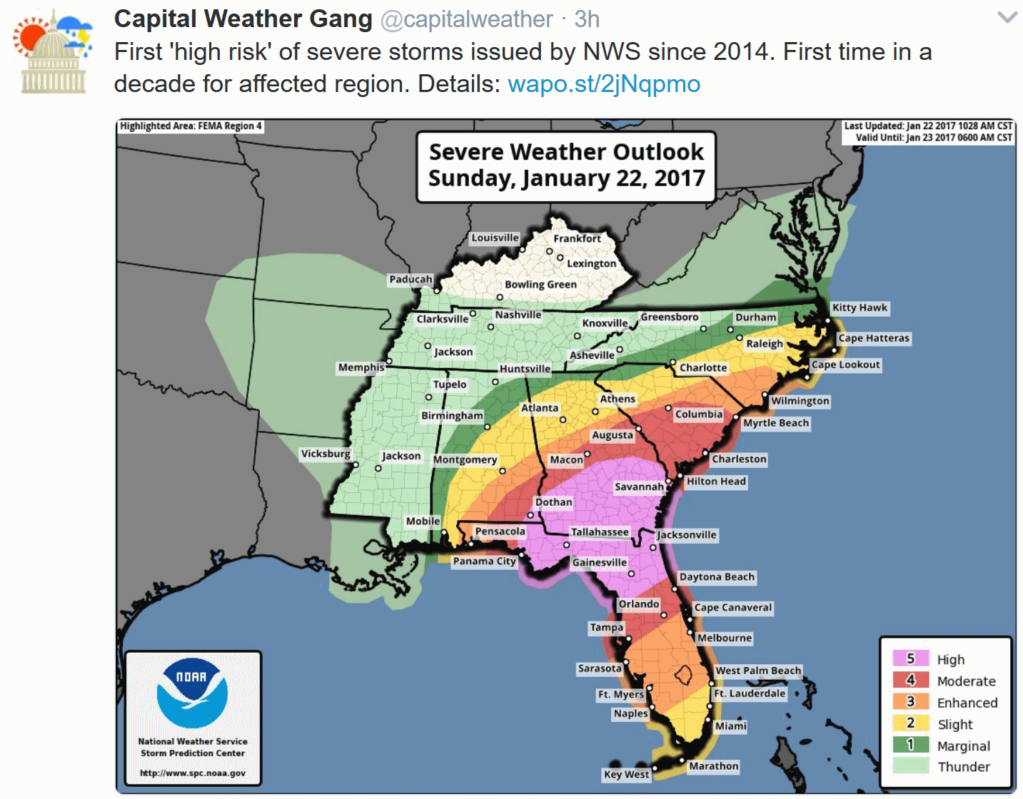
More April than January. The forecast of a major tornado outbreak for the southeast on Sunday verified. There was plenty of advance warning from NOAA, trusted sources on social media and both local and national media. Here's an excerpt of a corporate briefing we sent to our clients yesterday morning:
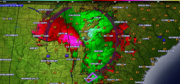
- A significant tornado outbreak, with multiple strong, long-tracked tornadoes is likely across northern Florida and southern Georgia today.
- A HIGH RISK of severe weather is in place for parts of Alabama, Georgia and Florida due to this threat. The cities at highest threat include Jacksonville, Tallahassee, Gainesville (FL) as well as Savannah and Albany (GA).
- However, the threat for tornadoes, hail and wind extend from southern Alabama into the Carolinas and across the entire Florida panhandle into the evening hours.


Map credit: AerisWeather.

The other big weather story: More heavy rains pushing into California:


Summary. Significant severe weather - especially strong, long-tracked tornadoes - is expected today across portions of the Southeast, including Jacksonville, Tallahassee, Gainesville (FL) as well as Savannah and Albany (GA). This is where an uncommon HIGH RISK of severe weather is in place. Stay alert for potentially life-threatening conditions throughout the day today, and be ready to take action. Out west, heavy rain continues across California today, and another 1-4"+ of rain will continue to lead to flood issues into the early week.
D.J. Kayser, Meteorologist, AerisWeather
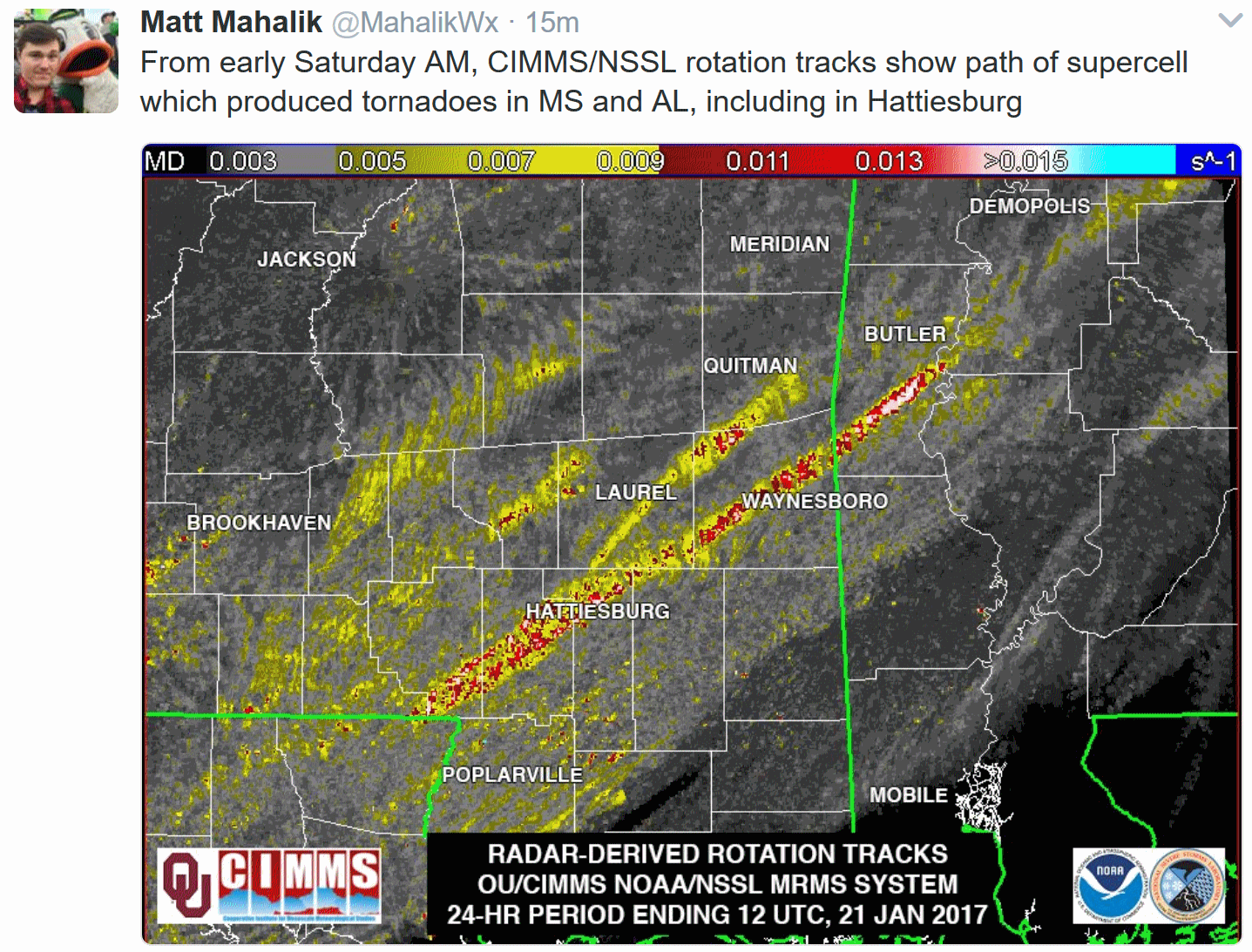
Image credit: "A true color image of 2016 Hurricane Matthew making landfall over the U.S. eastern coast. True color imagers have historically been a part of many polar-orbiting satellites, unlike their geostationary cousins." Image credit: SSEC.
Click here for some of the first test imagery from GOES-16 today, courtesy of NOAA NESDIS.
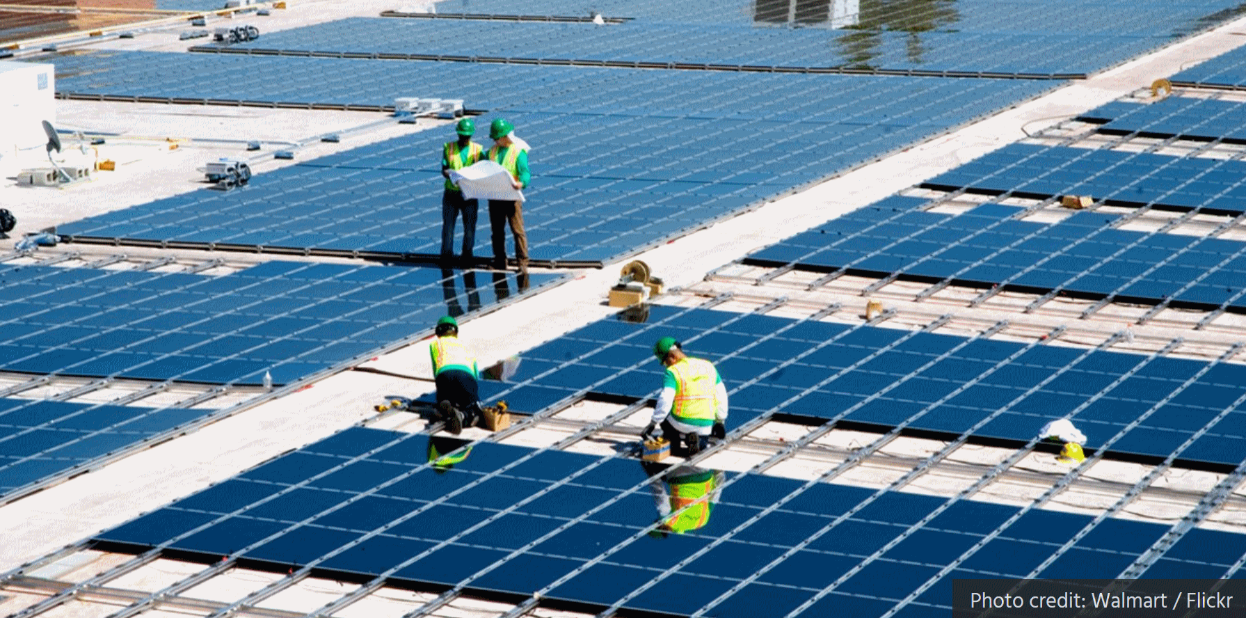
Solar Employs More Workers Than Coal, Natural Gas and Oil Combined. Here's a clip from EcoWatch: "U.S. solar employs more workers than any other energy industry, including coal, oil and natural gas combined, according to the U.S. Department of Energy's second annual U.S. Energy and Employment Report. 6.4 million Americans now work in the traditional energy and the energy efficiency sector, which added more than 300,000 net new jobs in 2016, or 14 percent of the nation's job growth..."
Photo credit: Walmart, Flickr.

Photo credit: Slate, which is skeptical about the whole flying car thing.

Medium, And The Reason You Can't Stand the News Anymore.
Turns out the Internet has been anything but a unifying force, for our
nation or those engaged in explaining the news of the day, and yet we
all seem to live in our curated, "safe" information bubbles every day.
Here's an excerpt of a thoughtful piece at Medium: "...Companies from Medium to The Washington Post to Mashable to Buzzfeed all eventually run into the same unthinkable truth: The methods used to fund modern journalism simultaneously undermine trust in the news outlets.
Editors, writers, and executives at today’s news outlets are all in a
no-win situation where they are forced to contribute to the causes of
their own demise to survive. In any other business, companies would try,
fail, and another would take its place. This is good and needed. But
for news, the failures are happening at a glacial pace and bad actors
are profiting as the trustworthiness of our news outlets are breaking
down in slow motion. The result is the worst kind of feedback loop,
where well-meaning people try to “fix” the news. But instead, those
methods erode trust in all news outlets leading to a total breakdown in
discourse..."
Journalism That Stands Apart. Here's a Report of the 2020 Group at The New York Times.
The Highest Places in America. Just in case you were wondering Atlas Obscura has details: "...Each
of the 50 states, as well as D.C., has its own such geographic marker,
sought out by a particular niche of explorers known as highpointers,
which Atlas Obscura writer Thomas Harper described in his account of this elevated subculture.
Scaling each of the state high points means spanning the whole spectrum
of the country’s diverse landscape. These markers can be found
in deserts and dense forests, from the remote wilderness to urban areas
and everything in between. Here are 51 places to get high in the United
States..."


TODAY: Clouds and fog, 9th consecutive day of the January Thaw. Winds: W 5-10. High: 37
MONDAY NIGHT: Damp and overcast. Low: 30
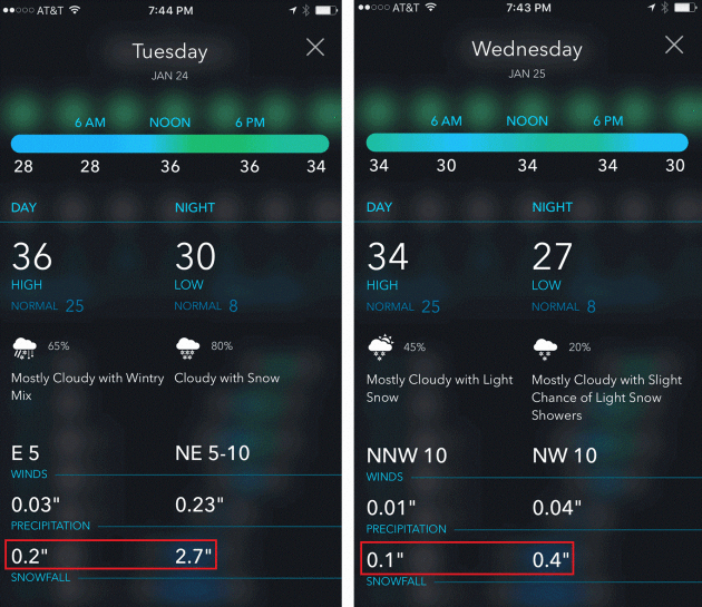
TUESDAY: Wet snow develops, possibly mixed with rain. Heavier snow Tuesday night. Winds: E 8-13. High: 37
WEDNESDAY: Total of 2-4" of slushy snow? Wet snow tapers to flurries. Winds: NW 10-20. Wake-up: 31. High: 34
THURSDAY: Mostly cloudy, cooler breeze. Winds: NW 10-15. Wake-up: 25. High: 30
FRIDAY: More clouds than sun, pretty quiet. Winds: W 10-15. Wake-up: 19. High: 29
SATURDAY: Peeks of sun, still above average. Winds: NW 8-13. Wake-up: 18. High: 31
SUNDAY: More sun, turning milder again. Winds: W 7-12. Wake-up: 19. High: 34
Climate Stories...
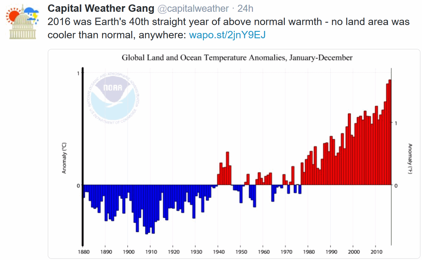
Earth Sets a Temperature Record for the Third Straight Year. Just in case you missed Justin Gillis's report at the New York Times: "...In 2015 and 2016, the planetary warming was intensified by the weather pattern known as El Niño, in which the Pacific Ocean released a huge burst of energy and water vapor into the atmosphere. But the bigger factor in setting the records was the long-term trend of rising temperatures, which scientists say is being driven by increasing levels of carbon dioxide and other greenhouse gases. “A single warm year is something of a curiosity,” said Deke Arndt, chief of global climate monitoring for the National Oceanic and Atmospheric Administration. “It’s really the trend, and the fact that we’re punching at the ceiling every year now, that is the real indicator that we’re undergoing big changes...”
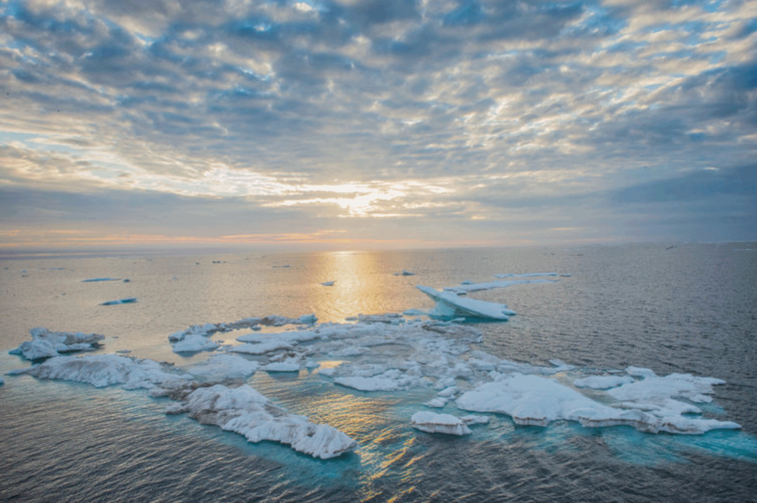
Photo credit: "Ice in the Arctic Ocean’s Chukchi Sea region. “What’s going on in the Arctic is really very impressive; this year was ridiculously off the chart,” said Gavin A. Schmidt, the head of NASA’s Goddard Institute for Space Studies." Credit: Esther Horvath.


Fearing White House Purse of Climate Science, Scientists Frantically Copying Data. Here's an excerpt from a story at Forbes: "...After the election in November, a bipartisan group of defense experts and former military leaders urged the President-Elect, through the Trump Transition Team, to consider climate change as a grave threat to our national security. In 2014, the Military Advisory Board came out with a report, called National Security and the Accelerating Risks of Climate Change, that discusses what the military sees as the threats of climate change and the actions to be taken to mitigate them: “The potential security ramifications of global climate change should be serving as catalysts for cooperation and change. Instead, climate change impacts are already accelerating instability in vulnerable areas of the world and are serving as catalysts for conflict...”
Photo credit: "A U.S. Navy Carrier Strike Group in the South China Sea. The U.S. military is worried that climate change is a significant threat multiplier for future conflicts. And the Navy may bear the brunt of these effects. Unfortunately, the new Administration is purging this type of thinking from all branches of government, including our military." Source: U.S. Navy photo by Mass Communication Specialist 1st Class David Mercil/Released.
No comments:
Post a Comment