14 F. high temperature yesterday in the Twin Cities.
27 F. average high on February 8.
17 F. high on February 8, 2016.
February 9, 1899: The mercury plummets to -59 at Leech Lake Dam.
Out on a Muddy Limb: Spring Comes Early This Year
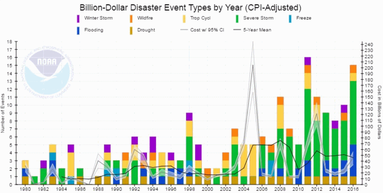
If you don't like the weather in New England now, just wait a few minutes" said Mark Twain. Looking at weather data - extremes appear to be trending even more extreme over time.
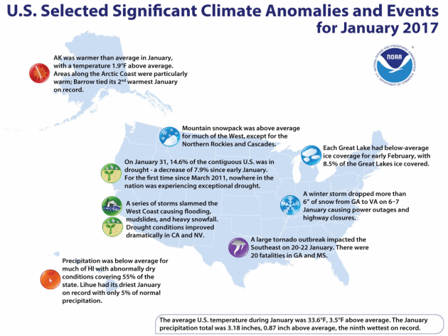
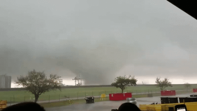
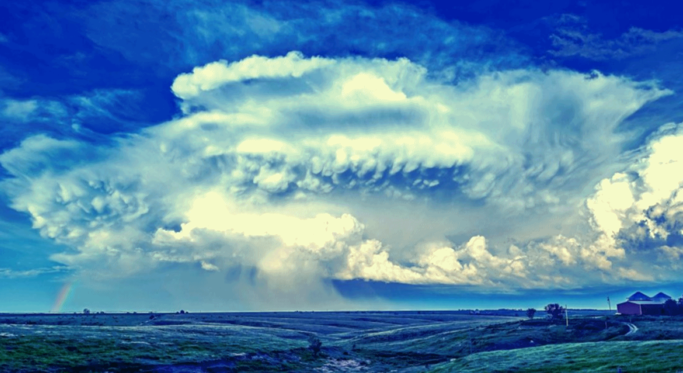
Exhibit A: this winter. Low 60s in New York City yesterday - today a foot of snow. EF-3 tornadoes roaring through New Orleans. As much as 15 to 20 FEET of snow for the mountains of California. Not to mention at least 5 separate thousand-year flash floods in 2016. Maybe weather has always been this crazy, but it does make you stop and wonder.
It was so cold yesterday I saw a teenager with his pants pulled all the way up. Remarkable. Expect brisk sunshine and teens again today, but we enjoy our own weather-whiplash Friday as temperatures surge into the 40s. 50F is not out of the question, which is perfectly normal for April Fool's Day.
Meteorological Winter officially comes to an end in 19 days but you could make a case that winter is already over. We'll see more cold frontal passages and spurts of slush into March, but nasty wind chills?
Breathe deep to feel today's cold tickle - spring arrives Friday.
Graphic credit above: NOAA NCDC.
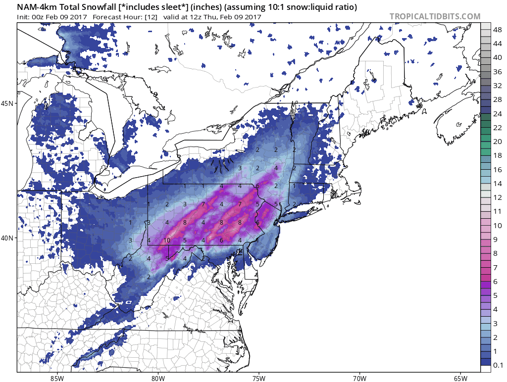
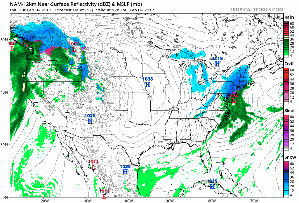
Snow-Burst. This storm is a "bomb", slang for a storm that is strengthening explosively. The fast forward motion will prevent even heavier amounts, but a swath of 12" is likely from the northern suburbs of New York City to Hartford, Providence and Cape Cod. Boston should pick up at least 10" of snow. Near-blizzard conditions are possible from Long Island and the immediate coast of Connecticut to Cape Cod. Source: 4 KM NAM from NOAA and Tropicaltidbits.com
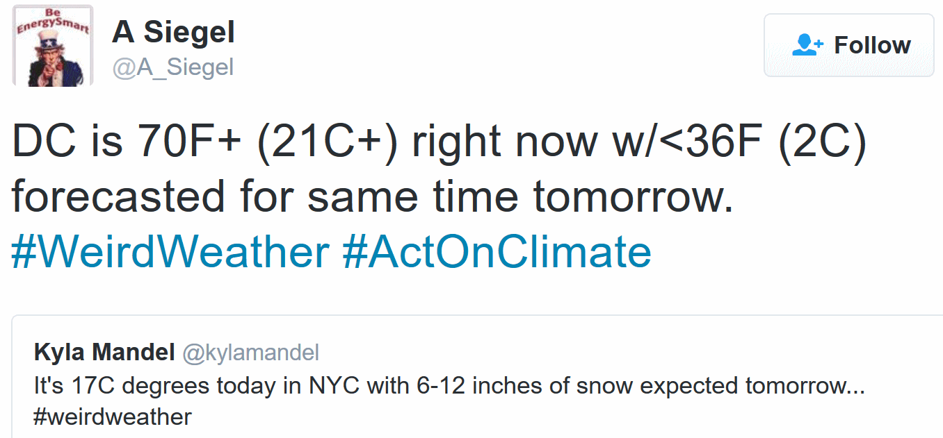
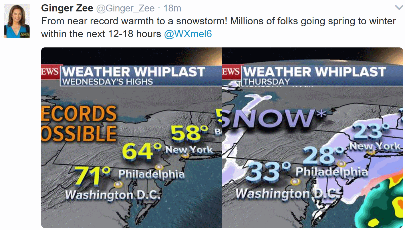
Serious Weather Whiplash. From low 60s on Wednesday to nearly a foot of snow and near-blizzard conditions 12 hours later in New York City? That's about as extreme as it ever gets.
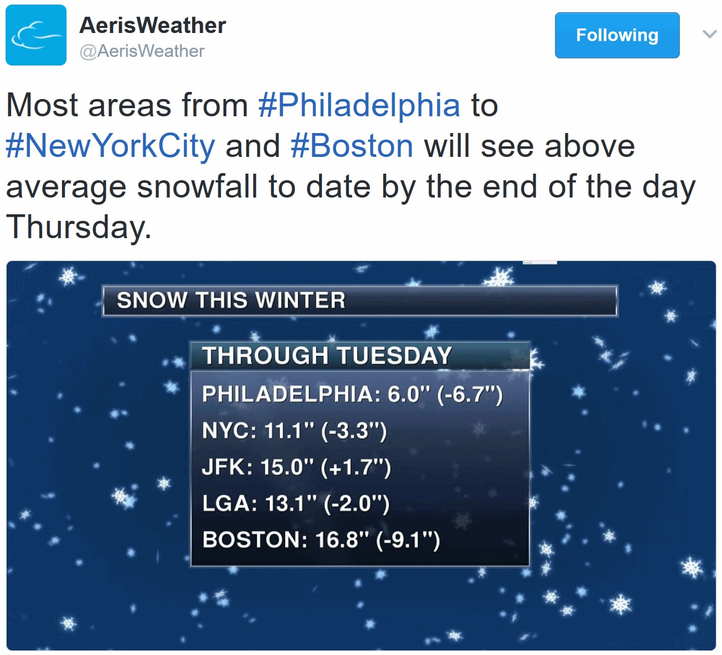
Light-Switch Winter. Fromm 60s to nearly a foot of snow in less than 24 hours? That's pretty impressive. Snowfall deficits are about to be erased, in a meteorological blink of an eye. Source: AerisWeather.
A Volatile Pattern. There's plenty of weather on both coasts; the biggest Nor'easter of a slow (easy) winter out east, while California, coastal Oregon and Washington get battered by high seas, heavy rains and mountain snows. High pressure dominates over the central USA with a rapid warming trend by Friday.
AerisWeather Briefing: Issued Wednesday, February 8th, 2017
* After near record warmth today in the Northeast, the weather will quickly take a turn for the worst as we head into late tonight and into Thursday as a coastal low rapidly develops.
* This will bring the heaviest snow so far this season to parts of the I-95 corridor, from Philadelphia to New York City and Boston, as we head into the day Thursday, with 6-12” of snow possible. This will have a major impact on the Thursday morning commute in both Philadelphia and New York City.
* Winter Storm Warnings have already been issued for these areas, which is where the heaviest of the snow is expected to fall.
* Winds will also be on the increase as the low pressure center rapidly deepens, leading to the potential of blizzard-like conditions.

Snow will end in Philadelphia as we head into the early afternoon hours Thursday, throughout the afternoon in New York City, and during the evening in Boston.


Breaking Down Expected Snowfall Totals Locally:
Washington D.C.:

Philadelphia, PA:

New York City:

Boston, MA:

Philadelphia, PA:

Blizzard-Like Conditions. With heavy snow expected to be falling, and winds on the increase (gusting 30-35 mph at times) due to the rapidly deepening system, near zero visibility is expected during the day along the eastern seaboard. This will help make travel even more difficult while the snow is falling tomorrow. BPI map series: AerisWeather.
Summary: As a low pressure center spins up off the Mid-Atlantic coast tonight, it will rapidly strengthen heading into Thursday, creating a winter storm for the Northeast. Winter Storm Warnings are already out for Philadelphia to New York City and Boston for the potential of 6-12” of snow through the day tomorrow with up to 2” per hour falling at times. Some of the heaviest snow for Philadelphia and New York City will fall during the morning rush hour, and with strong winds expected will create treacherous travel conditions. This will likely be the heaviest snow for the season so far along parts of the I-95 corridor. Snow will push north and east throughout the day and into the evening, and by tomorrow night most of the snow will be done across the large metropolitan cities.
D.J. Kayser, Meteorologist, AerisWeather
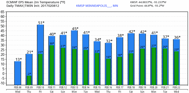
What February? Today's chill will get your attention, but March kicks in Friday and lingers into next week with 30s and 40s. MSP temperature ECMWF numbers: WeatherBell.
2 Weeks Out: Still Mild. The flow is forecast to be weak for late February; originating over the Pacific, not Canada. The result will be temperatures 10-20F. warmer than average across most of the USA.
Video credit: NASA.
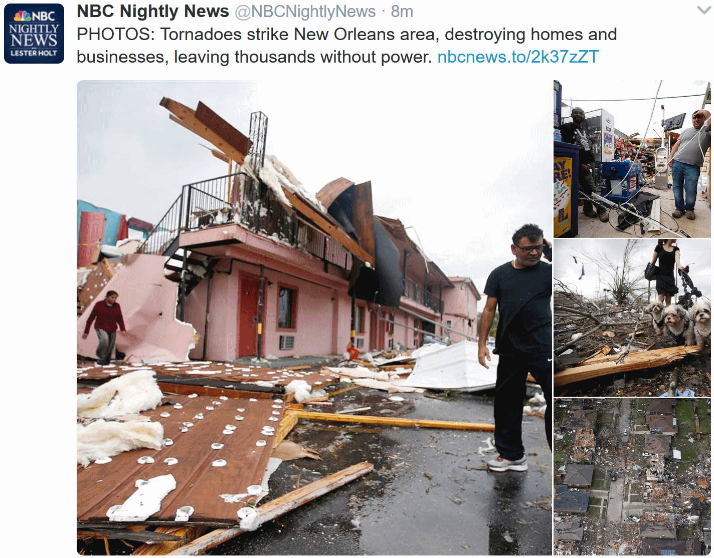
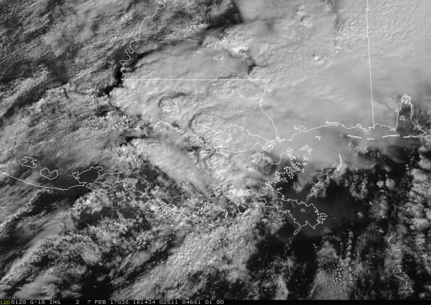
Is New Orleans in Tornado Alley? Technically no, but Dixie Alley? Yes. Check out the photos at NBCnews.com and you'll see the level of damage, which appears to be EF-3 or higher.
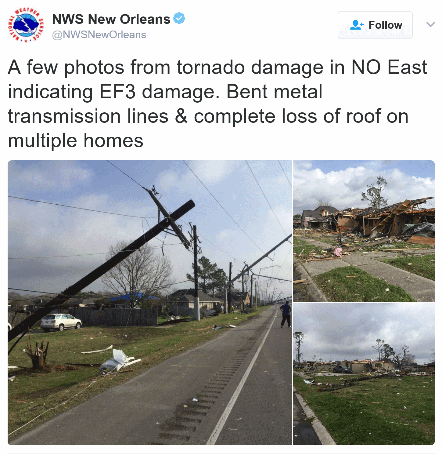
9 Tornadoes in Louisiana and Mississippi - 31 Injured - 9,400 Residents Without Power. ABC News has more details.
Broader Updrafts in Severe Storms May Increase Chance of Damaging Hail. ScienceDaily has the results of new research from Penn State: "...New research that Kumjian and Eli Dennis, graduate student in meteorology, published in the Journal of the Atmospheric Sciences, suggests that changes in environmental vertical wind shear influence the growth of "significant" hail -- bigger than two inches in diameter. Vertical wind shear is the variation in wind speed or direction from the bottom to the top of a layer in the atmosphere. The greater the difference in speed and/or directionality, the greater the shear. Hail forms when small particles like frozen raindrops -- hail embryos -- are ingested into a storm's updraft. Once they rise in the updraft, the embryos grow as additional liquid water freezes onto them..."
Photo credit: "A supercell thunderstorm passes near Elm Creek, Nebraska, in July 2014. Penn State meteorologists have been examining the widths of storms' updrafts to predict the likelihood of dangerous hail." Credit: NOAA.
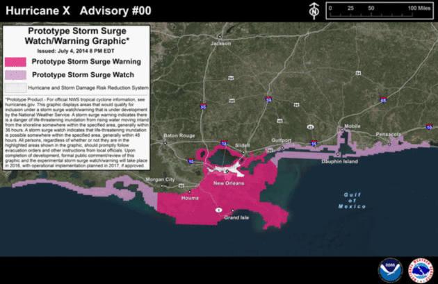
Graphic credit: "This example of a hurricane storm surge watch and warning map is based on a specific path of a slow-moving Category 2 hurricane. Note that part of the West Bank inside the post-Katrina hurricane levee system is in the warning area. Different paths by a Category 2 storm might produce different surge warning and watch areas, and a Category 3 or larger hurricane could result in the east bank area inside the levee system being included in a surge warning area." (National Hurricane Center).
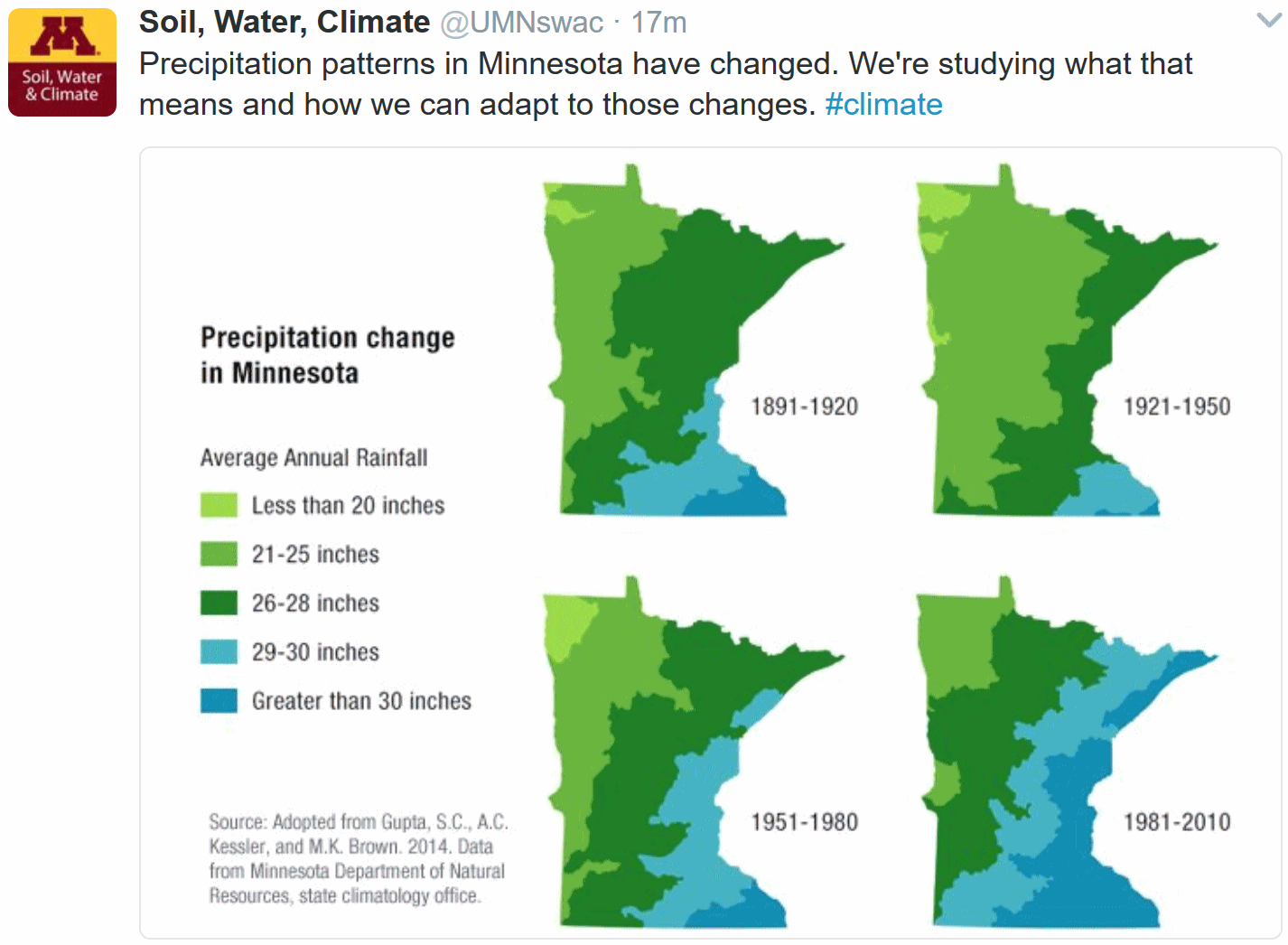
Minnesota Trending Warmer and Wetter. If there was any doubt in your mind a time series from The University of Minnesota Department of Soil, Water and Climate shows the actual trends since 1891.
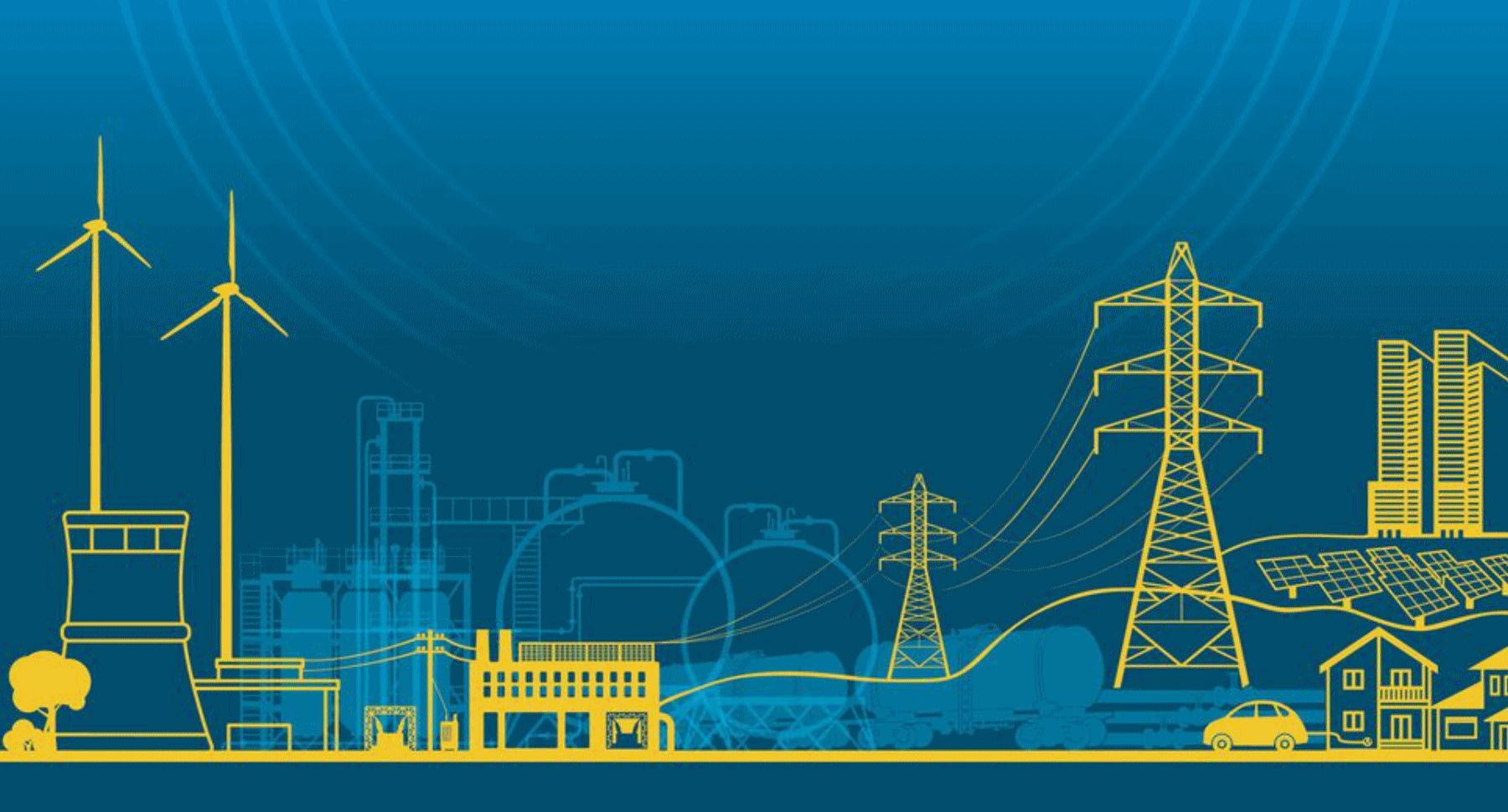
Warming-Driven Heat Waves Could Tax U.S. Electrical Grid. Here's a snippet from Climate Central: "That
increased demand means electricity providers will need to increase
capacity to guard against spikes in usage, potentially requiring up to
$180 billion of additional grid investment, the study, detailed Monday
in the journal Proceedings of the National Academy of Sciences,
suggests. “The big implication of this study is that adaptation to
rising temperature . . . will be more expensive than what the existing
models tell us,” co-author Catie Hausman, an energy and environmental economist at the University of Michigan, said. That means that reducing greenhouse gas emissions
now to avoid those future costs is also a more valuable prospect. That
Earth’s rising temperature will lead to more intense and more frequent extreme heat events is one of the basic tenets of climate change..." (Graphic credit: Department of Energy).
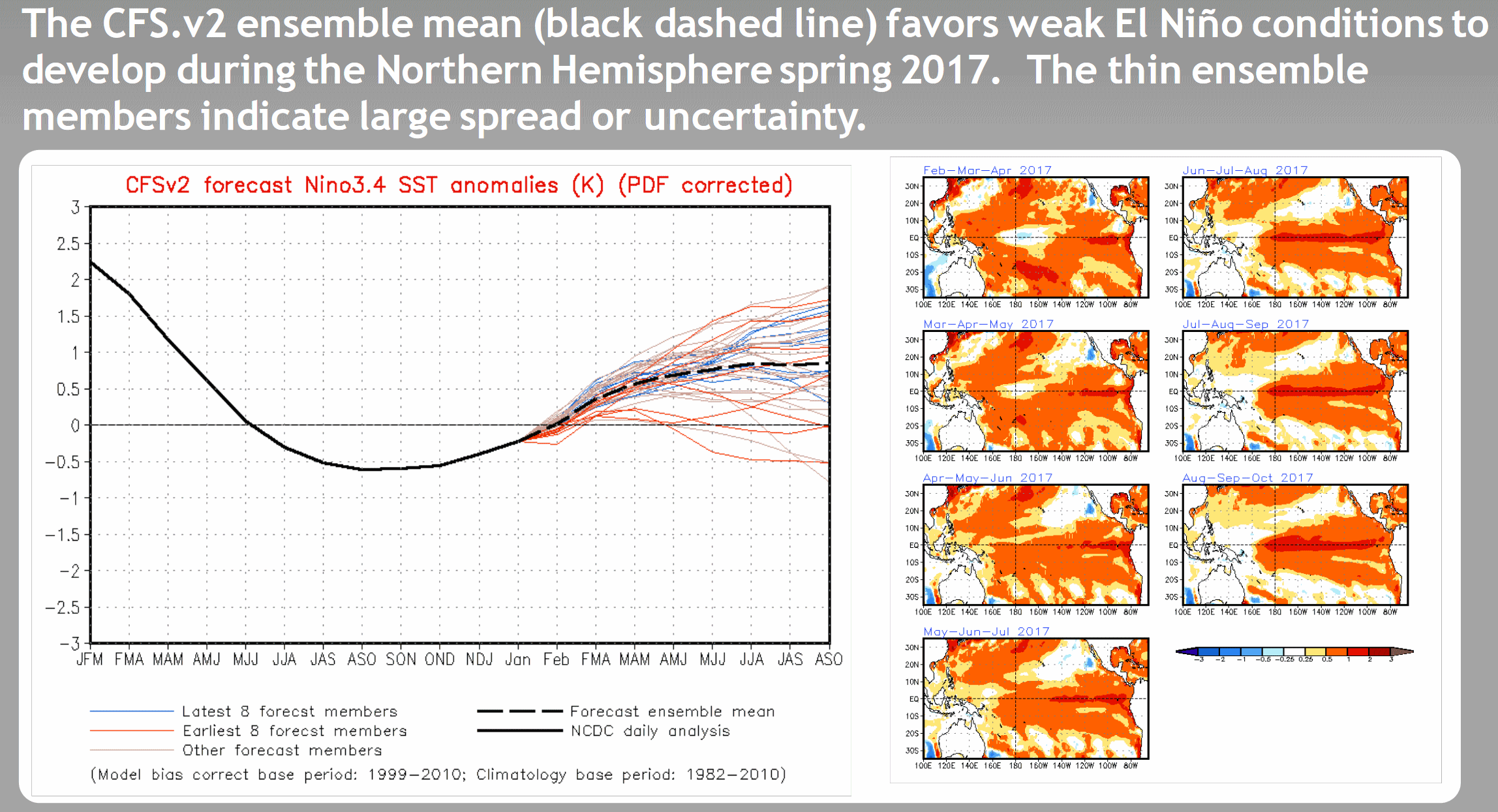
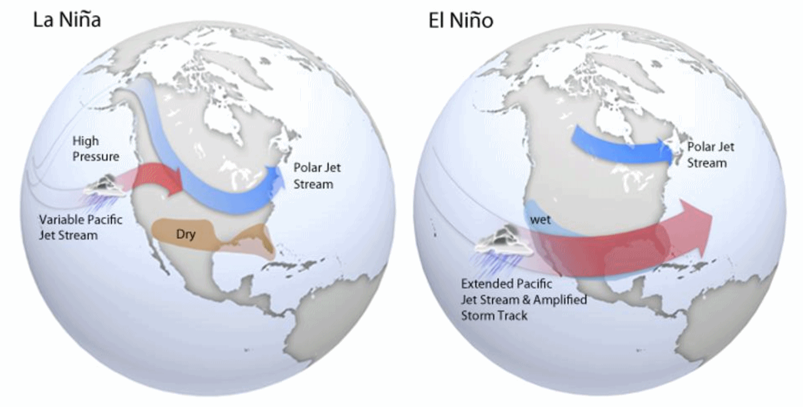
Weak El Nino Returning by Spring? For months I've been telling you how the pattern resembles an El Nino warming phase, especially the parade of damaging storms for the west coast and a bias toward warmth, nationwide. Now NOAA NCEP is predicting the onset of a "weak El Nino" for the Northern Hemisphere by spring. Go figure.
February Looks To Be Warm, And Not Because a Groundhog Said So. Marshall Shepherd explains at Forbes: "...Weather forecasts, like seasonal prediction models, try to predict the state of the atmosphere by solving complex hydrodynamic equations. However, weather models try to predict the exact "state" of the atmosphere or "weather" at specific date and time. However, the limits of the initial atmospheric states, observations, boundary conditions and assumptions about the evolving atmosphere limit accuracy to about 10 to 14 days. Seasonal forecasts cannot predict the exact daily "weather" at a given location three months in advance but rather try to assess the short-term climate state based on the ENSO (El Nino Southern Oscillation) cycle and other processes that show some level of predictability at monthly, seasonal or annual time scales. Other clues about seasonal predictability have been detected in an "alphabet soup of processes..." (Graphic credit: NOAA).
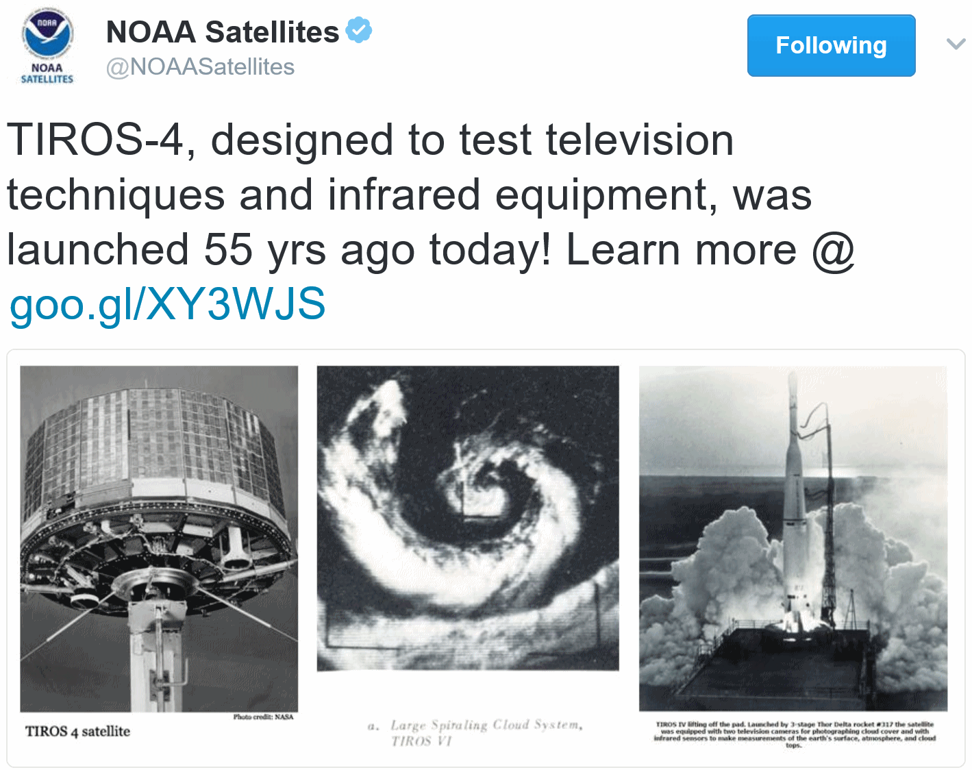
55 Year Anniversary of TIROS-4. OK, the onboard black and white TV cameras lasted about 4 months, but we suddenly had imagery from space, an entirely new perspective on weather and the planet - and it set a benchmark for everything that has come since. Details via NASA: "TIROS 4 (Television and InfraRed Observation Satellite) was a spin-stabilized meteorological spacecraft designed to test experimental television techniques and infrared equipment. The satellite was in the form of an 18-sided right prism, 107 cm in diameter and 56 cm high. The top and sides of the spacecraft were covered with approximately 9000 1- by 2-cm silicon solar cells. It was equipped with two independent television camera subsystems for taking cloudcover pictures and three radiometers (two-channel low-resolution, omnidirectional, and five-channel scanning) for measuring radiation from the earth and its atmosphere..."

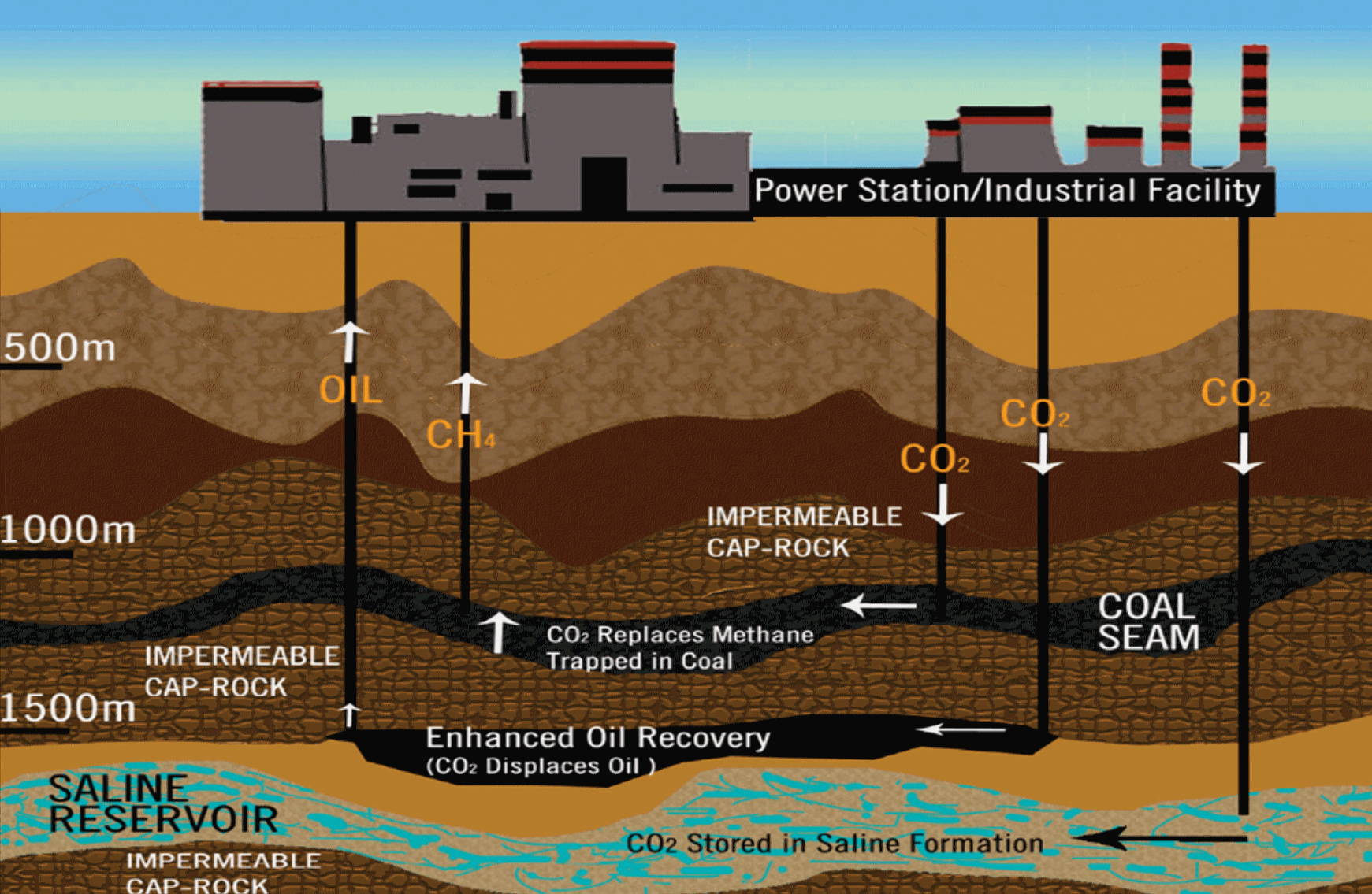
Climate Change: Coalition Supports Carbon Capture Tax Credit. Here's an excerpt of an intriguing story at TIME: "A rare coalition of energy companies, green groups and trade unions united this month to support a measure before Congress that helps fight greenhouse gas emissions by providing a tax credit for capturing and storing carbon dioxide. The provision — known as the Section 45Q tax credit — grants a tax incentive to energy and industrial companies that store carbon dioxide through a set of technologies commonly known as carbon capture and sequestration (CCS), rather than releasing the pollutant into the atmosphere. Support for a measure strengthening the tax credit came in the form of a letter sent last week to members of Congress. Representatives of environmental groups like the Natural Resources Defense Council, unions like the AFL-CIO and companies like Arch Coal, the country's second largest coal producer, signed the letter..."
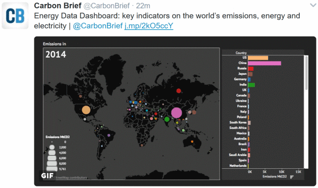
Image credit: World Resources Institute.
Photo credit: Jay Calderon.
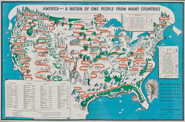
The Powerful 1940 Map That Depicts America as a Nation of Immigrants. Unless you have Native American blood odds are you are an immigrant - or a descendent of immigrants. Atlas Obscura has an interesting story: "In
the years leading up to the Second World War, isolationist sentiment
coursed pretty strongly throughout the United States. Some Americans
feared that immigrants were a threat to the country. Sound familiar? Then you’ll have no trouble understanding the reasons why the map below, titled America–A Nation of One People From Many Countries,
was published in 1940 by the Council Against Intolerance in America.
“With the exception of the Indian, all Americans or their forefathers
came here from other countries,” the illustrator Emma Bourne inscribed
on the map. The Council Against Intolerance commissioned Bourne’s work
in an effort to remind Americans that the U.S. had always defined itself
as a country of varied national origins and religious backgrounds..."
Map credit: "America—A
Nation of One People From Many Countries," by Emma Bourne published in
1940 by the Council Against Intolerance in America." From the collection of Stephen J. Hornsby/Courtesy the Osher Map Library and Smith Center for Cartographic Education

Best All-Inclusive Resorts in the Caribbean. If you need a mental health break check out the list from U.S. News: "U.S.
News ranks the best resorts by taking into account reputation among
professional travel experts, guest reviews and hotel class ratings. Use
the filters and settings below to help find the best resort for you.
Read the Best Hotels Methodology."

TODAY: Cold sunshine, feels like 0F. Winds: SW 5-10. High: 17
THURSDAY NIGHT: Mostly clear, rising temperatures. Low: 15
FRIDAY: Partly sunny, feels like late March. Winds: SW 10-15. High: 48
SATURDAY: A little light rain PM hours. Winds: E 5-10. Wake-up: 32. High: 41
SUNDAY: Peeks of sun, a bit cooler. Winds: NW 10-20. Wake-up: 29. High: 38
MONDAY: Mix of clouds and sun, quiet. Winds: W 7-12. Wake-up: 26. High: 45
TUESDAY: Some sun, still dry. Winds: NW 10-15. Wake-up: 25. High: 43
WEDNESDAY: More sun, early case of spring fever? Winds: W 7-12. Wake-up: 27. High: 46
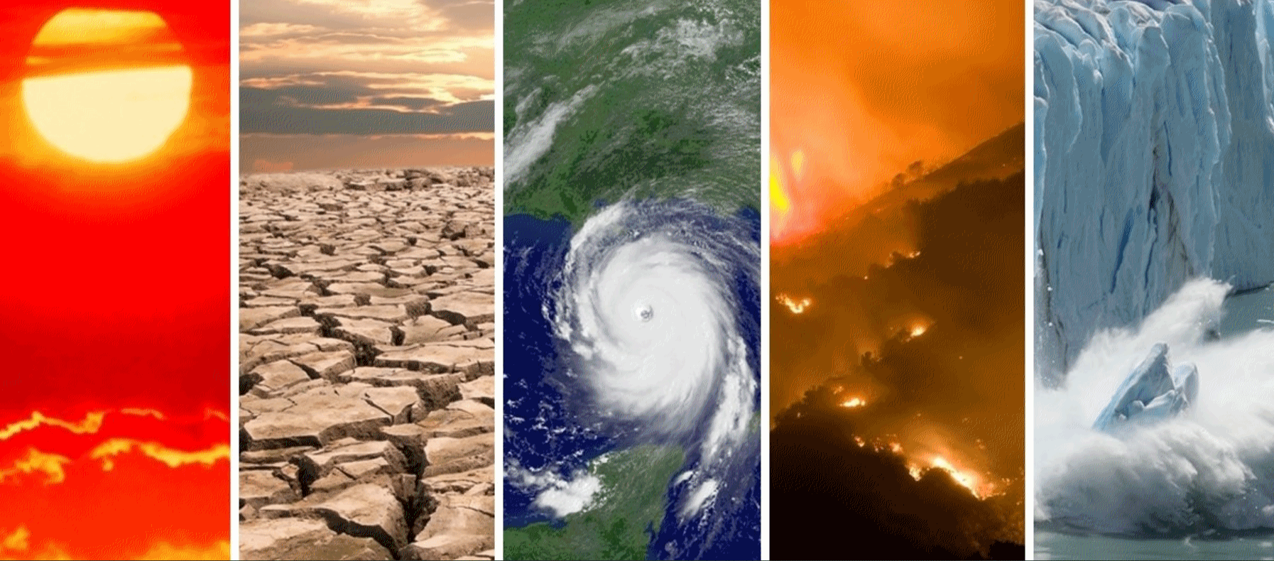
Climate Stories...
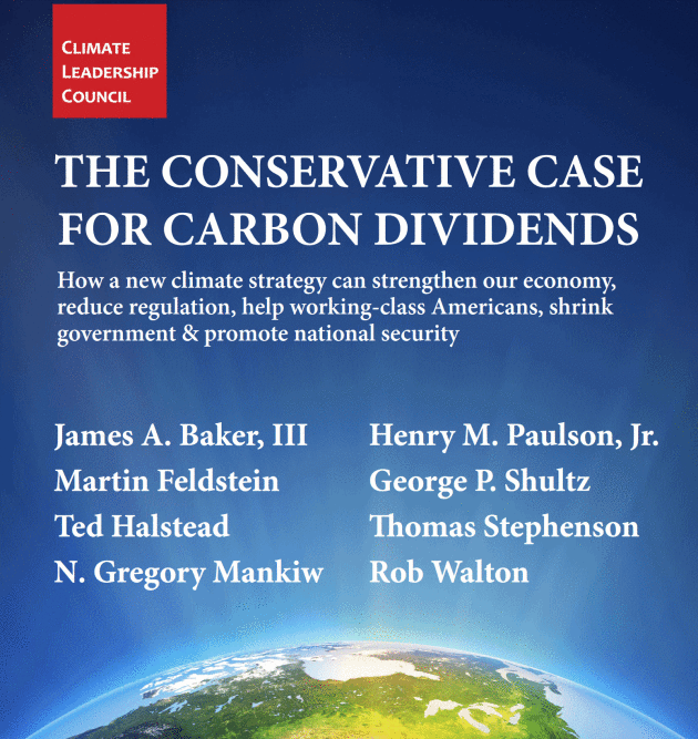
The Plan referenced above is here.
A Conservative Answer to Climate Change. The same group of conservatives pushing for a revenue-neutral carbon tax wrote an Op-Ed for The Wall Street Journal: "Thirty years ago, as the atmosphere’s protective ozone layer was dwindling at alarming rates, we were serving proudly under President Ronald Reagan. We remember his leading role in negotiating the Montreal Protocol, which continues to protect and restore the delicate ozone layer. Today the world faces a similar challenge: the threat of climate change. Just as in the 1980s, there is mounting evidence of problems with the atmosphere that are growing too compelling to ignore. And, once again, there is uncertainty about what lies ahead. The extent to which climate change is due to man-made causes can be questioned. But the risks associated with future warming are so severe that they should be hedged. The responsible and conservative response should be to take out an insurance policy..." (Image credit: NASA).
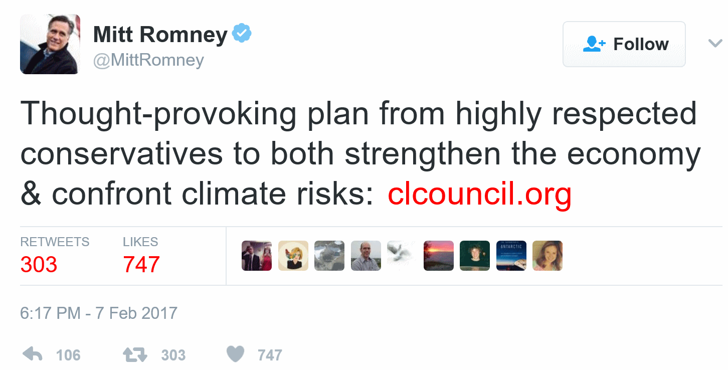

Photo credit: "James A. Baker, seen here at former first lady Nancy Reagan’s funeral in March 2016, is a member of the Climate Leadership Council. Despite its impeccable Republican credentials, the group faces long odds with its carbon-tax idea." (Jae C. Hong/Associated Press).
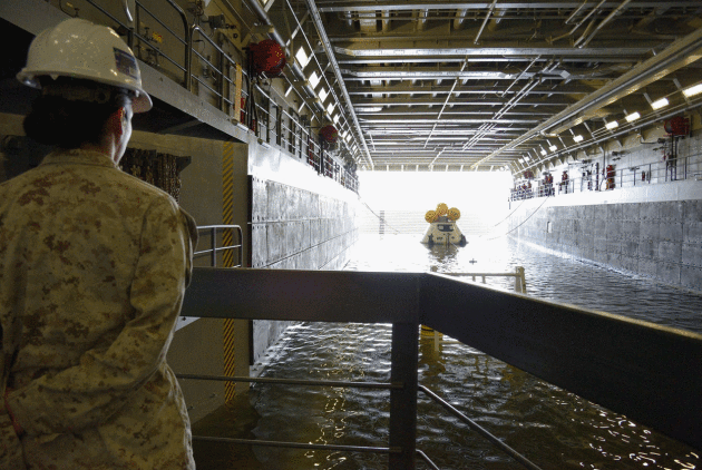
Photo credit: "Tests of the Orion spacecraft were made at Naval Station Norfolk in August 2013. The low-lying base is at risk from rising seas." Photograph by NASA, eyevine, Redux.
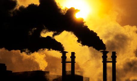
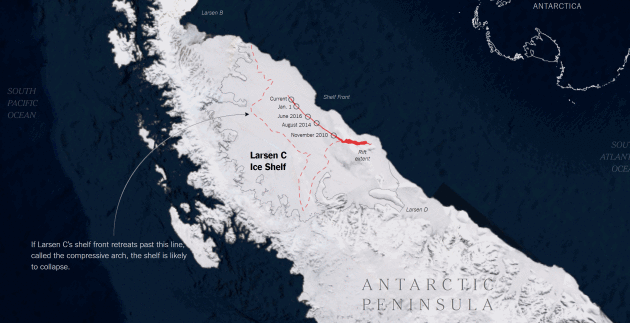
Image credit: 2016 Microsoft Corporation Earthstar Geographics.
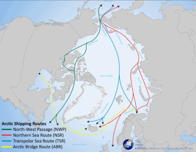
Image credit: The Arctic Institute.
3 Ways You Can Help the World's Climate Scientists Right Now. Dr. Marshall Shepherd has some good suggestions at Forbes: "I often sit back and watch certain things quietly. This past week has been one of those moments. An article this weekend in the British media brought up the old and oft disproven argument about the"warming pause." However, as scientists dug into this latest desperate "Hail Mary" pass, it was apparent that there was more to this latest saga. My colleagues Phil Plait at Blastr and Andrew Freedman at Mashable have written excellent pieces laying out how scientists debunked these latest claims. They also fill in other pieces to this rather odd story. This latest drama just highlights the level of innuendo and confirmation bias that still can rear its head in the climate discussion. However, my focus herein is different. This week I saw three opportunities that I wanted to share with the broader public that can actually help climate scientists rather than continually distracting them..." (Image credit: NOAA).
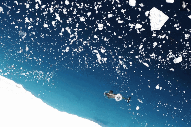
Image credit: Donald LeRoi, NOAA Southwest Fisheries Science Center. "Climate scientists have worked hard for decades to prove climate change. Why is the US House Committee on Science, Space and Technology working so hard not to believe them?"
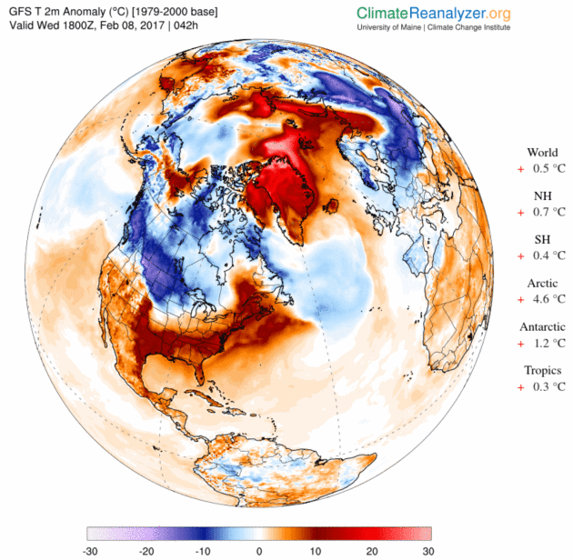
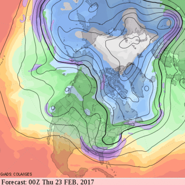
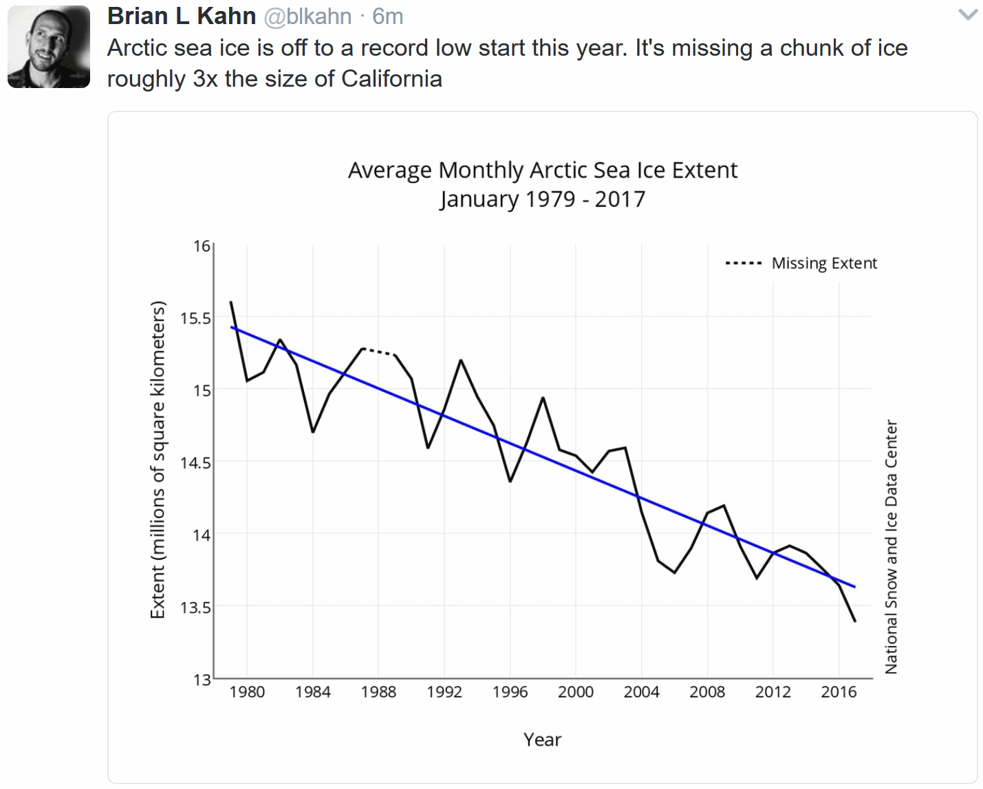
Image credit: "Abnormally warm air is expected to reach the North Pole by Thursday." Credit: Climate Reanalyzer
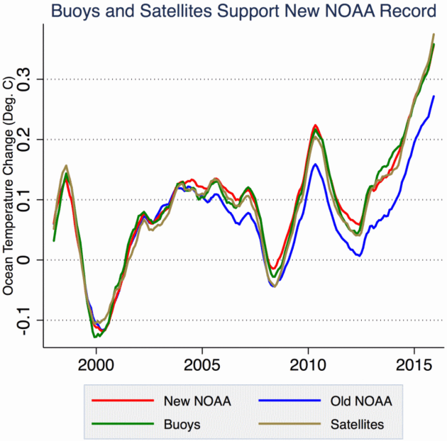
No Data Manipulation in 2015 Climate Study, Researchers Say.
There was no temperature "pause"; additional heat energy was absorbed
by ocean water, especially in the Pacific. Here's an excerpt at The New York Times: "...Dr. Hausfather was one of the authors of a review of the NOAA ocean data, which showed the most change. The paper,
published in January, compared the old and new NOAA data with
independent data from satellites, buoys and other sources and found that
the new data matched the independent data more closely. The result, he
wrote, “strongly suggests that NOAA got it right and that we have been
underestimating ocean warming in recent years.” In an interview
on Monday with E&E News, Dr. Bates appeared to distance himself
from some of what he wrote in the blog post, and from the way his
criticisms were portrayed in the Mail on Sunday article. “The issue here
is not an issue of tampering with data,” he said, “but rather really of
timing of a release of a paper that had not properly disclosed
everything it was...”
Graphic credit: CarbonBrief fact check. "Global
sea surface temperatures from the old NOAA record (ERSSTv3b), the new
NOAA record (ERSSTv4), and instrumentally homogenous records from buoys
and satellites. See Hausfather et al 2017 for details, as well as
comparisons with shorter Argo-based records."
Think Climate Change is a Hoax? Visit Norway. Here's an excerpt from Climate Home: "...One concern is that as the ice melts, historic claims from Russia, Canada and the US together with other Arctic nations on portions of the oil and mineral-rich ocean will cause friction. “In the mid- to far- term, as ice recedes and resource extraction technology improves, competition for economic advantage and a desire to exert influence over an area of increasing geostrategic importance could lead to increased tension,” reads the US strategy document. Another worry is that ice-free routes will see a surge in shipping. According to the UN’s IPCC climate science panel Arctic shipping lanes could be open for four months a year by 2050. There are already signs of an uptick in traffic..."
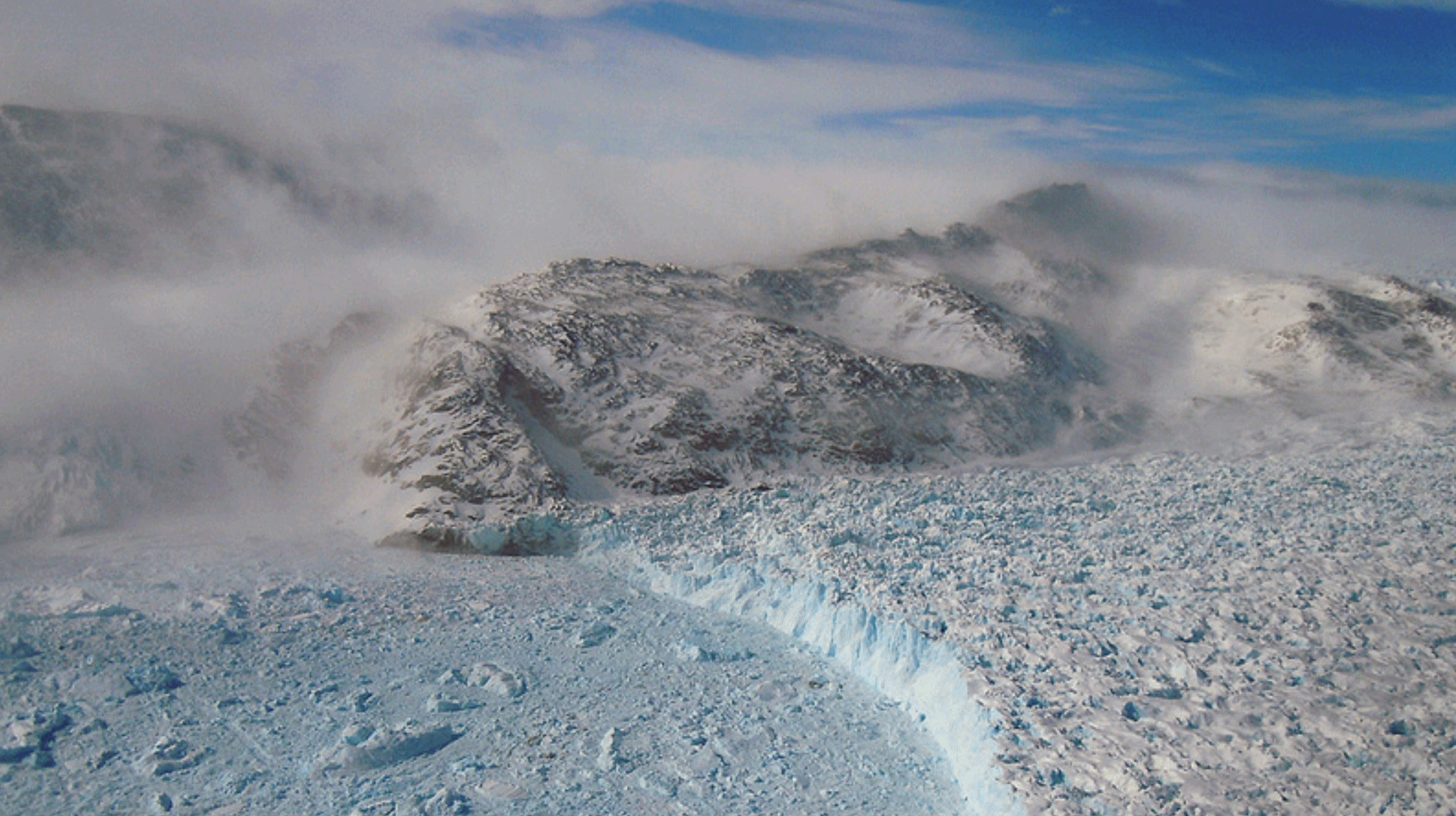
Photo credit: "Gyldenlove Glacier, Greenland." (Pic: NASA Goddard Space Flight Center)
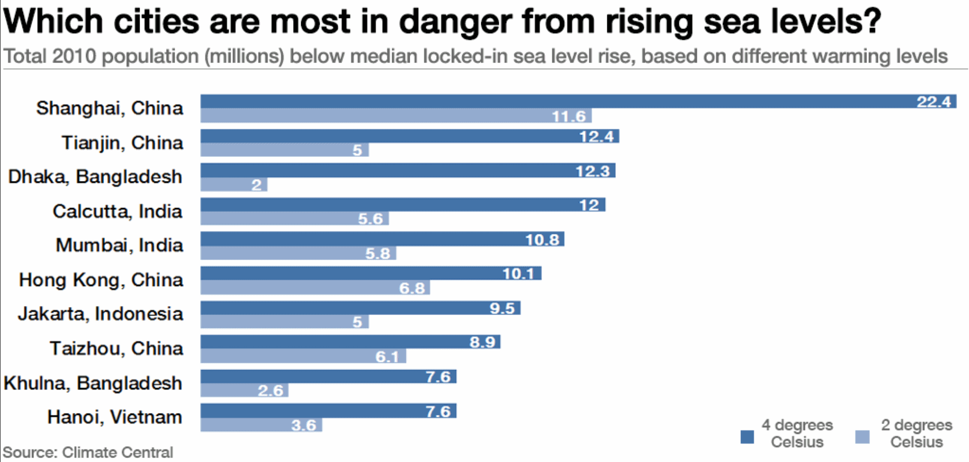
Coastal Megacities vs. The Sea. The Center for Climate and Security has a link to a paper, highlighting risks to some of the world's most populated cities: "Cities are on the sharp end of a range of risks from criminal violence, terrorism and war to demographic pressures, to climate and environmental change. Coastal megacities are especially at risk given the specific impacts of climate change they face, including accelerated global sea-level rise, increased storm frequency and severity, and destruction to critical infrastructure such as port facilities, rail and road linkages, and energy installations, all of which are amplified as urban populations become ever larger. All these risks can lead to the loss of livelihoods as well as significant loss of life itself. Furthermore, the interaction of these risks could exceed the existing coping capacity of communities and governments and contribute to an increase in insecurity and possibly violent conflict." (Graphic credit: Climate Central).
No comments:
Post a Comment