"Black Sunday" - April 30th, 1967
Sunday marks the 50th anniversary of "Black Sunday", a day which brought F4 tornadoes across southern Minnesota and 20 foot waves in Duluth. Four people lost their lives due to the waves in Duluth, and 13 deaths were linked to tornadoes across Minnesota and Iowa. The Weather Service Office in Duluth gives some perspective about the day and the impacts in Duluth - I'll quote some of them below, but you can read more by clicking here.
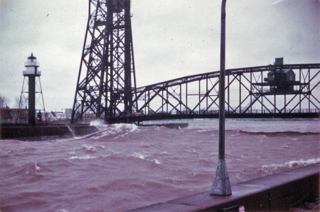
Image: 1967 U.S. Coast Guard Photo (for release) by Fireman Ronald Prei / via PS1 Kevin Rofidal, MSU Duluth / via NWS DuluthQuote from NWS Duluth article: "With 20 foot waves and gale-force winds pounding the Duluth ship canal and over the pier on the evening of Sunday, April 30, 1967, many flocked as they still do today to watch the storm down by the lake. This storm brought 45 mph gusty winds coupled with a lake temperature of 36 °F to the shoreline. The Halverson brothers, Eric, Nathan, and Arthur, like many others went down to the pier to get a view of the waves crashing onto the walkways. Venturing along the north pier, a 20 foot wave crashed over the wall, sweeping the brothers off the pier. Coast Guardsmen were called into a rescue attempt to save the brothers. In their attempt, Boatswain Mate First Class Edgar A. Culbertson was swept off his feet by a strong wave into the canal. The Halverson brothers and Culbertson lost their lives."
 In
addition to those waves, the system also brought tornadoes across
southern Minnesota and into Iowa, impacting cities like Waseca and
Albert Lea. A total of four F4 tornadoes were reported that day, with a
total of 21 tornadoes. The Waseca Virtual History Museum has pictures of the damage that occured in the town.
In
addition to those waves, the system also brought tornadoes across
southern Minnesota and into Iowa, impacting cities like Waseca and
Albert Lea. A total of four F4 tornadoes were reported that day, with a
total of 21 tornadoes. The Waseca Virtual History Museum has pictures of the damage that occured in the town.
______________________________
Historical May Twin Cities Snow
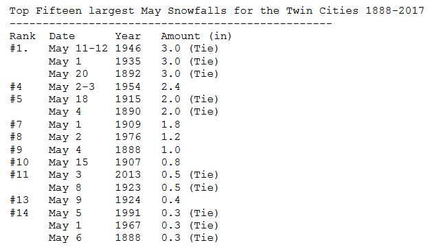 Yes,
at times it does snow in May! You just have to think back to a few
years to the beginning of May 2013, when 0.5" fell in the Twin Cities
but a foot and a half fell across portions of southern Minnesota! The Minnesota Climatology Working Group took a look back at historical May snowfalls in the Twin Cities,
and found that the top snow during the month has only been 3" of snow.
Could we get a little snow in the upcoming days? More on that in a
little bit.
Yes,
at times it does snow in May! You just have to think back to a few
years to the beginning of May 2013, when 0.5" fell in the Twin Cities
but a foot and a half fell across portions of southern Minnesota! The Minnesota Climatology Working Group took a look back at historical May snowfalls in the Twin Cities,
and found that the top snow during the month has only been 3" of snow.
Could we get a little snow in the upcoming days? More on that in a
little bit.
______________________________
A Soaking Cold Rain Expected To End April
By D.J. Kayser, filling in for Paul Douglas
Minnesota weather always seems to have something interesting hiding up its sleeve. One minute it’s warm and sunny, the next brings you accumulating snow.
Even with the recent round of cool weather, the odds are still good that April will be the twentieth consecutive month with above average temperatures in the Twin Cities. This is a streak that stretches back to September of 2015.
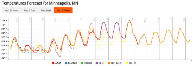
And yet, here we are talking about the potential of snow in early May! A storm system will bring rain to a good portion of southern Minnesota Sunday, with amounts potentially topping an inch across the metro. Enough cold air will wrap in Sunday Night into Monday to bring at least a plowable snow from Marshall to Brainerd and Hibbing. We might see a few snowflakes early and late Monday in the metro, but only minor slushy accumulations at most are expected.
The good news? After this system, we begin a warming trend, with highs approaching 70 once again by next weekend. Is this upcoming storm winter's final punch? We can only hope so.
Sunday marks the 50th anniversary of "Black Sunday", a day which brought F4 tornadoes across southern Minnesota and 20 foot waves in Duluth. Four people lost their lives due to the waves in Duluth, and 13 deaths were linked to tornadoes across Minnesota and Iowa. The Weather Service Office in Duluth gives some perspective about the day and the impacts in Duluth - I'll quote some of them below, but you can read more by clicking here.
Image: 1967 U.S. Coast Guard Photo (for release) by Fireman Ronald Prei / via PS1 Kevin Rofidal, MSU Duluth / via NWS DuluthQuote from NWS Duluth article: "With 20 foot waves and gale-force winds pounding the Duluth ship canal and over the pier on the evening of Sunday, April 30, 1967, many flocked as they still do today to watch the storm down by the lake. This storm brought 45 mph gusty winds coupled with a lake temperature of 36 °F to the shoreline. The Halverson brothers, Eric, Nathan, and Arthur, like many others went down to the pier to get a view of the waves crashing onto the walkways. Venturing along the north pier, a 20 foot wave crashed over the wall, sweeping the brothers off the pier. Coast Guardsmen were called into a rescue attempt to save the brothers. In their attempt, Boatswain Mate First Class Edgar A. Culbertson was swept off his feet by a strong wave into the canal. The Halverson brothers and Culbertson lost their lives."
______________________________
Historical May Twin Cities Snow
______________________________
A Soaking Cold Rain Expected To End April
By D.J. Kayser, filling in for Paul Douglas
Minnesota weather always seems to have something interesting hiding up its sleeve. One minute it’s warm and sunny, the next brings you accumulating snow.
Even with the recent round of cool weather, the odds are still good that April will be the twentieth consecutive month with above average temperatures in the Twin Cities. This is a streak that stretches back to September of 2015.
And yet, here we are talking about the potential of snow in early May! A storm system will bring rain to a good portion of southern Minnesota Sunday, with amounts potentially topping an inch across the metro. Enough cold air will wrap in Sunday Night into Monday to bring at least a plowable snow from Marshall to Brainerd and Hibbing. We might see a few snowflakes early and late Monday in the metro, but only minor slushy accumulations at most are expected.
The good news? After this system, we begin a warming trend, with highs approaching 70 once again by next weekend. Is this upcoming storm winter's final punch? We can only hope so.
______________________________
Extended Forecast for Minneapolis
SUNDAY: A cold rain. Gusty winds. High 45. Low 38. Chance of precipitation 80%. Winds NE 10-20 mph, gusting to 30 mph in the afternoon.
MONDAY: Rain continues. A few flakes mix in? High 43. Low 36. Chance of precipitation 80%. Wind N 10-15 mph.
TUESDAY: Isolated shower early. Mainly cloudy. High 53. Low 40. Chance of precipitation 20%. Wind NW 5-10 mph.
WEDNESDAY: Peaks of sun. Late day shower chance. High 60. Low 43. Chance of precipitation 20%. Wind S 5-10 mph.
THURSDAY: Isolated shower early. Turning sunny. High 62. Low 45. Chance of precipitation 20%. Wind NW 5-10 mph.
FRIDAY: Mainly sunny skies and a bit warmer. High 65. Low 48. Chance of precipitation 0%. Wind SW 5-10 mph.
SATURDAY: Highs approach 70 with blue skies. High 69. Low 52. Chance of precipitation 0%. Wind SW 5-10 mph.
______________________________
This Day in Weather History
April 30th
2004: After a high temperature of 91 on the previous day in the Twin Cities, the mercury tumbles to 47 degrees by the morning. St. Cloud sheds 50 degrees over 12 hours.
1967: Tornadoes hit southern Minnesota. Some of the towns affected were Albert Lea, Waseca, Wells, and Owatonna.
______________________________
Average Temperatures & Precipitation for Minneapolis
April 30th
Average High: 65F (Record: 91F set in 1952)
Average Low: 44F (Record: 24F set in 1903)
Average Precipitation: 0.11" (Record: 1.53" set in 1954)
Average Snow: 0.0" (Record: 3.1" set in 1984)
______________________________
Sunrise/Sunset Times for Minneapolis
April 30th
Sunrise: 6:03 AM
Sunset: 8:17 PM
*Length Of Day: 14 hours, 11 minutes and 27 seconds
*Daylight Added Since Yesterday: ~2 minutes and 44 seconds
*Next Sunrise At/Before 6 AM: May 2nd (6:00 AM)
*Next Sunset At/After 8:30 PM: May 11th (8:31 PM)
______________________________
Minnesota Weather Outlook
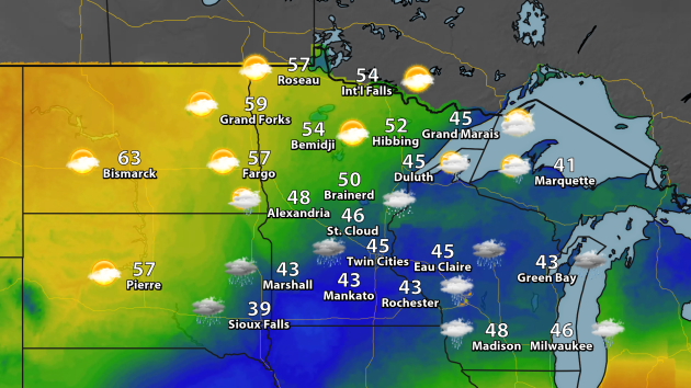
Sunday
will be a bit of a topsy-turvy day across Minnesota, as the cooler
temperatures will be across southern Minnesota. This is where we expect
to see rain (and even a rain/snow mix). The warmer weather will be
across northern Minnesota, with areas like International Falls and
Bemidji reaching the 50s under a mix of clouds and sun.
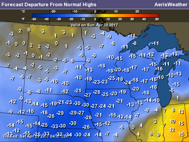
With
highs in the 30s and 40s across southern Minnesota, it'll be a good
15-25 degrees cooler than average during the day Sunday. Where there is
sunshine - across northern Minnesota - temperatures will be a lot closer
to average.
The
good news is that the cooler weather doesn't last... although you have
to get through the next couple days. 50s will return to the Twin Cities
by Tuesday, with 60s likely by the end of the week. Some of the model
data is hinting at a return to the 70s next weekend and into the next
week before a touch cooler weather works back in.
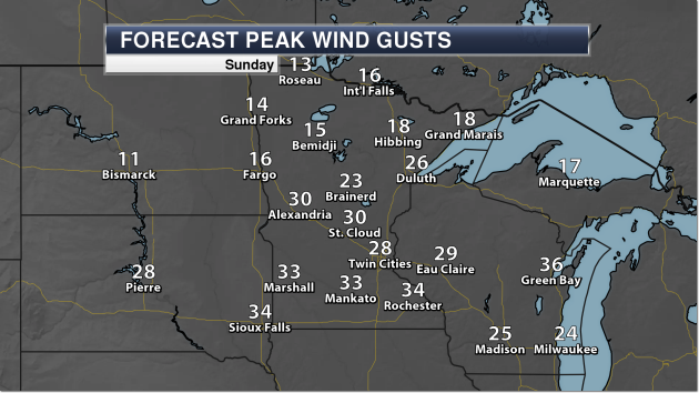 It
will also be a gusty Sunday across southern Minnesota with that cold
rain, as wind gusts could top 30 mph in spots. It looks like the
windiest weather will be during the afternoon hours, along with some of
the heavier rainfall.
It
will also be a gusty Sunday across southern Minnesota with that cold
rain, as wind gusts could top 30 mph in spots. It looks like the
windiest weather will be during the afternoon hours, along with some of
the heavier rainfall.
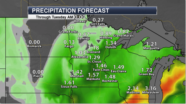 As
this system moves through the region, precipitation amounts could
easily top 1" across central and southern Minnesota, as well as along
the North Shore. The heaviest of the rain, however, should remain off to
our south and west, where places like Madison and Milwaukee could pick
up on 2-3"+ of rain through Tuesday morning.
As
this system moves through the region, precipitation amounts could
easily top 1" across central and southern Minnesota, as well as along
the North Shore. The heaviest of the rain, however, should remain off to
our south and west, where places like Madison and Milwaukee could pick
up on 2-3"+ of rain through Tuesday morning.
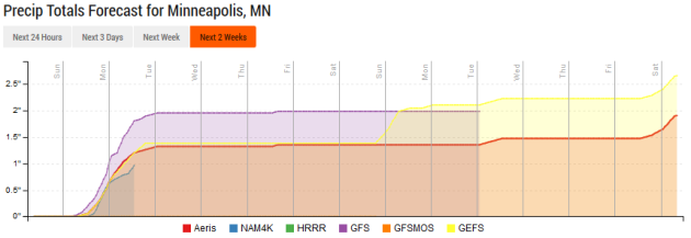 As
we look long term at precipitation, we do work into a little bit of a
break in the rain as we head later into the week, helping conditions dry
back out a bit.
As
we look long term at precipitation, we do work into a little bit of a
break in the rain as we head later into the week, helping conditions dry
back out a bit.
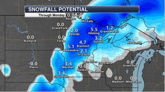 Meanwhile,
yes, we are still tracking the potential of snow across parts of the
state as we head into the beginning of May. The best chance of seeing
accumulating snow appears to be off in western/central/northern
Minnesota, where snow totals could top five inches. While it will start
off as rain in these areas Sunday, the precipitation will change over to
snow Sunday Night and last into Monday.
Meanwhile,
yes, we are still tracking the potential of snow across parts of the
state as we head into the beginning of May. The best chance of seeing
accumulating snow appears to be off in western/central/northern
Minnesota, where snow totals could top five inches. While it will start
off as rain in these areas Sunday, the precipitation will change over to
snow Sunday Night and last into Monday.
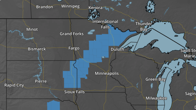 Due to the potential of heavy snow totaling 3-6", Winter Storm Watches have been issued from southwest to northeast Minnesota.
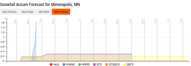 Here
in the Twin Cities we could see a slight accumulation of slushy snow,
but the odds show that the main snow show should stay to our north and
west.
Here
in the Twin Cities we could see a slight accumulation of slushy snow,
but the odds show that the main snow show should stay to our north and
west.
______________________________
National Weather Outlook
Sunday Forecast
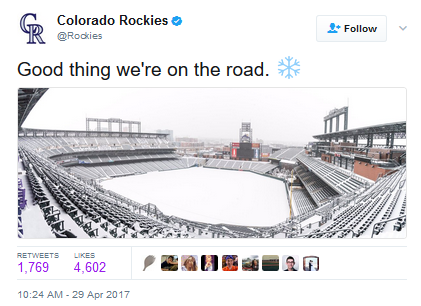
 The
heaviest snow over the next few days continues to be across parts of
Colorado and Kansas, stretching up into the upper Midwest. Did anyone
mention to Mother Nature that Monday is the start of May?
The
heaviest snow over the next few days continues to be across parts of
Colorado and Kansas, stretching up into the upper Midwest. Did anyone
mention to Mother Nature that Monday is the start of May?
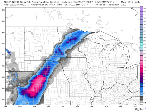 Here's
the forecast amounts from local National Weather Service offices, with
the potential of 6"+ of snow from the panhandles of Texas and Oklahoma
northward into the upper Midwest (at least in spots).
Precipitation Outlook Through Thursday Morning
Here's
the forecast amounts from local National Weather Service offices, with
the potential of 6"+ of snow from the panhandles of Texas and Oklahoma
northward into the upper Midwest (at least in spots).
Precipitation Outlook Through Thursday Morning
GOES-16 To Help With Wildfires As Well
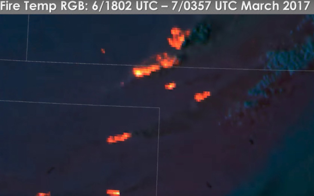 The
new GOES-16 satellite will not only bring us better satellite imagery
to real time weather decisions, but also will provide better information
for fighting wildfires. More from Wildfire Today: "During
the siege of wildfires on March 6 and 7 in Kansas, Oklahoma, and
northern Texas strong winds before and after a frontal passage fanned
existing small fires into huge firestorms that burned about a million
acres in Kansas alone. Six people were killed and firefighters were
stretched far beyond the capabilities of the mostly rural departments
they served. While this was going on a few meteorologists with access
to the new, still being tested GOES-16 satellite were monitoring the
emerging wildfire situation."
The
new GOES-16 satellite will not only bring us better satellite imagery
to real time weather decisions, but also will provide better information
for fighting wildfires. More from Wildfire Today: "During
the siege of wildfires on March 6 and 7 in Kansas, Oklahoma, and
northern Texas strong winds before and after a frontal passage fanned
existing small fires into huge firestorms that burned about a million
acres in Kansas alone. Six people were killed and firefighters were
stretched far beyond the capabilities of the mostly rural departments
they served. While this was going on a few meteorologists with access
to the new, still being tested GOES-16 satellite were monitoring the
emerging wildfire situation."
Trouble In Paradise?
 Hawaii
is in the process of banning sunscreens that contain the chemical
oxybenzone. Why are they attempting to do this? The chemical is killing
coral reefs. More from Popular Science: "The
waters surrounding Hawaii's eight main islands contain more than
410,000 acres of living coral reefs. If strung together, the reefs would
be bigger than Oahu, Hawaii’s third largest island. And because of
Hawaii’s geographic isolation, the reefs support unique life. The
Hawaiian Monk Seal, the Bandit Angelfish—even some of the types of coral
that comprise the reef itself—are found nowhere else on earth. It’s a
shame that our sunscreen might be killing them." (Image: NOAA)
Hawaii
is in the process of banning sunscreens that contain the chemical
oxybenzone. Why are they attempting to do this? The chemical is killing
coral reefs. More from Popular Science: "The
waters surrounding Hawaii's eight main islands contain more than
410,000 acres of living coral reefs. If strung together, the reefs would
be bigger than Oahu, Hawaii’s third largest island. And because of
Hawaii’s geographic isolation, the reefs support unique life. The
Hawaiian Monk Seal, the Bandit Angelfish—even some of the types of coral
that comprise the reef itself—are found nowhere else on earth. It’s a
shame that our sunscreen might be killing them." (Image: NOAA)
Offshore Arctic Drilling
President Trump signed an executive order Friday to try and restore offshore drilling in the Arctic. What can Trump actually accomplish here? More from InsideClimate News: "The area in question includes the entirety of the Chukchi Sea and most of the Beaufort Sea off Alaska, as well as a stretch of the Atlantic Ocean from Massachusetts to Virginia. Obama's executive order relied on his powers under the Outer Continental Shelf Lands Act of 1953 (OCSLA), which allows a president to withdraw certain areas from drilling."
EPA Webpages Disappear
Friday night the EPA wiped climate data off their website after announcing that there would be changes made. The Washington Post has more: "One of the websites that appeared to be gone had been cited to challenge statements made by the EPA’s new administrator, Scott Pruitt. Another provided detailed information on the previous administration’s Clean Power Plan, including fact sheets about greenhouse gas emissions on the state and local levels and how different demographic groups were affected by such emissions."
______________________________
Thanks for checking in and have a great Sunday! Don't forget to follow me on Twitter (@dkayserwx) and like me on Facebook (Meteorologist D.J. Kayser)!
- D.J. Kayser

______________________________
National Weather Outlook
Sunday Forecast
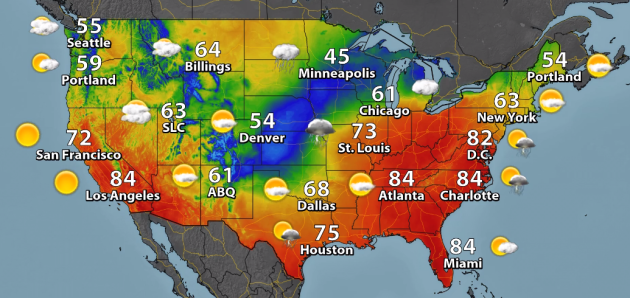
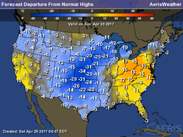
After
record breaking temperatures across the eastern U.S. Saturday,
temperatures will moderate just a little bit with highs in the 80s
expected for D.C., Charlotte and Atlanta. Some of the coolest weather
Sunday will be from western Kansas into the upper Midwest, where highs
will only be in the 30s and 40s due to a storm system bringing rain and
snow to the region. Meanwhile, parts of southern Texas that have been
approaching 100 the past few days will only be in the 80s due to a cool
front that has passed through the region and is heading east through the
Southeast on Sunday.
With
rain and snow impacting parts of the central Plains and upper Midwest,
highs will be a good 15-35 degrees below average for this time of year
on Sunday. The bulk of the warmth can still be found from the Ohio
Valley into the Southeast, however temperatures will be cooler for the
second half of the weekend versus on Saturday.
Snow Potential Through Monday Evening
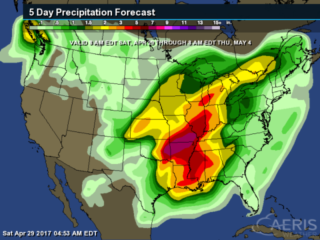
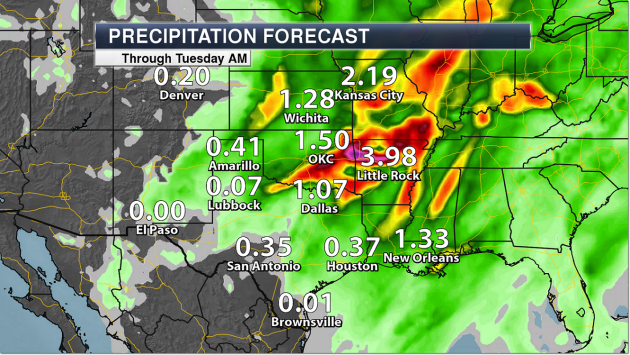
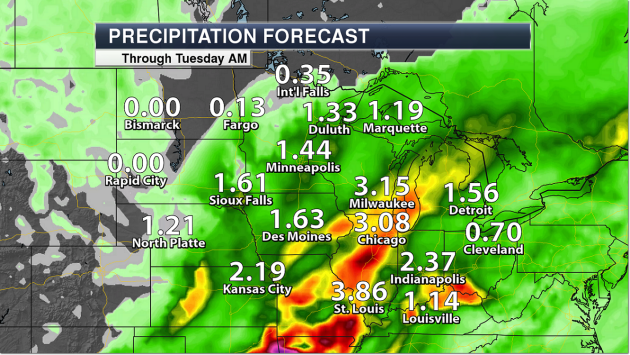
A
life-threatening heavy rain/flooding situation will continue over the
central U.S. as we head into early next week. From Saturday through
Thursday, rainfall totals could easily top a half a foot in parts of the
region.
Heavy Central U.S. Rain
Some
of the heaviest totals over the next several days will be across
Oklahoma, Arkansas and Missouri, where 2-6”+ of rain can be expected,
especially over the Ozarks. Even Little Rock, though, could pick up
almost 4” of rain through Tuesday morning.
It
isn’t only the Southern Plains dealing with heavy rainfall, though.
Over 3” of rain is possible through early next week as far north as
Chicago and Milwaukee, leading to the potential of flash flooding here
as well.
______________________________GOES-16 To Help With Wildfires As Well
Trouble In Paradise?
Offshore Arctic Drilling
President Trump signed an executive order Friday to try and restore offshore drilling in the Arctic. What can Trump actually accomplish here? More from InsideClimate News: "The area in question includes the entirety of the Chukchi Sea and most of the Beaufort Sea off Alaska, as well as a stretch of the Atlantic Ocean from Massachusetts to Virginia. Obama's executive order relied on his powers under the Outer Continental Shelf Lands Act of 1953 (OCSLA), which allows a president to withdraw certain areas from drilling."
EPA Webpages Disappear
Friday night the EPA wiped climate data off their website after announcing that there would be changes made. The Washington Post has more: "One of the websites that appeared to be gone had been cited to challenge statements made by the EPA’s new administrator, Scott Pruitt. Another provided detailed information on the previous administration’s Clean Power Plan, including fact sheets about greenhouse gas emissions on the state and local levels and how different demographic groups were affected by such emissions."
______________________________
Thanks for checking in and have a great Sunday! Don't forget to follow me on Twitter (@dkayserwx) and like me on Facebook (Meteorologist D.J. Kayser)!
- D.J. Kayser
No comments:
Post a Comment