64 F. average high on April 28.
43 F. high temperature on April 28, 2016.
April 29, 1984: Late season heavy snow blankets the Twin Cities with 6.6 inches.
April 29, 1940: Heavy rain falls in Duluth, with a daily total of 3.25 inches.

When Slush Falls On Freshly-Mowed Lawns on May 1: Mayday!
Don't look now but Mother Nature is having another nervous breakdown. A loopy jet stream is helping to spawn jaw-dropping extremes: record 80s and 90s out east, while Denver picks up half foot of slushy snow.
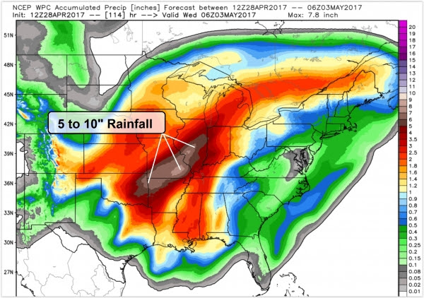
An atmospheric tug-of-war over the central USA may produce life-threatening flooding from the Ozarks into the Ohio Valley. Over 10 inches of rain may fall by Wednesday; a tropical storm's worth of moisture.
For the record, weather impacts about a third of America's GDP; roughly $6 TRILLION worth of economic activity is at the mercy of the elements. And there's mounting evidence that weather extremes are trending even more extreme over time.
Expect glimmers of sun and 50s today, the better day to mow the lawn or go for a walk. An impressive, almost March-like storm pushes a cold rain into town Sunday. The column of air overhead cools Monday as rain mixes with slushy snow. Lawns may get slushed up in the metro, but the best chance of plowable (3-inch-plus) amounts may set up from Alexandria to Bemidji, Brainerd and Hibbing.
The best part of a freak May snow? A higher sun angle should melt whatever falls within 24 hours.

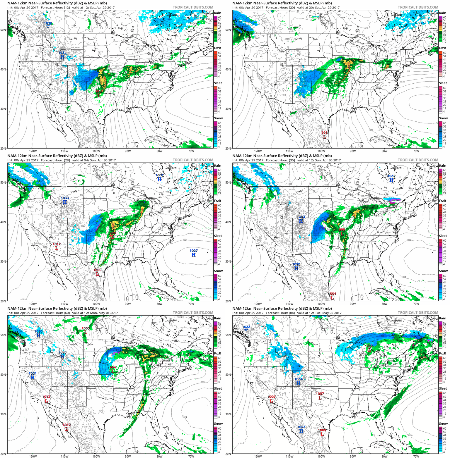
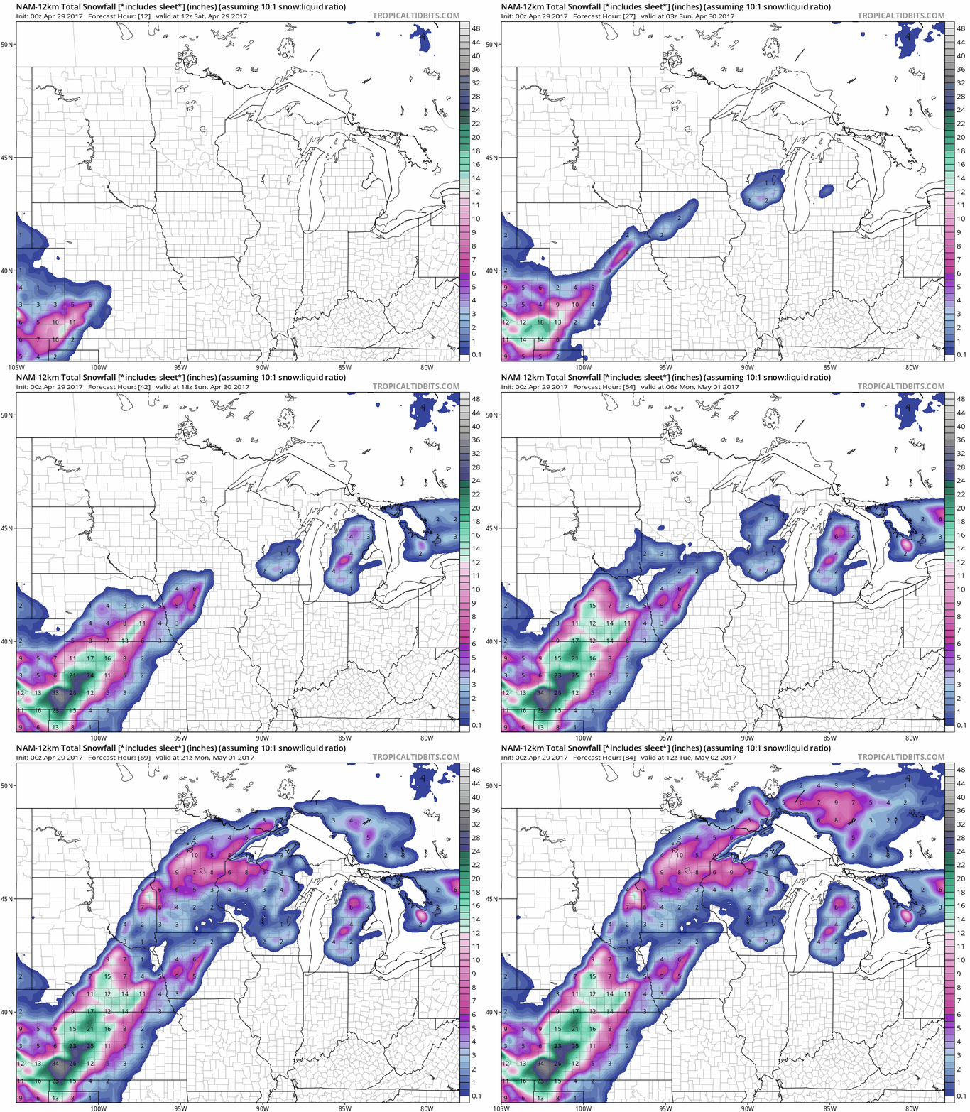
NAM Model Solution. The most extreme snowfall amounts are forecast to fall on southeastern Coloado and western Kansas, where some 2 foot amounts are predicted. Impressive for late April. The 12 KM NAM has the same general idea as the European, with the heaviest amounts of slush setting up north and west of the Twin Cities Monday and Monday night. Stay tuned. Make sure there's fresh Kodacolor film in your camera - nothing more enchanting than snow clinging to green tree branches! Ugh...
Animation credit: Tropicaltidbits.com
Historical May Snow Events in the Twin Cities. Yes, it may snow again late Sunday into Monday, May 1. Big gulp. Deep sigh. How unusual? The Minnesota DNR provides perspective: "...The most recent measureable Twin Cities snow event was 0.5 inches on May 3, 2013. About once every 30 years or so, there is a snow event that is enough to cover newly greened lawns and coat budding leaves. The last time there was a snow event in May greater than an inch in the Twin Cities was on May 2, 1976 with 1.2 inches. The most that it has snowed in May in a single event for the Twin Cities is three inches. This has happened on three occasions: May 20, 1892, May 1, 1935 and May 11-12, 1946."
Praedictix Severe Weather Briefing: Issued Friday afternoon, April 28, 2017.
* Two major weather risks unfolding over the next 48+ hours.
* Potential for life-threatening amounts of rain over the midsection of the USA into early next week, as waves of heavy showers and T-storms redevelop over the same saturated, waterlogged counties, from the Ozarks to the Ohio Valley. Some 10"+ rainfall amounts are possible, roughly a tropical storm's worth of rain.
* Other significant risk is heavy snow and sleet from Denver into the central Plains and Upper Midwest by Sunday and Monday. We may be sliding into May, but as far as the atmosphere is concerned it's still early March over the central USA.


Summary: the pattern remains extreme, and right now we are most concerned about 1). flooding rains and 2). heavy snowfall. The greatest risk to life and property will be river flooding and urban flooding over the central USA from a convergence of factors. Stay alert and listen to local authorities should evacuations become necessary. From Denver to Omaha and the Twin Cities (Sunday) the only saving grace will be the fact that this enormous slush-storm is coming on a weekend. More updates over the weekend as conditions warrant.
Paul Douglas, Senior Meteorologist, Praedictix

East Coast Braces for Record Heat. While residents from the Rockies to the Upper Midwest wrap their brains around more slushy snow in the forecast, the eastern USA will simmer on Saturay witih a string of record-breaking 80s and 90s. Serious weather-whiplash.
Why the Federal Flood Insurance Program is $24.6 Under Water. Here's an excerpt of an eye-opening update from Yahoo Finance: "...Despite repeated efforts to contain the cost of disaster response and encourage individuals and businesses to build outside of flood plains, government-subsidized insurance premiums haven’t kept up with the government’s risks. As a result, the Federal Emergency Management Administration (FEMA) – the manager of the program – has gone deeper and deeper into debt. Since 1996, federal debt incurred by the flood insurance program has increased 16-fold and has directly added to the national debt. As of last month, FEMA owed the Treasury $24.6 billion for money borrowed to pay claims that exceeded premiums collected, a new report by the Government Accountability Office (GAO) states. Those funds include $1.6 billion that FEMA borrowed following a series of floods in 2016. “FEMA is unlikely to collect enough in premiums to repay this debt,” GAO said in its report, the most recent in a series of critical reviews..."
Hurricane Hunter Aircraft Study Severe Thunderstorms and Tornadoes Too. An article at WHNT.com in Huntsville caught my eye: "...On
the ground, you are committed to a location and you just hope the
storms will come close to you. And so what we’re measuring with the
radars [on the airplane] is basically very similar things [compared to
radars on the ground]," Jorgensen states. “By using the aircraft, we can
get close and we can fly patterns that will enable us to do these
analysis and get the wind flow very accurately. And ground based radars
can do the same thing, but you gotta be lucky and have the storms go to
you," Jorgensen elaborated. And unlike ground-based single truck radars,
the P-3 is equipped with three separate radar systems, all used to
research storms from about a mile and a half above the ground..."
Photo credit: "Fuselage radar located under the WP-3D Orion." (Photo: WHNT News 19)
Named Storms: Forecast (11) - Average (12)
Hurricanes: Forecast (4) - Average (6-7)
Major Hurricanes: Forecast (2) - Average (2)
The reasoning behind the slightly below average hurricane forecast is due to the development of a weak to moderate El Nino likely developing in the Pacific Basin (According to NOAA). When an El Nino develops, wind shear in the middle and upper levels of the atmosphere increases in the Atlantic, which leads to less favorable weather conditions for tropical development there. There is also some assumption by forecasters that water temperatures in the Atlantic will be trending cooler than average this year, which will may also help to keep tropical formation lower..."
Graphic credit: "According to NOAA the U.S. has had about 100 more tornadoes than average so far in 2017, but that doesn't mean the rest of the year will follow the same trend." (NOAA)
Republicans and Democrats Agree On One Thing: Solar Panels. Here's a clip from Yale Climate Connections: "In Washington D.C., solar energy is sometimes seen as a political issue. But research suggests constituents – both Democrats and Republicans – feel differently. A solar consulting company called PowerScout pulled the addresses of one-and-a-half million political donors. Then, they used satellite images to identify which of their homes had solar panels. Attila Toth is CEO and Founder of PowerScout. Toth: “Across the twenty states that we looked at, Democratic and Republican party donors installed residential solar systems at very comparable rates...”
Why We Can't Just Leave Environmental Protection to the States. That's the funny thing about pollution - it doesn't respect state boundaries. Here's an excerpt at Grist: "...First, states often don’t enforce the laws within their own borders when the people primarily harmed live downwind or downriver in another state. States don’t want to spend their money or their political capital to benefit other states. The federal government has the responsibility to protect everyone — like the millions of people on the East Coast who suffer the effects from large air polluters in the Midwest. Second, many significant violators are national companies that operate in many states. Individual states can’t effectively take on nationwide operations. Filing cases one state at a time is inefficient and leads to inconsistent results..."
File photo: Gene Daniels, U.S. National Archives.
Flexible Working is Making Us Work Longer. Really? Here's a story at Quartz highlighting new research: "...Contrary to what you might expect, those with more control over their work schedule work more than those with less control. In fact, people have a tendency to work more overtime hours once they are allowed to work flexibly, compared to when they were not. These were the findings of research my colleague Yvonne Lott and I recently carried out, published in the European Sociological Review. We examined data that followed workers across a number of years in Germany to see what happened to the amount of overtime they did once they started having more control over their working hours..."
Photo credit: Anil Seth speaks at TED2017Marla Aufmuth/TED.
Science Has Outgrown the Human Mind and Its Limited Capacities. Will really smart computers be pushing science forward in years to come - will AI (artificial intelligence) be making the big discoveries? Here's an excerpt from Aeon Ideas: "Science is in the midst of a data crisis. Last year, there were more than 1.2 million new papers published in the biomedical sciences alone, bringing the total number of peer-reviewed biomedical papers to over 26 million. However, the average scientist reads only about 250 papers a year. Meanwhile, the quality of the scientific literature has been in decline. Some recent studies found that the majority of biomedical papers were irreproducible. The twin challenges of too much quantity and too little quality are rooted in the finite neurological capacity of the human mind. Scientists are deriving hypotheses from a smaller and smaller fraction of our collective knowledge and consequently, more and more, asking the wrong questions, or asking ones that have already been answered..."
Image credit: Future of Life Institute.
TODAY: Some sun, a dry sky - nicer day of the weekend. Winds: NE 10-15. High: 55
SATURDAY NIGHT: Clouds thicken, rain by daybreak. Low: 38
SUNDAY: A cold, windswept rain. Winds: NE 15-30. High: 43
MONDAY: Wintry mix of rain and snow. Slushy lawns MSP metro? Winds: N 10-20. Wake-up: 37. High: 41
TUESDAY: Lingering clouds and sprinkles. Winds: NW 10-15. Wake-up: 35. High: 49
WEDNESDAY: Partly sunny, risk of spring. Winds: SE 5-10. Wake-up: 39. High: near 60
THURSDAY: Unsettled, few showers around. Winds: NW 10-15. Wake-up: 46. High: 57
FRIDAY: Blue sky returns, milder. Winds: NE 7-12. Wake-up: 45. High: 63
Climate Stories....
Graphic credit: "Trends in global temperatures, using a a change-point analysis for five different data sets. Illustration: Rahmstorf et al. (2017), Environmental Research Letters."
Photo credit: "Mercy Sisters joined an estimated 310,000 demonstrators in the People's Climate March in New York Sept. 21, 2014." CNS photo/Jim West.

Linking Extreme Weather Events To Our Changing Climate. How strong is the case for attribution? Correlations are very high for extreme heat events, followed by a tendency for heavier rain events and intense floods. Here's an excerpt of an interview with a climate scientist at Standford University at Michigan Radio: "...What is new in this paper we have out this week is we’ve taken a look across the globe at multiple different kinds of extreme events: hot, wet, dry,” he explains. And they looked at whether specific record-setting events were influenced by the global warming that’s already happened. “What we find is that the hottest events have been made more likely by global warming at more than 80% of the area we’ve been able to look at,” he says. He says climate change has increased the odds for the wettest and driest events in about half the places they looked."
Climate Change Altering the Arctic Faster Than Expected. Climate Central has the latest: "Evidence continues to mount that climate change has pushed the Arctic into a new state. Skyrocketing temperatures are altering the essence of the region, melting ice on land and sea, driving more intense wildfires, altering ocean circulation and dissolving permafrost. A new report chronicles all these changes and warns that even if the world manages to keep global warming below the targeted 2°C threshold, some of the shifts could be permanent. Among the most harrowing are the disappearance of sea ice by the 2030s and more land ice melt than previously thought, pushing seas to more extreme heights. The findings, released Monday in the Snow, Water, Ice and Permafrost in the Arctic (SWIPA) assessment, come after a winter of extreme discontent for the region. Sea ice receded a bit in November, a rare occurrence, and hit a record-low maximum for the third year in a row. Temperatures averaged 11°F above normal, driven by sustained mild weather that was punctured by periods of almost unheard of heat when temperatures reached up to 50°F above normal..."
Photo credit: "An iceberg collapses, Disko Bay, West Greenland." Credit: Carsten Egevang/arc-pic.com.
Photo credit: "The March for Science in Washington DC. Members of the caucus say their goal is to depoliticize environmental policy in the US." Photograph: Jim Lo Scalzo/EPA
Worrisome Figures For Canadian Methane. Climate Nexus has a collection of media reports on methane releases to our north: "Methane emissions from the oil and gas industry in Canada could far exceed official estimates, according to two new reports. A new study from the David Suzuki Foundation and St. Francis Xavier University published in the journal Atmospheric Chemistry and Physics finds methane emissions from industry activity in British Columbia could be 2.5 times higher than previous estimates. Meanwhile, a separate report released from a Canadian nonprofit today estimates that methane emissions in Alberta could be up to 60 percent higher than official figures. The Canadian government announced last week that it would delay planned methane reduction regulations by up to three years, garnering fierce criticism from environmental advocates." (Studies: Toronto Star, Motherboard, Vancouver Sun, Globe and Mail. Regulation delay: CBC, Toronto Star).
Image credit: Environmental Defense Fund.
The Policy Weapon Climate Activists Need. Buy out the fossil fuel companies to keep carbon in the ground? A nice idea, but probably a fairy-tale. Here's a clip from The Nation: "...The most straightforward way to accomplish this is for the government to take direct ownership of fossil-fuel companies. The price tag to purchase outright the top 25 largest US-based publicly traded oil and gas companies, along with most of the remaining publicly traded coal companies, is in the region of $1.15 trillion. That sounds like a lot of money, but spread out over seven years, the cost would be less than $200 billion a year, a far from impossible amount—and less than the annual cost of our string of recent wars. By way of comparison, paying for the wars in Iraq and Afghanistan will have cost somewhere in the range of $4-7 trillion when future costs for veterans are factored in. Surely, radically reducing the threat of climate catastrophe is a better use of the US government’s financial power than was the disastrous invasion of Iraq..."
Photo credit: "A coal-fired power plant in Holcomb, Kansas, in 2007." (AP Photo / Charlie Riedel).
No comments:
Post a Comment