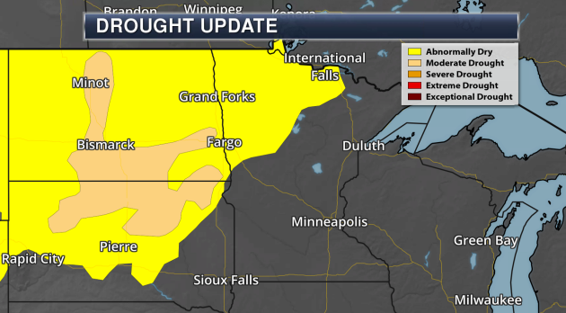
"Abnormally Dry" Conditions Across Northwest Minnesota
______________________________
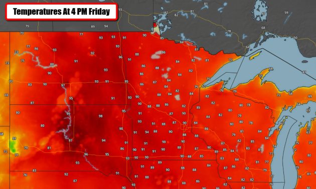
First 90 Of 2017 Friday
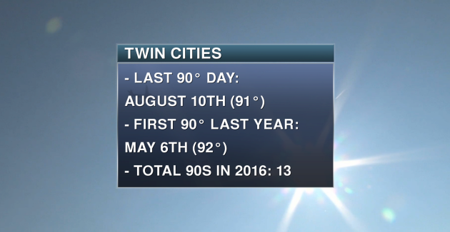
This first 90 of the year is right around average. Typically we see our first 90 either on June 10th (if you look at the entire record for the Twin Cities) or June 2nd (if you look at the 1981-2010 climatological 30-year period), so either way it has occurred when would expect it. Meanwhile, this type of weather makes me want to sit in front of my air conditioner all day... I'm personally not a fan of this heat.
______________________________
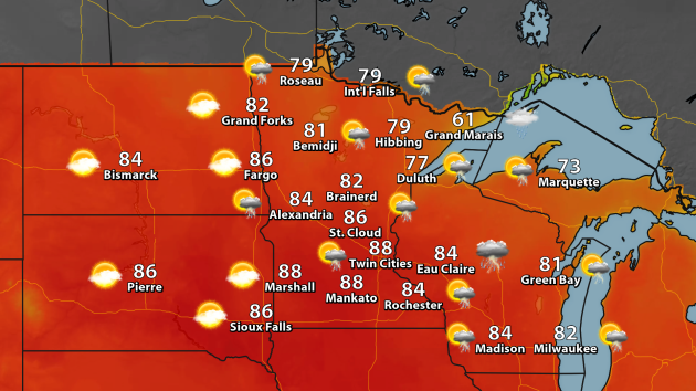
Approaching 90 Today - Cooler Weather For Sunday
By DJ Kayser, filling in for Paul Douglas
By DJ Kayser, filling in for Paul Douglas
Have you turned on your air conditioning yet?
It's like Mother Nature knew as soon as June came around to throw open the windows and let the heat and
humidity quickly flow right back into Minnesota. Highs will approach 90 once again today across southern Minnesota, and with dewpoints in the 60s we will certainly get our first real taste of summer weather.
humidity quickly flow right back into Minnesota. Highs will approach 90 once again today across southern Minnesota, and with dewpoints in the 60s we will certainly get our first real taste of summer weather.
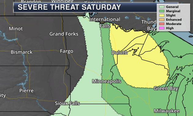
How warm we get today, though, all depends on how fast a cold front moves across the state. That front could spark off a few stronger storms this afternoon, but if it holds off long enough I could see us getting within a few degrees of the record of 92.
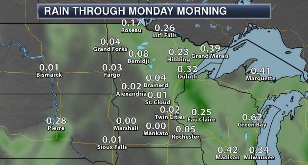
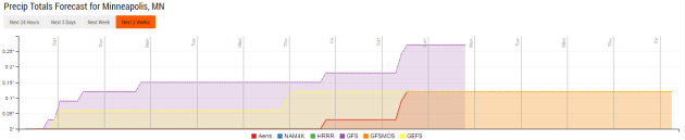
Cooler weather will filter in behind the front to end the weekend and begin next week, with highs returning to the 70s and low 80s. There is an isolated storm chance during the afternoon hours Sunday, but it will be a much more pleasant day across the region for outdoor activities.
In other words, the heat and humidity today will just be a sneak peek of what’s to come later this summer.
______________________________
Extended Forecast for Minneapolis
SATURDAY: Hot & sticky. Some afternoon storms - a few could be strong. High 89. Low 62. Chance of precipitation 30%. Wind SW 5-10 mph.
SUNDAY: Cooler with some isolated afternoon storms. High 82. Low 58. Chance of precipitation 20%. Wind W 5-10 mph.
MONDAY: Nice day expected. High 78. Low 57. Chance of precipitation 0%. Wind NE 5-10 mph.
TUESDAY: Sunny start. A few afternoon clouds. High 78. Low 58. Chance of precipitation 0%. Wind SE 3-5 mph.
WEDNESDAY: A few scattered showers. High 79. Low 59. Chance of precipitation 20%. Wind SW 5-10 mph.
THURSDAY: Lingering showers. A touch cooler. High 75. Low 58. Chance of precipitation 20%. Wind NW 5-10 mph.
FRIDAY: Warming trend starts again. High 77. Low 57. Chance of precipitation 10%. Wind S 5-10 mph.
______________________________
This Day in Weather History
June 3rd
June 3rd
1955: Seven people are killed on Lake Traverse when their boat is overturned by strong winds from a thunderstorm.
______________________________
Average Temperatures & Precipitation for Minneapolis
June 3rd
June 3rd
Average High: 75F (Record: 92F set in 1923)
Average Low: 55F (Record: 34F set in 1945)
Average Precipitation: 0.13" (Record: 1.71" set in 1914)
______________________________
Average Low: 55F (Record: 34F set in 1945)
Average Precipitation: 0.13" (Record: 1.71" set in 1914)
______________________________
Sunrise/Sunset Times for Minneapolis
June 3rd
June 3rd
Sunrise: 5:28 AM
Sunset: 8:54 PM
Sunset: 8:54 PM
*Length Of Day: 15 hours, 25 minutes and 47 seconds
*Daylight Added Since Yesterday: ~1 minutes and 16 seconds
*Earliest Twin Cities Sunrise During The Year: June 13th-17th (5:25 AM)
*Next Sunset At/After 9 PM: June 12th (9:00 PM)
*Daylight Added Since Yesterday: ~1 minutes and 16 seconds
*Earliest Twin Cities Sunrise During The Year: June 13th-17th (5:25 AM)
*Next Sunset At/After 9 PM: June 12th (9:00 PM)
______________________________
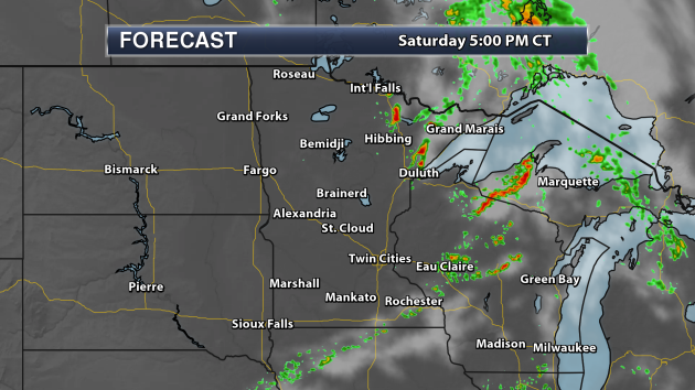
Minnesota Weather Outlook
______________________________
National Weather Outlook
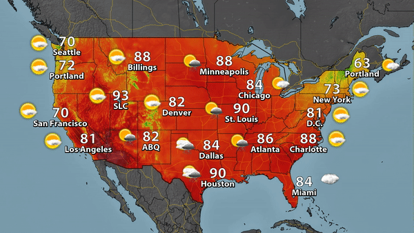
Saturday Forecast
______________________________
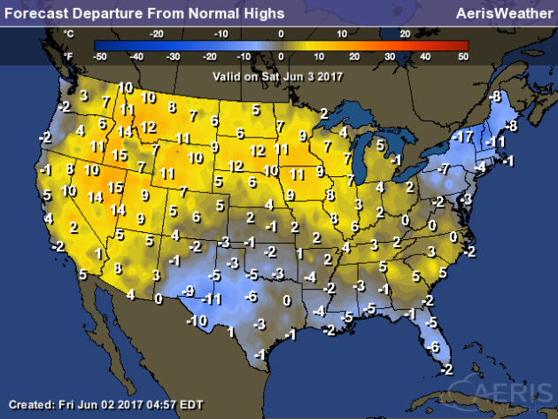
What Could The Summer Hold?
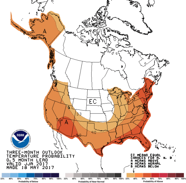
As
we head into the summer months (June through August), the Climate
Prediction Center is calling for the potential of above average
temperatures across a good portion of the lower 48 and across all of
Alaska. The best chance of seeing near-normal temperatures looks to be
across parts of the upper Midwest and the Central and Northern Plains.
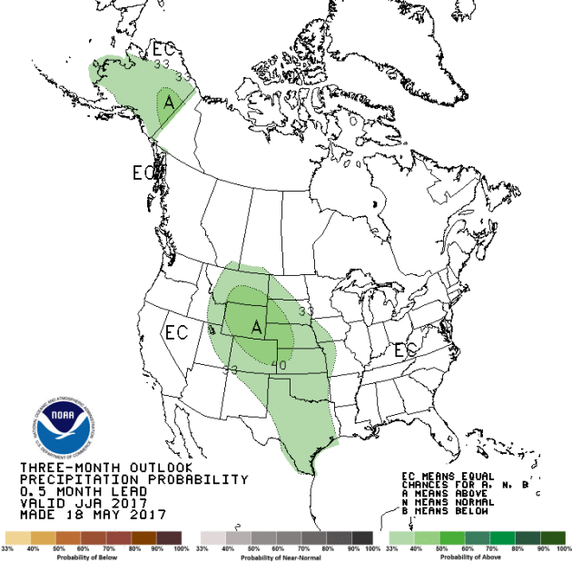
Meanwhile, the Climate Prediction Center is calling for the potential of above average precipitation
across portions of the central U.S. into the Rockies, from Montana and
North Dakota south into Texas between June and August. Above average
precipitation is also possible across a good portion of Alaska.
Beginning Of The Atlantic Tropical Season
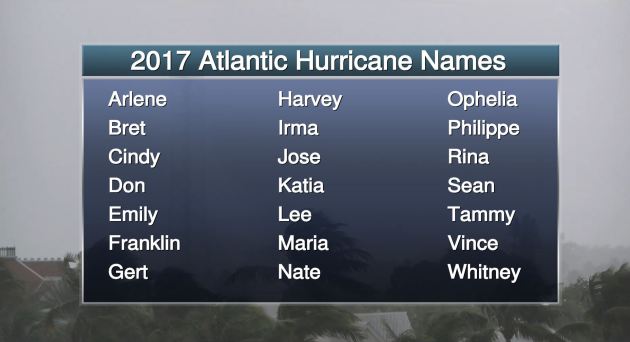
While
we already had our first named storm back in April, Thursday marked the
official start of the of the 2017 Atlantic tropical season. Above is
the list of names for the season, from Arlene to Whitney.
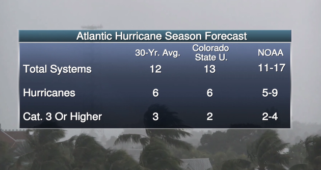
The
tropical season forecast from various agencies are showing the
potential of an above average season in the Atlantic. The NOAA forecast
released last week shows a forecast of 11-17 named systems. Meanwhile,
the Colorado State University forecast was just updated Thursday and
shows a forecast of 13 named systems, which is up from the 11 systems
they had in the forecast in April.
No One In The Trump Administration Wants To Talk Climate Change
Did you listen to Trump's speech withdrawing
the U.S. from the Paris climate agreement from Wednesday? Notice how he
didn't mention anything about climate change in it? CNN noticed: "The
pattern of the White House has been to turn away from the discussion of
climate change without taking the step to argue directly that global
warming isn't real. Instead, there is an administration-wide reluctance
to avoid the topic altogether."
Fact Checking Trump's Climate Speech
The Washington Post took some time to fact check President Trump's speech. It is certainly worth a read - here is just the first paragraph: "In
his speech announcing his decision to withdraw from the Paris Accord on
climate change, President Trump frequently relied on dubious facts and
unbalanced claims to make his case that the agreement would hurt the
U.S. economy. Notably, he only looked at one side of the scale —
claiming the agreement left the United States at a competitive
disadvantage, harming U.S. industries. But he often ignored the benefits
that could come from tackling climate change, including potential green
jobs."
Minnesota Just One State Fighting Climate Change On Their Own
The good news is that states and cities are still going on their own to fight climate change. Minnesota is one of those states. More from the Star Tribune: "With
a plan adopted in 2007, the state has been a national leader in
pursuing an aggressive plan to reduce emissions of the chemicals that
cause climate change. And though Minnesota has missed its targets in
recent years, President Trump’s controversial decision to pull the
United States out of the global climate deal struck last year won’t
change what has been slow and steady progress, state environmental
officials said Thursday."
Two Other Countries Not In The Paris Agreement
There
are two other countries that are not part of the Paris climate
agreement: Syria and Nicaragua. While the circumstances in Syria are
likely clear, Nicaragua stands out because they felt the agreement
doesn't do enough. More on that from Slate: "Nicaragua’s
Paul Oquist, who represented the country at the Paris negotiations in
2015, has said that Nicaragua’s main problem with the Paris Agreement is
that countries’ pledges to fight climate change—known as “intended
national determined contributions”—are voluntary. Oquist says that
because the commitments aren’t binding, the climate change agreement
will fail to meet its goal."
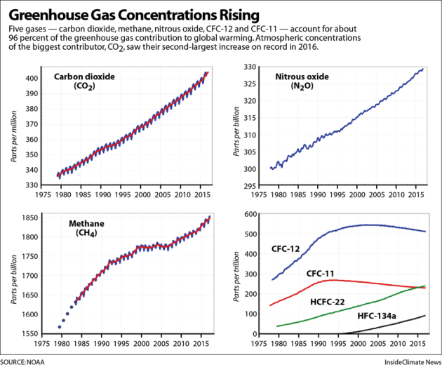
Global Greenhouse Gases Increase In 2016... Again
Just
because President Trump has pulled out of the Paris climate agreement
certainly doesn't mean that climate reporting will stop. NOAA is
reporting that carbon dioxide had its second largest jump on record in
2016. More from Inside Climate News: "Concentrations
of other greenhouse gases, including methane and nitrous oxide, also
increased last year, according to the National Oceanic and Atmospheric
Administration's latest update to its greenhouse gas index. The heating
effect of all combined greenhouses gases in the atmosphere increased by
2.5 percent in 2016, according to the index."
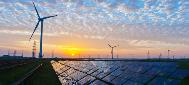
10.1% Of U.S. Electricity From Solar And Wind In March
Led
by California and Iowa, solar and wind energy for the first time
supplied over 10% of the electricity used in the U.S. during the month
of March according to the U.S. Department of Energy’s Electricity
Information Administration. More from PV Magazine: "EIA’s
latest edition of Electric Power Monthly shows that during March wind
and solar together met 10.1% of U.S. electricity demand. This the first
time that these two sources combined have ever met more than 10% of
power, a fact which was first reported in the TerraJoule newsletter."
______________________________
Thanks for checking in and have a great Saturday! Don't forget to follow me on Twitter (@dkayserwx) and like me on Facebook (Meteorologist D.J. Kayser)!
- D.J. Kayser

No comments:
Post a Comment