A Very Wet May In The Twin Cities
It
was a wet May across the Twin Cities. Overall, we saw fourteen total
days with measurable (0.01"+) precipitation, which tied for the fifth
most days in May with measurable precipitation on record. The most was
just a few years ago in 2013 when we saw 18 days with measurable
precipitation.
The
day that saw the most rain was back on May 17th when 1.81" fell setting
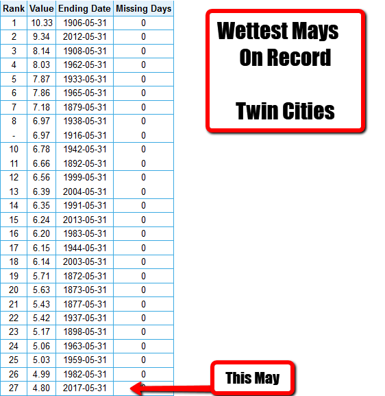
a new record for the day. Overall, we saw 4.80" of rain last month,
which ended up being the 27th wettest May on record for the Twin Cities.
We have started off the month of June with a little less precipitation,
but when could we see more? More on that in a moment.
______________________________
The Warm Streak Ends
______________________________
Cooler Weather Monday - Not Many Rain Chances
By D.J. Kayser, filling in for Paul Douglas
By D.J. Kayser, filling in for Paul Douglas
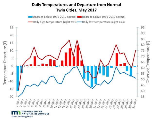
For the most part, June has started off warm and dry - quite the opposite of what May was here in the Twin Cities.
May
2017 will go down in the record books as the twenty-seventh wettest May
on record in the Twin Cities, with 4.80" of rain falling over fourteen
separate days. Those rainy days helped us break the streak for the most
consecutive months with an above average temperature at twenty, as the
month ended 0.6 degrees below average.
The
drier pattern we've witnessed to begin the month will continue for the
most part this week across the region. The main chance during the work
week of seeing any rain will be Thursday,
and even that has numerous factors working against it. Highs will be
back in the 70s to low 80s, slightly above average for this time of
year.
A
pattern shift will occur as we head into next weekend, bringing warmer
and more humid air back into the picture. Rain chances could exist here
as well, and is something we'll have an eye on over the next several
days.
Until then, enjoy the cooler weather!
______________________________
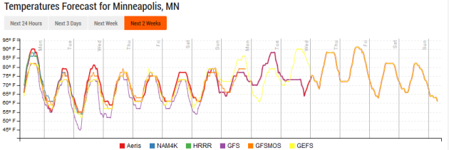
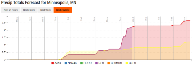
Extended Forecast for Minneapolis
MONDAY: Sunny. More comfortable. High 79. Low 54. Chance of precipitation 0%. Wind NE 5-10 mph.
TUESDAY: Sunny skies. Highs slightly above average. High 80. Low 57. Chance of precipitation 0%. Wind NE 3-5 mph.
WEDNESDAY: A few more clouds. High 80. Low 60. Chance of precipitation 10%. Wind S 3-5 mph.
THURSDAY: Chance of a few showers and storms. High 78. Low 58. Chance of precipitation 30%. Wind SW 5-10 mph.
FRIDAY: Mix of clouds and sun. High 79. Low 59. Chance of precipitation 10%. Wind NW 5-10 mph.
SATURDAY: A little warmer. Mainly sunny skies. High 82. Low 64. Chance of precipitation 10%. Wind SE 5-10 mph.
SUNDAY: Clouds return. Stronger southwest wind. High 82. Low 62. Chance of precipitation 20%. Wind SW 10-15 mph.
______________________________
This Day in Weather History
June 5th
June 5th
1930: Heavy rain falls at Waseca. 4.3 inches of rain would fall over 24 hours.
1915:
This date marks the first of a long stretch of days of measurable rain
at Winton near Ely. Measurable rain would fall on each day until 19th.
The total amount of rain for the fifteen days was over six inches.
______________________________
Average Temperatures & Precipitation for Minneapolis
June 5th
June 5th
Average High: 76F (Record: 92F set in 1925)
Average Low: 55F (Record: 40F set in 2000)
Average Precipitation: 0.13" (Record: 2.53" set in 1980)
______________________________
Average Low: 55F (Record: 40F set in 2000)
Average Precipitation: 0.13" (Record: 2.53" set in 1980)
______________________________
Sunrise/Sunset Times for Minneapolis
June 5th
June 5th
Sunrise: 5:27 AM
Sunset: 8:55 PM
Sunset: 8:55 PM
*Length Of Day: 15 hours, 28 minutes and 8 seconds
*Daylight Added Since Yesterday: ~1 minutes and 8 seconds
*Earliest Twin Cities Sunrise During The Year: June 13th-17th (5:25 AM)
*Next Sunset At/After 9 PM: June 12th (9:00 PM)
*Daylight Added Since Yesterday: ~1 minutes and 8 seconds
*Earliest Twin Cities Sunrise During The Year: June 13th-17th (5:25 AM)
*Next Sunset At/After 9 PM: June 12th (9:00 PM)
______________________________
Minnesota Weather Outlook
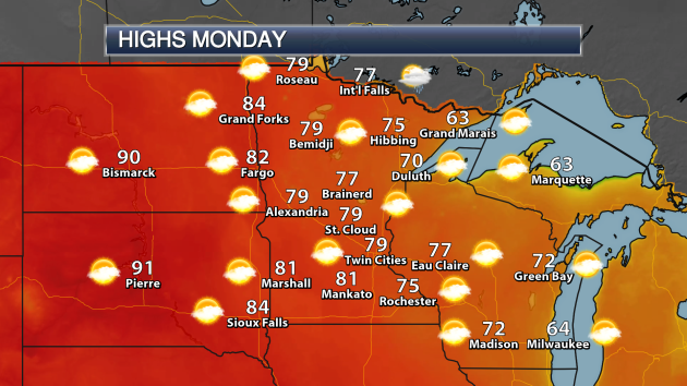
We
will see a cooler day across the state today, with the warmest weather
expected out to the west. While areas like Marshall, Mankato and Fargo
will reach the 80s for highs, most of us will be stuck in the 70s.
Again, though, if you want it cooler, Duluth and Grand Marais will be
the spots to hit!
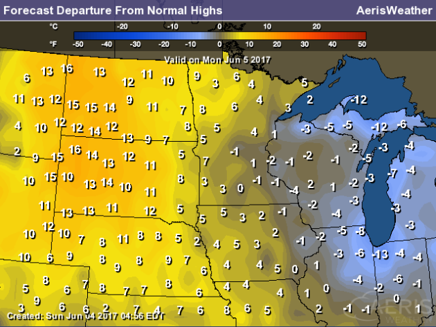
Highs
will be a lot closer to average Monday across most of the state. You'll
have to head out to west-central or northwest Minnesota to see
departure from average highs that are 5-10 degrees above average.
We'll
continue to see highs that stick right around 80 for the work week here
in the Twin Cities. We do see a slight warm up as we head into next
weekend and particularly next week, with highs potentially pushing 90
again by next Monday or Tuesday.
Precipitation
chances won't be the greatest across the region this week as well. Here
in the Twin Cities we'll have a rain chance as we head into Thursday,
however that doesn't look promising with many factors helping to damper
that potential. Another chance could exist as we head into the weekend,
but we'll have to watch capping of the atmosphere that could prevent
storms from forming. After that, it looks like another chance could work
in as we head toward the middle of the month.
______________________________
National Weather Outlook
Monday Forecast
We'll
watch the chances of widespread rain from Albuquerque to the Northeast
on Monday. Highs will be cooler than they were this weekend, however,
across parts of the upper Midwest and into Salt Lake City as well. The
cool weather continues in the Northeast, however, as highs only make it
into the mid 50s in Portland, ME.
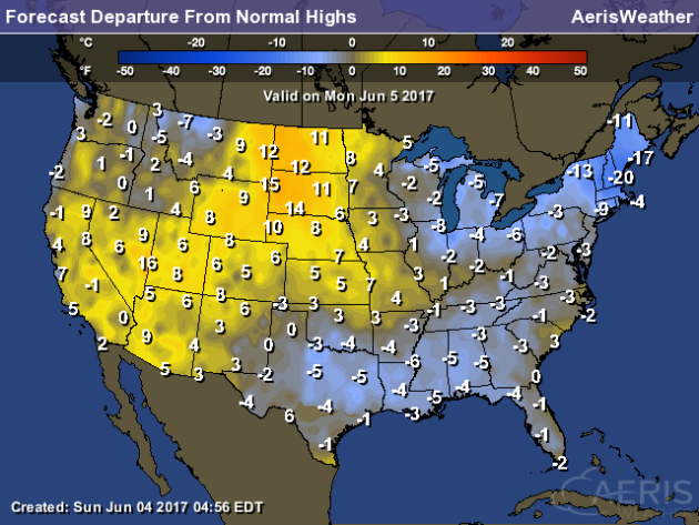
The
greatest departure from averages (on the warm side) will be from the
Desert Southwest to the Northern Plains, where highs are expected to be a
good 5-15 degrees above average. It'll be a chilly day, however, in the
Northeast, where highs could be up to 20 degrees below average.
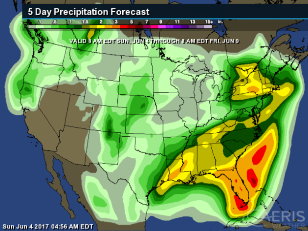
The
heaviest precipitation through Friday morning will be across the Gulf
Coast states, where 2-4"+ of rain is possible due to a slow moving
system and lots of available moisture from the Gulf of Mexico. Heavier
precipitation - on the order of 1-3" - is possible as well across the
Northeast.

As
we take a look at rain totals through Wednesday morning in the South
Central U.S., the greatest amounts are expected in the eastern part of
the region, with over 2" of rain possible for areas like New Orleans.
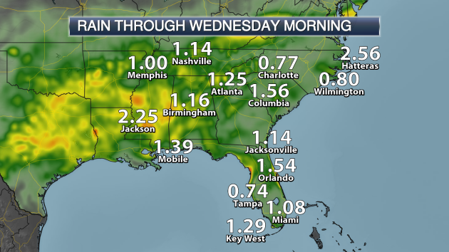
Shifting
to the Southeast, a widespread swath of 1-3" is possible from Memphis
and Jackson through Atlanta and south into Florida.
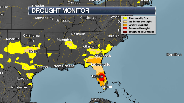
This
rain will be good news to parts of the Southeast, especially areas of
Florida and southern Georgia, which are currently dealing with drought
conditions. About 15% of the state of Florida is currently under extreme
drought, with abnormally dry (or higher) conditions covering
approximately 83% of the state.
______________________________
"I Was Keeping An Eye On It"
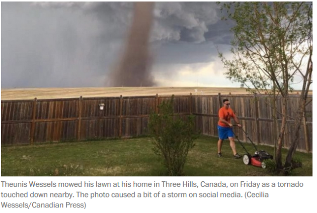
Yes,
those are the exact words of the guy that was mowing his lawn in the
viral photo of the tornado near Three Hills, Canada Friday. More from the Washington Post: "(Cecilia)
Wessels told the Canadian Press that mowing the lawn was on her
husband’s to-do list. With her husband doing his chores, Wessels decided
to take a nap. She told the Press that when her daughter woke her up a
short time later, the 9-year-old was upset. There was something in the
sky that resembled a tornado, the little girl said, but her father was
refusing to come indoors." (Screenshot from the Washington Post article)
National Weather Service Employees "Fatigued" And "Demoralized"
"Fatigued"
and "demoralized" - not two words that I want to hear connected with
the people that keep us safe by issuing watches and warnings for
inclement weather. But, it's something you can thank government
bureaucracy for (what's new there). More from Angela Fritz at the Capital Weather Gang: "The
employees of the National Weather Service are demoralized, according to
a recent report by the Government Accountability Office. They are
understaffed and spread thin, covering shifts and positions beyond what
they were hired to fill. The weather never sleeps, and apparently
neither does the Weather Service."
A Look Back At May
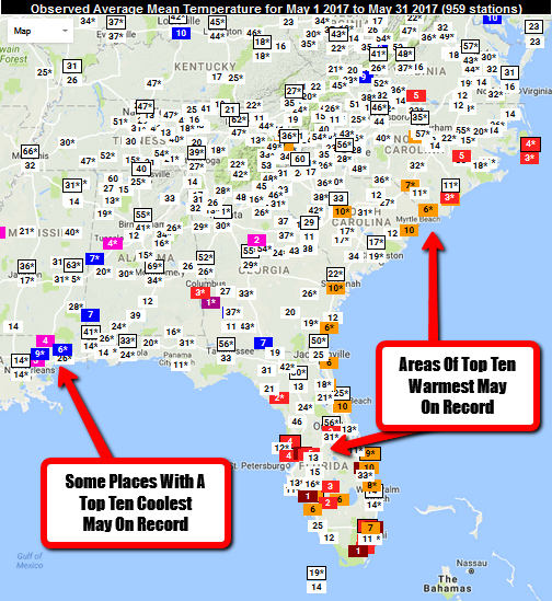
The
Southeast was quite interesting during the month of May. Areas from
southern Virginia to Florida saw one of their warmest months of May on
record, including Tampa (FL) and Cape Hatteras (NC). However, as you
went west, some areas around the New Orleans area saw one of their
coolest. New Orleans officially saw their 14th coolest May on record,
according to the data from the Southeast Regional Climate Center.
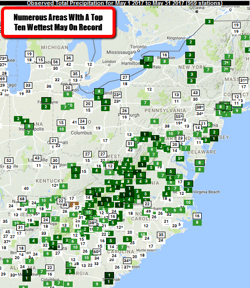
Meanwhile
it was a very wet May out east as well, with many areas seeing a top
ten wettest May on record. At least two major cities saw their wettest
May on record - Savannah, GA (11.54") and Montgomery, AL (12.74").
Awesome Storm Timelapses In 4k

Want to watch spectacular storm footage in 4k? Chad Cowan with StormLapse placed a video up recently on viemo you can check out here.
This is some of the most gorgeous shots of weather I have seen and is
worth your time... even if you are watching it on a phone.
______________________________
Thanks for checking in and have a great Monday! Don't forget to follow me on Twitter (@dkayserwx) and like me on Facebook (Meteorologist D.J. Kayser)!
- D.J. Kayser

No comments:
Post a Comment