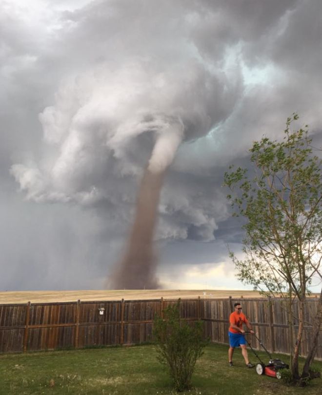
"Canada tornado: Alberta lawn-mowing man defies twister"
"A picture of a man in Canada calmly mowing his lawn with a menacing tornado swirling in the background has gone viral on social media. Theunis Wessels was "fully aware" of the twister but "wasn't worried at all", his wife Cecilia, who took the photo, told the BBC. She said the tornado was about 2km (1.25 miles) from their house in Three Hills, Alberta - much further away than it appeared in the photo. The storm was quickly gone, she added. Mrs Wessels told the BBC she was sleeping in the house on Friday - but then was woken by her nine-year-old daughter who was concerned that her father would not abandon his lawn-mowing and hide inside from the tornado."
See more from BBC HERE:
See more from BBC HERE:
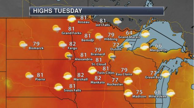
Weather Outlook For Tuesday
Tuesday will be another mild day across the region with highs in the upper 70s and lower 80s. Note that much of the day will be sunny and dry, but there could be a few late day showers and storms across far western Minnesota.
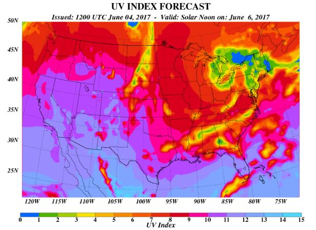
UV Index for Tuesday - VERY HIGH
The UV Index will be considered VERY HIGH across much of the state of Minnesota on Tuesday, which means that it will only 15 to 20 minutes or less to burn unprotected skin. With that said, if you are planning on spending any extended length of time outside, make sure you wear appropriate attire and lather on the sun block!
_____________________________________________________________
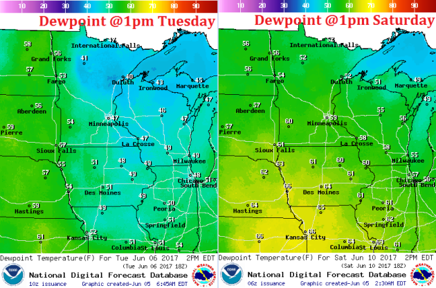
Increasing Dewpoints by the Weekend
Here's a look at dewpoints on Tuesday vs Saturday across the region. Note that dewpoints on Tuesday will generally be in the 40s (considered very comfortable), while dewpoints on Saturday will be a little higher and near 60F midday.
Weather Outlook
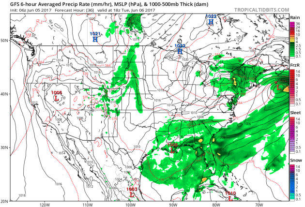
A storm system will churn along the Gulf Coast Region through midweek, which will allow widely scattered showers and thunderstorms to develop in the Southeastern US. Spotty strong to severe storms and locally heavy rainfall will be possible in some locations there. This heavy rain chance is great news for a few folks in Florida that are still dealing with drought!
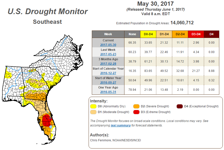
Drought in the Southeast
According to the US Drought Monitor, parts of Florida are still in an Extreme Drought. There has a little improvement since last week, but the more noticeable improvement has been since the beginning of the year, when nearly 21% of the Southeast was considered in an Extreme Drought and nearly 9% was in Exceptional Drought.
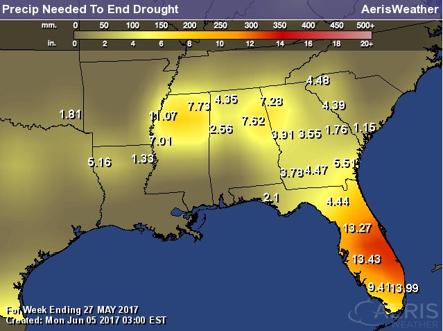
Precipitation Needed to End Drought
Here's a look at how much rainfall is needed to end the drought in the Southeast. Note that some locations across central and southern Florida will need nearly a foot of rain to end the very dry conditions there.
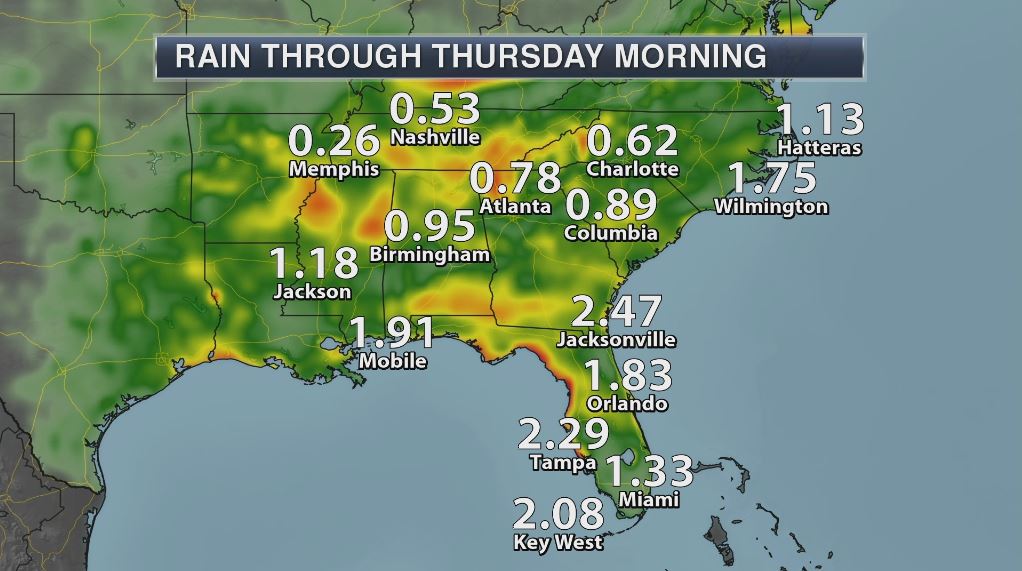
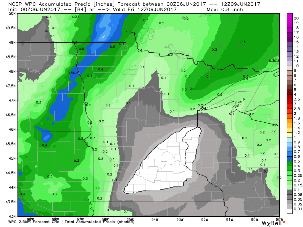
Rainfall Potential Through AM Thursday
The rainfall potential across through Southeast looks fairly impressive through Thursday morning. Several locations could see 1" to 2" while a few locations could see up to 3" to 5" by the end of the week.
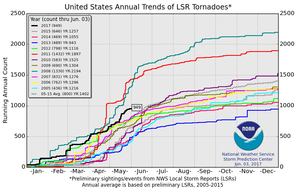
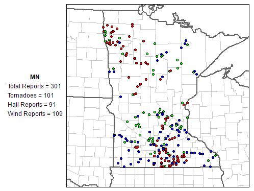
PRELIMINARY 2017 Tornado Count
According to NOAA's SPC, the PRELIMINARY 2017 tornado count is 949 (through June 3). Note that is the most active year for tornadoes since 2011, when there were nearly 1,400 tornadoes. Keep in mind there was a major tornado outbreak in the Gulf Coast region from April 25-28, 2011 that spawned nearly 500 tornadoes, some of which were deadly. That outbreak is known as the Super Outbreak of 2011 and has gone down in history as one of the biggest, costliest and one of the deadliest tornado outbreaks in history.
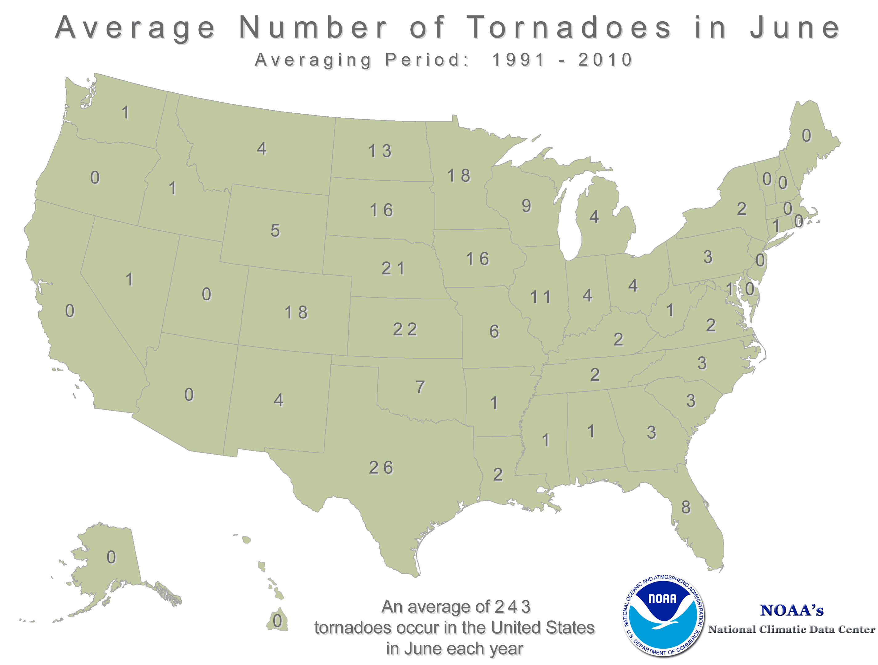
 According to NOAA's NCDC, June is the 2nd busiest month for tornadoes behind May across the country, averaging 243! Note that most of these tornadoes occur across the Plains from Texas to Nebraska, which is also in a region known as "Tornado Alley". As it stands now, May was the busiest tornado month of the year thus far with a preliminary total of 278.
___________________________________________________________________
Minnesota Tornadoes in 2016
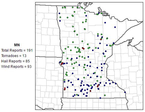
While June is typically the busiest month of the year for tornadoes in the state of Minnesota (averaging 18), there were only 13 tornadoes in June last year. However, there were nearly 200 severe weather reports.
Severe Weather Reports in 2010
The last time June had an above average tornado month was in 2010 when there were nearly 100 tornadoes reported. On June 17th, there were three EF-4 tornadoes and four EF-3 tornadoes, 3 of which were deadly!
________________________________________________________________________
Mostly Dry Ahead. Another Hot Front This Weekend
By Todd Nelson, filling in for Douglas
Well that escalated quickly... I left for the weekend and came back to a brown lawn and my garden screaming for water. Thanks to three consecutive days with highs in the 90s, we went from cool, lush-green lawns to crunchy brown lawns in a matter of days. By the way, the last time the Twin Cities hit 90 degrees or warmer three consecutive days was July 20-22 last summer, when the mercury hit 93F, 95F and 97F respectively.
Lawns and gardens will thank you for the continuous watering attention this week. Our only real shot at rain comes by way of spotty thundershower activity late Wednesday into Thursday. Despite still being nearly 1.5 inches above average in the precipitation department this year, it's getting dry fast!
Extended forecasts suggest another hot front arriving this weekend with highs near 90 degrees and dewpoints in the 60s. This could also prompt a round of strong storms close to home. Note that June averages 18 tornadoes in the state of MN, more than any other month. 2016 had 13 June tornadoes, while 2010 saw 101. WOW!
_______________________________________________________
Average Tornadoes in June
___________________________________________________________________
Minnesota Tornadoes in 2016
While June is typically the busiest month of the year for tornadoes in the state of Minnesota (averaging 18), there were only 13 tornadoes in June last year. However, there were nearly 200 severe weather reports.
Severe Weather Reports in 2010
The last time June had an above average tornado month was in 2010 when there were nearly 100 tornadoes reported. On June 17th, there were three EF-4 tornadoes and four EF-3 tornadoes, 3 of which were deadly!
________________________________________________________________________
Mostly Dry Ahead. Another Hot Front This Weekend
By Todd Nelson, filling in for Douglas
Well that escalated quickly... I left for the weekend and came back to a brown lawn and my garden screaming for water. Thanks to three consecutive days with highs in the 90s, we went from cool, lush-green lawns to crunchy brown lawns in a matter of days. By the way, the last time the Twin Cities hit 90 degrees or warmer three consecutive days was July 20-22 last summer, when the mercury hit 93F, 95F and 97F respectively.
Lawns and gardens will thank you for the continuous watering attention this week. Our only real shot at rain comes by way of spotty thundershower activity late Wednesday into Thursday. Despite still being nearly 1.5 inches above average in the precipitation department this year, it's getting dry fast!
Extended forecasts suggest another hot front arriving this weekend with highs near 90 degrees and dewpoints in the 60s. This could also prompt a round of strong storms close to home. Note that June averages 18 tornadoes in the state of MN, more than any other month. 2016 had 13 June tornadoes, while 2010 saw 101. WOW!
_______________________________________________________
Extended Forecast
TUESDAY: Warm. Bright sun. Winds: ESE 5. High: 81
TUESDAY NIGHT: Mostly clear and quiet. Winds: SE 5. Low: 57
WEDNESDAY: Summery. Spotty late day rumbles. Winds: SW 5-10. High: 80.
THURSDAY: Lingering afternoon T-shower. Winds: NW 5-10 Wake-up: 58. High: 77.
FRIDAY: More sun. Fresh breeze. Winds: NNE 5-10. Wake-up: 57. High: 76.
SATURDAY: Stickier sunshine. Overnight thunder? Winds: SE 10-15. Wake-up: 57. High: 84.
SUNDAY: Hot front arrives. Few storms late. Winds: SW 10-15. Wake-up: 67. High: 88.
MONDAY: A few storms possible. Winds: WSW 10-15. Wake-up: 65. High: 81.
_______________________________________________________
_______________________________________________________
This Day in Weather History
June 6th
June 6th
1864: Light frost is reported in St. Paul as a chilly air mass moves over the state.
________________________________________________________
________________________________________________________
Average High/Low for Minneapolis
June 6th
June 6th
Average High: 76F (Record: 97F set in 2011)
Average Low: 56F (Record: 36F set in 1897)
Average Low: 56F (Record: 36F set in 1897)
Record Rainfall: 1.59" set in 1974
_________________________________________________________
_________________________________________________________
Sunrise/Sunset Times for Minneapolis
June 6th
June 6th
Sunrise: 5:28am
Sunset: 8:56pm
Sunset: 8:56pm
Daylight gained since yesterday: ~1mins & 4secs
Daylight gained since winter solstice (December 21st): ~6hours & 40mins
Additional Daylight Gained By Summer Solstice (June 20th): ~ 8min
__________________________________________________________
Daylight gained since winter solstice (December 21st): ~6hours & 40mins
Additional Daylight Gained By Summer Solstice (June 20th): ~ 8min
__________________________________________________________
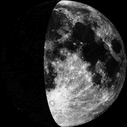
Moon Phase for June 5th at Midnight
3.3 Days Before Full "Strawberry" Moon
3.3 Days Before Full "Strawberry" Moon
"June 9, 9:10 a.m. EDT – Full Strawberry Moon. Strawberry picking season peaks during this month. Europeans called this the Rose Moon. Since the moon arrives at apogee about 15 hours earlier, this will also be the smallest full moon of 2017. In terms of apparent size, it will appear 12.2 percent smaller than the full moon of Dec. 3."
_____________________________________________________________
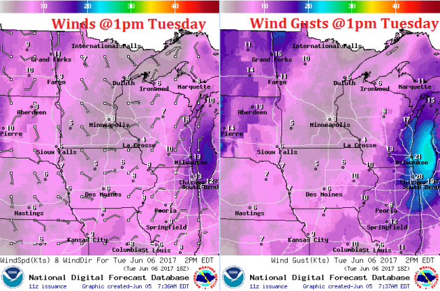
Weather Outlook for Tuesday
Winds will be lighter on Tuesday as an area of high pressure settles into the region. This will also help to keep skies mostly clear once again. Enjoy!
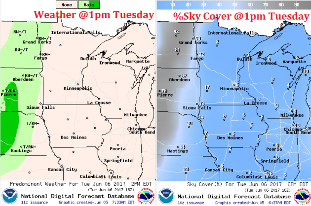
Weather Outlook for Tuesday
As an area of high pressure settles into the region on Tuesday, mostly clear skies will prevail. Note the area of rain/thunder sitting across the Eastern Dakotas, this is the weather that could move in later Wednesday into Thursday. While it doesn't appear to bring much in the way of heavy rainfall, it will make for a little more unsettled weather.
Warm Sunny Thursday, Then Warm & Muggy With Storms
Here's the weather outlook from Tuesday to PM Thursday, which shows relatively quiet weather continuing Tuesday and the early part of Wednesday before spotty showers and storms begin popping across the region. The storms won't be very widely scattered, but a few could produce locally heavy rainfall.
.gif)
Extended Rainfall Forecast
Here's the extended rainfall forecast through Friday morning. Scattered showers and storms will produce heavier rainfall across the Eastern Dakotas and across Northwestern Minnesota, but much of Central MN, including the Twin Cities could be left high and dry as the front sneaks through.
_________________________________________________________________
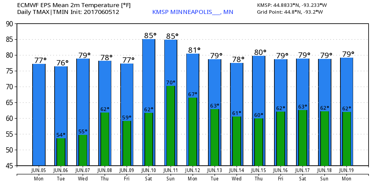
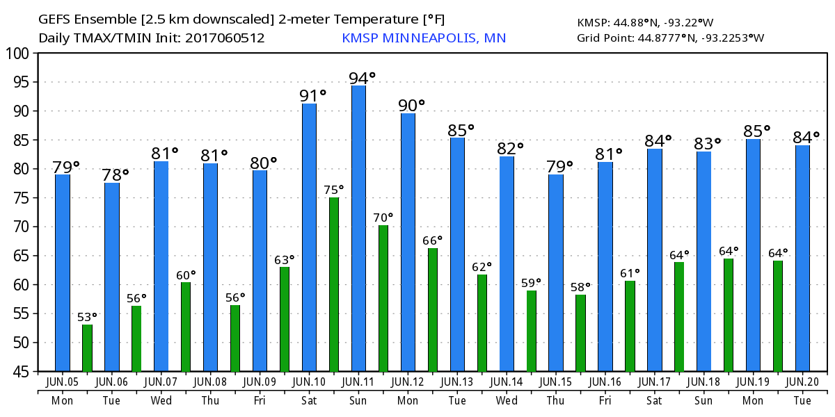
Temperature Outlook
Here's the temperature outlook from 2 different models through the the 3rd weekend of June. Note that the ECMWF keeps highs in the mid 80s this weekend, while GEFS brings highs in the low to mid 90s through Monday. Stay tuned for more!
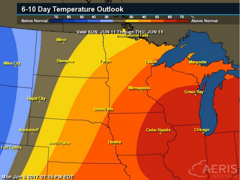
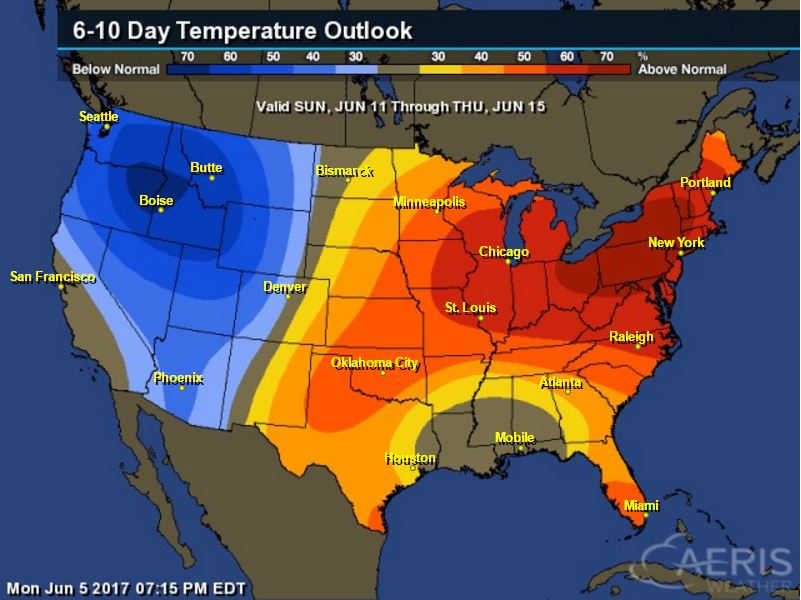
8 to 14 Day Temperature Outlook
According to NOAA's CPC, the extended temperature outlook through June 15th suggests warmer than average temperatures moving in across the Upper Midwest and Great Lakes Region.
___________________________________________________________
Extended Temperature Outlook
According to NOAA's CPC, the extended temperature outlook through June 15th shows warmer than average temperatures settling in across the Eastern two-thirds of the nation, while the Western third of the nation will be cooler.
 ____________________________________________________________
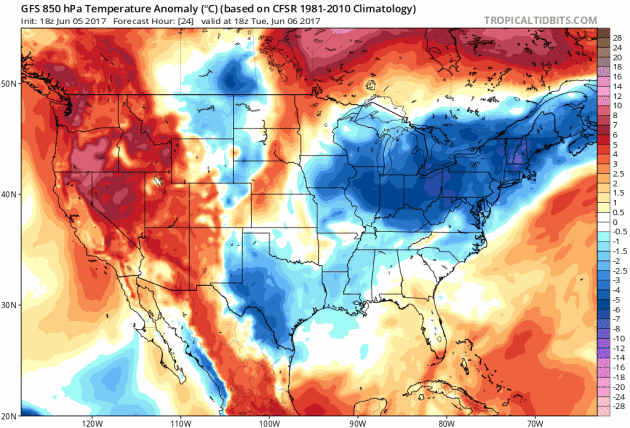
Temperature Trend
Here's the temperature trend through the middle part of next week. Cooler air looks to continue in the Eastern US through the weekend. Meanwhile, a big blob of warmer than average weather develops in the Western US and pushes into the Central and Eastern US by the weekend and next week.
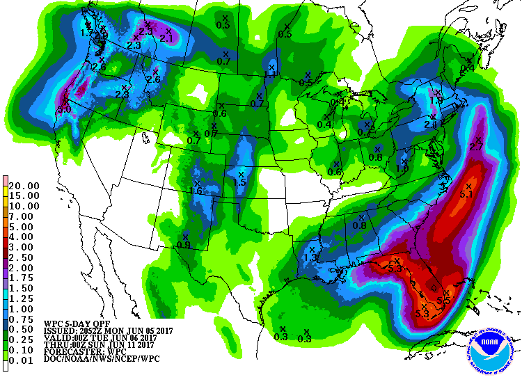
Heavy rain will continue across the Southeastern US with spotty severe weather concerns through midweek. There will also be spotty thunderstorms and could be strong to severe along the Front Range of the Rockies.
5 Day Precipitation Outlook
According to NOAA's WPC, the next several days could produce areas of locally heavy rainfall in the Eastern half of the country and especially across the Southeastern US where some 3" to 5" maybe possible. Another area of heavy rainfall could be found across the Pacific Northwest, while the Desert Southwest looks to remain very dry.
 ____________________________________________________________________
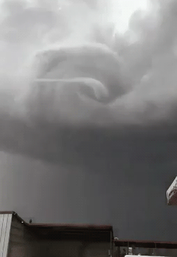
"This storm in Mexico is probably what the end of the world would look like"
"If I’m imagining an end-of-the-world montage, a la the “Day After Tomorrow,” this storm would definitely make the cut. I had to watch the video three times before I was convinced it wasn’t faked or altered because it’s Just. So. Perfect. (People can do crazy things with editing software these days and I refuse to be labeled gullible.) It’s a supercell thunderstorm, which means it has a rotating updraft. It’s impossible to tell whether this is the end stage of a previously larger tornado or if this was the storm’s main show. This storm could have had a big tornado on the ground for a while and this is just the “rope” stage as the twister dissipates."
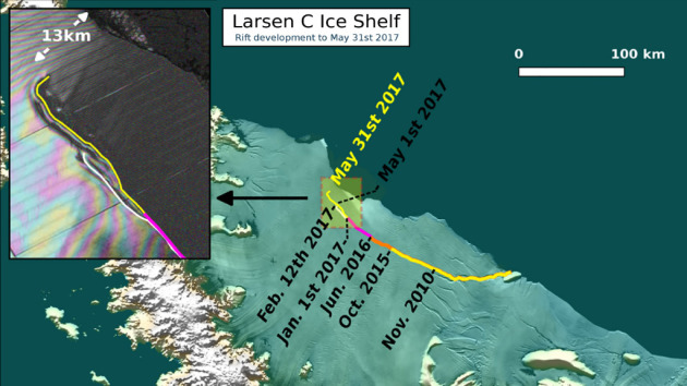
"Fractured Antarctic ice sheet will create the largest iceberg ever recorded"
Due to global warming and rising temperatures, glaciers are slowly melting – and, in some cases, breaking apart. A massive 8-mile crack is steadily growing along Antarctica’s Larsen C Ice Shelf – and when it splits, the resulting iceberg will be around 1,930 square miles (5,000 square kilometers) in size. That’s as big as Delaware – making it quite possibly the largest iceberg ever recorded.
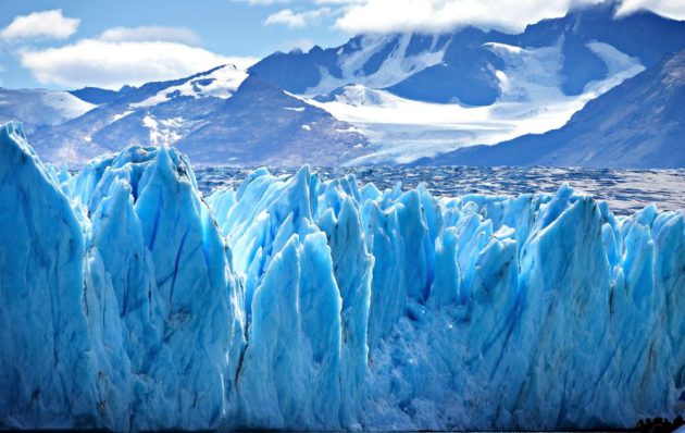
"The widening rift in the Larsen C ice shelf in West Antarctica has reached a (relative, for ice) fever pitch in the past few months, stretching for more than 110 miles and gaping more than 1,000 feet across. In just the last couple of days, the crack grew another 11 miles and took a sharp right turn toward the sea. It now ends a mere eight miles from totally breaking through, according to observations from ice-monitoring mission Project Midas. The iceberg that forms will be bigger than Long Island. Or as big as Delaware. Or roughly the size of Prince Edward Island, if you’re Canadian."
See more from Grist.org HERE:
____________________________________________________________________________"6 Dangerous Objects Lurking Near Earth"
Space is a dangerous place for humans. There’s no air, it’s ridiculously cold and things are really far apart, meaning help would be hard to come by in an emergency. But space is also dangerous for things that are much larger, like planets. As Earth innocently swings along its orbit, there are objects lurking out there that could kill our dear blue marble — and all of us on it.
See more from IBTimes.com HERE:
(This artist’s rendering shows a supermassive black hole devouring a star, which leaves behind a stream of light as it descends into its own destruction. Photo: NASA/JPL)

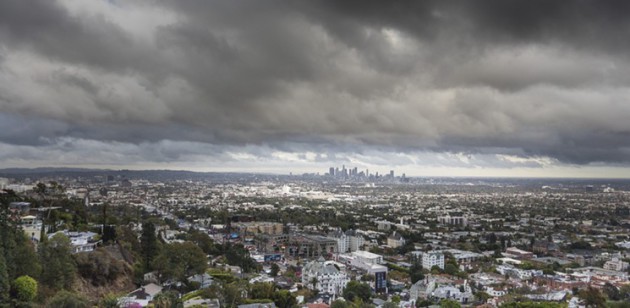
_______________________________________________________________________"In Praise of June Gloom, L.A.'s Most Underappreciated Weather Event"
"People may praise L.A.'s copious supply of sunshine or wax poetic about the Santa Ana Winds, but if there's one weather event in Southern California that is woefully underappreciated, it's June Gloom. It's the calm before the summer swelter, the two or three months of moody and mild weather that precede the scalding months of July, August and September. The May Gray/June Gloom phenomena are seen all over the Pacific Coast, though they're especially pronounced in Southern California (since a foggy day isn't exactly noteworthy in Seattle or San Francisco). Essentially, what happens is that the air starts to warm up in May, but the waters of the Pacific Ocean are still relatively cold. That causes condensation, which creates a marine layer — a thin layer of low-lying clouds over the ocean, which forms overnight and then creeps over the land during the morning. There are a few other factors involved, including something called the Catalina Eddy, where the island redirects upper-level northwesterly air flow onto the Southland."
See more from LAWeekly.com HERE:
(Jacob Avanzato / Flickr via LAWeekly.com)
_________________________________________________________________"Scientists study atmospheric waves radiating out of hurricanes"
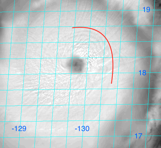
"Researchers believe they have found a new way to monitor the intensity and location of hurricanes from hundreds of miles away by detecting atmospheric waves radiating from the centers of these powerful storms. In a new study, scientists from the University of Miami (UM) Rosenstiel School of Marine and Atmospheric Science and the Hurricane Research Division of the National Oceanic and Atmospheric Administration (NOAA) presented direct observations of the waves, obtained by NOAA aircraft flying in hurricanes and by a research buoy located in the Pacific Ocean. The waves, known as atmospheric gravity waves, are produced by strong thunderstorms near the eye and radiate outward in expanding spirals. "These very subtle waves can sometimes be seen in satellite images," said David Nolan, professor in the Department of Atmospheric Sciences, and lead author of the study. "We were able to measure them in aircraft data and surface instruments." In addition, says Nolan, computer simulations performed at the UM Center for Computational Science can reproduce the waves, showing that the wave strengths can be related to the maximum wind speed in the core of the storm. These findings suggest that hurricanes and typhoons could be monitored from hundreds of miles away with relatively inexpensive instruments, such as barometers and anemometers, much like earthquakes from around the world are monitored by seismometers."
See more from Phys.org HERE:
___________________________________________________________"NASA's IceBridge Mission Ends Its 'Best Year Ever'"
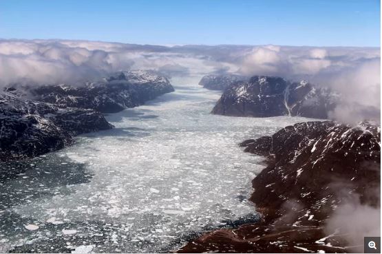
"An airplane, a satellite and volumes of data — these are at the core of NASA's 2017 airborne survey of Arctic ice cover, which recently ended. On May 12, the agency's Operation IceBridge conducted its final full science flight over central southern Greenland to track the future orbit of NASA's Ice, Cloud and land Elevation Satellite-2 (ICESat-2), which is scheduled to launch in 2018. One of Operation IceBridge's main goals is to support ICESat-2 and help fill gaps in data collection. However, the airborne missions alone have advanced scientific understanding of Arctic sea and land ice since the program launched nine years ago. [In Images: Greenland's Gorgeous Glaciers] Operation IceBridge has provided valuable data on how climate change is affecting polar ice, according to NASA. Among other things, the flights helped scientists compile the first map to show thawing on the bottom of the massive Greenland Ice Sheet and improved snowfall accumulation models for Greenland, agency officials said in a statement."
See more from Space.com HERE:
(The last Operation IceBridge flight of the 2017 Arctic campaign passed over a fjord in southern Greenland, on May 12, 2017. Credit: John Sonntag/NASA)
__________________________________________________________________________
Thanks for checking in and don't forget to follow me on Twitter @TNelsonWX

No comments:
Post a Comment