73 F. high temperature yesterday in the Twin Cities.
80 F. average high on June 18.
89 F. high on June 18, 2016.
June 19, 2014:
Heavy rain leads to widespread flooding in the Twin Cities metro area.
Minnehaha Creek has its record crest of 17.64 feet on this date. Eden
Prairie records 5.47 inches of rain, while MSP airport receives 4.13
inches, the highest daily total in 5 years.
June 19, 1955: Hailstones the size of hen's eggs fall in Roseau County.
June 19, 1955: Hailstones the size of hen's eggs fall in Roseau County.
 Complaint About Our Weather? Stand In Line
"You can please some of the people some of the time, all of the people some of the time, some of the people all of the time, but you can never please all of the people all of the time," complained Abraham Lincoln. To which I say, amen.
These days we can't seem to agree on much of anything, including the weather. "Paul, I love the cooling breeze, but it's too chilly for the lake!" Or "Paul, I appreciated the 30 minute shower for my garden, but it totally messed up a graduation party!" My advice: write your Congressman. I'm just a bewildered spectator.
That's the thing about fickle summer convection. One town can be getting clobbered with hail and high water. Five miles up the road the sun is out and locals are wondering what all the fuss is about.
Expect a touch of September today with low humidity; a clipper whips up a shower tonight with more widespread showers Wednesday as warmer air approaches. Expect a cool bias until late next week, when hot, steamy air returns. 80s and heavy T-storms for the 4th? Yep.
And Tropical Storm Bret may form in the Gulf of Mexico this week.
Spaghetti Plot. Here are the model tracks for Invest 93, an 80% chance of strengthening into a tropical storm (Bret) within 48 hours, according to NOAA's National Hurricane Center. Residents living along or near the Gulf Coast from Pensacola to Houston should pay attention. Source: Tropicaltidbits.com.
3 KM NAM Solution. The 00z run shows a fairly strong hurricane in the western Gulf of Mexico by Wednesday morning. So far the European model runs are not nearly this aggressive in strengthening the system. Water temperatures are warmer than average, but significant wind shear may shred the storm before it has much of a chance to intensify. Map: WeatherBell.

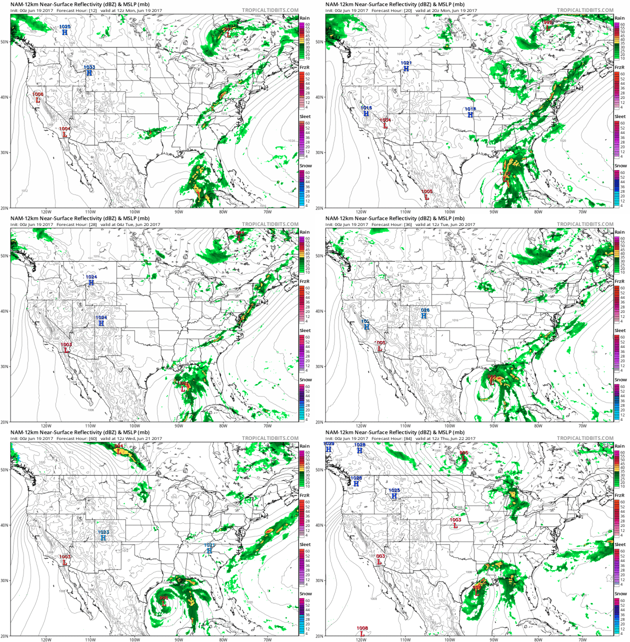
Watch for Westward Wobble. Confidence levels are still low, but there's little doubt the storm in the Gulf will be a flood-maker, regardless of whether it becomes a tropical storm or hurricane. Right now it appears Louisiana may see the most rain from a 3-4 day event, possibly some 10-15" amounts. NOAA's 12 KM NAM (above) pushes the center of the storm close to the Louisiana coastline before a westward wobble and possible landfall over Texas. It's still too early to feel confident about track or intensity.
Early Hurricane Season May Be Brewing Something in the Gulf of Mexico. 4 Things to Know. Meteorologist Marshall Shepherd helps us keep some sense of perspective at Forbes: "It is that time of year. It is hurricane season, and nature seems to know that as well. As a meteorology professor and scientist, I have been watching weather models over the past several days, and some have hinted, as far back as last week, at the possibility of "something developing" in the Gulf of Mexico. I tend to err on the side of caution with long-range solutions and let the information evolve. Too often, models spin up "fantasy" storms at long range so it is important to be cautious in what is shared. This current threat is now within a time window that warrants a little more attention. Here are 4 things that you need to know right now..."
File image of Hurricane Dennis: NASA.
Enhanced Severe Risk. Dangerous storms may impact a high-population zone later today from Albany and New York City to Philadelphia and Washington D.C. Large hail and straight-line wind damage is the primary risk, but keep in mind that a few supercell T-storms may spin up brief tornadoes.
It's June. California Is Still Covered in Snow. Climate Central reports: "The summer solstice is just around the corner, but someone forgot to tell California’s snowpack.
After years of wallowing in drought, this winter walloped California’s
Sierra Nevada mountains in a major, record-setting way. And while the
calendar says summer, winter still has its grips on the granite spine of
the Sierras. NASA Earth Observatory
released satellite imagery on Thursday that shows what a difference a
year makes. Snowpack is at 170 percent of normal when averaged across
the state and some areas are reporting way higher totals than that,
according to the California Department of Water Resources. Alpine
Meadows, located just west of Lake Tahoe, reported 288 inches of snow on
the ground (no, that’s not a typo) as of early June. Deep green hues of
healthy vegetation also extend down the Sierra Nevada western slope,
another benefit of all that precipitation..."
Map credit: "Snowpack around the Hetch Hetchy Reservoir in California in June 2016 vs. June 2017." Left: June 7, 2017. Right: June 20, 2016. Credit: NASA Earth Observatory
Lightning Myths and Facts. NOAA has a page with some very good reminders:
Myth: If you're caught outside during a thunderstorm, you should crouch down to reduce your risk of being struck.
Fact: Crouching doesn't make you any safer outdoors. Run to a substantial building or hard topped vehicle. If you are too far to run to one of these options, you have no good alternative. You are NOT safe anywhere outdoors. See our safety page for tips that may slightly reduce your risk.
Fact: Crouching doesn't make you any safer outdoors. Run to a substantial building or hard topped vehicle. If you are too far to run to one of these options, you have no good alternative. You are NOT safe anywhere outdoors. See our safety page for tips that may slightly reduce your risk.
Myth: Lightning never strikes the same place twice.
Fact: Lightning often strikes the same place repeatedly, especially if it's a tall, pointy, isolated object. The Empire State Building is hit an average of 23 times a year
Fact: Lightning often strikes the same place repeatedly, especially if it's a tall, pointy, isolated object. The Empire State Building is hit an average of 23 times a year
Myth: If it’s not raining or there aren’t clouds overhead, you’re safe from lightning.
Fact: Lightning often strikes more than three miles from the center of the thunderstorm, far outside the rain or thunderstorm cloud. “Bolts from the blue” can strike 10-15 miles from the thunderstorm.
Fact: Lightning often strikes more than three miles from the center of the thunderstorm, far outside the rain or thunderstorm cloud. “Bolts from the blue” can strike 10-15 miles from the thunderstorm.
Myth: Rubber tires on a car protect you from lightning by insulating you from the ground.
Fact: Most cars are safe from lightning, but it is the metal roof and metal sides that protect you, NOT the rubber tires. Remember, convertibles, motorcycles, bicycles, open-shelled outdoor recreational vehicles and cars with fiberglass shells offer no protection from lightning. When lightning strikes a vehicle, it goes through the metal frame into the ground. Don't lean on doors during a thunderstorm...
Fact: Most cars are safe from lightning, but it is the metal roof and metal sides that protect you, NOT the rubber tires. Remember, convertibles, motorcycles, bicycles, open-shelled outdoor recreational vehicles and cars with fiberglass shells offer no protection from lightning. When lightning strikes a vehicle, it goes through the metal frame into the ground. Don't lean on doors during a thunderstorm...
File image: Jorge Silva, Reuters.
Sharp Uptick in Wildfires Strains Great Plains Agencies. A story at Climate Central caught my eye: "...The spreading rash of fires across the flat and grassy states west of the Mississippi River has jolted a region unaccustomed them, even as it has been overshadowed in the news and dwarfed in firefighting budgets by bigger wildfires tearing up the West Coast. “The low frequency tends to lull all of us into a sense of complacency,” said Michele Steinberg, manager of wildland fire operations at the nonprofit National Fire Protection Association. “We have a long way to go with education, particularly for folks where they have not seen a lot of fire.” Because wildfires have been relatively rare in the Great Plains until recently, many states and counties have come to depend heavily on each other for assistance when they strike. “They rely on their neighbors,” Steinberg said. But the shared firefighting resources are becoming strained as more fires need to be fought. “You’re seeing conditions that are just right for not only ignition of fire, but also fire spread,” Steinberg said..."
Photo credit: "The Mule Ridge Wildfire in Arizona last year." Credit: U.S. Forest Service/Flickr.
How Logos Became the Most Important Quarter-Inch in Business. Fortune.com explains: "...For starters, a logo isn’t just a name or an icon or other visual signature on company letterhead or a billboard or other promotional venue anymore. Take that device out of your pocket or bag and swipe through the screens, as you probably do many times a day anyway. You now carry dozens of brand icons wherever you go. “People are literally, physically interacting with those symbols in a way that they never did,” says Michael Bierut, partner in the prominent design firm Pentagram. For the Facebooks and Airbnbs and Snapchats and Ubers of the world in particular, he continues, that means “their customers are having a really, really intimate sort of relationship not just with those brands, but with the symbols that represent the brands...”
Illustration credit: 123 Klan for Fortune.
Image credit: "Experiments with the Micius satellite could propel China to the forefront of hack-proof communications. Professor Hoi Fung Chau of Hong Kong University explains how quantum physics can be used to frustrate hackers." Photo: CCTV

Amazon's Move Signals End of Line For Many Cashiers. Following up on the implications of Amazon swallong the world; here's a clip from The New York Times: "Imagine this scene from the future: you walk into a store and are greeted by name, by a computer with facial recognition that directs you to the items you need. You peruse a small area - no chance of getting lost or wasting time searching for things - because the store stocks only sample items. You wave your phone in front of anything you want to buy, then walk out. In the back, robots retrieve your items from a warehouse and deliver them to your home via driverless car or drone. Amazon's $13.4 billion purchase of Whole Foods, announced Friday, could speed that vision along..."

The 21 Unwritten Rules of Flying You're Probably Breaking. Thrillest has a good start: "...The
secret to sloshing a billion people through terminals, security lines,
and airplanes without utter chaos breaking out? A complex, unspoken
social code nearly everyone observes. Most people simply get it. Then,
there are the nail-clipping, baby-cussing, pajama-wearing, 9/11-joke
making, full-bottle-of-water-in-the-TSA-line-carrying dumbasses. Look
around on your next flight and you’re sure to spot one, blithely
clobbering people with his backpack, unwrapping a hot fish sandwich, and
cranking his seat back to full recline the second you hit 10,000 feet.
Some transgressions are obvious. Others, ambiguous moral gray zones you
yourself have struggled with. Here, we wrote ‘em down. Now you know what
all those glares have been trying to tell you..."
Illustration credit: Daniel Fishel/Thrillist.
50 States of Glorious Hiking Destinations. Popsugar.com breaks out some of the best hikes in all 50 states, with a non-obvious option for Minnesota: "...From forests and grasslands to marshes and wetlands, in the Lebanon Hills Regional Park, you'll find it all. Hiking in this 1,869-acre park is a great way to escape the city and fully immerse yourself in the natural world. And with 14 miles of heavily wooded trails right at your fingertips, chances are you'll need to visit this park more than once to experience all the serenity the Lebanon Hills have to offer..."
Image Source: Flickr user Jeremy Noble

TODAY: Cool sun, late shower or T-shower. Winds: NW 8-13. High: 71
MONDAY NIGHT: Clearing and cool. Low: 57
TUESDAY: Damp start, then sunny and pleasant. Winds: NW 8-13. High: 75
WEDNESDAY: Humid, showers likely. Winds: SE 10-15. Wake-up: 59. High: 77
THURSDAY: Unsettled, more T-storms late? Winds: NW 5-10. Wake-up: 62. High: 80
FRIDAY: Partly sunny, could be a good one. Winds: NW 8-13. Wake-up: 58. High: 79
SATURDAY: Potential for more showers, T-storms. Winds: N 5-10. Wake-up: 59. High: 72
SUNDAY: Cool for June, more showers pop up. Winds: NW 10-15. Wake-up: 56. High: 68
Climate Stories...
If Trump Won't Fight Climate Change, We Must - For the Troops' Sake. Here's an excerpt from Defense One: "...Choosing not to take action against climate change will put our troops in harm’s way more often in the not-so-distant future. Here’s why: The Pentagon has long acknowledged climate change as a “threat multiplier” because its effects make the work of our men and women in uniform around the world even more difficult than it already is. More frequent and severe storms and droughts—and their consequences, including resource shortages and mass migration—mean the U.S. military will be asked take on more humanitarian relief missions, there will be stronger extremist groups on the battlefield, and possibly worse. These aren’t fringe views. Defense Secretary Jim Mattis made the argument himself in his confirmation hearing testimony..."
Photo credit: Marko Drobnjakovic "U.S. Army soldiers move through Qayara West Coalition base in Qayara, some 50 kilometers south of Mosul, Iraq."

Antarctica is Melting, and Giant Ice Cracks Are Just The Start. What can possibly go wrong. Here's an excerpt from National Geographic: "Seen from above, the Pine Island Ice Shelf is a slow-motion train wreck. Its buckled surface is scarred by thousands of large crevasses. Its edges are shredded by rifts a quarter mile across. In 2015 and 2016 a 225-square-mile chunk of it broke off the end and drifted away on the Amundsen Sea. The water there has warmed by more than a degree Fahrenheit over the past few decades, and the rate at which ice is melting and calving has quadrupled. On the Antarctic Peninsula, the warming has been far greater—nearly five degrees on average. That’s why a Delaware-size iceberg is poised to break off the Larsen C Ice Shelf and why smaller ice shelves on the peninsula have long since disintegrated entirely into the waters of the Weddell Sea. But around the Amundsen Sea, a thousand miles to the southwest on the Pacific coast of Antarctica, the glaciers are far larger and the stakes far higher. They affect the entire planet..."
Photo credit: "A startling sunset reddens the Lemaire Channel, off the west coast of the Antarctic Peninsula. The continent’s coastal ice is crumbling as the sea and air around it warm." Camille Seaman.

Not Your Mother's Jersey Shore. It seems Superstorm Sandy has brought about new, higher-risk real estate opportunities along the New Jersey coastline. Here's an excerpt from The New York Times: "...In response to Hurricane Sandy, New Jersey has instituted new construction regulations that follow federal standards and then some. Those people building new homes or rebuilding damaged homes in designated flood zones are required to raise their houses to the base flood elevation levels determined for each community by the Federal Emergency Management Agency, plus one extra foot, as set by the New Jersey Department of Environmental Protection..."
Photo credit: "Bill and Michele Garofalo and their children, Amanda and Billy, on their top deck in Ortley Beach." Tony Cenicola - The New York Times.
Photo credit: "TORONTO - JULY 5" via Shutterstock

No comments:
Post a Comment