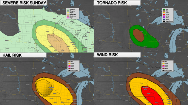
As we head through the rest of Sunday evening and into the overnight hours, there is an Enhanced Risk of severe weather from the Twin Cities to the southeast, indicating a higher chance of seeing severe weather. The main threat across this Enhanced Risk area is damaging winds, but storms will start off to the north and west during the early evening. Those storms will be capable of very large hail and a tornado or two.
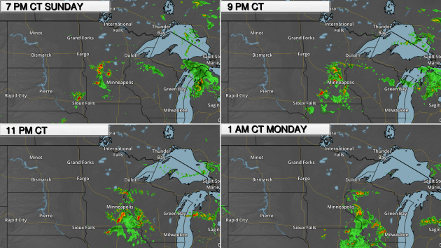
Here's a look at the potential timing for storms this (Sunday) evening in to the overnight hours:
_______________________________________________
Warm, Dry Weather Expected To Continue
Some of you might be thinking what you should do about watering the next few weeks with dry weather in the outlook. Here's some tips from University of Minnesota Extension climatologist and meteorologist Mark Seeley from his latest WeatherTalk column:
"-water plants and gardens at night or very early in the morning to minimize evaporation losses.
-use a light coating of mulch around some plants to minimize water loss from the soil, and to suppress weed competition.
-adjust your lawn mower to a higher setting as the longer grass keeps root systems shaded. During a warm July, lawns will need 1-2 inches of water per week.
-direct downspouts and other runoff towards shrubs, hedges and trees that can utilize the water.
-try to water at a rate that matches the infiltration rate of your soil....perhaps with a soaker hose.
-for newly planted trees and shrubs (planted this spring or summer) water thoroughly at least once per week all summer."
_______________________________________________
A Few Warm Blasts - Strong Storm Potential Tuesday
By DJ Kayser, filling in for Paul Douglas
Each person has their own ideal weather. For example, I'm not one that exactly enjoys the heat and humidity of summer. I much prefer the spring and fall - a cool, crisp morning with highs topping off in the 60s to 70s.
I’m not sure many people would have enjoyed some of the weather during the Dust Bowl era. This week marks the warmest week ever recorded in Twin Cities history back in 1936, when each day between the 10th and 14th saw a high of at least 105. This Friday will mark the anniversary of the warmest high ever recorded in the Twin Cities - a blistering 108.
Temperatures won't be close to that this week across southern Minnesota, though the thermometer could approach 90 a few times in the next seven days. The first attempt will be on Wednesday, when dew points will also approach 70 across southern Minnesota. Before that, though, some strong thunderstorms will be possible Tuesday into Tuesday Night, with the potential of damaging winds. Another quick blast of heat will be possible heading into next weekend.
_______________________________________________
Extended Twin Cities Forecast
MONDAY: Lingering morning storms. High 85. Low 68. Chance of precipitation 30%. Wind NE 3-5 mph.
TUESDAY: Afternoon strong thunderstorms. High 87. Low 73. Chance of precipitation 50%. Wind SE 5-10 mph.
WEDNESDAY: A few storms. Dew points near 70. High 88. Low 63. Chance of precipitation 50%. Wind S 5-10 mph.
THURSDAY: Less muggy and a touch cooler. High 83. Low 65. Chance of precipitation 0%. Wind NE 5-10 mph.
FRIDAY: Sunny skies. Warming trend begins. High 85. Low 68. Chance of precipitation 0%. Wind SE 5-10 mph.
SATURDAY: Potential of a few storms. Muggy. High 90. Low 65. Chance of precipitation 20%. Wind SW 5-10 mph.
SUNDAY: A few afternoon clouds. High 86. Low 64. Chance of precipitation 10%. Wind N 3-5 mph.
_______________________________________________
This Day in Weather History
July 10th
2002: Intense rainfall causes extensive street flooding in St. Cloud. 2.70 inches of rain falls in 1 hour and 45 minutes at St. Cloud State University. People were stranded in their cars and had to be rescued by the fire department.
_______________________________________________
Average Temperatures & Precipitation for Minneapolis
July 10th
Average High: 84F (Record: 106F set in 1936)
Average Low: 64F (Record: 49F set in 1996)
Average Precipitation: 0.13" (Record: 1.93" set in 2002)
________________________________________________
Sunrise/Sunset Times for Minneapolis
July 10th
Sunrise: 5:36 AM
Sunset: 8:59 PM
*Length Of Day: 15 hours, 23 minutes and 1 second
*Daylight Lost Since Yesterday: ~1 minute and 20 seconds
*Next Sunrise At/After 6 PM: August 2nd (6:00 AM)
*Next Sunset At/Before 8:30 PM: August 8th (8:29 PM)
________________________________________________
Minnesota Weather Outlook
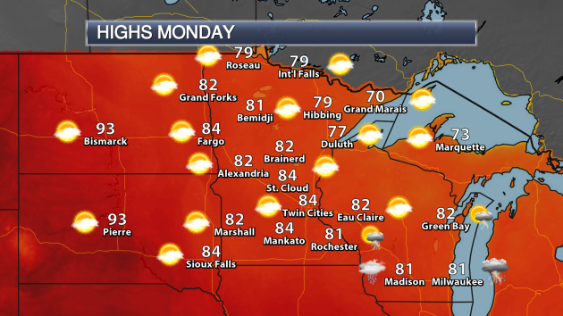
Monday
is expected to be a mainly sunny day across the state, with just a few
morning storms lingering across southern Minnesota. Highs will top off
in the 80s across central and southern Minnesota, with 70s across the
north.
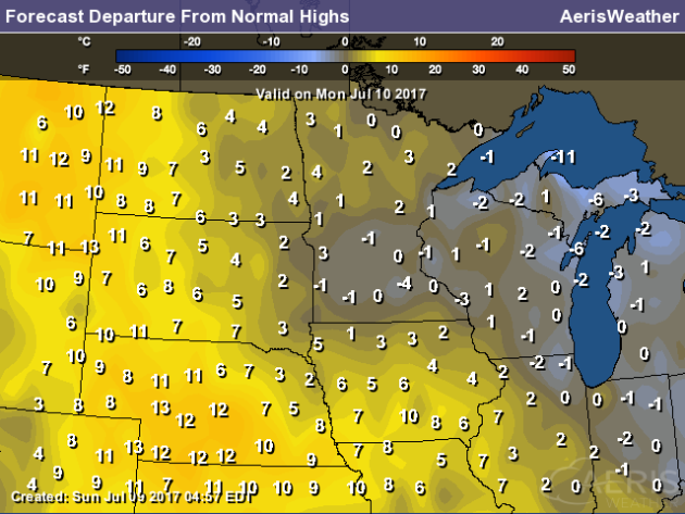
Temperatures
on Monday will be within a few degrees of average across the state,
with the real warm weather for this time of year far to our south and
west.
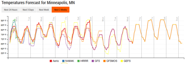
Temperatures
will approach 90 twice this week here in the Twin Cities - toward the
middle of the week and into next weekend. Models continue to try and
hint at a warm up in the extended forecast (next week), however this has
been the pattern past day seven for a while now, so only time will tell
what will happen.
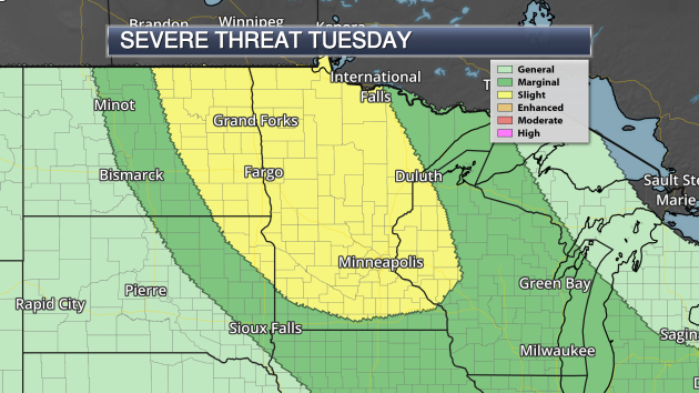
Looking
ahead, a Slight Risk of severe weather is already in place across a
good portion of Minnesota Tuesday and Tuesday Night. The current set up
shows storms forming during the afternoon hours across western
Minnesota, capable of large hail, damaging winds and a few tornadoes.
Storms will eventually merge into a line as they head east and
southeast, posing more of a damaging wind threat into the evening and
overnight hours.
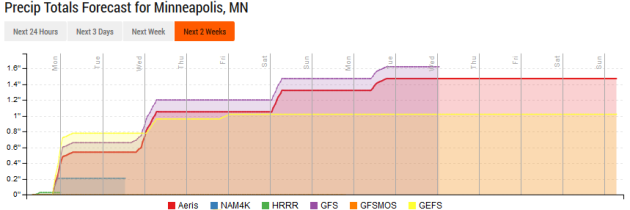
Models
have come into some sort of alignment for rain chances over the next
several days. The next chance of accumulating rain comes with the severe
risk Tuesday into Wednesday, with about a half an inch of rain
possible. The next chance comes in Friday Night/Saturday, with maybe a
quarter inch. Another chance is there as we head toward the beginning of
next week.
_______________________________________________National Weather Outlook
Monday Forecast
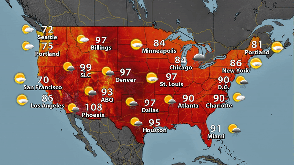
The
heat is (still) on across the central and southwest United States on
Monday, with highs in the 90s or higher in spots. We'll be tracking
numerous showers and storms across the country during the day.
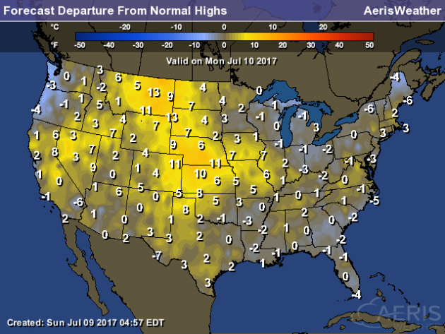
Areas
from the Northern High Plains to the Central Plains will see highs that
are 5-15 degrees above average on Monday. The most concentrated areas
of cooler than average weather will be observed in the Pacific Northwest
and into parts of Maine.
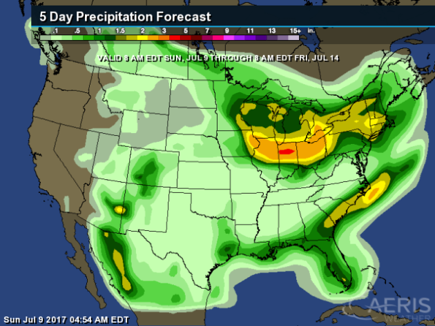
The
lower Great Lakes could see 2-4" of rain through the end of the week as
we watch a few batches of storms move through the region. Up to 2" of
rain will be possible across parts of eastern Georgia northward into
eastern North Carolina. Meanwhile, monsoonal storms in the desert
southwest could bring pockets of heavy rain across the region.
_______________________________________________
90 Degree Days So Far Nationwide
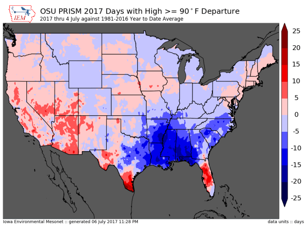
This map, courtesy of IEM
and OSU PRISM, shows the number of 90 degree days vs. average through
July 4th across the country. A good portion of the Southeast and lower
Mississippi Valley has seen lots of rain so far this summer, helping to
bring them fewer 90 degree days than normal so far. Areas that have seen
more 90 degree days than average include parts of the Southwest,
southern Texas and the peninsula of Florida.
Extreme Drought In The Dakotas, Montana
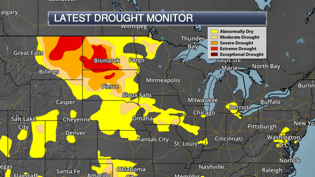
Drought
has quickly been spreading across parts of the northern Plains over the
past month or so. As of the latest Drought Monitor, released last
Thursday, 29.3% of North Dakota was under Extreme Drought along with
12.9% of Montana.
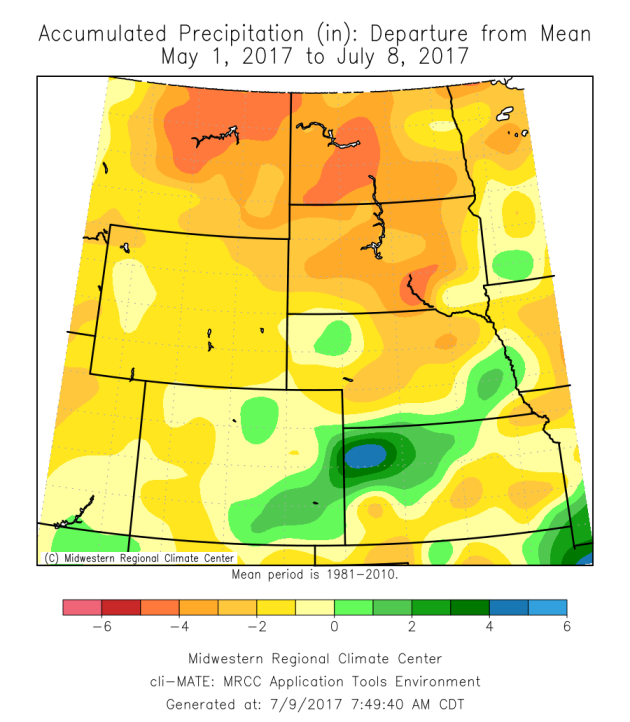
Many
areas are running a good 4-6"+ behind on rainfall since May, with some
areas seeing some of their driest months in recent history. I found this
information interesting from the latest Drought Monitor: "On July
1st, the National Weather Service Office in Glasgow, Montana reported
several dry precipitation records were broken for Glasgow including: the
driest May and June (0.72 inches) since 1918; the driest April, May,
and June (1.24 inches) since 1918; and the driest January through June
(2.75 inches) since 1983."
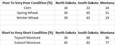
This
drought is having a huge effect on crops and soil conditions across the
region, with deteriorating pasture and crop conditions. Above is a
table compiled from the latest USDA Crop Progress report,
issued on the 5th, showing that a majority of the corn and wheat crops
are in poor to very poor condition and moisture in the soil is short.
Another update will be issued on Monday.
Long Flash Of Lightning In Minnesota
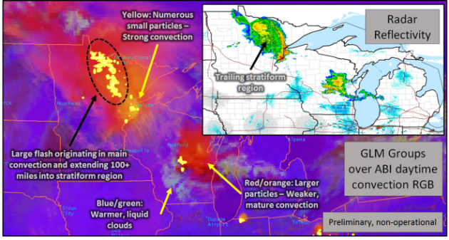
The
Geostationary Lightning Mapper - a new lightning detector on the
GOES-16 satellite - captured a long flash of lightning last month in
Minnesota. More from NASA SPORT: "The
GLM observes a flash that extends well behind the main convection
(observed by the radar mosaic) and spans over 100 miles. The extent is
roughly between Duluth, Minnesota and International Falls, Minnesota.
This example shows the importance that the spatial extent of GLM
observations can play in lightning safety as the threat of lightning is
non-zero, even after the main convective line has passed."
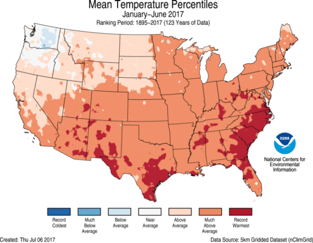
NOAA
released numbers for the first half of the year Friday (along with June
climate numbers), and the first half of the year ended up being the
second warmest on record for the lower 48. According to the news release: "The
year-to-date (YTD, January through June 2017) average temperature was
50.9 degrees F, 3.4 degrees above the 20th-century average. This was the
second warmest first-half of the year in the record, 1.2 degrees cooler
than 2012. The YTD precipitation total for the Lower 48 states was
17.86 inches, 2.55 inches above average. This ranked as the sixth
wettest YTD on record."
Big Stories In June: Southwest Heat and Southeast Rain
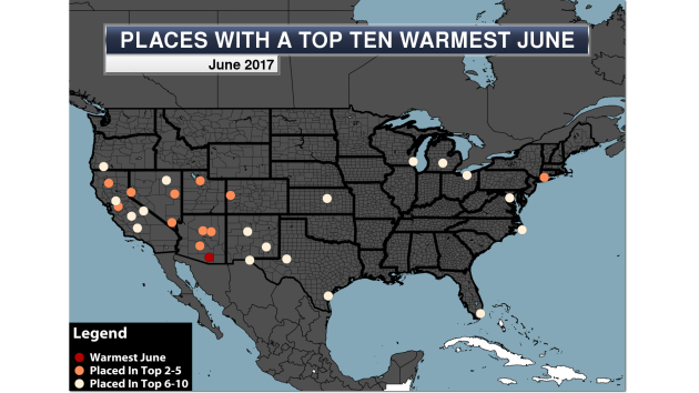
Tucson,
AZ saw their warmest June on record as the Southwest scorched,
meanwhile Tropical Storm Cindy contributed to the wettest June on record
in Gainesville, FL. More from Praedictix: "The
heat dominated parts of the middle and end of June 2017 in the
Southwest, with numerous locations setting daily records... with some
seeing consecutive days in a row with record temperatures! The peak of
the heat appeared to occur around June 20th, when Phoenix saw a record
high of 119 (tying for their 4th warmest high ever on record) and Las
Vegas hit 117 (tying for the warmest temperature ever recorded in Las
Vegas history). This heat only allowed one location, however, to see
their warmest June on record - that was in Tuscon, AZ, which saw four
record highs during the month and shattered numerous all-time
consecutive day streak records."
Nine U.S. Billion Dollar Disasters In First Half Of 2017
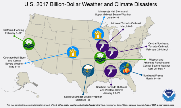
According
to NOAA, there were nine extreme weather events during the first half
of 2017 that each added up to at least a billion dollars in damage.
There were 57 deaths in these nine events which included two floods and a
freeze. It wasn't the most on record for the first half of the year,
however - that record is 10, set in both 2011 and 2016. There was a
grand total of 15 billion dollar events last year.
100 Billion "Failed Stars"

Image: NASA / JPL-Caltech
Ready To Be Godzilla?

You
might have the opportunity to virtually fly through cities in iOS 11
according to a new feature discovered in the beta builds. More from Gizmodo: "With
the introduction of iOS 11 and a development tool called ARKit, Apple
is betting that augmented reality could be the next revolutionary
feature for smartphones. At the very least, it’s facilitated a secret
feature that lets iPhone users pretend they’re giant monsters stomping
through a tiny city."
Want Some Vinegar With Your Wheat?
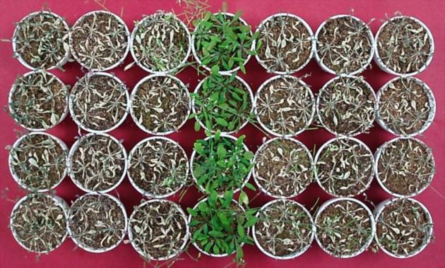
A
new study has found that crops like rice and wheat can continue to
prosper in drought conditions - if they are grown in acetate, which is
found in vinegar. More from Popular Science: "With
the threat of climate change looming, farmers and scientists alike are
realizing that crops have become more resistant to events like droughts
if we want to maintain a reliable food source. It sounds—and sort of
looks—like something out of a middle school science experiment, but
according to a study done at RIKEN Center for Sustainable Resource
Science in Japan, a new and simple way to increase a plant's drought
tolerance is to grow it in vinegar."
Image: "After 14 days in drought conditions, only the plants treated with acetic acid (in the middle column) survived. (RIKEN)"
Volvo To Go All Hybrid Or Electric By 2019

One
bold step for an auto maker? Volvo announced earlier this week that
every new model they release, starting in 2019, will be either partially
or fully electric. WIRED, however, doesn't think it is all that bold: "But
take a close look and it will become evident that going electric isn't
that risky at all. The international winds of regulation blow toward gas
and diesel alternatives. The industry's Next Big Thing—autonomous
vehicles—will be battery-powered. Even consumers, especially those at
the top of the market—the place where Volvo’s customers like to
hang—look to be interested in EVs. So, in reality, Volvo and its
competitors are being pushed into electric propulsion. The Swedes are
just rolling with it—and boasting that they're driving the change."
Image: Volvo Car Corporation
______________________________
Thanks for checking in and have a great Monday! Don't forget to follow me on Twitter (@dkayserwx) and like me on Facebook (Meteorologist D.J. Kayser)!
- D.J. Kayser

No comments:
Post a Comment