_______________________________________________
Sunday Afternoon Storms - Highs Right Around Average
By DJ Kayser, filling in for Douglas
Where does the time go?
It feels like summer just started yesterday, but here we are - quickly approaching the middle of July. As we do so, we are also entering what is, on average, the warmest part of the year. Our average high tops off at 84 each day between July 6th and the 21st, and then it’s all downhill from there (at least until the middle of winter).
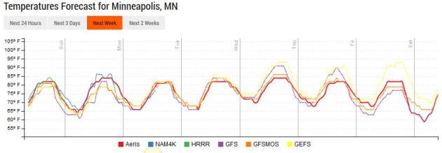
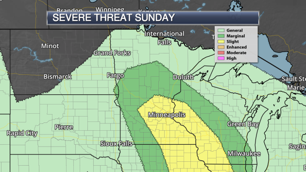
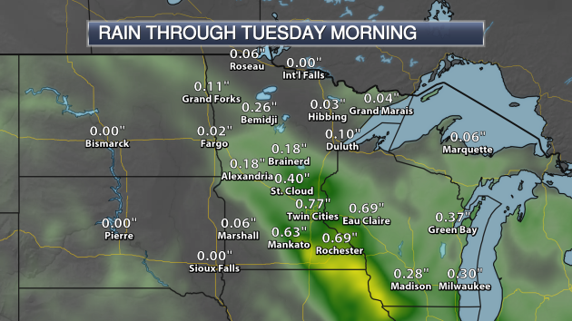
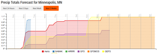
Luckily, temperatures will hang within a few degrees of average over the next week. Storms – some of which could be on the strong side – will be possible later today, bringing the potential of over a half an inch of rain. More downpours will be possible toward the middle of the week as another system moves through the region. That will bring the return of very muggy conditions as well as dew points will be hovering around 70 once again by Wednesday. After that, we look to end the week on a nice note, with sunnier skies.
Make sure to make time to get out and enjoy the nice, summer weather while you can. Fall will probably creep up on you faster than you think!
_______________________________________________
Extended Twin Cities Forecast
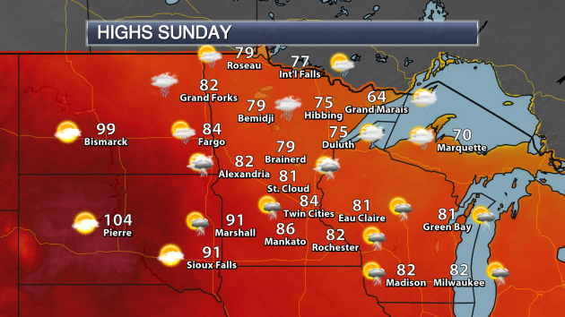
SUNDAY: Afternoon storm potential. High 86. Low 66. Chance of precipitation 40%. Wind SW 5-10 mph.
MONDAY: Lingering morning storms across southern Minnesota. High 84. Low 66. Chance of precipitation 20%. Wind NE 3-5 mph.
TUESDAY: Muggy conditions. Storms possible late. High 87. Low 69. Chance of precipitation 20%. Wind SE 5-10 mph.
WEDNESDAY: Dewpoints near 70. Scattered afternoon storms. High 88. Low 68. Chance of precipitation 20%. Wind W 5-10 mph.
THURSDAY: Decreasing clouds. Not as muggy. High 84. Low 67. Chance of precipitation 10%. Wind N 5-10 mph.
FRIDAY: Highs around average. Mainly sunny. High 84. Low 65. Chance of precipitation 10%. Wind SW 5-15 mph.
SATURDAY: A nice, sunny summer day expected. High 86. Low 67. Chance of precipitation 10%. Wind S 5-10 mph.
_______________________________________________
This Day in Weather History
July 9th
1932: A tornado touches down near Springfield and moves into St. James, causing 500 thousand dollars in damage.
_______________________________________________
Average Temperatures & Precipitation for Minneapolis
July 9th
Average High: 84F (Record: 99F set in 1976)
Average Low: 64F (Record: 48F set in 1895)
Average Precipitation: 0.14" (Record: 2.55" set in 2000)
________________________________________________
Sunrise/Sunset Times for Minneapolis
July 9th
Sunrise: 5:35 AM
Sunset: 9:00 PM
*Length Of Day: 15 hours, 24 minutes and 21 seconds
*Daylight Lost Since Yesterday: ~1 minute and 16 seconds
*Next Sunrise At/After 6 PM: August 2nd (6:00 AM)
*Next Sunset Before 9 PM: July 10th (8:59 PM)
________________________________________________
Minnesota Weather Outlook
_______________________________________________
National Weather Outlook
Sunday Forecast
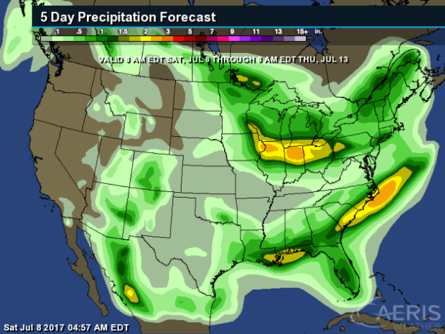
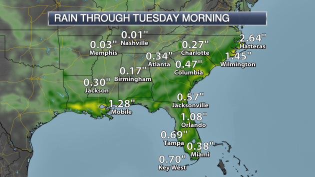
Taking
a closer look at Southeast, places like Mobile, Orlando and Cape
Hatteras could end up with over an inch of rain through the end of the
weekend and into early next week.
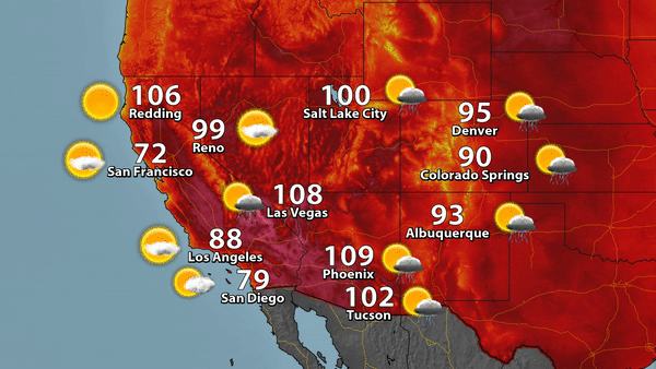
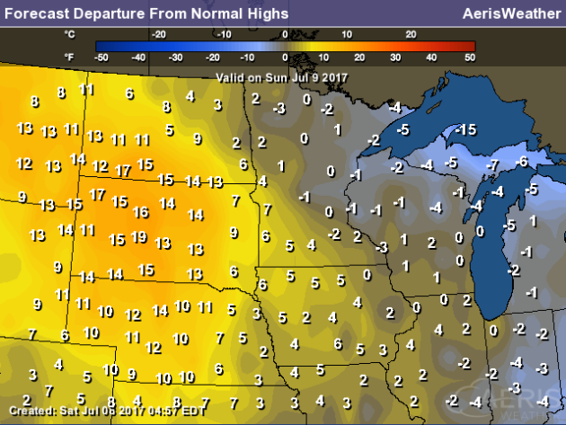
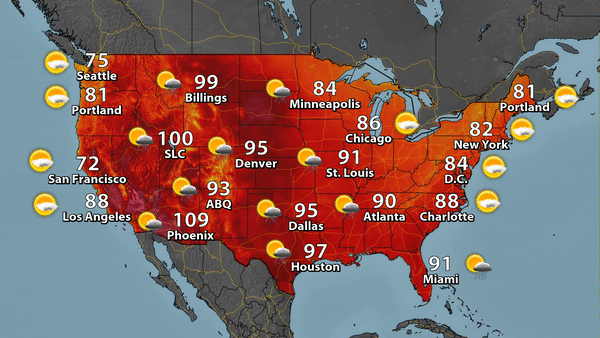
Meanwhile,
across the Southwest the heat won't be as extreme as it has been the
past few days on Sunday, with temperatures backing off a few degrees in
areas like Phoenix and Las Vegas. We won't see nearly as many record
highs, either.
_______________________________________________
Record Setting Tornadoes In Maine

Last
Saturday (July 1st) was a record breaking day in Maine, as five
tornadoes touched down on a single day. That beats the previous record
of four, set in July of 2010. More from the Portland Press Herald: "The
weather service confirmed Wednesday that an EF-0 tornado, the weakest
category, touched down near Otisfield around 6:35 p.m. Saturday, packing
maximum wind speeds of 75 mph. It cut a 75-yard wide path for 2.5 miles
from Bolsters Mill Road, where it pushed tree branches onto power
lines, to Bell Hill Road, where a large pine tree fell on a house. The
tornado also blew down trees on Peaco Hill Road and Rayville Road in
Otisfield."
Lower 48 Saw Second Warmest Start To Year On Record
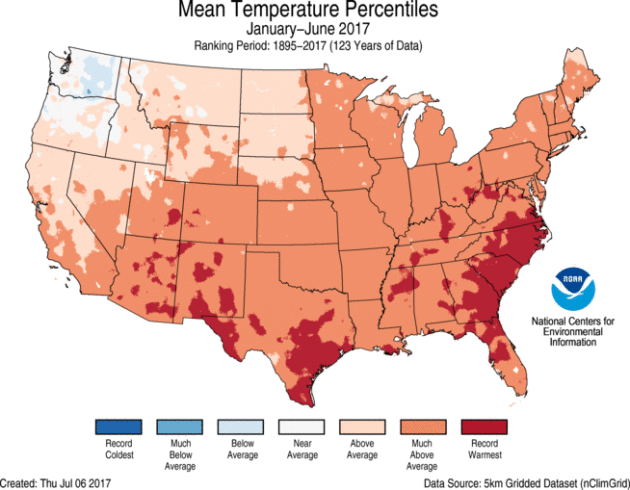
NOAA
released numbers for the first half of the year Friday (along with June
climate numbers), and the first half of the year ended up being the
second warmest on record for the lower 48. According to the news release: "The
year-to-date (YTD, January through June 2017) average temperature was
50.9 degrees F, 3.4 degrees above the 20th-century average. This was the
second warmest first-half of the year in the record, 1.2 degrees cooler
than 2012. The YTD precipitation total for the Lower 48 states was
17.86 inches, 2.55 inches above average. This ranked as the sixth
wettest YTD on record."
Big Stories In June: Southwest Heat and Southeast Rain
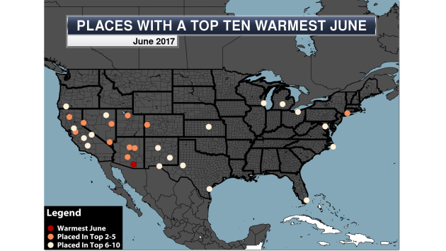
Tucson,
AZ saw their warmest June on record as the Southwest scorched,
meanwhile Tropical Storm Cindy contributed to the wettest June on record
in Gainesville, FL. More from Praedictix: "The
heat dominated parts of the middle and end of June 2017 in the
Southwest, with numerous locations setting daily records... with some
seeing consecutive days in a row with record temperatures! The peak of
the heat appeared to occur around June 20th, when Phoenix saw a record
high of 119 (tying for their 4th warmest high ever on record) and Las
Vegas hit 117 (tying for the warmest temperature ever recorded in Las
Vegas history). This heat only allowed one location, however, to see
their warmest June on record - that was in Tuscon, AZ, which saw four
record highs during the month and shattered numerous all-time
consecutive day streak records."
Nine U.S. Billion Dollar Disasters In First Half Of 2017
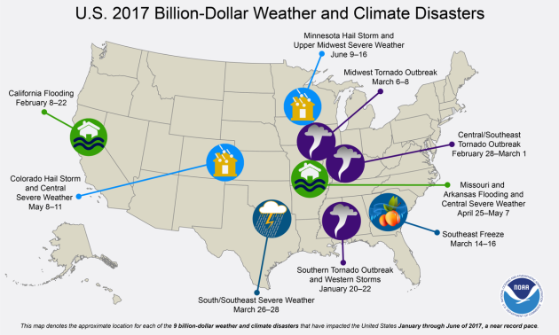
According
to NOAA, there were nine extreme weather events during the first half
of 2017 that each added up to at least a billion dollars in damage.
There were 57 deaths in these nine events which included two floods and a
freeze. It wasn't the most on record for the first half of the year,
however - that record is 10, set in both 2011 and 2016. There was a
grand total of 15 billion dollar events last year.
Rain Delay... But With No Rain?
That's
exactly what occurred Thursday Night at the Nationals vs. Braves game
in Washington D.C. So why did this happen? It's unclear - but the Capital Weather Gang tried to figure it out: "We’re
going to remember Thursday night’s Nationals vs. Braves game — not for
shutout pitching or a game-winning RBI by Anthony Rendon, but for a
three-hour rain delay that included everything but rain. Fans at the
park were annoyed, right up to the moment they left without seeing any
baseball. Managers were blaming the meteorologists. Park officials were
mopping up the damage on social media. Even the players were doling out
the snark."
100 Billion "Failed Stars"

Image: NASA / JPL-Caltech
Ready To Be Godzilla?

You
might have the opportunity to virtually fly through cities in iOS 11
according to a new feature discovered in the beta builds. More from Gizmodo: "With
the introduction of iOS 11 and a development tool called ARKit, Apple
is betting that augmented reality could be the next revolutionary
feature for smartphones. At the very least, it’s facilitated a secret
feature that lets iPhone users pretend they’re giant monsters stomping
through a tiny city."
Want Some Vinegar With Your Wheat?

A
new study has found that crops like rice and wheat can continue to
prosper in drought conditions - if they are grown in acetate, which is
found in vinegar. More from Popular Science: "With
the threat of climate change looming, farmers and scientists alike are
realizing that crops have become more resistant to events like droughts
if we want to maintain a reliable food source. It sounds—and sort of
looks—like something out of a middle school science experiment, but
according to a study done at RIKEN Center for Sustainable Resource
Science in Japan, a new and simple way to increase a plant's drought
tolerance is to grow it in vinegar."
Image: "After 14 days in drought conditions, only the plants treated with acetic acid (in the middle column) survived. (RIKEN)"
Volvo To Go All Hybrid Or Electric By 2019

One
bold step for an auto maker? Volvo announced earlier this week that
every new model they release, starting in 2019, will be either partially
or fully electric. WIRED, however, doesn't think it is all that bold: "But
take a close look and it will become evident that going electric isn't
that risky at all. The international winds of regulation blow toward gas
and diesel alternatives. The industry's Next Big Thing—autonomous
vehicles—will be battery-powered. Even consumers, especially those at
the top of the market—the place where Volvo’s customers like to
hang—look to be interested in EVs. So, in reality, Volvo and its
competitors are being pushed into electric propulsion. The Swedes are
just rolling with it—and boasting that they're driving the change."
Image: Volvo Car Corporation
______________________________
Thanks for checking in and have a great Sunday! Don't forget to follow me on Twitter (@dkayserwx) and like me on Facebook (Meteorologist D.J. Kayser)!
- D.J. Kayser

No comments:
Post a Comment