Stormy Tuesday Night/Early AM Wednesday
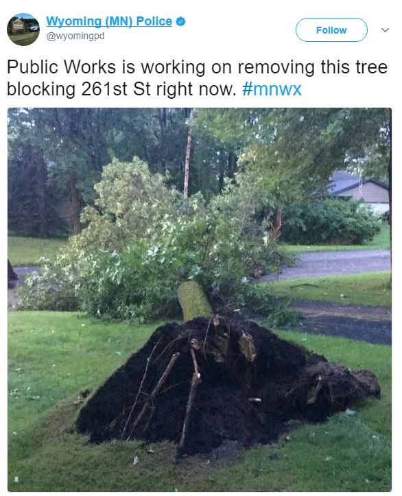
Thanks to the Wyoming Police Department for the image below where severe thunderstorms blasted through early Wednesday morning and created a lot of wind damage. The police department there tweeted quite a few photos of downed trees and even power lines.
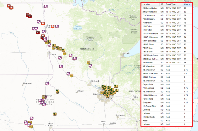
The storm report map from PM Tuesday to AM Wednesday shows quite a bit of wind damage reports on the north and eastern side of the Twin Cities Metro, while a number of large hail, damaging wind and even tornado reports across the eastern Dakotas and western Minnesota.
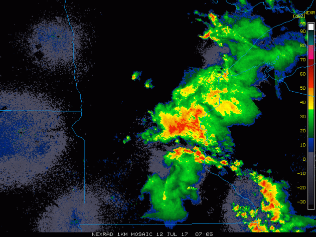
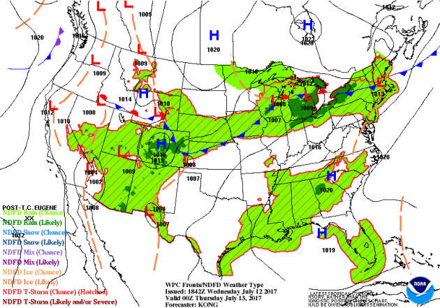
Tuesday Night/AM Wednesday Radar
The radar loop from overnight Tuesday into early Wednesday morning showed a very large cluster of storms pushing through the region. Some of these storms were severe with damaging winds and locally heavy rainfall.
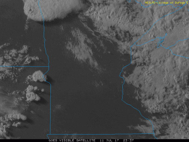
Visible Satellite From PM Tuesday
The visible satellite image from PM Tuesday/AM Wednesday shows explosive thunderstorms developing along the Dakota/Minnesota border late in the day. These thunderstorms developed very quickly in what was a very unstable atmosphere on Tuesday, which went on to produce large hail, damaging winds and even tornadoes!
The good news is that our severe weather threat will be very low over the next could of days. In fact, chances of any type of thunder remain very low across the state on Thursday and Friday.
.png)
.png)
Simulated Radar
The simulated radar from midday Thursday to midday Saturday shows mostly quiet conditions across the region. A bubble of high pressure will slowly drift through the Midwest, which will allow mostly dry weather to stick around through the end of the week, but there could be a few isolated rumbles late Saturday as this feature drops into the Middle Mississippi Valley.
.gif)
The extended forecast is calling for mostly dry conditions across parts of the region over the next several days. The only spot that may get into a little moisture could be across the far northern part of the state, where up to a few tenths of an inch maybe possible. With mostly dry weather ahead and with as much heat and humidity that is in the forecast through next week, things could get quite dry quite fast. Generous watering of lawns and gardens maybe in the works.
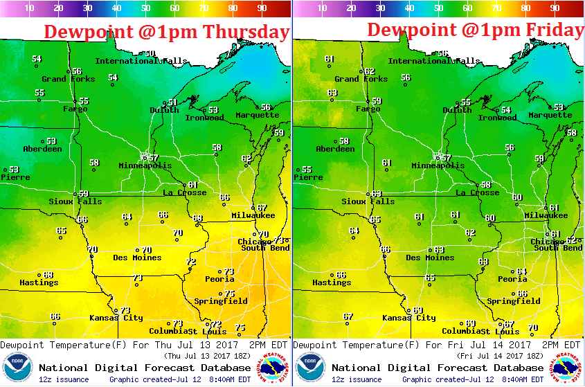
A Brief Break in the Humidity Thursday & Friday
Ahh... this looks better. Dewpoints are expected to fall into the 50s cross much of the state on Thursday and Friday. This will certainly be much nicer than what we had earlier this week and what is expected to bubble up again by the weekend. With that said, enjoy the brief break in humidity now because it'll feel downright thick and soupy next week!
___________________________________________________________________________
Eastern Pacific Outlook: Post-Tropical Cyclone EUGENE
EUGENE officially faded on Wednesday and became a post-tropical cyclone. At one point earlier this week, EUGENE was a category 2 hurricane with sustained winds up to 100mph!
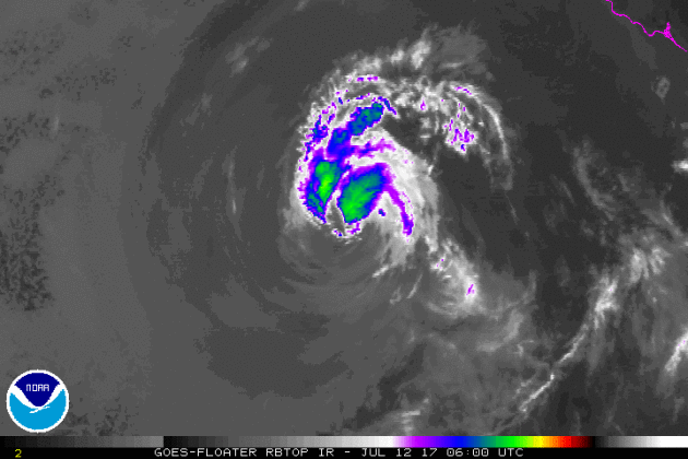
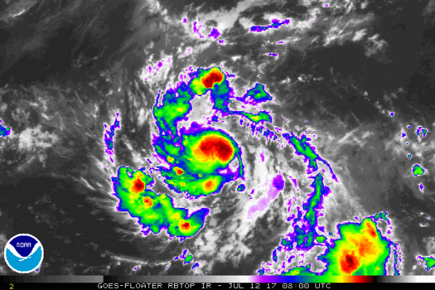
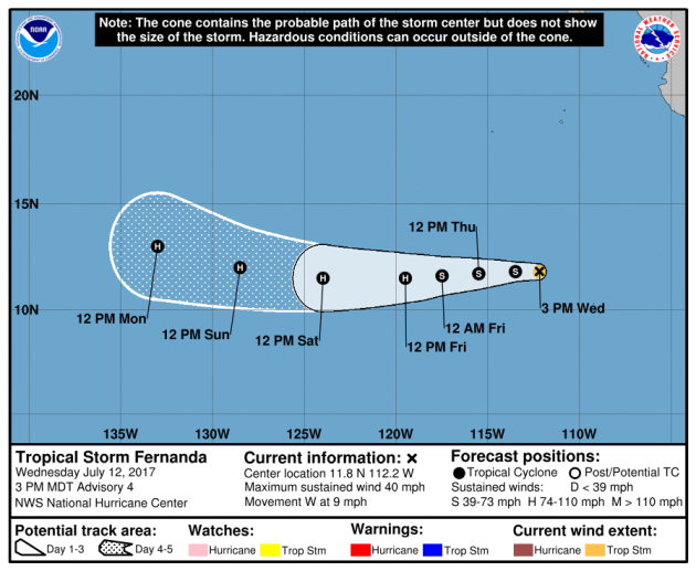
Tropical Storm FERNANDA
The National Hurricane Center is tracking another storm in the Eastern Pacific, which as of early Wednesday became our sixth named storm (FERNANDA) of the 2017 Eastern Pacific Hurricane Season. The loop below from early Wednesday showed quick organization with this system as it went from tropical depression strength to tropical storm strength
Tracking Tropical Storm FERNANDA
Here's the official track for FERNANDA, which has it becoming a hurricane by the end of the week and if it does, it will become the 3rd hurricane of the season behind DORA and EUGENE. The good news is that the forecast track has it continuing to drift west away from any major landmass.
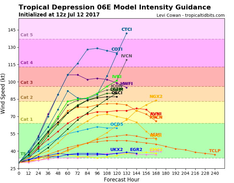
Here's an interesting image. This is the forecast from a number of different models regarding the potential strength of FERNANDA over time. Note that the models have this ranging from tropical storm strength to a potential category 5 hurricane. That is a major spread in models... Stay tuned to see what happens.
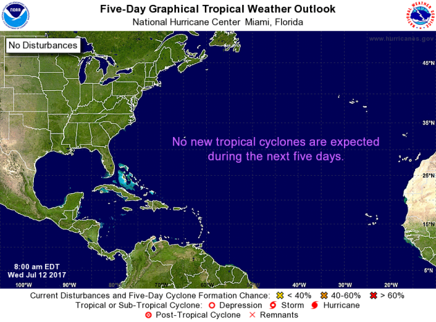
Meanwhile, the Atlantic basin looks fairly quiet with no tropical activity expected over the next 5 days. Stay tuned...
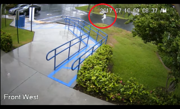
The Broward County Sheriff’s Office is reporting a swim instructor and lifeguard was jolted by a lightning strike that hit a nearby concrete pole Monday morning. According to sheriff spokesman Mike Jachles, the 27-year-old woman was about 300 feet from the pole when the lightning struck. She was taken to Florida Medical Center where she was treated and released.
See the video from PalmBeachPost.com HERE:
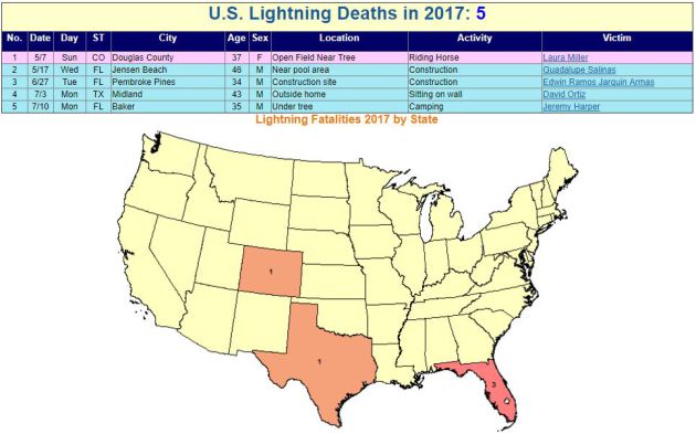
 _______________________________________________________________________2017 Lightning Fatalities
According to NOAA's NWS, there have been 5 lightning fatalities so far this year. Note that 3 of those deaths have occurred in Florida, which is considered to be the lightning capital of the United States.
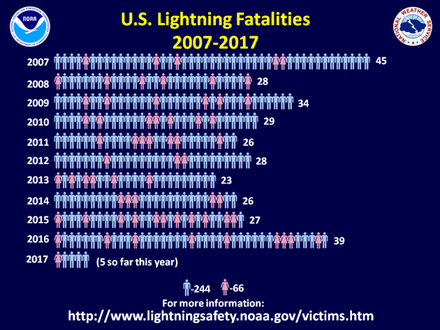
 Lightning Deaths Over the Last 10 Years
According to NOAA's NWS, lightning kills an average of 47 people each year in United States! Over the last 10 years, 310 people have died from lightning and what is interesting is that nearly 79% have been males!
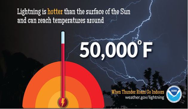
 Lightning Safety: Myths & Facts
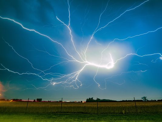
Did you know that lightning is nearly 5 times hotter than the surface of the sun? Here are a few interesting myths and facts from NOAA's NWS regarding lightning:
Myth: If you're caught outside during a thunderstorm, you should crouch down to reduce your risk of being struck.
Fact: Crouching doesn't make you any safer outdoors. Run to a substantial building or hard topped vehicle. If you are too far to run to one of these options, you have no good alternative. You are NOT safe anywhere outdoors. See our safety page for tips that may slightly reduce your risk.
Myth: Lightning never strikes the same place twice.
Fact: Lightning often strikes the same place repeatedly, especially if it's a tall, pointy, isolated object. The Empire State Building is hit an average of 23 times a year
Myth: If it’s not raining or there aren’t clouds overhead, you’re safe from lightning.
Fact: Lightning often strikes more than three miles from the center of the thunderstorm, far outside the rain or thunderstorm cloud. “Bolts from the blue” can strike 10-15 miles from the thunderstorm.
Myth: Rubber tires on a car protect you from lightning by insulating you from the ground.
Fact: Most cars are safe from lightning, but it is the metal roof and metal sides that protect you, NOT the rubber tires. Remember, convertibles, motorcycles, bicycles, open-shelled outdoor recreational vehicles and cars with fiberglass shells offer no protection from lightning. When lightning strikes a vehicle, it goes through the metal frame into the ground. Don't lean on doors during a thunderstorm.
Myth: A lightning victim is electrified. If you touch them, you’ll be electrocuted.
Fact: The human body does not store electricity. It is perfectly safe to touch a lightning victim to give them first aid. This is the most chilling of lightning Myths. Imagine if someone died because people were afraid to give CPR!
Myth: If outside in a thunderstorm, you should seek shelter under a tree to stay dry.
Fact: Being underneath a tree is the second leading cause of lightning casualties. Better to get wet than fried!
See more on lightning including safety tips HERE:
 ___________________________________________________________________________
National Weather Hazards Ahead...
See the video from PalmBeachPost.com HERE:
According to NOAA's NWS, there have been 5 lightning fatalities so far this year. Note that 3 of those deaths have occurred in Florida, which is considered to be the lightning capital of the United States.
According to NOAA's NWS, lightning kills an average of 47 people each year in United States! Over the last 10 years, 310 people have died from lightning and what is interesting is that nearly 79% have been males!
Did you know that lightning is nearly 5 times hotter than the surface of the sun? Here are a few interesting myths and facts from NOAA's NWS regarding lightning:
Myth: If you're caught outside during a thunderstorm, you should crouch down to reduce your risk of being struck.
Fact: Crouching doesn't make you any safer outdoors. Run to a substantial building or hard topped vehicle. If you are too far to run to one of these options, you have no good alternative. You are NOT safe anywhere outdoors. See our safety page for tips that may slightly reduce your risk.
Myth: Lightning never strikes the same place twice.
Fact: Lightning often strikes the same place repeatedly, especially if it's a tall, pointy, isolated object. The Empire State Building is hit an average of 23 times a year
Myth: If it’s not raining or there aren’t clouds overhead, you’re safe from lightning.
Fact: Lightning often strikes more than three miles from the center of the thunderstorm, far outside the rain or thunderstorm cloud. “Bolts from the blue” can strike 10-15 miles from the thunderstorm.
Myth: Rubber tires on a car protect you from lightning by insulating you from the ground.
Fact: Most cars are safe from lightning, but it is the metal roof and metal sides that protect you, NOT the rubber tires. Remember, convertibles, motorcycles, bicycles, open-shelled outdoor recreational vehicles and cars with fiberglass shells offer no protection from lightning. When lightning strikes a vehicle, it goes through the metal frame into the ground. Don't lean on doors during a thunderstorm.
Myth: A lightning victim is electrified. If you touch them, you’ll be electrocuted.
Fact: The human body does not store electricity. It is perfectly safe to touch a lightning victim to give them first aid. This is the most chilling of lightning Myths. Imagine if someone died because people were afraid to give CPR!
Myth: If outside in a thunderstorm, you should seek shelter under a tree to stay dry.
Fact: Being underneath a tree is the second leading cause of lightning casualties. Better to get wet than fried!
See more on lightning including safety tips HERE:
PRELIMINARY 2017 Tornado Map
It certainly has been a fairly active first half of 2017 with 1157 preliminary tornado reports through July 10th. Note that this is the most tornadoes through July 11th since 2011, when there were nearly 1,600 reports. The map below shows the distribution of the tornadoes so far this year.
.gif) PRELIMINARY 2017 Tornado Count
PRELIMINARY 2017 Tornado Count
According to NOAA's SPC, the PRELIMINARY 2017 tornado count is 1157 (through July 11). Note that is the most active year for tornadoes since 2011, when there were 1,623 tornadoes. Keep in mind there was a major tornado outbreak in the Gulf Coast region from April 25-28, 2011 that spawned nearly 500 tornadoes, some of which were deadly. That outbreak is known as the Super Outbreak of 2011 and has gone down in history as one of the biggest, costliest and one of the deadliest tornado outbreaks in history.
.png)
____________________________________________________________
According to NOAA's SPC, the PRELIMINARY 2017 tornado count is 1157 (through July 11). Note that is the most active year for tornadoes since 2011, when there were 1,623 tornadoes. Keep in mind there was a major tornado outbreak in the Gulf Coast region from April 25-28, 2011 that spawned nearly 500 tornadoes, some of which were deadly. That outbreak is known as the Super Outbreak of 2011 and has gone down in history as one of the biggest, costliest and one of the deadliest tornado outbreaks in history.
____________________________________________________________
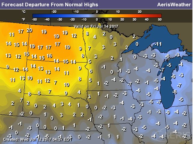
2.) Much above-normal temperatures for much of the northern Rockies and northern to central Great Plains, Sat-Tue, Jul 15-18.
3.) Excessive heat for parts of the western Corn Belt, middle Mississippi Valley, and lower Ohio Valley, Tue-Wed, Jul 18-19.
4.) Heavy rain for parts of the Southeast, Sat-Sun, Jul 15-16.
5.) Flash flooding possible for parts of the southwestern U.S., Sat-Wed, Jul 15-26.
6.) Much above normal temperatures for parts of the upper Yukon Valley, Sat, Jul 15.
7.) Excessive heat for parts of the middle Mississippi Valley and Ohio Valley, Thu, Jul 20.
8.) Slight risk of much above-normal temperatures for parts of the Pacific Northwest, northern Rockies, 9.) Great Plains, middle and lower Mississippi Valley, Southeast, and mid-Atlantic, Thu-Wed, Jul 20-26.
10.) Severe Drought across parts of the Great Plains, Arizona, California, and Hawaii.
.png)
National Weather Outlook
Here's the weather outlook through the weekend, which shows unsettled weather conditions continuing across the northern tier of the nation. Keep in mind that some of the storms could be strong to severe with locally heavy rainfall. There will also be areas of thunderstorm activity across the Intermountain West with monsoonal storms in the Desert Southwest. Also note Hurricane EUGENE fading in the Eastern Pacific as we head through the week.
.gif)
Excessive Rainfall Potential Thursday & Friday
According to NOAA's WPC, there is a risk of excessive rain on both Thursday and Friday, but Thursday looks a little more unsettled with a SLIGHT risk of excessive rainfall across parts of the Ohio Valley. There may also be isolated areas of heavy rain across parts of the Northeast and the Central Plains. By Friday the best chance of heavy rain looks to be mainly confined to parts of eastern Colorado.
.gif)
.gif)
With excessive rainfall potential in place over parts of the Ohio Valley and Northeast on Thursday, some spots could see more than 1" to 2" of rain. This heavy rain threat could lead to isolated areas of flooding!
________________________________________________________
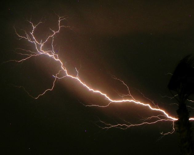
Monsoonal Storms
Thanks to my good friend Rich Koivisto from Bullhead City, AZ, who captured this impressive lightning strike during some monsoonal thunderstorms late last weekend! According to NOAA's NWS, the monsoon season was considered to have started when there were 3 three consecutive days of average dewpoint temperatures of 55 degrees or higher. That was the definition/protocol through the year 2007, but in 2008, the NWS decided to declare June 15th to September 30th the official monsoon season in Arizona. Pretty neat!
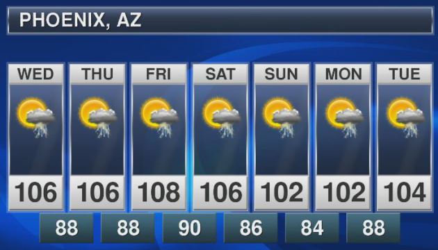
Monsoonal Storms Continue
Sure it'll be hot in Phoenix, AZ over the next few days, but hey look at the thunderstorm chances! Monsoonal storms could bubble up across the region there over the next several days! Rainfall amounts could be heavy in pockets, which could lead to areas of localized flooding across the Desert Southwest.
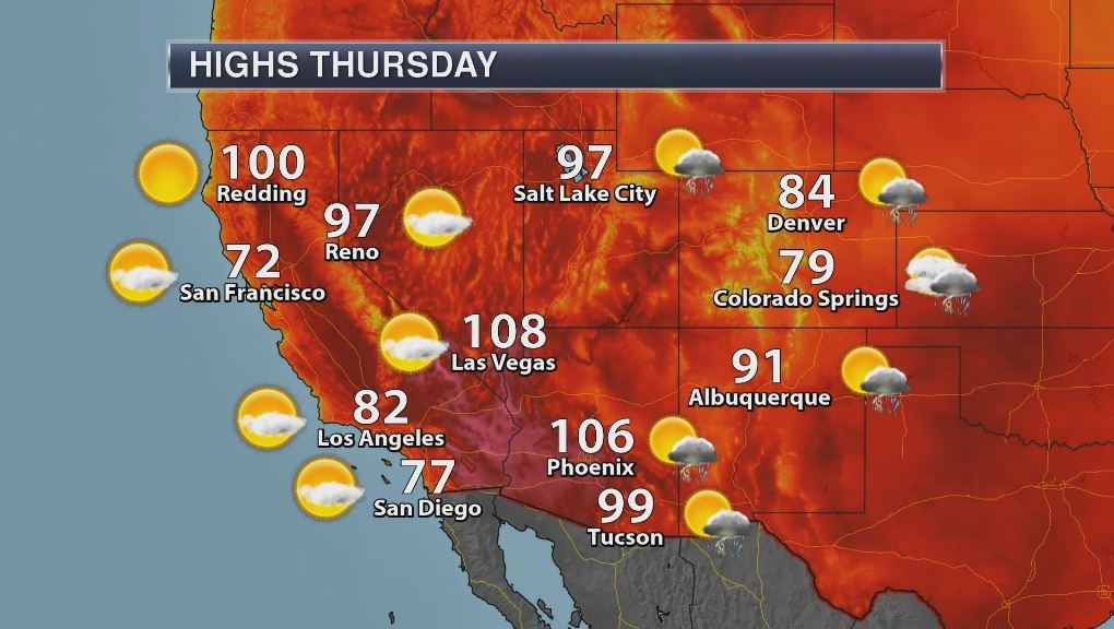
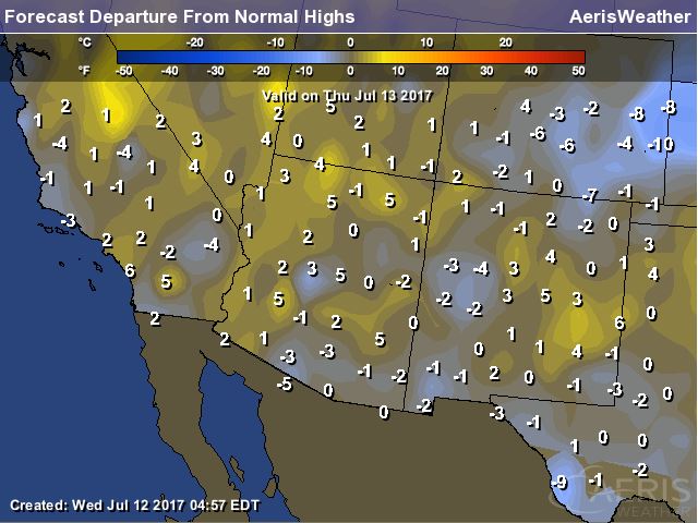
High Temps in the Southwest on Thursday
The good news is that the excessive heat has subsided in the Southwest for now. Temperatures late last week and into the weekend were at record levels in quite a few locations. Here's a look at high temperatures for Thursday, which will be pretty close to average for mid July.
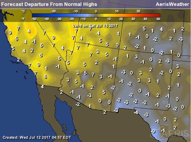
High Temperatures on Saturday
Another surge of hot air is expected to bubble up across parts of the Southwest as we head into the end of the week and weekend ahead. Some of the latest forecasts suggest that temperatures will once again be nearly 10F+ above average on Saturday!!
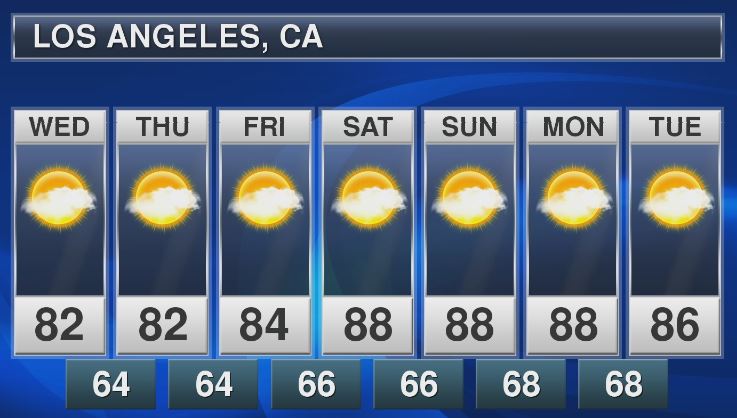
Los Angeles, CA
With temperatures on the upswing across parts of the Southwest through the end of the week and weekend ahead, places like Los Angeles, CA could once again see highs in the 90s! Here's the extended forecast through early next week, which shows near 90F highs from Saturday to Monday. WHEW!
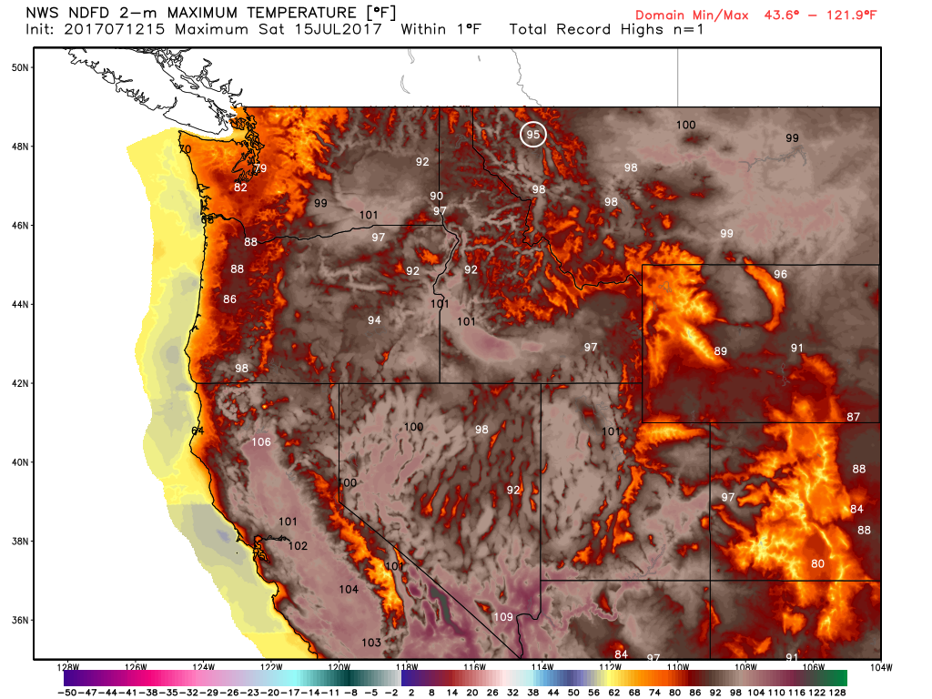
Record Heat Possible in the Northwest
The extended forecast for Saturday below suggests that record to near record heat will be building into the Northwest. Some forecasts suggest that readings could be a good 15F to 20F+ above average, especially over the weekend.
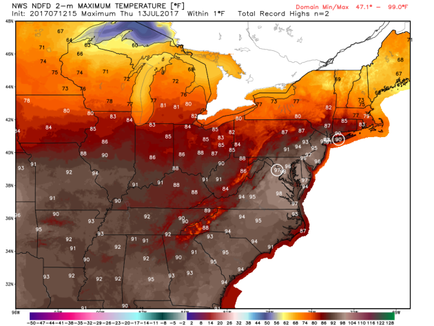
Record Heat in the Mid-Atlantic Thursday?
A surge of very warm and soupy air is expected to continue across the Mid-Atlantic region on Thursday. Some locations will be nearly 10F+ above average record highs could be possible as highs warm into the upper 90s.
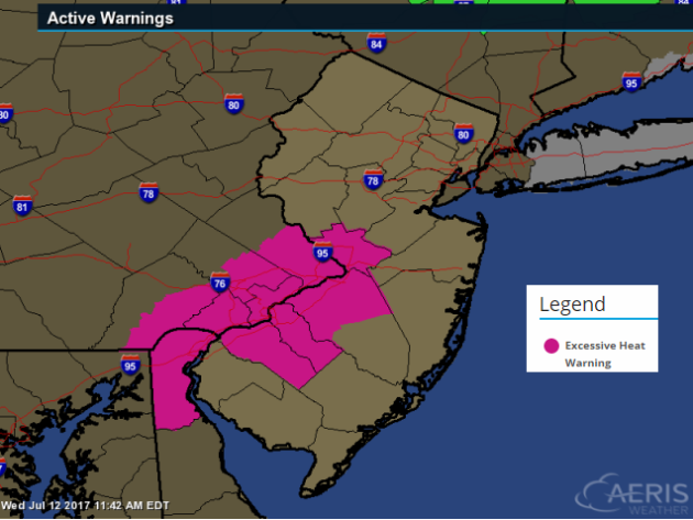
Excessive Heat Warning: Philadelphia, PA
The National Weather Service has issued an EXCESSIVE HEAT WARNING for Philadelphia, PA and surrounding areas from 11AM to 8PM Thursday for heat index values that are expected to be anywhere from 100F to 105F! Yikes... Stay cool!
________________________________________________________________________
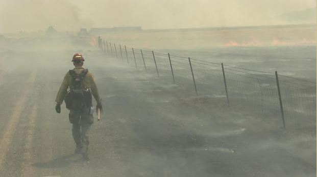
Rooster Comb Fire - Battle Mountain, Nevada
According to Inciweb, one of the largest fires currently burning in the Lower 48 is the Rooster Comb Fire located near Battle Mountain, NV. This particular fire has consumed a whopping 120,000 acres and is only 15% contained. This particular fire started on Sunday, July 9th and quickly spread as hot, dry and windy weather created extreme fire behavior. An influx of new crews and equipment have been checking in and there are currently 467 people working on the fire. The estimated containment date is projected for Monday, July 17th.
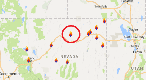
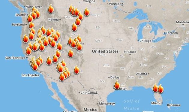
Ongoing Large Wildfires
Here's a look at the current wildfire map across the country. Recent hot and dry weather has helped to spark several wildfires across the Western US, while a few have also been popping up in the Eastern US.
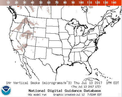
National Smoke Analysis
Here's the projected wildfire smoke concentration for midday Thursday. Note that much of the smoke from the western wildfires will be mainly confined to the Western US. If you are in these areas, air quality could be quite poor, but these areas may also be enjoying very interesting looking sunrises/sunsets, which tend to look hazy or reddish-orange.
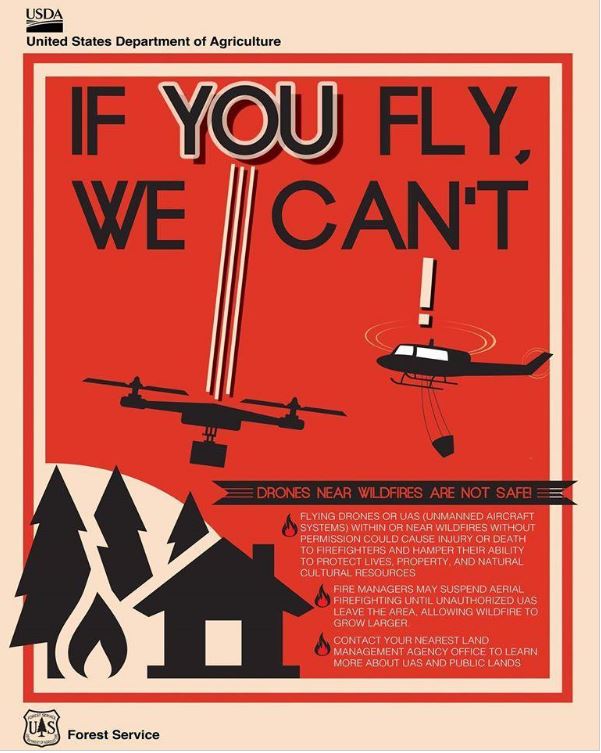
Here's an interesting story regarding drones causing air support to be grounded during wildfires! Here's the latest from Fox 31 in Denver (KDVR): "Fire departments statewide are pleading with the public to follow the rules when it comes to drones around active wildfires. Flying high above the ground, drones give a bird’s-eye view of the world. From cityscapes to places off-limits to the public, they can soar into fires like never before. “We certainly see the benefit in fact South Metro is seeing a few people to get properly trained,” South Metro Fire Rescue spokesman Eric Hurst said. However, sometimes drones can also be a hazard for fire crews. On Saturday, South Metro was one of four agencies responding to a grass fire in Sedalia. The 18-acre fire required air support but couldn’t utilize it as planned. “During [Saturday’s] incident, one of our fire crews observed a drone flying around the scene, so that triggers a lot of concerns for us,” Hurst said. A drone in the immediate area of a wildfire makes conditions too unsafe for airplanes. If the two collide, it could cause the plane to crash. “The pilots don’t want to be up in the air when they can’t communicate with another aircraft that’s flying next to them,” Hurst said. A similar situation happened at the Lightner Creek Fire in Durango last week. Planes carrying fire retardant were forced to drop their loads early and leave the area because of an unauthorized drone in the flight path. “We don’t want any kind of an accident to happen so at that point, aircraft is going to have to be grounded until we can find out who’s operating the drone and we can get them to stop,” Hurst said."
 ________________________________________________________________________
Break in humidity Thursday, but sweaty by Saturday
By Todd Nelson, filling in for Douglas
According to NOAA, lightning kills an average of 47 people in the United States each year. Over the last 10 years, there have been 310 lightning deaths across the country and remarkably, 79% of those people have been males!
If you can hear thunder, you are close enough to get struck! "When thunder roars, go indoors." Also remember the 30-30 rule. If you see lightning and can hear thunder within 30 seconds, seek shelter immediately. Then, wait 30 minutes after the last rumble to resume any outdoor activities. More info at LightningSafety.NOAA.gov
Folks are still cleaning up after severe storms downed a number of trees and power lines north of the metro on Wednesday morning. A cooler and less humid breeze will make it a quite comfortable outdoor work day Thursday. Enjoy it because things look to heat up again by the weekend!
Hot and sweaty weather takes over on Saturday with a few late day rumbles possible. The extended forecast then suggests a string of sticky stuff hanging around through much of next week. Typical for mid-July.
______________________________________________________
______________________________________________________
Extended Forecast
THURSDAY: Lingering clouds. Cooler & less humid. Winds: N 5. Wake-up: 60. High: 75.
THURSDAY NIGHT: Partly cloudy and quiet. Winds: Calm. Low: 59.
FRIDAY: Bright sun returns. Feels warmer Winds: WSW 5. High: 83.
SATURDAY: Hot & sticky. Spotty late day rumbles? Winds: WSW 5. Wake-up: 68. High: 90
SUNDAY: Nice summer day!. Winds: ESE 5. Wake-up: 71. High: 85.
MONDAY: Sweaty again. Few storms overnight Winds: SSE 5-15. Wake-up: 65. High: 88.
TUESDAY: Very humid. Spotty storms possible. Winds: SE 5. Wake-up: 70. High: 90.
WEDNESDAY: Some sun. Muggy and unsettled. Winds: E 5-10. Wake-up: 72. High: 92.
_______________________________________________________
_______________________________________________________
This Day in Weather History
July 13th
July 13th
1933: An intense heat wave affects Grand Marais with a high of 90, extremely rare for that location. Most of Minnesota would exceed 100 degrees on this date.
1890: A tornado hits Lake Gervais north of St. Paul. People rush from St. Paul to help victims and look for souvenirs. One reporter notes that 'nearly everyone who returned from the disaster last evening came laden with momentoes (sic) denoting the cyclone's fury.'
________________________________________________________
________________________________________________________
Average High/Low for Minneapolis
July 13th
July 13th
Average High: 84F (Record: 105F set in 1936)
Average Low: 64F (Record: 50F set in 1990)
Average Low: 64F (Record: 50F set in 1990)
Record Rainfall: 2.79" set in 2013
_________________________________________________________
_________________________________________________________
Sunrise/Sunset Times for Minneapolis
July 13th
July 13th
Sunrise: 5:39am
Sunset: 8:57pm
Sunset: 8:57pm
Hours of Daylight: 15hours & 19mins
Daylight LOST since yesterday: ~1 minute and 30 seconds
Daylight LOST since summer solstice (June 20th): ~18 minutes
__________________________________________________________
Daylight LOST since summer solstice (June 20th): ~18 minutes
__________________________________________________________
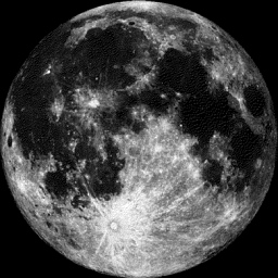
Moon Phase for July 13th at Midnight
2.5 Days Before Last Quarter
2.5 Days Before Last Quarter
_________________________
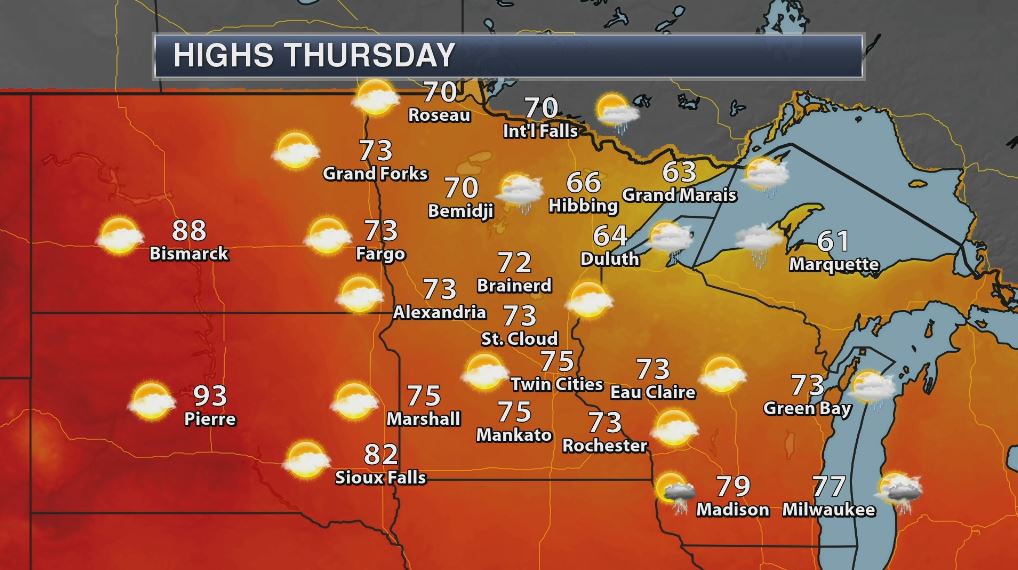
Weather Outlook For Thursday
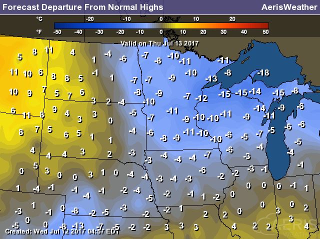
High temperatures on Thursday will be quite cool for July with many locations not warming out of the 70s. In fact, some locations across the Arrowhead and northern Wisconsin may not even get out of the 60s! Temps on Thursday will be running a good 10F to 15F below average.
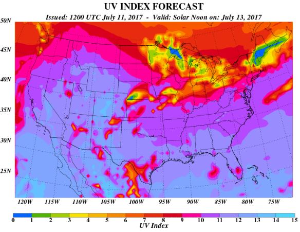
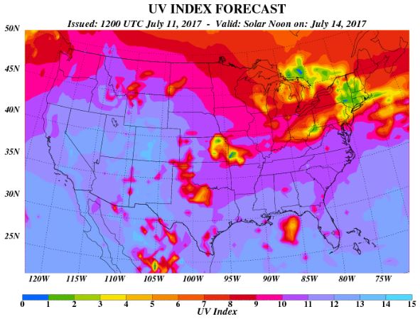
UV Index for Thursday - HIGH
The UV Index will be considered HIGH across much of the state of Minnesota on Thursday, which means that it will only 15 to 20 minutes or less to burn unprotected skin. With that said, if you are planning on spending any extended length of time outside, make sure you wear appropriate attire and lather on the sun block!
__________________________________________________________________________
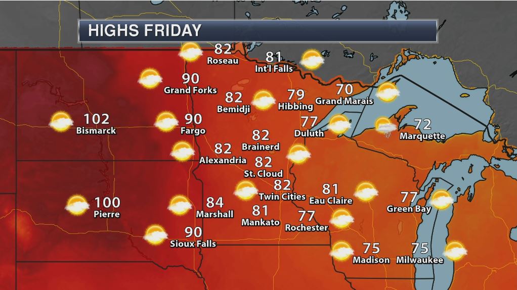
Weather Outlook For Friday
Temperatures on Friday will be back to if not even a little above average with many locations warming into the 80s to near 90F. However, slightly cooler than average reading will still be found in the far eastern part of Minnesota and across parts of Wisconsin with readings still stuck in the 70s.
UV Index for Friday - HIGH
The UV Index for Friday is expected to be VERY HIGH once again, which means that your skin could burn in 15 to 20 minutes or less!
_____________________________________________________________
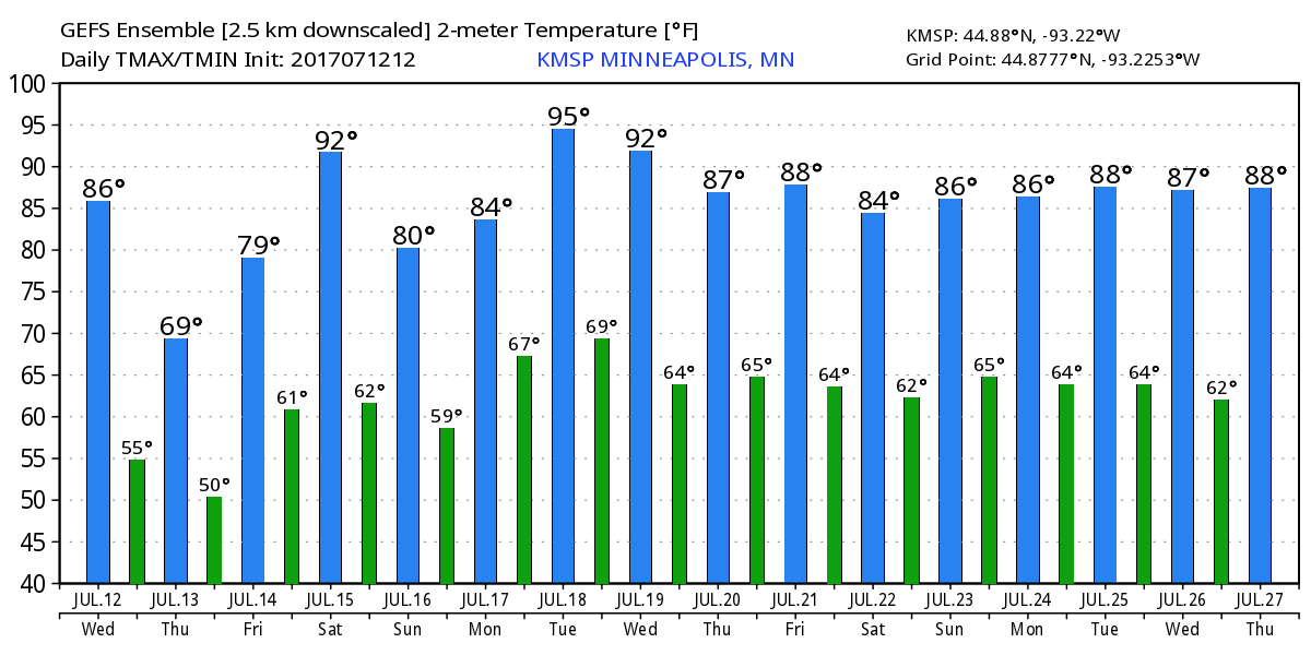
Temperature Outlook
Here's the temperature outlook through July 27th, which shows a very brief cool down on Thursday, but we should already be back in the heat and humidity by the weekend. The extended outlook suggests a string of warm temps developing through much of next week and into the 4th full week of July.
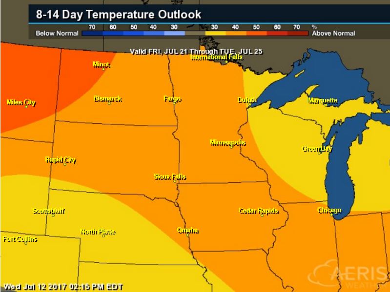
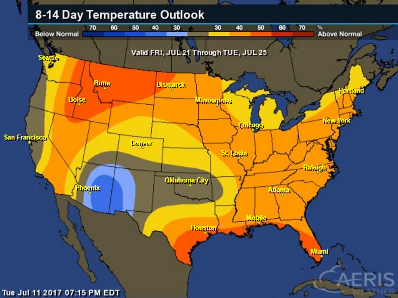
8 to 14 Day Temperature Outlook
According to NOAA's CPC, the extended temperature outlook from July 21st to July 25th suggests warmer than average temperatures continuing across much of the Upper Midwest.. The second half of the month could be quite steamy. Stay tuned...
___________________________________________________________
Extended Temperature Outlook
According to NOAA's CPC, the extended temperature outlook through July 25th shows much of the nation will be dealing with above normal temperatures into the second half of the month. The only cooler than average spot maybe located across parts of the Southwestern US.
____________________________________________________________
Weather Outlook This Week
The weather outlook over the next couple of days shows stormy weather continuing across parts of the Central US and into the Northeast. Some of the storms could strong to severe with locally heavy rains. There will also be locally heavy rain across the Desert Southwest.
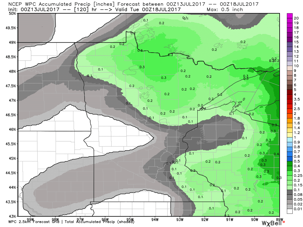
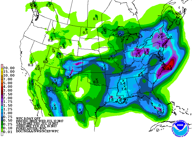
5 Day Precipitation Outlook
According to NOAA's WPC, the next several days could produce areas of locally heavy rainfall across parts of the Ohio Valley and East Coast. These particular areas could see nearly 1" to 3"+ inches through early next week. There may also be a few pocket of heavy rain along the Gulf Coast and in the Desert Southwest.
___________________________________________________________________
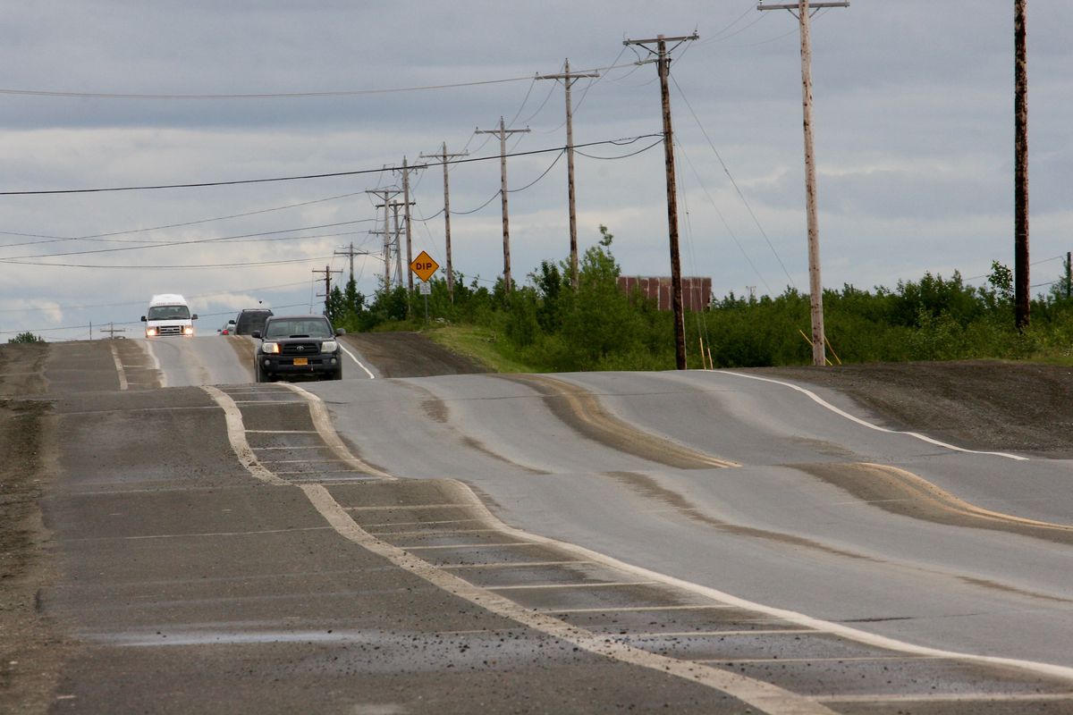
"‘The permafrost is dying’: Bethel sees increased shifting of roads and buildings"
"Along the main thoroughfare here, drivers brake for warped asphalt. Houses sink unevenly into the ground. Walls crack and doors stick. Utility poles tilt, sometimes at alarming angles. Permafrost in and around Bethel is deteriorating and shrinking, even more quickly than most places in Alaska. Since the first buildings out here, people have struggled with the freeze and thaw of the soils above the permafrost. Now those challenges are amplified. "What they are saying is the permafrost is dying," said Eric Whitney, a home inspector and energy auditor in Bethel who has noticed newly eroding river banks, slanting spruce trees and homes shifting anew just weeks after being made level. "I'm just assuming it is not coming back while we're around here.""
(Chief Eddie Hoffman Highway, seen on June 28, is the main thoroughfare in Bethel, and one of few paved roads. It has become a roller coaster of a ride over the past couple of years. The state Department of Transportation is studying whether heaving from the thaw-freeze of permafrost is a factor. (Lisa Demer / Alaska Dispatch News))
_______________________________________________________________
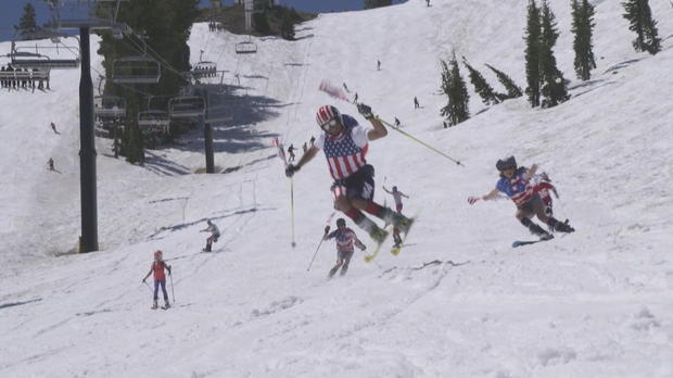
"Rare Calif. summer snowpack fun for skiers--but spawning raging waters downstream"
"Ski lifts ran on Independence Day at Squaw Valley Resort for the fourth time in history. But as the winter's record-breaking snow melts, it's creating raging rivers downstream where dozens of people have already been rescued from the Truckee River. In the High Sierra of California, it's continuing to look a lot like Christmas -- but in July. Two weeks after the official start of summer, skiers at Squaw Valley are refusing to let temperatures near 80 degrees melt away their favorite winter sport, reports CBS News correspondent Carter Evans."
(Skier on July 4 at Squaw Valley Resort in California. Credit: CBS NEWS)
"Aurora time-lapse video dazzles from space"
Being an astronaut on the International Space Station has its perks, including a front row seat to a light show most people will only ever see from the planet's surface. NASA released a time-lapse video on Friday showing a June 25 aurora filmed by a camera on the ISS.

________________________________________________________________
"Florida woman struck by lightning, then gives birth"
A 26-year-old Florida woman was struck by lightning Thursday then gave birth to a baby boy. Meghan Davidson was in a gated community in Fort Myers as a series of heavy storms moved through the area. The lightning strike occurred about 4:30 p.m. First responders found Davidson on the ground when they arrived. She was then taken to a local hospital. South Florida television station NBC 2 reported Davidson was a week away from her due date when the strike occurred, prompting doctors to deliver the baby, Owen. Davidson was in critical condition on Friday. On Monday, she was upgraded to serious condition. The hospital did not provide information on Owen.
(Photo: Lukasz Ogrodowczyk, European Pressphoto Agency)
__________________________________________________________
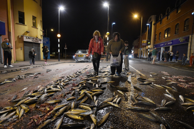
"5 Weird But Real Weather Events"
We don’t remember most of the weather we experience on a daily basis. Even hardcore weather geeks are hard-pressed to recall many events beyond what reporters would cover on the news. But there are some atmospheric tantrums that are memorable because of how bizarre they are. Here are some true-yet-bizarre weather phenomena that you'd be sure to remember if you ever got to experience them firsthand.
(This scene was caused by a tanker full of mackerel spilling on a Belfast street in 2015, but a fish rain might look similar. Image Credit: CHARLES MCQUILLAN/GETTY IMAGES)
________________________________________________________________
"Don’t rely on sunscreen alone this summer"
"Sunscreen is important for protecting your skin from the sun, but it shouldn't be the only thing you use. It’s that glorious time of year when the sun is hot, the days are long, and the outdoors beckons. From balcony to backyard to beach, many of us are happy to soak up the delicious rays that have felt so long in coming. The sunlight may feel wonderful, but it’s not entirely harmless. Too much time in the sun can result in bad sunburns, which are linked to skin cancers – mostly carcinomas, but also much deadlier melanomas. While sunscreens can help reduce the risk of skin cancer, they are not a perfect solution: To be most effective, sunscreens should be paired with other sun-savvy measures. The Environmental Working Group (EWG) urges people to understand how sunscreen works (read: why some brands are much better than others) and to think of it as “just one tool in your arsenal.”"
(Image Credit: Promo image EWG via TreeHugger.com)

_____________________________________________________________
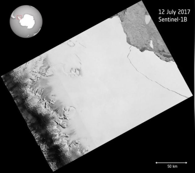
"Giant iceberg breaks off Antarctica"
"One of the biggest icebergs on record has broken away from Antarctica, scientists said on Wednesday, creating an extra hazard for ships around the continent as it breaks up. The one trillion tonne iceberg, measuring 5,800 square km, calved away from the Larsen C Ice Shelf in Antarctica sometime between July 10 and 12, said scientists at the University of Swansea and the British Antarctic Survey. The iceberg has been close to breaking off for a few months. Throughout the Antarctic winter, scientists monitored the progress of the rift in the ice shelf using the European Space Agency satellites. "The iceberg is one of the largest recorded and its future progress is difficult to predict," said Adrian Luckman, professor at Swansea University and lead investigator of Project MIDAS, which has been monitoring the ice shelf for years."
(The one trillion tonne iceberg, measuring 5,800 square km, calved away from the Larsen C Ice Shelf in Antarctica, in an image taken July 12, 2017.)
______________________________________________________________________
Thanks for checking in and don't forget to follow me on Twitter @TNelsonWX

No comments:
Post a Comment