81st Anniversary of the All-Time Record High of 108F in the Twin Cities - July 14, 1936
Friday, July 14th, 2017 marks the 81st anniversary of the All-Time Record High of 108F set in the Twin Cities on July 14th, 1936... 1936 was a remarkable year in the Twin Cities as there were 9 days that the temperature reached 100F or better; a record that still stands today! Remarkably, July 1936 had 8 days with highs above 100F and from July, 10th to July 12th, the high temperature was at 106F or warmer each of those days - WOW! Here's an excerpt from MN DNR about July 1936: "July 1936 is also the hottest month ever recorded in the Twin Cities, with an average temperature at a very warm 81.4 degrees. In addition to the heat, only 0.11 inches of precipitation fell, making this the driest July as well. The Dust Bowl Era produced many record hot temperatures in the Twin Cities, including the only 100 degree day observed in May."
(Cooling a Car in the 1930s - Courtesy: Minnesota Historical Society)

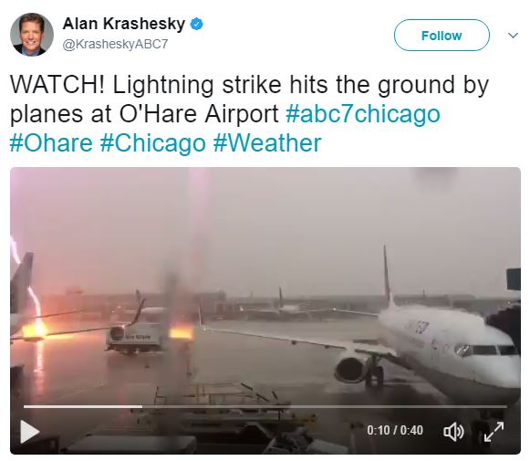
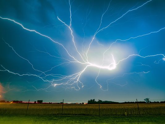
Lightning Strike Hits Ground By Planes at O'Hare Airport in Chicago
WOW! This is crazy... Alan Krashesky @KrasheskyABC7 tweeted this on Wednesday. Talk about a close call - YIKES!
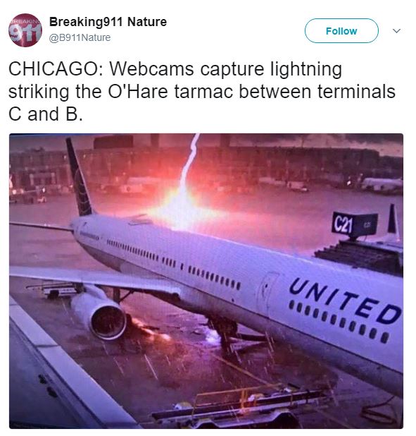
Here's another tweeted image from @B911Nature
_______________________________________________________________
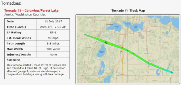
EF-1 Tornado Confirmed in Columbus/Forest Lake
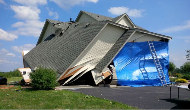
The storms that produced widespread wind damage early Wednesday morning was a result of straight-line winds and even a tornado. Here's a little more from the Twin Cities National Weather Service.
"During the early morning hours of July 12th, a line of severe storms tracked from central Minnesota into western Wisconsin. This line of storms created widespread damaging straight line winds across Anoka and northern Washington Counties in eastern Minnesota, with the damaging winds continuing into northwest St. Croix and southwestern Polk counties in western Wisconsin. Within this broad swath of damaging winds, a concentrated path of more significant damage was found in the Forest Lake area that was determined to be associated with a tornado."
The National Weather Service conducted a storm survey Wednesday afternoon and determined that the tornado in Columbus/Forest Lake was an EF-1 with etimated peak winds of 90mph. The path length was 8.8 miles with a max width of 300 yards, which formed at 2:28 AM - 2:37 AM.
"This tornado started 6 miles WSW of Forest Lake and tracked to 4 miles NE of Hugo. It caused an attached garage to collapse and destroyed a couple of out buildings, along with tree damage."
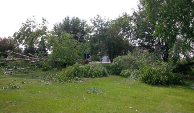
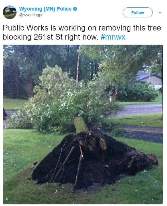
Thanks to the Wyoming Police Department for the image below where severe thunderstorms blasted through early Wednesday morning and created a lot of wind damage. The police department there tweeted quite a few photos of downed trees and even power lines.
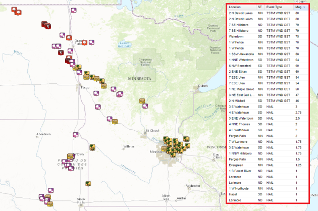
The storm report map from PM Tuesday to AM Wednesday shows quite a bit of wind damage reports on the north and eastern side of the Twin Cities Metro, while a number of large hail, damaging wind and even tornado reports across the eastern Dakotas and western Minnesota.
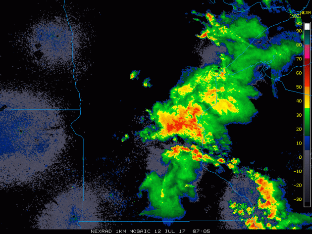
Tuesday Night/AM Wednesday Radar
The radar loop from overnight Tuesday into early Wednesday morning showed a very large cluster of storms pushing through the region. Some of these storms were severe with damaging winds and locally heavy rainfall.
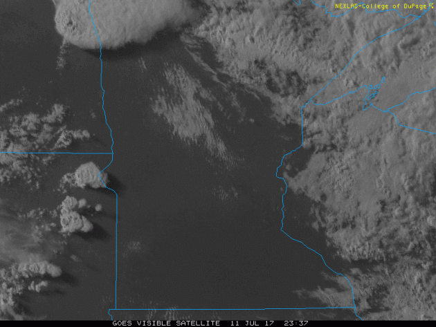
Visible Satellite From PM Tuesday
The visible satellite image from PM Tuesday/AM Wednesday shows explosive thunderstorms developing along the Dakota/Minnesota border late in the day. These thunderstorms developed very quickly in what was a very unstable atmosphere on Tuesday, which went on to produce large hail, damaging winds and even tornadoes!
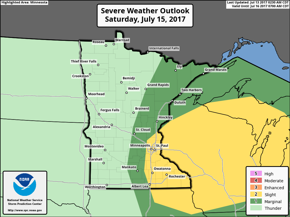
After a much cooler, less humid and quieter day across the region Thursday, weather conditions will once again be heating up and turning more unsettled as we approach the weekend. According to NOAA's SPC, there is a risk for isolated strong storms across parts of northwestern MN on Friday and a risk of isolated strong to severe storms across parts of eastern and especially southeastern Minnesota on Saturday. Stay tuned for more...
.png)
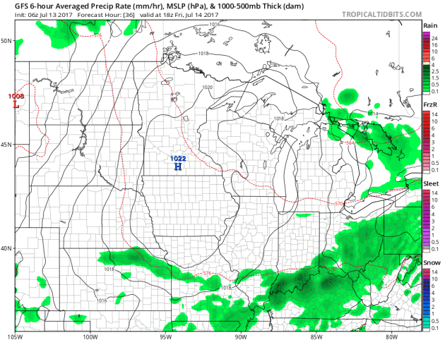
Simulated Radar
The simulated radar from midday Friday to midday Sunday suggests slightly more unsettled weather moving in late Friday through Saturday night across the region. Note that some of these storms could get a little aggressive in a few spots, but the threat doesn't appear to be very widespread across Minnesota.
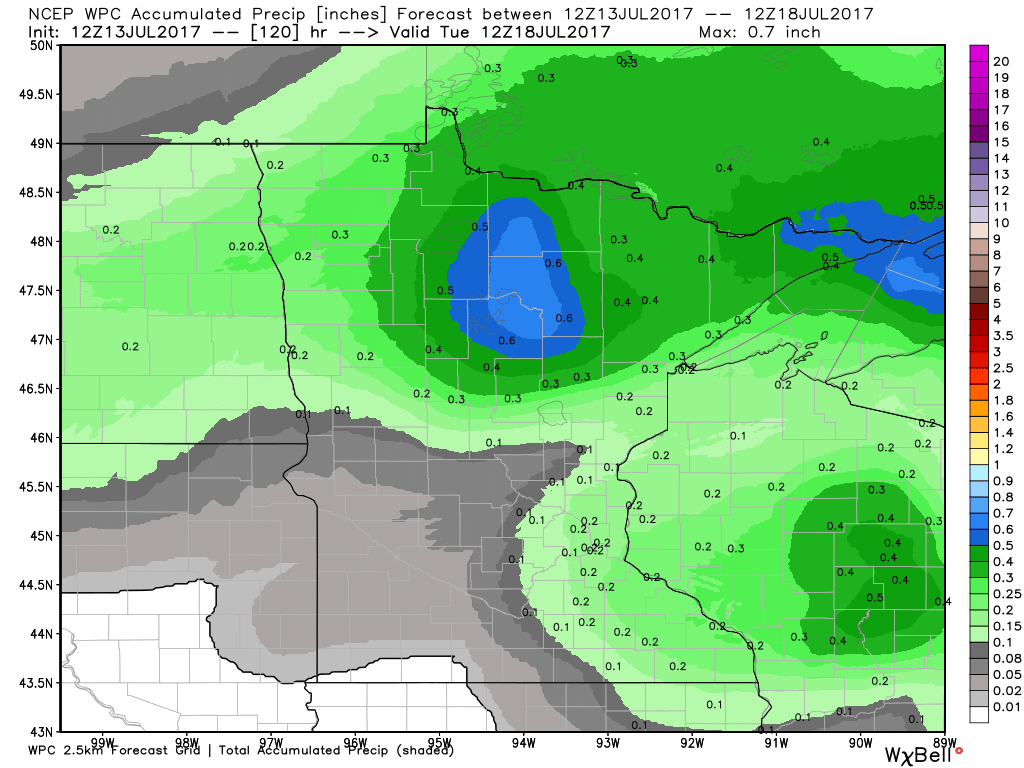
The extended forecast through AM Tuesday suggets pockets of heavier rain potential across northern Minnesota. There may also be a little rain across parts of southeastern Minnesota, but some locations may also stay completely dry during through early next week. It might not be a bad idea to water your lawns and gardens generously over the next few days.
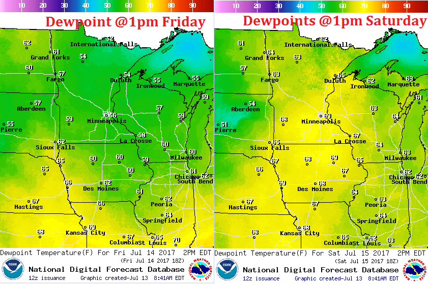
Getting Muggy Again By Saturday
After a much cooler and less humid day on Thursday, dewpoints will still be fairly comforable on Friday. Enjoy it because hot and sweaty weather will return on Saturday as dewpoints climb into the upper 60s to near 70F across the state. With highs approaching 90F and dewpoints as high as they'll be, it may feel more like the mid 90s in spots Saturday afternoon. WHEW!
___________________________________________________________________________
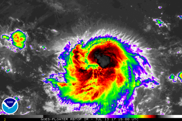
FERNANDA in the Eastern Pacific
The National Hurricane Center continues to track FERNANDA, which as of lateThursday was a category 1 hurricane with 80mph sustained winds. FERNANDA is the 6th named storm of the 2017 Eastern Pacific Hurricane Season and the 3rd hurricane of the season behind DORA & EUGENE.
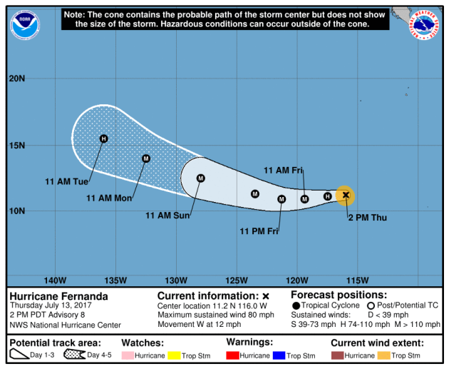
Here's the official track for FERNANDA, which has it becoming a major hurricane by the end of the week and if it does, it will become the 1st major hurricane of the season. The good news is that the forecast track has it continuing to drift west away from any major landmass.
Here's an interesting image. This is the forecast from a number of different models regarding the potential strength of FERNANDA over time. Note that the models have this ranging from category 1 strength to a potential category 4 hurricane. That is a major spread in models... Stay tuned to see what happens.

Eastern Pacific Outlook: Next 5 Days
Weather conditions in the Eastern Pacific continue to remain active as NOAA's NHC is keeping an eye on another wave of energy east of FERNANDA that has a low probability of tropical development over the next 5 days. Stay tuned...
.png)
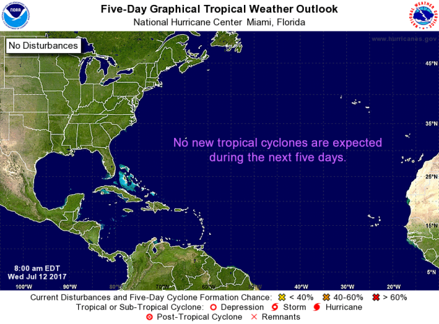
Meanwhile, the Atlantic basin looks fairly quiet with no tropical activity expected over the next 5 days. Stay tuned...
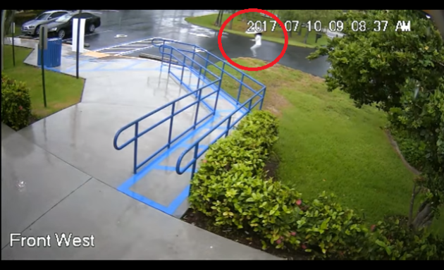
The Broward County Sheriff’s Office is reporting a swim instructor and lifeguard was jolted by a lightning strike that hit a nearby concrete pole Monday morning. According to sheriff spokesman Mike Jachles, the 27-year-old woman was about 300 feet from the pole when the lightning struck. She was taken to Florida Medical Center where she was treated and released.
See the video from PalmBeachPost.com HERE:
 _______________________________________________________________________2017 Lightning Fatalities
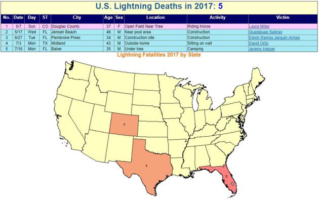
According to NOAA's NWS, there have been 5 lightning fatalities so far this year. Note that 3 of those deaths have occurred in Florida, which is considered to be the lightning capital of the United States.
 Lightning Deaths Over the Last 10 Years
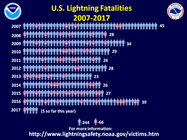
According to NOAA's NWS, lightning kills an average of 47 people each year in United States! Over the last 10 years, 310 people have died from lightning and what is interesting is that nearly 79% have been males!
 Lightning Safety: Myths & Facts
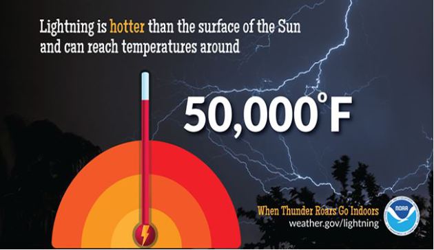
Did you know that lightning is nearly 5 times hotter than the surface of the sun? Here are a few interesting myths and facts from NOAA's NWS regarding lightning:
Lightning Safety: Myths & Facts
Did you know that lightning is nearly 5 times hotter than the surface of the sun? Here are a few interesting myths and facts from NOAA's NWS regarding lightning:
Myth: If you're caught outside during a thunderstorm, you should crouch down to reduce your risk of being struck.
Fact: Crouching doesn't make you any safer outdoors. Run to a substantial building or hard topped vehicle. If you are too far to run to one of these options, you have no good alternative. You are NOT safe anywhere outdoors. See our safety page for tips that may slightly reduce your risk.
Myth: Lightning never strikes the same place twice.
Fact: Lightning often strikes the same place repeatedly, especially if it's a tall, pointy, isolated object. The Empire State Building is hit an average of 23 times a year
Myth: If it’s not raining or there aren’t clouds overhead, you’re safe from lightning.
Fact: Lightning often strikes more than three miles from the center of the thunderstorm, far outside the rain or thunderstorm cloud. “Bolts from the blue” can strike 10-15 miles from the thunderstorm.
Myth: Rubber tires on a car protect you from lightning by insulating you from the ground.
Fact: Most cars are safe from lightning, but it is the metal roof and metal sides that protect you, NOT the rubber tires. Remember, convertibles, motorcycles, bicycles, open-shelled outdoor recreational vehicles and cars with fiberglass shells offer no protection from lightning. When lightning strikes a vehicle, it goes through the metal frame into the ground. Don't lean on doors during a thunderstorm.
Myth: A lightning victim is electrified. If you touch them, you’ll be electrocuted.
Fact: The human body does not store electricity. It is perfectly safe to touch a lightning victim to give them first aid. This is the most chilling of lightning Myths. Imagine if someone died because people were afraid to give CPR!
Myth: If outside in a thunderstorm, you should seek shelter under a tree to stay dry.
Fact: Being underneath a tree is the second leading cause of lightning casualties. Better to get wet than fried!
See more on lightning including safety tips HERE:
 ___________________________________________________________________________
National Weather Hazards Ahead...
See the video from PalmBeachPost.com HERE:
According to NOAA's NWS, there have been 5 lightning fatalities so far this year. Note that 3 of those deaths have occurred in Florida, which is considered to be the lightning capital of the United States.
According to NOAA's NWS, lightning kills an average of 47 people each year in United States! Over the last 10 years, 310 people have died from lightning and what is interesting is that nearly 79% have been males!
Myth: If you're caught outside during a thunderstorm, you should crouch down to reduce your risk of being struck.
Fact: Crouching doesn't make you any safer outdoors. Run to a substantial building or hard topped vehicle. If you are too far to run to one of these options, you have no good alternative. You are NOT safe anywhere outdoors. See our safety page for tips that may slightly reduce your risk.
Myth: Lightning never strikes the same place twice.
Fact: Lightning often strikes the same place repeatedly, especially if it's a tall, pointy, isolated object. The Empire State Building is hit an average of 23 times a year
Myth: If it’s not raining or there aren’t clouds overhead, you’re safe from lightning.
Fact: Lightning often strikes more than three miles from the center of the thunderstorm, far outside the rain or thunderstorm cloud. “Bolts from the blue” can strike 10-15 miles from the thunderstorm.
Myth: Rubber tires on a car protect you from lightning by insulating you from the ground.
Fact: Most cars are safe from lightning, but it is the metal roof and metal sides that protect you, NOT the rubber tires. Remember, convertibles, motorcycles, bicycles, open-shelled outdoor recreational vehicles and cars with fiberglass shells offer no protection from lightning. When lightning strikes a vehicle, it goes through the metal frame into the ground. Don't lean on doors during a thunderstorm.
Myth: A lightning victim is electrified. If you touch them, you’ll be electrocuted.
Fact: The human body does not store electricity. It is perfectly safe to touch a lightning victim to give them first aid. This is the most chilling of lightning Myths. Imagine if someone died because people were afraid to give CPR!
Myth: If outside in a thunderstorm, you should seek shelter under a tree to stay dry.
Fact: Being underneath a tree is the second leading cause of lightning casualties. Better to get wet than fried!
See more on lightning including safety tips HERE:
PRELIMINARY 2017 Tornado Map
It certainly has been a fairly active first half of 2017 with 1157 preliminary tornado reports through July 10th. Note that this is the most tornadoes through July 11th since 2011, when there were nearly 1,600 reports. The map below shows the distribution of the tornadoes so far this year.
.gif) PRELIMINARY 2017 Tornado Count
PRELIMINARY 2017 Tornado Count
According to NOAA's SPC, the PRELIMINARY 2017 tornado count is 1161 (through July 12). Note that is the most active year for tornadoes since 2011, when there were 1,626 tornadoes. Keep in mind there was a major tornado outbreak in the Gulf Coast region from April 25-28, 2011 that spawned nearly 500 tornadoes, some of which were deadly. That outbreak is known as the Super Outbreak of 2011 and has gone down in history as one of the biggest, costliest and one of the deadliest tornado outbreaks in history.
.png)
____________________________________________________________
According to NOAA's SPC, the PRELIMINARY 2017 tornado count is 1161 (through July 12). Note that is the most active year for tornadoes since 2011, when there were 1,626 tornadoes. Keep in mind there was a major tornado outbreak in the Gulf Coast region from April 25-28, 2011 that spawned nearly 500 tornadoes, some of which were deadly. That outbreak is known as the Super Outbreak of 2011 and has gone down in history as one of the biggest, costliest and one of the deadliest tornado outbreaks in history.
____________________________________________________________
2.) Heavy rain across portions of the Great Lakes and the Upper Mississippi Valley, Tue-Thu, Jul 18-Jul 20.
3.) Excessive heat across portions of the central and northern Plains, the Mississippi Valley, the Tennessee Valley, the Great Lakes, and the Ohio Valley, Tue-Thu, Jul 18-Jul 20.
4.) Much above-normal temperatures across portions of the central and northern Plains, the northern Rockies, the Middle and Upper Mississippi Valley, and the Northern Great Basin, Sun-Wed, Jul 16-Jul 19.
5.) Flooding possible across portions of the central and southern Rockies, the central Great Basin, and the Southwest, Sun-Thu, Jul 16-20.
6.) Flooding possible across portions of the Great Lakees and the Ohio Valley.
7.) Flooding occurring or imminent across portions of the Great Lakes and the Ohio Valley.
8.) Flooding possible across portions of the Central Rockies, the Central Great Basin, and the Southwest, Fri-Thu, Jul 21-27.
9.) Slight risk of much above-normal temperatures for portions of the Plains, the central and northern Great Basin, the northern and central Rockies, the Mississippi Valley, California, and the Pacific Northwest, Fri-Thu, Jul 21-Jul 27.
10.) Severe Drought across California, Hawaii, the Northern Plains, and the Southwest.
.png)
_________________________________________________________
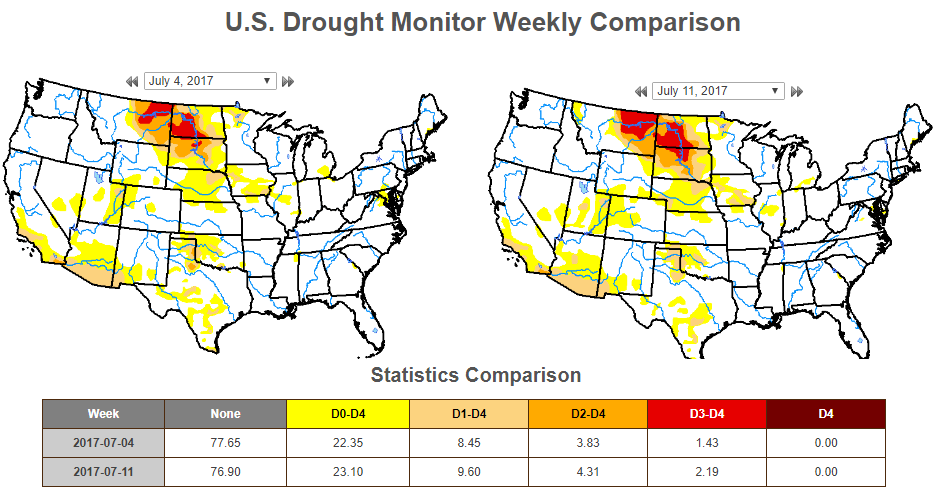
US Drought Monitor
According to the US Drought Monitor, drought conditions from July 4h to July 11th worsened slightly across the nation. Note that EXTREME drought conditions (located across parts of Montana and parts of North and South Dakota increased from 1.43% last week to 2.19% this week.
_________________________________________________________________________
National Weather Outlook
Here's the weather outlook through early next week, which shows showers and storms moving into the eastern part of the country through the end of the week and early weekend time frame. Spotty strong to severe storms and locally heavy rainfall could be found there, while monsoonal storms and locally heavy rains will be found in the Desert Southwest. As we head into the weekend and early next week, it appears that more unsettled weather and heavy rain potential will be moving back into parts of the Midwest.
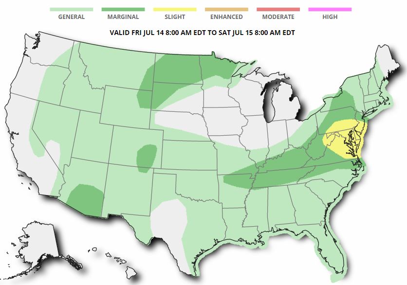
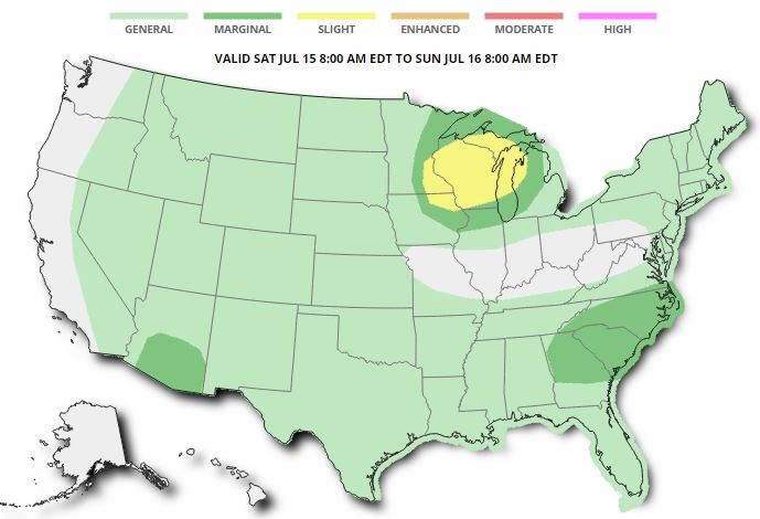
Severe Threats Friday and Saturday
Here are the severe weather concerns for Friday and Saturday from NOAA's SPC. Note that a few isolated strong storms could be found in the Southwest, eastern Colorado and across the High Plains, while the best potential of severe weather looks to be centered near Washington DC on Friday afternoon/evening. As we head into Saturday the best potential for strong to severe storms will shift east into the Upper Midwest/Western Great Lakes region, while a few strong storms could be found in the Mid-Atlantic and again in the Southwest.
Excessive Rainfall Potential Friday & Saturday
According to NOAA's WPC, there is a risk of excessive rain on Friday & Saturday with the best chance of heavier rain across parts of West Virgina on Friday.
.gif)
.gif)
With excessive rainfall potential in place over parts of the Ohio Valley, Northeast and Mid-Atlantic on Friday and Saturday, some spots could see more than 1" to 2"+ of rain. This heavy rain threat could lead to isolated areas of flooding!
________________________________________________________
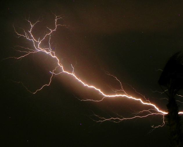
Monsoonal Storms
Thanks to my good friend Rich Koivisto from Bullhead City, AZ, who captured this impressive lightning strike during some monsoonal thunderstorms late last weekend! According to NOAA's NWS, the monsoon season was considered to have started when there were 3 three consecutive days of average dewpoint temperatures of 55 degrees or higher. That was the definition/protocol through the year 2007, but in 2008, the NWS decided to declare June 15th to September 30th the official monsoon season in Arizona. Pretty neat!
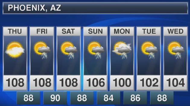
Monsoonal Storms Continue
Sure it'll be hot in Phoenix, AZ over the next few days, but look at the cooling trend as we head into early next week. A high of 100F on Monday, wow... what a relief! Keep in mind that the average high in Phoenix at this time of the year is 107F. Also note the continued thunderstorm chances, these are daily monsoon thunderstorm chances that could bring heavy pockets of rain to localized areas through next week.
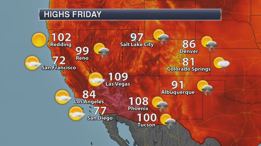
High Temps in the Southwest on Friday
Summertime heat in the Desert Southwest often brings widespread 90F and 100F+ high temperatures on a daily basis. This heat also helps in the formation of monsoonal storms that can develop on a daily basis across the region as well. Here are the high temperatures expected across the region on Friday, which look to be a little above average in spots west of the Four Corners Region.
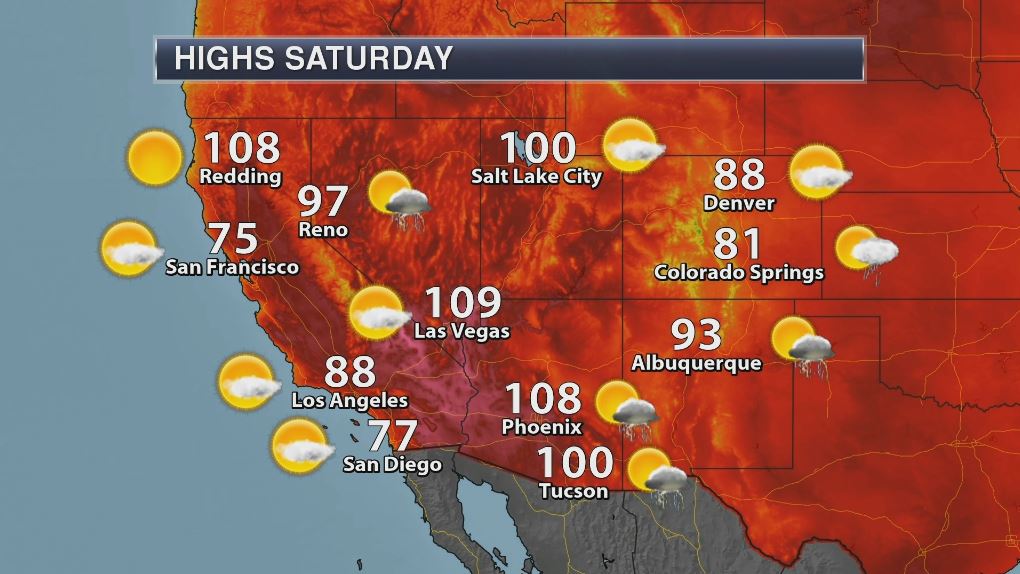
High Temperatures on Saturday
The heat will continue to build west of the Four Corners Region on Saturday with some locations nearly 10F above average. With this next surge of hot and dry weather building into the region, the fire danger threat is expected to increase as well.
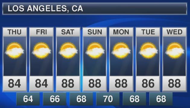
Los Angeles, CA
With temperatures on the upswing across parts of the Southwest through the end of the week and weekend ahead, places like Los Angeles, CA could once again see highs in the 90s! Here's the extended forecast through the middle part of next week, which shows near 90F highs from Saturday to Wednesday. WHEW!
Death Valley, CA
High temperatures in Death Valley, CA will also be quite hot. Note that high temperatures will be around 120F or more through the middle of next week. There may even be a chance for an isolated monsoon storm Sunday and Monday.

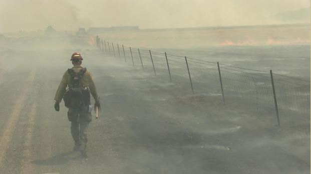
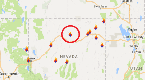
Rooster Comb Fire - Battle Mountain, Nevada
According to Inciweb, one of the largest fires currently burning in the Lower 48 is the Rooster Comb Fire located near Battle Mountain, NV. This particular fire has consumed a whopping 222,000 acres and is 53% contained. This particular fire started on Sunday, July 9th and quickly spread as hot, dry and windy weather created extreme fire behavior. An influx of new crews and equipment have been checking in and there are currently 828 people working on the fire. The estimated containment date is projected for Monday, July 17th.
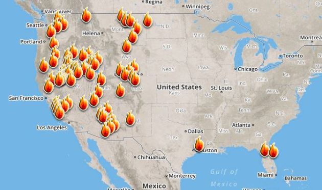
Ongoing Large Wildfires
Here's a look at the current wildfire map across the country. Recent hot and dry weather has helped to spark several wildfires across the Western US, while a few have also been popping up in the Eastern US.
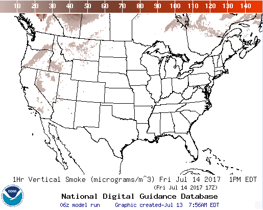
National Smoke Analysis
Here's the projected wildfire smoke concentration for midday Friday. Note that much of the smoke from the western wildfires will be mainly confined to the Western US. If you are in these areas, air quality could be quite poor, but these areas may also be enjoying very interesting looking sunrises/sunsets, which tend to look hazy or reddish-orange.
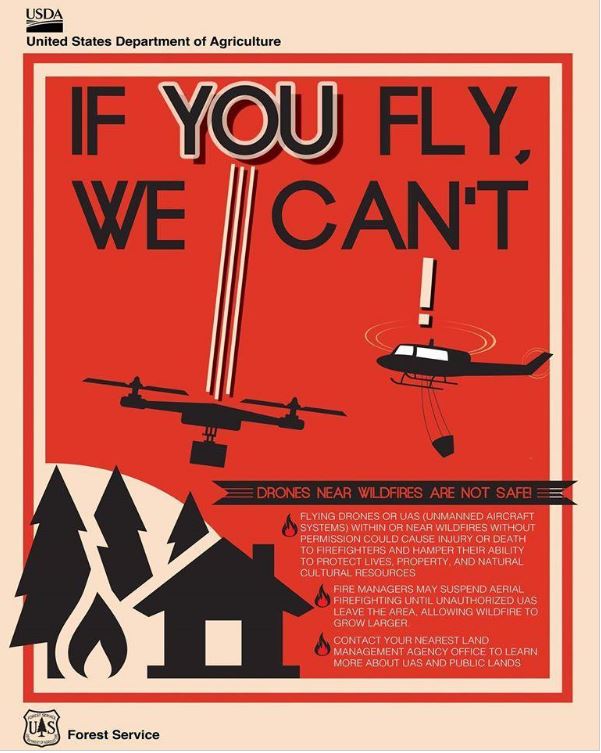
Here's an interesting story regarding drones causing air support to be grounded during wildfires! Here's the latest from Fox 31 in Denver (KDVR): "Fire departments statewide are pleading with the public to follow the rules when it comes to drones around active wildfires. Flying high above the ground, drones give a bird’s-eye view of the world. From cityscapes to places off-limits to the public, they can soar into fires like never before. “We certainly see the benefit in fact South Metro is seeing a few people to get properly trained,” South Metro Fire Rescue spokesman Eric Hurst said. However, sometimes drones can also be a hazard for fire crews. On Saturday, South Metro was one of four agencies responding to a grass fire in Sedalia. The 18-acre fire required air support but couldn’t utilize it as planned. “During [Saturday’s] incident, one of our fire crews observed a drone flying around the scene, so that triggers a lot of concerns for us,” Hurst said. A drone in the immediate area of a wildfire makes conditions too unsafe for airplanes. If the two collide, it could cause the plane to crash. “The pilots don’t want to be up in the air when they can’t communicate with another aircraft that’s flying next to them,” Hurst said. A similar situation happened at the Lightner Creek Fire in Durango last week. Planes carrying fire retardant were forced to drop their loads early and leave the area because of an unauthorized drone in the flight path. “We don’t want any kind of an accident to happen so at that point, aircraft is going to have to be grounded until we can find out who’s operating the drone and we can get them to stop,” Hurst said."
 ________________________________________________________________________
81st Anniversary of the All-Time Record High: 108°
By Todd Nelson, filling in for Douglas
By Todd Nelson, filling in for Douglas
It was 81 years ago that the Twin Cities had their All-Time record high of 108 degrees. Good grief, that's hot!
1936 was an exceptional year and the Twin Cities fell victim to what was one of the most severe heat waves in U.S. history! The 1936 North American Heat Wave claimed the lives of thousands across the country, but 71 Minnesotans died on this date in 1936 due to the extreme heat. July 1936 will go down in history as the warmest and driest July ever recorded in the Twin Cities. Unreal...
No record setting temperatures are expected Friday. In fact, it'll be quite enjoyable with more sun, mild temps and low humidity. Hot and sweaty weather returns Saturday as readings bounce back into the lower 90s across southern Minnesota. This will also come with dewpoints near 70 degrees for some, which will make it feel more like the upper 90s! This quick surge in sticky weather could help to spark a late-day strong storm in eastern MN.
Sunday looks like a gem of a day as the humidity breaks a bit, but it gets muggy again next week.
______________________________________________________
______________________________________________________
Extended Forecast
FRIDAY: Comfy. More sun. Winds: N 5. High: 80.
FRIDAY NIGHT: Mostly clear and quiet. Winds: SSW 5. Low: 64.
SATURDAY: Hot & sticky. Spotty late day rumbles? Winds: WSW 5-10. High: 90
SUNDAY: Beautiful. Not quite as sticky. Winds: ESE 5-10. Wake-up: 66. High: 81.
MONDAY: Heating up! Storms arrive overnight. Winds: S 10-15. Wake-up: 62. High: 87.
TUESDAY: Unsettled. Scattered storms possible. Winds: SSW 5. Wake-up: 69. High: 90.
WEDNESDAY: Thundery downpour. Heavier in S. MN. Winds: NE 5-10. Wake-up: 67. High: 88.
THURSDAY: Looks drier. Not quite as muggy. Winds: E 5. Wake-up: 62. High: 83.
_______________________________________________________
_______________________________________________________
This Day in Weather History
July 14th
July 14th
2003: At least eleven tornadoes hit Minnesota. Baseball-sized hail is reported at Indus in Koochiching County.
1936: The all-time record high is reported in the Twin Cities, with 108 degrees at the downtown Minneapolis office. 71 people would die in the Twin Cities on this day due to the extreme heat.
1916: Heavy downpours at New Ulm dump over seven inches of rain in seven hours.
________________________________________________________
________________________________________________________
Average High/Low for Minneapolis
July 14th
July 14th
Average High: 84F (Record: 108F set in 1936)
Average Low: 64F (Record: 50F set in 1930)
Average Low: 64F (Record: 50F set in 1930)
Record Rainfall: 3.17" set in 1915
_________________________________________________________
_________________________________________________________
Sunrise/Sunset Times for Minneapolis
July 14th
July 14th
Sunrise: 5:40am
Sunset: 8:57pm
Sunset: 8:57pm
Hours of Daylight: 15hours & 17mins
Daylight LOST since yesterday: ~1 minute and 34 seconds
Daylight LOST since summer solstice (June 20th): ~20 minutes
__________________________________________________________
Daylight LOST since summer solstice (June 20th): ~20 minutes
__________________________________________________________
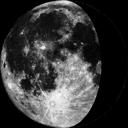
Moon Phase for July 14th at Midnight
1.5 Days Before Last Quarter
1.5 Days Before Last Quarter
_________________________
Weather Outlook For Friday
Friday looks like a really nice day with more sunshine, milder temps and low humidities. Highs will approach 80F in the Twin Cities, which will be a little closer to average, while highs in the western part of the state will near 90F by late afternoon. Note that readings will spike to near 100F in Bismarck, ND and Pierre, SD, which will be nearly 20F above average!

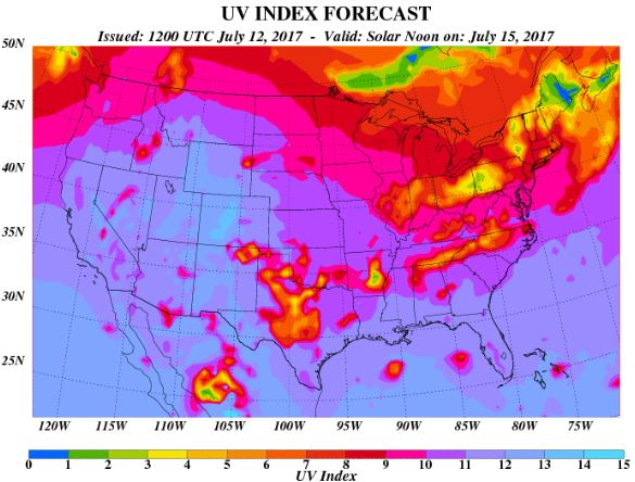
UV Index for Friday - VERY HIGH
The UV Index will be considered VERY HIGH across much of the state of Minnesota on Friday, which means that it will only 15 to 20 minutes or less to burn unprotected skin. With that said, if you are planning on spending any extended length of time outside, make sure you wear appropriate attire and lather on the sun block!

__________________________________________________________________________
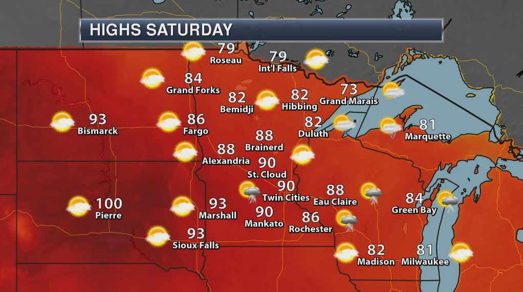
Weather Outlook For Saturday
The warm weather that was sitting across the Dakotas on Friday will start to move into the Upper Mississippi Valley on Saturday with highs across much of Minnesota nearly 5F to 10F above average. Note that many locations across the southern half of the state (including the Twin Cities) could warm to near 90F. With dewpoints approaching 70F for some, heat index values could approach 100F!

UV Index for Saturday - VERY HIGH
The UV Index for Saturday is expected to be VERY HIGH once again, which means that your skin could burn in 15 to 20 minutes or less!
_____________________________________________________________
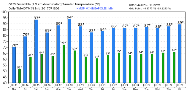
Temperature Outlook
Here's the temperature outlook through July 28th, which shows temperatures still a bit cooler than average on Friday, but the heat and humidity spikes on Saturday with additional heat spikes into next week. Climatologically speaking, this is the hottest time of the year, so this type of heat is pretty typical for mid July.
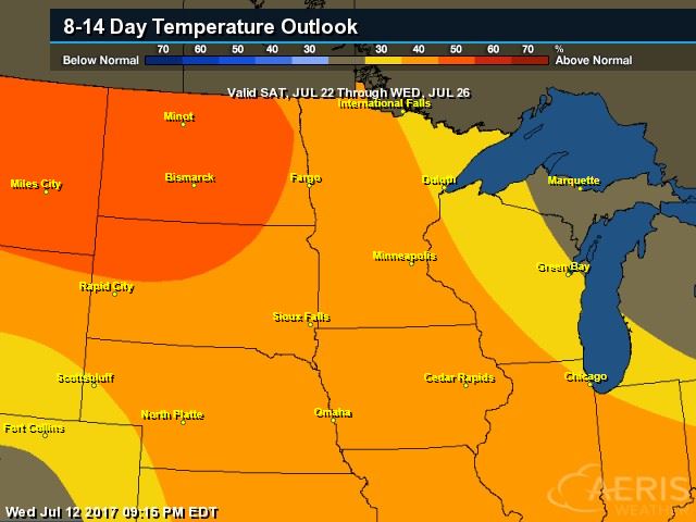
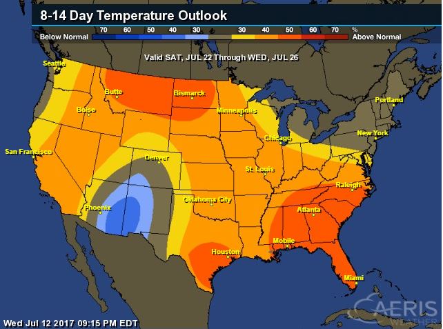
8 to 14 Day Temperature Outlook
According to NOAA's CPC, the extended temperature outlook from July 22nd to July 26th suggests warmer than average temperatures continuing across much of the Upper Midwest.. The second half of the month could be quite steamy. Stay tuned...
___________________________________________________________
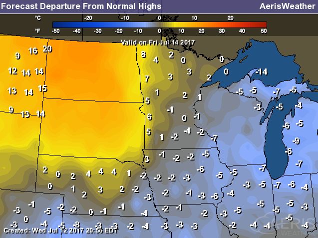
Extended Temperature Outlook
According to NOAA's CPC, the extended temperature outlook through July 26th shows much of the nation will be dealing with above normal temperatures into the second half of the month. The only cooler than average spot maybe located across parts of the Southwestern US.
____________________________________________________________
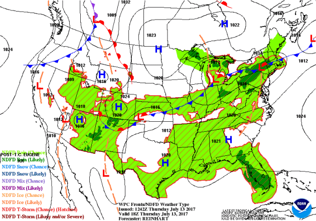
Weather Outlook This Week
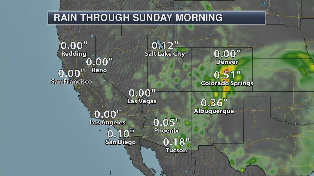
The weather outlook over the next couple of days shows stormy weather continuing across parts of the Central and Eastern US. Some of the storms could strong to severe with locally heavy rains. There will also be locally heavy rain across the Desert Southwest.
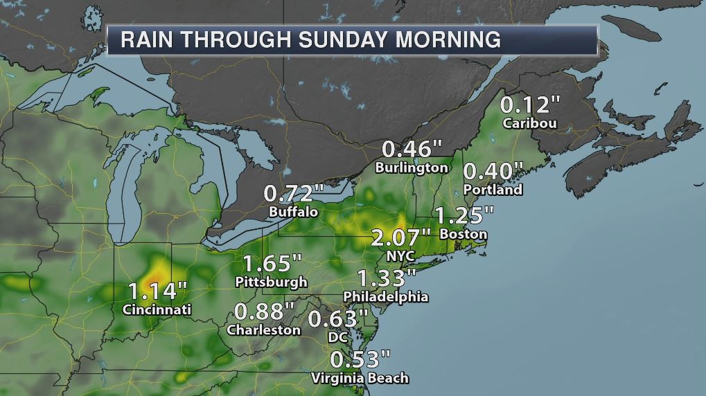
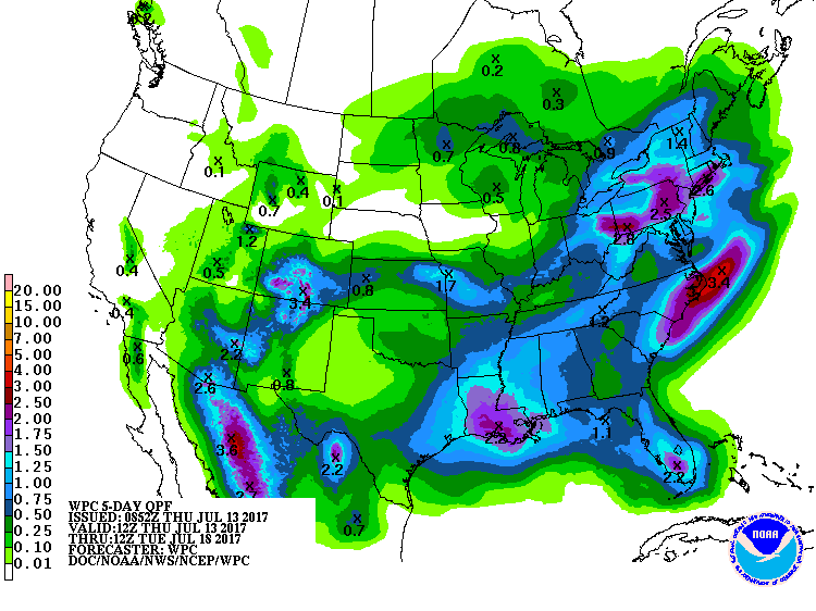
5 Day Precipitation Outlook
According to NOAA's WPC, the next several days could produce areas of locally heavy rainfall across parts of the Ohio Valley and East Coast. These particular areas could see nearly 1" to 3"+ inches through early next week. There may also be a few pocket of heavy rain along the Gulf Coast and in the Desert Southwest.
___________________________________________________________________
"First object teleported to Earth's orbit"
"Chinese researchers have teleported a photon from the Gobi desert to a satellite orbiting five hundred kilometres above the earth. This is achieved through quantum entanglement, a process where two particles react as one with no physical connection between them. Hooke Professor of Experimental Physics at Oxford University Ian Walmsley tells the World At One how quantum entanglement works and how teleportation could be utilised."
"Stop telling us to use ‘percent humidity.’ It’s terrible and here’s why"
"We get a lot of complaints about humidity. It is, after all, peak summer in D.C. — the nation’s swamp — which it turns out is hard to drain. Sometimes the complaints are about more than just the heavy feeling of sultry moisture and sticky clothes, though. Sometimes the air is so humid that people need more to complain about. Like maybe even the way we talk about humidity in general. There are just some temperatures at which nothing is good enough, you know? Specifically, some of our readers (and listeners) can’t stand that we don’t use “percent humidity.” You may be familiar with this metric from things like third-grade science lessons and the generic weather app on your phone. It’s really easy to understand — on a scale of 1 to 100, how humid is it? Except that’s not at all what percent humidity is describing. Key to this is the modifier to the term that’s often dropped in casual conversation: relative humidity. It’s relative to the temperature."
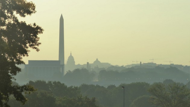
(A view of Washington. (George Jiang))
_________________________________________________________________________
"The Arctic Has Been Crazy Warm All Year. This Is What It Means for Sea Ice"
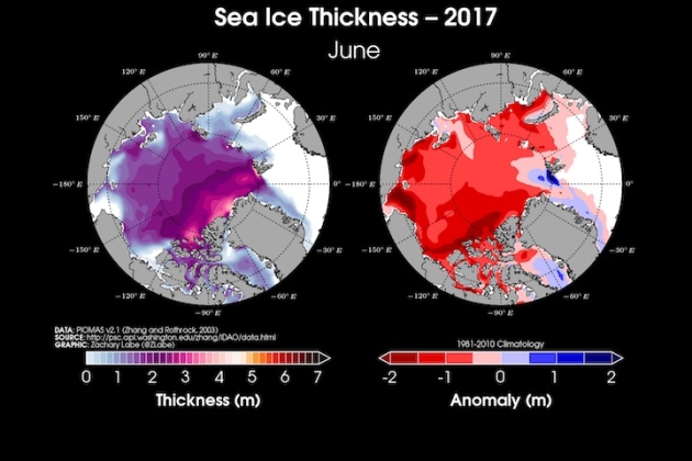
"Melt season has begun in earnest in the Arctic. Scientists will spend the next few months watching sea ice turn into open water until the ice pack hits its nadir in early fall. The vagaries of the weather and ocean currents will play a major role in determining where this year’s Arctic sea ice minimum ranks. But the steady drumbeat of climate change ensures that it will likely be among the lowest on record. New data from the National Snow and Ice Data Center show that sea ice extent was at its sixth-lowest mark for June. Sea ice was missing from 348,000 square miles of the Arctic Ocean, an area about three times the size of Arizona. After the string of record- or near-record low months late last year and early this year, the sixth-lowest extent might sound like an improvement. It’s not. As of July 2, sea ice extent was on par with 2012, a year that went on to set the mark for lowest Arctic sea ice minimum on record. That year, a major storm in August helped churn the ocean and smash ice to smithereens."
(Total Arctic sea ice thickness and its departure from normal for June. Credit: Zack Labe)
 _____________________________________________________________________
"Warming May Turn Africa’s Arid Sahel Green: Researchers"
"One of Africa's driest regions — the Sahel — could turn greener if the planet warms more than 2 degrees Celsius and triggers more frequent heavy rainfall, scientists said on Wednesday. The Sahel stretches coast to coast from Mauritania and Mali in the west to Sudan and Eritrea in the east, and skirts the southern edge of the Sahara desert. It is home to more than 100 million people. The region has seen worsening extreme weather — including more frequent droughts — in recent years. But if greenhouse gas emissions continue unabated, the resulting global warming — of more than 2 degrees Celsius above pre-industrial levels — could change major weather patterns in the Sahel, and in many different parts of the world, scientists say. Some weather models predict a small increase in rainfall for the Sahel, but there is a risk that the entire weather pattern will change by the end of the century, researchers at the Potsdam Institute for Climate Impact Research (PIK) said. "The sheer size of the possible change is mindboggling — this is one of the very few elements in the Earth system that we might witness tipping soon," said co-author Anders Levermann from PIK and the Lamont-Doherty Earth Observatory of New York's Columbia University."
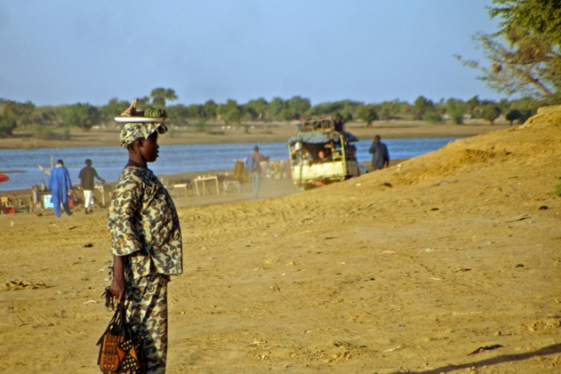
(The road to Djenne, on the Bani River in Mali. The Sahel region could turn greener if the planet warms more than 2 degrees Celsius. Credit: Carsten ten Brink/flickr)
 ______________________________________________________________________________
"EPA chief wants scientists to debate climate on TV"
"The U.S. Environmental Protection Agency is in the early stages of launching a debate about climate change that could air on television – challenging scientists to prove the widespread view that global warming is a serious threat, the head of the agency said. The move comes as the administration of President Donald Trump seeks to roll back a slew of Obama-era regulations limiting carbon dioxide emissions from fossil fuels, and begins a withdrawal from the Paris Climate Agreement - a global pact to stem planetary warming through emissions cuts. "There are lots of questions that have not been asked and answered (about climate change)," EPA Administrator Scott Pruitt told Reuters in an interview late on Monday."
(Environmental Protection Agency Administrator Scott Pruitt speaks during an interview for Reuters at his office in Washington, U.S., July 10, 2017.)

"Why scare tactics won't stop climate change"
"Some climate scientists are pushing back against a bleak portrayal of the coming climate apocalypse that was published Sunday night in New York magazine. The cover story’s vivid and doom-heavy forecast won’t help the fight against climate change, they argue. In fact, it’s possible these scare tactics could do just the opposite. The story, the “The Uninhabitable Earth,” trails the four horsemen as they thunder after runaway carbon emissions. Natural disasters could become so common that “we will just start calling them ‘weather,’” journalist David Wallace-Wells writes. New and long-dead viruses might emerge from thawing ice. Famine and mass migrations may fuel wars. And parts of the Earth could become almost uninhabitable by the end of the century."
(Photo by Kathryn Hansen/NASA)

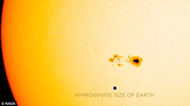
"A 75,000-mile-wide HOLE has appeared on the sun – and experts warn it could knock out communications satellites and cause blackouts on Earth"
"A huge spot has appeared on the sun that could send dangerous solar flares down to Earth. The sunspot, dubbed AR2665, is 74,560 miles (120,000 kilometres) wide – big enough to be seen from Earth. Experts have warned that the spot is large enough to produce 'M-class' solar flares, which can cause radio blackouts on Earth, knock out communications satellites and create radiation storms."
(CREDIT: NASA - This sunspot is the first to appear after the sun was spotless for 2 days. Like freckles on the face of the sun, they appear to be small features, but size is relative: The dark core of this sunspot is larger than Earth as shown by this graphic)
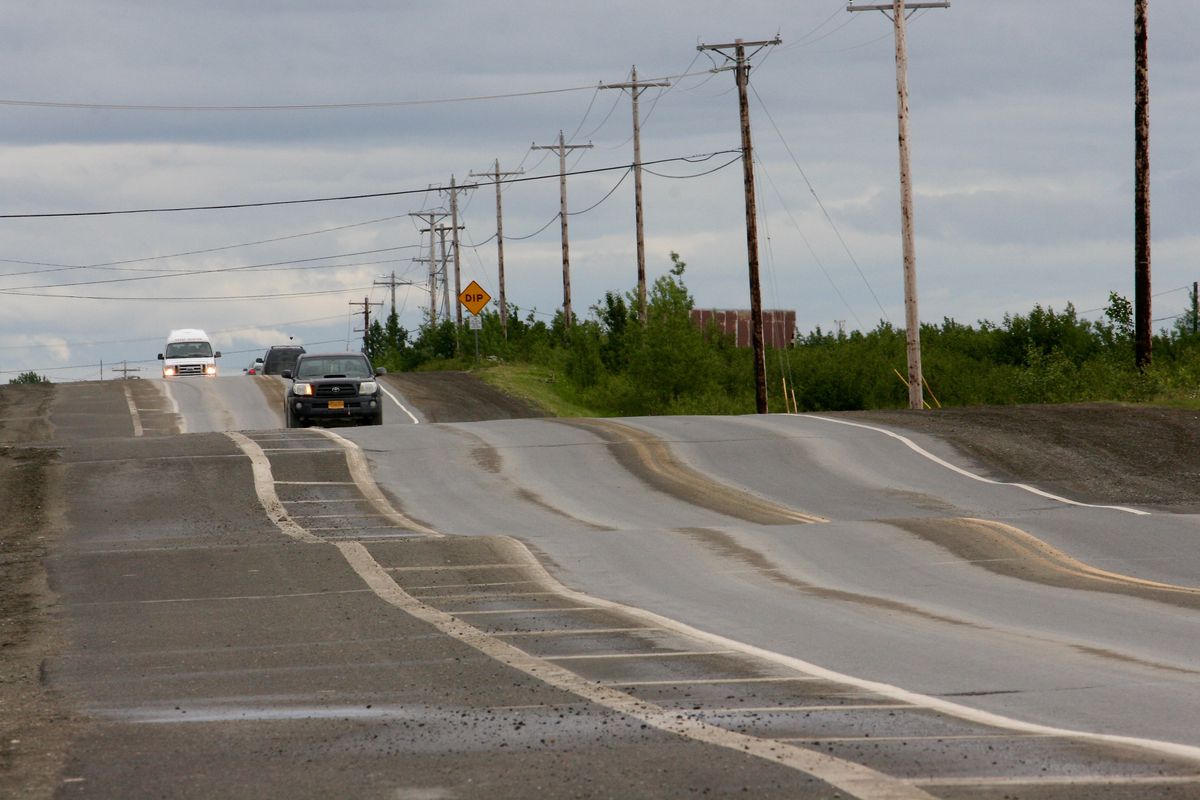
"‘The permafrost is dying’: Bethel sees increased shifting of roads and buildings"
"Along the main thoroughfare here, drivers brake for warped asphalt. Houses sink unevenly into the ground. Walls crack and doors stick. Utility poles tilt, sometimes at alarming angles. Permafrost in and around Bethel is deteriorating and shrinking, even more quickly than most places in Alaska. Since the first buildings out here, people have struggled with the freeze and thaw of the soils above the permafrost. Now those challenges are amplified. "What they are saying is the permafrost is dying," said Eric Whitney, a home inspector and energy auditor in Bethel who has noticed newly eroding river banks, slanting spruce trees and homes shifting anew just weeks after being made level. "I'm just assuming it is not coming back while we're around here.""
(Chief Eddie Hoffman Highway, seen on June 28, is the main thoroughfare in Bethel, and one of few paved roads. It has become a roller coaster of a ride over the past couple of years. The state Department of Transportation is studying whether heaving from the thaw-freeze of permafrost is a factor. (Lisa Demer / Alaska Dispatch News))
_______________________________________________________________
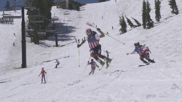
"Rare Calif. summer snowpack fun for skiers--but spawning raging waters downstream"
"Ski lifts ran on Independence Day at Squaw Valley Resort for the fourth time in history. But as the winter's record-breaking snow melts, it's creating raging rivers downstream where dozens of people have already been rescued from the Truckee River. In the High Sierra of California, it's continuing to look a lot like Christmas -- but in July. Two weeks after the official start of summer, skiers at Squaw Valley are refusing to let temperatures near 80 degrees melt away their favorite winter sport, reports CBS News correspondent Carter Evans."
(Skier on July 4 at Squaw Valley Resort in California. Credit: CBS NEWS)
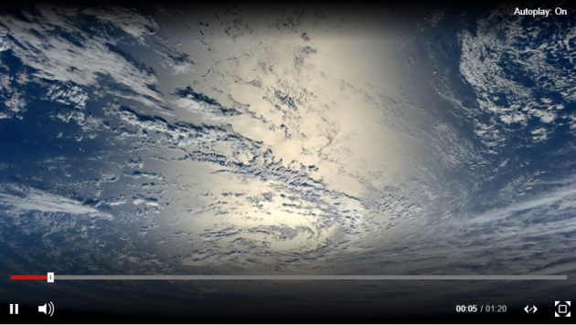
"Aurora time-lapse video dazzles from space"
Being an astronaut on the International Space Station has its perks, including a front row seat to a light show most people will only ever see from the planet's surface. NASA released a time-lapse video on Friday showing a June 25 aurora filmed by a camera on the ISS.

"Florida woman struck by lightning, then gives birth"
A 26-year-old Florida woman was struck by lightning Thursday then gave birth to a baby boy. Meghan Davidson was in a gated community in Fort Myers as a series of heavy storms moved through the area. The lightning strike occurred about 4:30 p.m. First responders found Davidson on the ground when they arrived. She was then taken to a local hospital. South Florida television station NBC 2 reported Davidson was a week away from her due date when the strike occurred, prompting doctors to deliver the baby, Owen. Davidson was in critical condition on Friday. On Monday, she was upgraded to serious condition. The hospital did not provide information on Owen.
(Photo: Lukasz Ogrodowczyk, European Pressphoto Agency)
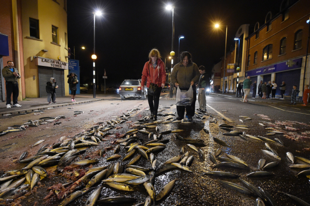
"5 Weird But Real Weather Events"
We don’t remember most of the weather we experience on a daily basis. Even hardcore weather geeks are hard-pressed to recall many events beyond what reporters would cover on the news. But there are some atmospheric tantrums that are memorable because of how bizarre they are. Here are some true-yet-bizarre weather phenomena that you'd be sure to remember if you ever got to experience them firsthand.
(This scene was caused by a tanker full of mackerel spilling on a Belfast street in 2015, but a fish rain might look similar. Image Credit: CHARLES MCQUILLAN/GETTY IMAGES)
"Don’t rely on sunscreen alone this summer"
"Sunscreen is important for protecting your skin from the sun, but it shouldn't be the only thing you use. It’s that glorious time of year when the sun is hot, the days are long, and the outdoors beckons. From balcony to backyard to beach, many of us are happy to soak up the delicious rays that have felt so long in coming. The sunlight may feel wonderful, but it’s not entirely harmless. Too much time in the sun can result in bad sunburns, which are linked to skin cancers – mostly carcinomas, but also much deadlier melanomas. While sunscreens can help reduce the risk of skin cancer, they are not a perfect solution: To be most effective, sunscreens should be paired with other sun-savvy measures. The Environmental Working Group (EWG) urges people to understand how sunscreen works (read: why some brands are much better than others) and to think of it as “just one tool in your arsenal.”"
(Image Credit: Promo image EWG via TreeHugger.com)

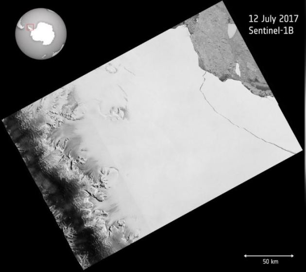
"Giant iceberg breaks off Antarctica"
"One of the biggest icebergs on record has broken away from Antarctica, scientists said on Wednesday, creating an extra hazard for ships around the continent as it breaks up. The one trillion tonne iceberg, measuring 5,800 square km, calved away from the Larsen C Ice Shelf in Antarctica sometime between July 10 and 12, said scientists at the University of Swansea and the British Antarctic Survey. The iceberg has been close to breaking off for a few months. Throughout the Antarctic winter, scientists monitored the progress of the rift in the ice shelf using the European Space Agency satellites. "The iceberg is one of the largest recorded and its future progress is difficult to predict," said Adrian Luckman, professor at Swansea University and lead investigator of Project MIDAS, which has been monitoring the ice shelf for years."
(The one trillion tonne iceberg, measuring 5,800 square km, calved away from the Larsen C Ice Shelf in Antarctica, in an image taken July 12, 2017.)
Thanks for checking in and don't forget to follow me on Twitter @TNelsonWX

No comments:
Post a Comment