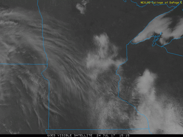
Visible Satellite Loop Monday
The visible satellite loop from Monday showed a fairly sunny day across much of the state. A complex of showers and storms from South Dakota moved into western Minnesota late in the day. This unsettled weather will become more widespread as we head into Tuesday.
Severe Threats: Tuesday & Wednesday
According to NOAA's SPC, there is a risk of strong to severe storms on Tuesday and Wednesday across parts of the region. At this point, there is a better chance for severe storms on Tuesday across much of Minnesota, while the threat on Wednesday shifts a little farther southeast.
.png)
.png)
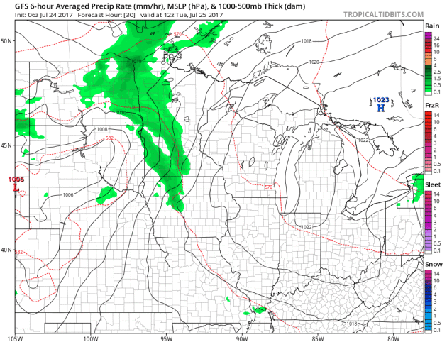
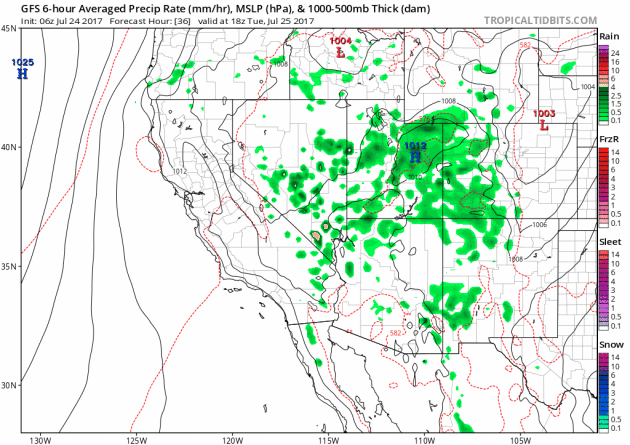
Simulated Radar
The simulated radar from Tuesday to AM Thursday shows our next storm system moving through the Midwest with not only the potential of strong to severe storms, but also the possibility of locally heavy rainfall.
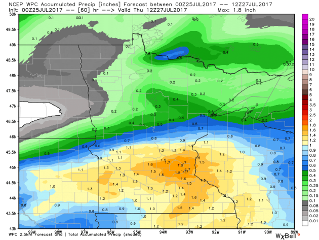
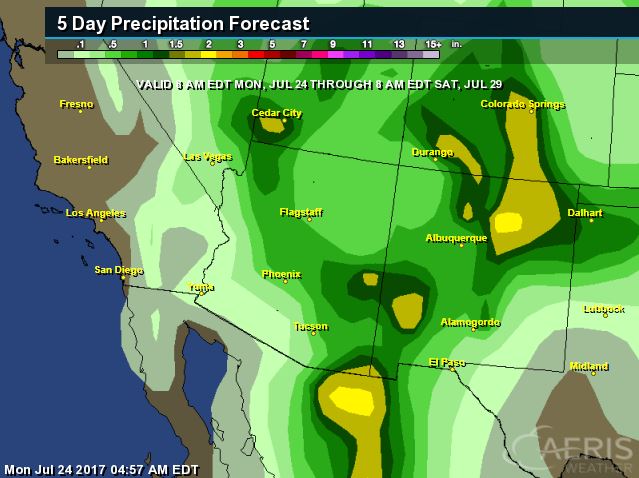
Heavy Rainfall Potential Ahead
The rainfall forecast through AM Thursday shows heavy rainfall potential across the southern half of the state. Note that some locations could see as much as 1" to 2", which could lead to localized areas of flooding.
___________________________________________________________________________
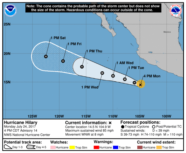
HILARY in the Eastern Pacific
The National Hurricane Center continues to track Hilary, which as of Monday afternoon was a category 1 hurricane with 85mph sustained winds. HILARY became the is the 8th named storm and the 4th hurricane of the 2017 Eastern Pacific Hurricane Season.
.gif)
Here's the official track for HILARY, which has it potentially becoming a major hurricane at some point this week. If it does, it would be the 2nd major hurricane of the season. The other storm was FERNANDA, which developed into a category 4 storm!
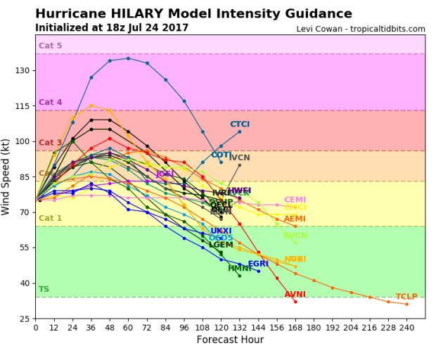
HILARY Strength
Here's the model outlook for HILARY, which shows a trend towards strengthening over the next few days, but only a few bring this to category 3 strength or higher, which is considered to a major hurricane. The majority of the models keep this storm at a category 1 or 2 through the week.
Eastern Pacific Outlook: Next 5 Days
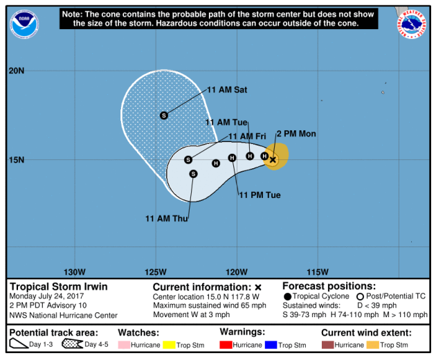
Weather conditions in the Eastern Pacific continue to remain active as NOAA's NHC is keeping an eye on 2 other waves of energy west of HILARY, which are both named. GREG continues well off to the west, but IRWIN has also developed, which is the 9th named storm of the season!
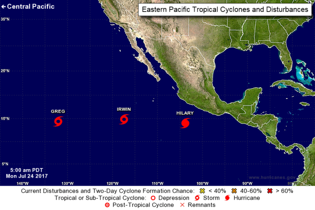
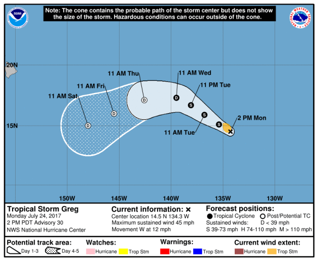
Tracking GREG
According to NOAA's NHC, GREG was still a tropical storm with sustained winds of 45mph. The good news is that this storm is not expected to pose a threat to any major land mass and could be a tropical depression by midweek.
IRWIN became the 9th named storm of the 2017 Eastern Pacific hurricane season and could become the 5th hurricane of the season! The good news with this storm is that it is not expected to impact any major landmass.
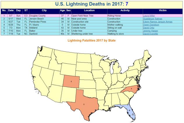
2017 Lightning Fatalities
According to NOAA's NWS, there have been 7 lightning fatalities so far this year, the most recent coming from North Carolina on July 18th as a 40-some year old man was walking to store. Note that 4 of these deaths have occurred in Florida, which is considered to be the lightning capital of the United States.
 Lightning Deaths Over the Last 10 Years
According to NOAA's NWS, lightning kills an average of 47 people each year in United States! Over the last 10 years, 310 people have died from lightning and what is interesting is that nearly 79% have been males!
Lightning Deaths Over the Last 10 Years
According to NOAA's NWS, lightning kills an average of 47 people each year in United States! Over the last 10 years, 310 people have died from lightning and what is interesting is that nearly 79% have been males!
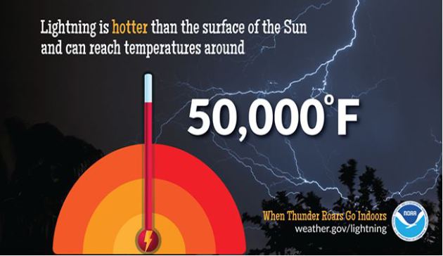
.png) Lightning Safety: Myths & Facts
Did you know that lightning is nearly 5 times hotter than the surface of the sun? Here are a few interesting myths and facts from NOAA's NWS regarding lightning:
Lightning Safety: Myths & Facts
Did you know that lightning is nearly 5 times hotter than the surface of the sun? Here are a few interesting myths and facts from NOAA's NWS regarding lightning:
Myth: If you're caught outside during a thunderstorm, you should crouch down to reduce your risk of being struck.
Fact: Crouching doesn't make you any safer outdoors. Run to a substantial building or hard topped vehicle. If you are too far to run to one of these options, you have no good alternative. You are NOT safe anywhere outdoors. See our safety page for tips that may slightly reduce your risk.
Myth: Lightning never strikes the same place twice.
Fact: Lightning often strikes the same place repeatedly, especially if it's a tall, pointy, isolated object. The Empire State Building is hit an average of 23 times a year
Myth: If it’s not raining or there aren’t clouds overhead, you’re safe from lightning.
Fact: Lightning often strikes more than three miles from the center of the thunderstorm, far outside the rain or thunderstorm cloud. “Bolts from the blue” can strike 10-15 miles from the thunderstorm.
Myth: Rubber tires on a car protect you from lightning by insulating you from the ground.
Fact: Most cars are safe from lightning, but it is the metal roof and metal sides that protect you, NOT the rubber tires. Remember, convertibles, motorcycles, bicycles, open-shelled outdoor recreational vehicles and cars with fiberglass shells offer no protection from lightning. When lightning strikes a vehicle, it goes through the metal frame into the ground. Don't lean on doors during a thunderstorm.
Myth: A lightning victim is electrified. If you touch them, you’ll be electrocuted.
Fact: The human body does not store electricity. It is perfectly safe to touch a lightning victim to give them first aid. This is the most chilling of lightning Myths. Imagine if someone died because people were afraid to give CPR!
Myth: If outside in a thunderstorm, you should seek shelter under a tree to stay dry.
Fact: Being underneath a tree is the second leading cause of lightning casualties. Better to get wet than fried!
See more on lightning including safety tips HERE:
 ___________________________________________________________________________
National Weather Hazards Ahead...
According to NOAA's NWS, there have been 7 lightning fatalities so far this year, the most recent coming from North Carolina on July 18th as a 40-some year old man was walking to store. Note that 4 of these deaths have occurred in Florida, which is considered to be the lightning capital of the United States.
Myth: If you're caught outside during a thunderstorm, you should crouch down to reduce your risk of being struck.
Fact: Crouching doesn't make you any safer outdoors. Run to a substantial building or hard topped vehicle. If you are too far to run to one of these options, you have no good alternative. You are NOT safe anywhere outdoors. See our safety page for tips that may slightly reduce your risk.
Myth: Lightning never strikes the same place twice.
Fact: Lightning often strikes the same place repeatedly, especially if it's a tall, pointy, isolated object. The Empire State Building is hit an average of 23 times a year
Myth: If it’s not raining or there aren’t clouds overhead, you’re safe from lightning.
Fact: Lightning often strikes more than three miles from the center of the thunderstorm, far outside the rain or thunderstorm cloud. “Bolts from the blue” can strike 10-15 miles from the thunderstorm.
Myth: Rubber tires on a car protect you from lightning by insulating you from the ground.
Fact: Most cars are safe from lightning, but it is the metal roof and metal sides that protect you, NOT the rubber tires. Remember, convertibles, motorcycles, bicycles, open-shelled outdoor recreational vehicles and cars with fiberglass shells offer no protection from lightning. When lightning strikes a vehicle, it goes through the metal frame into the ground. Don't lean on doors during a thunderstorm.
Myth: A lightning victim is electrified. If you touch them, you’ll be electrocuted.
Fact: The human body does not store electricity. It is perfectly safe to touch a lightning victim to give them first aid. This is the most chilling of lightning Myths. Imagine if someone died because people were afraid to give CPR!
Myth: If outside in a thunderstorm, you should seek shelter under a tree to stay dry.
Fact: Being underneath a tree is the second leading cause of lightning casualties. Better to get wet than fried!
See more on lightning including safety tips HERE:
PRELIMINARY 2017 Tornado Map
It certainly has been a fairly active first half of 2017 with 1190 preliminary tornado reports through July 23rd. Note that this is the most tornadoes through July 23rd since 2011, when there were 1,662 reports. The map below shows the distribution of the tornadoes so far this year.
.gif) PRELIMINARY 2017 Tornado Count
PRELIMINARY 2017 Tornado Count
According to NOAA's SPC, the PRELIMINARY 2017 tornado count is 1190 (through July 23). Note that is the most active year for tornadoes since 2011, when there were 1,662 tornadoes. Keep in mind there was a major tornado outbreak in the Gulf Coast region from April 25-28, 2011 that spawned nearly 500 tornadoes, some of which were deadly. That outbreak is known as the Super Outbreak of 2011 and has gone down in history as one of the biggest, costliest and one of the deadliest tornado outbreaks in history.
.png)
____________________________________________________________
According to NOAA's SPC, the PRELIMINARY 2017 tornado count is 1190 (through July 23). Note that is the most active year for tornadoes since 2011, when there were 1,662 tornadoes. Keep in mind there was a major tornado outbreak in the Gulf Coast region from April 25-28, 2011 that spawned nearly 500 tornadoes, some of which were deadly. That outbreak is known as the Super Outbreak of 2011 and has gone down in history as one of the biggest, costliest and one of the deadliest tornado outbreaks in history.
____________________________________________________________
2.) Heavy rain across portions of the Southwest, Central and Southern Rockies, and the Central and Southern Plains, Thu-Fri, Jul 27-Jul 28.
3.) Heavy rain across portions of the Northeast, Thu-Fri, Jul 27-Jul 28.
4.) Heavy rain across portions of the Southeast and the Mid-Atlantic, Sat-Sun, Jul 29-Jul 30.
5.) Flooding occurring or imminent across portions of the Upper and Middle Mississippi Valley and the Great Lakes.
6.) Flooding possible across portions of the Central and Southern Plains, the Central and Southern Rockies, the Central Great Basin, and the Southwest.
7.) Flooding likely across portions of the Middle Mississippi Valley.
8.) Slight risk of much above-normal temperatures for portions of the Great Basin, the Northern Plains, the Northern Rockies, California, the Pacific Northwest, and the Southwest, Tue-Sat, Aug 1-Aug 5.
9.) Severe Drought across parts of the Great Plains, Arizona, California, and Hawaii.
.png)
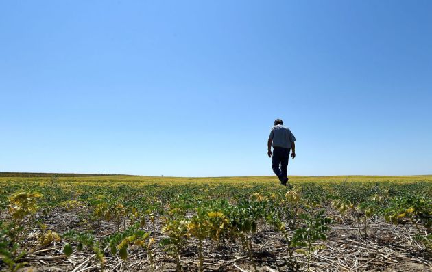
"The life had been fading from Grant Zerbe's stunted chickpeas for the better part of a month, and now drought’s hot breath was burning through the final green inch of every plant stem.The Montana farmer’s worst growing season in 30 years was coming to a brutal end. There are few crops to harvest in the region, and with a lack of food and water, unwanted livestock are headed to auction. “Normally, we’d be getting 1,200 pounds to an acre,” Zerbe said. “The crop would be so thick you couldn’t see the ground.” Northeast Montana is experiencing the worst drought in the country. On U.S. Drought Monitor maps, the Montana portion branded "extreme" spans 350 miles. Combined with drought in the Dakotas, Montana’s losses contribute to what the U.S. Department of Agriculture expects to be a 64 million bushel loss in wheat production. Durum, a specialty crop for Montana and North Dakota, is expected to be down in bushels 45 percent from last year."
See more from BillingsGazette HERE:
(Frazer area farmer Grant Zerbe checks a chickpea crop as a drought grips eastern Montana. LARRY MAYER, Gazette Staff)
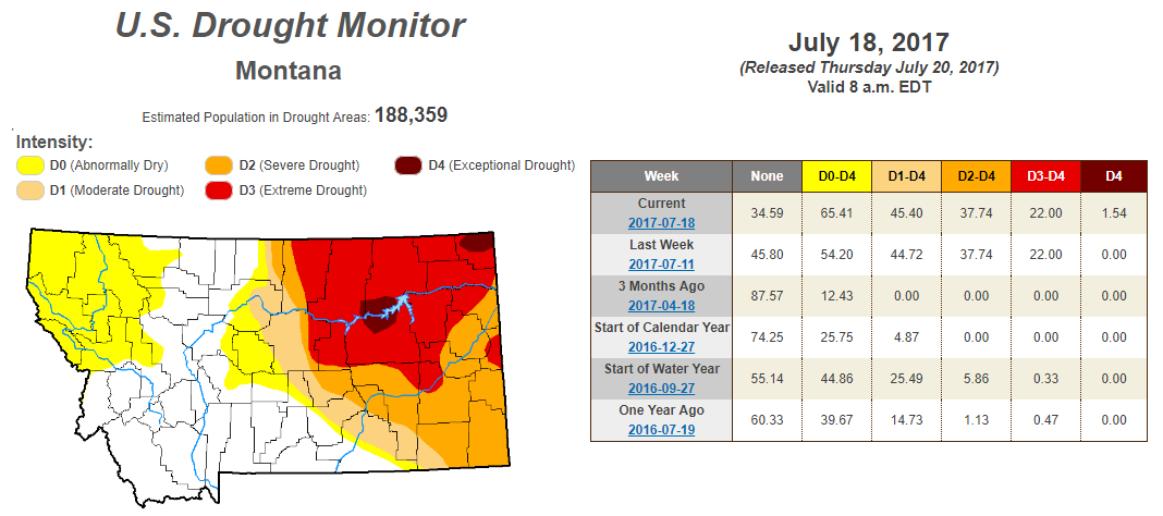
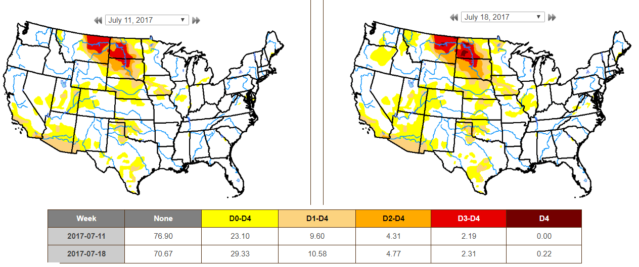
According to the US Drought Monitor, parts of Montana are now under an EXCEPTIONAL Drought. While nearly 2% is considered to be in an EXCEPTIONAL drought, 22% is under an EXTREME drought. Also, nearly 65% of the state is considered to be either abnormally dry or in some type of drought.
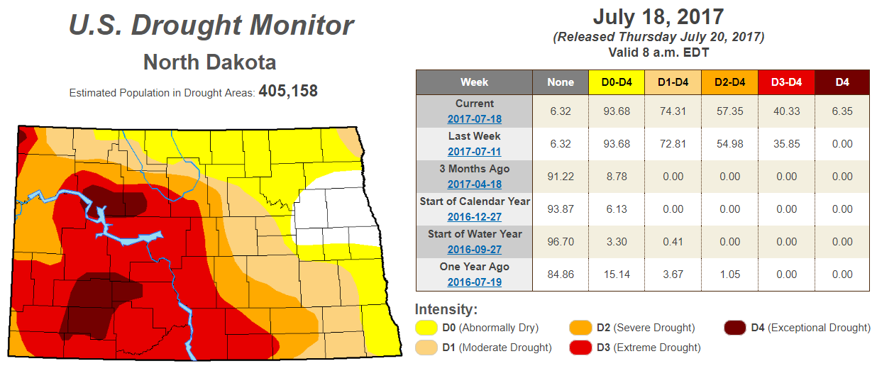
EXCEPTIONAL Drought in North Dakota
According to the US Drought Monitor, parts of North Dakota are now under an EXCEPTIONAL Drought. Interestingly, this is the first time since 2006! While a little more than 6% is considered to be in an EXCEPTIONAL drought, more than 40% is under an EXTREME drought, which is up from the nearly 36% last week. Also, nearly 94% of the state is considered to be either abnormally dry or in some type of drought.
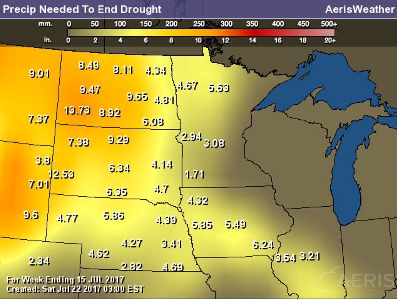
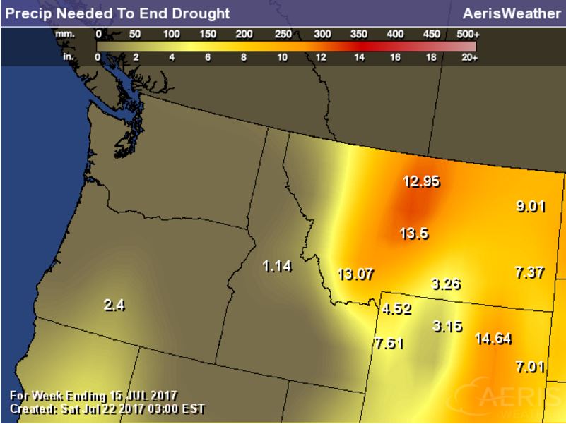
Rain Needed to End Drought
Exceptional and Extreme drought conditions are in place over parts of Montana and North and South Dakota due to several days/week of hot and dry weather. The image below suggests how much rain would be needed to end the drought, which suggests nearly 6" to 12" or more!
US Drought Monitor
According to the US Drought Monitor, drought conditions from July 11h to July 18th worsened slightly across the nation. Note that EXCEPTIONAL and EXTREME drought conditions (located across parts of Montana and parts of North and South Dakota increased from last week
_________________________________________________________________________
National Weather Outlook
Here's the weather outlook through the early weekend suggests that stormy weather returns to the Midwest with strong to severe storms and locally heavy rainfall midweek. Monsoon storms continue in the Southwest with a few strong storms and areas of locally heavy rain. Late week and early weekend, another round of storms and heavy rain will move in along the Eastern US.
.gif)
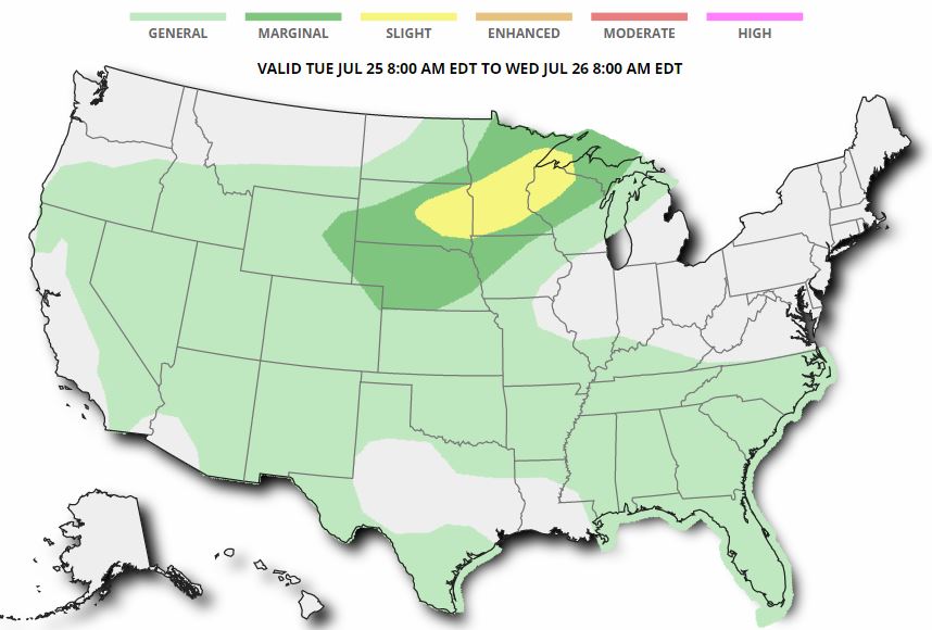
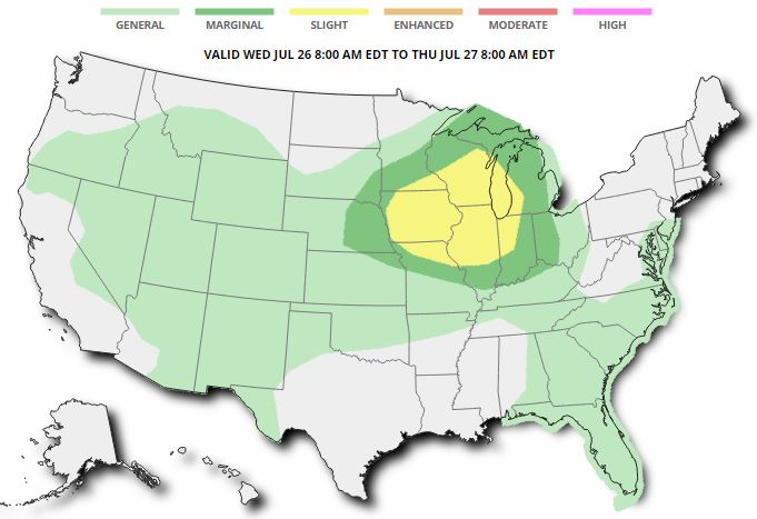
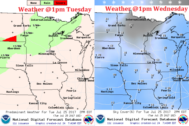
Severe Threats Tuesday & Wednesday
According to NOAA's SPC, there is a SLIGHT risk of severe storms across parts of the Midwest on Tuesday, while another SLIGHT risk of severe storms has been posted across parts of the Midwest/Great Lakes/Ohio Valley on Wednesday. In these areas, large hail, damaging winds and locally heavy rains will be possible in these areas.
Excessive Rainfall Potential Tuesday & Wednesday
According to NOAA's WPC, there is a risk of excessive rain on on Tuesday across parts of the Western US and Midwest. Some of the same areas could see heavy rain and flooding once again on Wednesday.
.gif)
.gif)
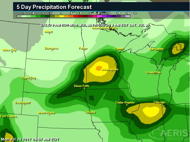
Localized Heavy Rain Threats
Excessive rainfall potential is in place over parts of the Midwest over the next couple days and the rainfall forecast suggests some 1" to 2"+ rainfall tallies through AM Saturday. Areas of heavy rain could lead to localized areas of flooding.
________________________________________________________
Monsoonal Storms
WOW - take a look at this video that @WesCallisonTNN tweeted a couple of days ago, which shows a monsoon storm developing and dumping a huge blob of heavy rain over some of the mountains in Arizona. These types of heavy rainfall events can lead to dust storms and flash flooding.

Here's the simulated radar from Tuesday to Saturday, which shows the potential of daily monsoon storms continuing across the region. Note that some of the storms could be a little on the strong side with gusty winds, dust storms and locally heavy rain, which could lead to localized flooding. The 5 day rainfall forecast below suggests that some areas could see up to 1" of rain or more through the end of next week!
 ________________________________________________________________________
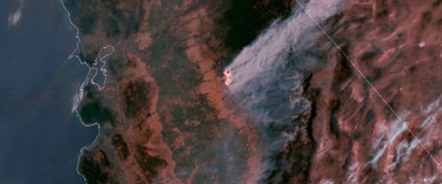
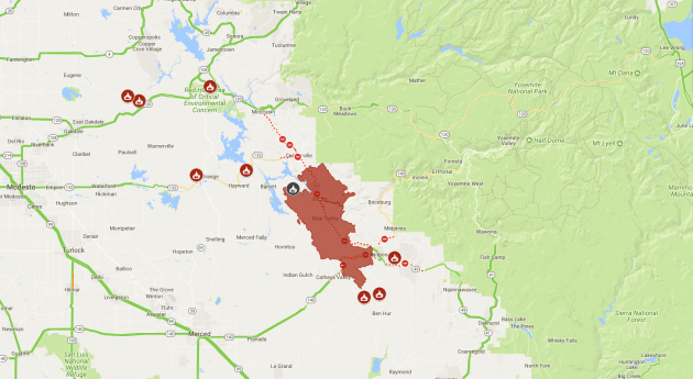
"Crews stop spread of huge California wildfire near Yosemite"
"Crews contending with triple-digit temperatures slowed the spread of an aggressive wildfire that destroyed dozens of homes in a rural area of California near Yosemite National Park, officials said Sunday. The blaze burning for a week has scorched just over 119 square miles (308 square kilometers) of dense brush and dead trees in the Sierra Nevada foothills. Many evacuated residents were allowed to return, but flames continue to threaten about 1,500 homes in Mariposa County. The fire was 45 percent contained, but officials said it could take crews another two weeks to fully surround it. "They are still out in front of an uncontrolled fire, but the fire isn't moving at 30 mph (48 kph). The fire is crawling along," fire spokesman Brandon Vaccaro said Saturday. Flames spared Mariposa, a historic Gold Rush-era town, but more than 130 buildings, including 63 homes, were destroyed. More than 5,000 firefighters fought the blaze using air tankers and fleets of helicopters and bulldozers."
(This satellite imagery, posted Wednesday, July 19, 2017 on a National Oceanic and Atmospheric Administration website, shows a large plume of smoke spreading hundreds of miles east from the Ditwiler fire, near Yosemite National Park in California's Sierra Nevada. Authorities say the stubborn wildfire burning in foothills west of Yosemite had destroyed dozens of structures while forcing thousands of people from their homes Wednesday. The San Francisco Bay Area is at left; Lake Tahoe is at top center. (National Oceanic and Atmospheric Administration)
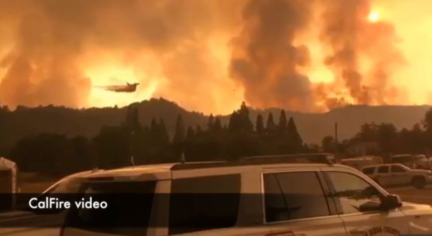
DetWiler Fire - Near Yosemite - California
The Detwiler Fire located near Yosemite National Park in California has ballooned to a very large 76,500 acre fire since Sunday, July 16th. This fire has already consumed more than 130 structures; 63 homes, 67 minor structures and 1 commercial structure. A number of other homes and smaller structures have been damaged as well, but 1,500 other structures are being threatened now. There are almost 4,200 people working on the fire and it is only 50% contained at this point . Higher humidity levels are helping create better fire fighting conditions.
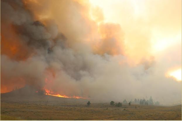
Lodgepole Complex - Montana
According to Inciweb, one of the largest fires currently burning in the Lower 48 is the Lodgepole Complex located 52 miles NW of Jordan, MT. This particular fire has consumed a whopping 226,000 acres and is expected to be fully contained by Wednesday, August 2nd. This particular fire started on Wednesday, July 19th and quickly spread as hot, dry and windy weather created extreme fire behavior. Gusty winds are still posing a concern for the fire.
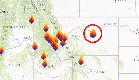
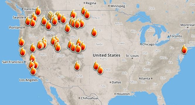
Ongoing Large Wildfires
Here's a look at the current wildfire map across the country. Recent hot and dry weather has helped to spark several wildfires across the Western US, while a few have also been popping up in the Eastern US.
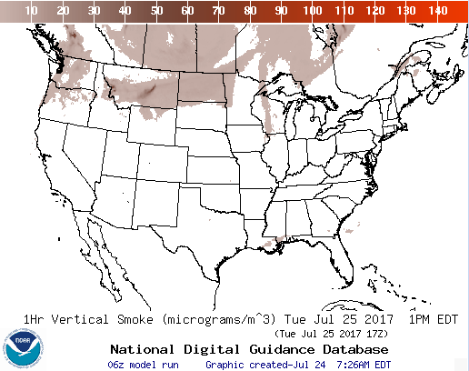
National Smoke Analysis
Here's the projected wildfire smoke concentration for midday Tuesday, which suggests that smoke from wildfires burning across parts of Canada and the Western US could continue to linger around the Upper Midwest/Great Lakes region. There also appears a very high concentration of smoke from fires burning across the western half of Canada. If you are in these areas, air quality could be a little poor, but these areas may also be enjoying very interesting looking sunrises/sunsets, which tend to look hazy or reddish-orange.
________________________________________________________________________
Remembering 1987. Sticky sun & storms later Tuesday
By Todd Nelson, filling in for DouglasIt's been 30 years since the 1987 Homer Hanky was being waved. Big bats from Dan Gladden in game 1 and Kent Hrbek in game 6 along with a loaded pitching staff that included Bert Blylevin and MVP Frankie "Sweet Music" Viola helped bring home the 1st World Series for the MN Twins that year. My ears are still ringing from the roar in Dome. WOW - What a year!
It has also been 30 years since the 1987 Twin Cities Superstorm when 10 inches of rain fell at the Twin Cities Airport from July 23rd to 24th. This caused massive flooding across parts of the metro, which lead to nearly $30 million in damages and 2 flood related deaths.
1987, no question, was an interesting summer.
Sticky sunshine returns Tuesday with dewpoints spiking in the upper 60s and low 70s. This could help spark a few strong to severe storms later with rounds of heavy rain overnight. Some in southern Minnesota could see as much as 1 to 3 inches of rain through early Wednesday, but Chamber of Commerce days look to return Thursday through Saturday. Soak it up!
________________________________________________________________________
Extended Forecast
TUESDAY: Sticky. Strong storms late. Winds: S 8-13. High: 87.
TUESDAY NIGHT: Scattered showers and storms with locally heavy rain. Low: 71
WEDNESDAY: Lingering storms early. PM clearing. Winds: NNW 5-10. High: 84
THURSDAY: Nice day. Sun returns, less humid. Winds: NNE 5. Wake-up: 65. High: 82
FRIDAY: Another beauty. Sneak out early. Shh! Winds: ESE 5. Wake-up: 63. High: 83
SATURDAY: Keep it coming. Winds: SW 5-10. Wake-up: 64. High: 84.
SUNDAY: Warmer, more humid. A few rumbles. Winds: W 5. Wake-up: 66. High: 86
MONDAY: Passing clouds. Looks dry. Winds: S 5-10. Wake-up: 70. High: 82.
_______________________________________________________
_______________________________________________________
This Day in Weather History
July 25th
July 25th
2000: An F4 tornado hits the town of Granite Falls. One person is killed and there is 20 million dollars in damage.
1915: Frost hits northeastern Minnesota.
________________________________________________________
________________________________________________________
Average High/Low for Minneapolis
July 25th
July 25th
Average High: 83F (Record: 99F set in 1999)
Average Low: 64F (Record: 50F set in 1891)
Average Low: 64F (Record: 50F set in 1891)
Record Rainfall: 2.07" set in 1878
_________________________________________________________
_________________________________________________________
Sunrise/Sunset Times for Minneapolis
July 25th
July 25th
Sunrise: 5:51am
Sunset: 8:47pm
Sunset: 8:47pm
Hours of Daylight: 14hours & 56mins
Daylight LOST since yesterday: ~2 minutes and 7 seconds
Daylight LOST since summer solstice (June 20th): ~41 minutes
__________________________________________________________
Daylight LOST since summer solstice (June 20th): ~41 minutes
__________________________________________________________
Moon Phase for July 25th at Midnight
2.9 Days Since New Moon
2.9 Days Since New Moon
.gif)
_________________________
Weather Outlook For Tuesday
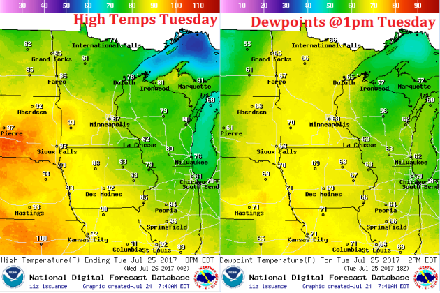
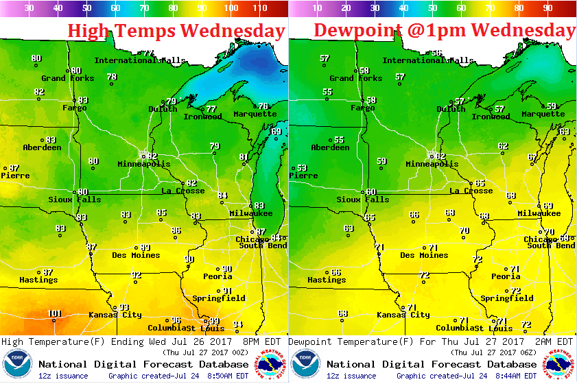
After a couple of cooler, more comfortable days across the state Sunday & Monday, the heat and humidity will return on Tuesday with highs approaching 90F across the southern and western part of the state. Dewpoints will also warm into the 60s & low 70s across much of the state, which will make it feel quite sticky once again.
Weather Outlook For Tuesday
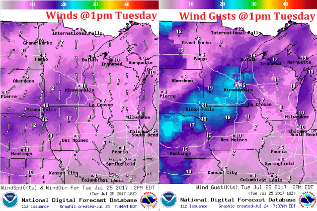
A southerly wind will develop and strengthen a bit ahead of our next storm system that will move through Tuesday. Winds will be sustained around 10-15mph with gusts approaching 20mph across the southern half of the state. This wind will also help to transport the higher dewpoints back into the region.
Weather Outlook For Tuesday
Here's the weather depiction for midday Tuesday, which shows an increase in precipitation potential across the central and northern part of the state. Note that the best potential for thunderstorm activity won't arrive until late afternoon/evening.
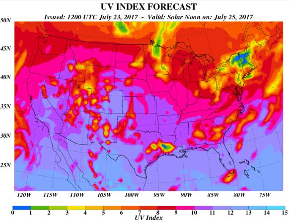
Despite there being more clouds across the region, the UV Index will still be considered HIGH on Tuesday, which means that it will only 20 to 30 minutes or less to burn unprotected skin. With that said, if you are planning on spending any extended length of time outside, make sure you wear appropriate attire and lather on the sun block!
 __________________________________________________________________________
Weather Outlook For Wednesday
A cold front will continue to push south of the region on Wednesday with scattered showers and storms drifting southeast along with it Cool and somewhat less humid air will begin settle south behind the front, which will be a little more evident later Wednesday and certainly into Thursday.
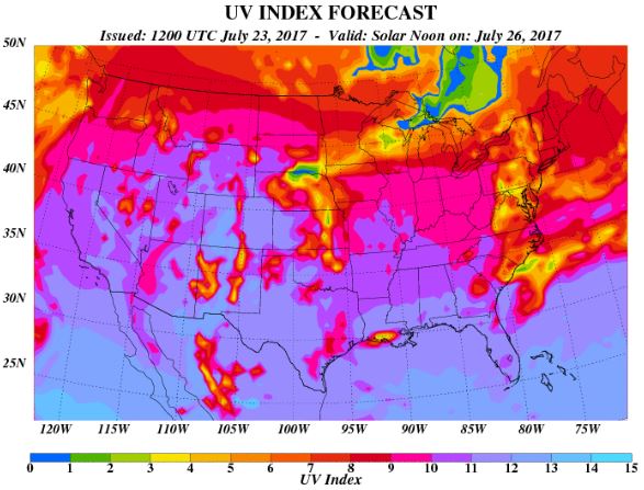
UV Index for Wednesday - VERY HIGH
As scattered showers and storms sag south through the region during the day, areas of sun will begin to pop out later. With that said, the UV Index for Wednesday is expected to be HIGH once again, which means that your skin could burn in 15 to 20 minutes or less!
 _____________________________________________________________
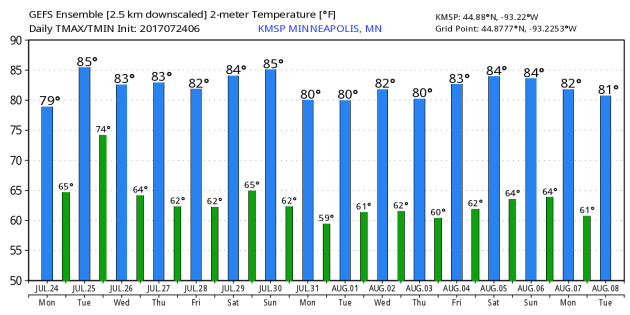
Minneapolis Temperature Outlook
Here's the temperature outlook through August 8th, which shows temperatures hovering in the 80s through the rest of the month and into the early part of August. Keep in mind that the average high in the Twin Cities through August 8th is 82F, so we should be pretty close to average.
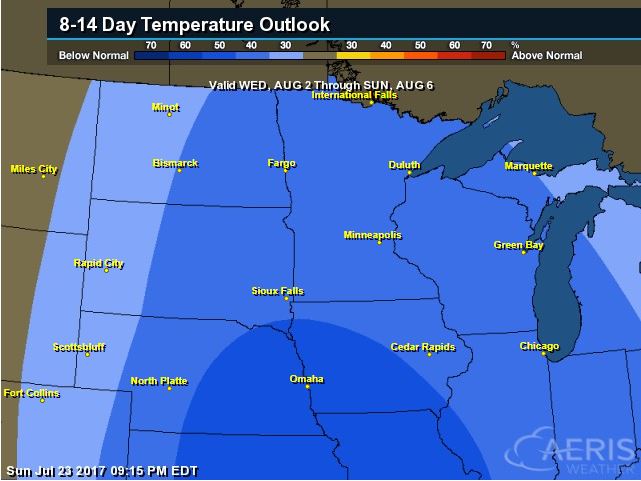
8 to 14 Day Temperature Outlook
According to NOAA's CPC, the extended temperature outlook from August 2nd to August 5th suggests cooler than average temperatures moving into much the Upper Midwest as we head into the early part of August.
___________________________________________________________
Extended Temperature Outlook
According to NOAA's CPC, the extended temperature outlook through August 6th shows that a large chunk of the Central US will be dealing with cooler than normal temperatures, while the western part of the country will still be above average.

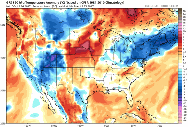
Extended Temperature Outlook
Here's the extended 850mb temperature anomaly loop into early next. This describes how warm or cold (from average) mid/low level temperatures will be over time. Note that the warmer oranges and reds will begin to settle in along the northern tier of the nation through the end of the month/early August, but there some cooler than average temps settling in across the Central US as well.
Weather Outlook Ahead
The weather outlook over the next couple of days shows stormy weather continuing across parts of the Eastern US and the Desert Southwest, but another round of strong to severe storms with locally heavy rainfall will also move in across the Upper Midwest through midweek.
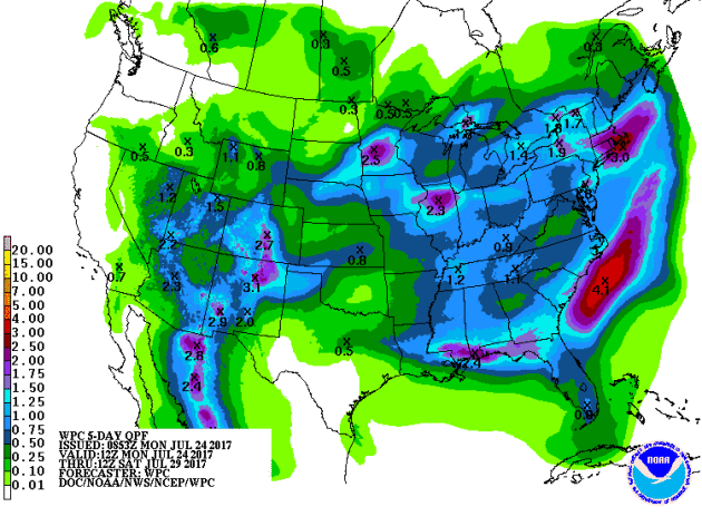
5 Day Precipitation Outlook
According to NOAA's WPC, the next several days could produce areas of locally heavy rainfall across many areas from the Desert Southwest to the Midwest and eastern half of the country. Some of the heaviest rainfall could add up to as much as 1" to 3"+, which could also lead to areas of localized flooding.
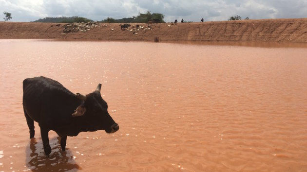
"As The Climate Changes, Kenyan Herders Find Centuries-Old Way Of Life In Danger"
"Out here, in West Pokot County, Kenya, the landscape looks like Mars — red clay, rocks, and in the distance, a mountain so bare it looks like a giant boulder. Stephen Long'uriareng, 80, has walked two hours to bring her two cows and goats to this watering hole. It's really just a dam carved out the earth, where the rain water mixes with mud and turns into a dark brown color. This is not the place Long'uriareng remembers from her youth. "This whole place used to be green with a lot of pasture. There was nothing being experienced like drought," she said."
(As the drought has extended into yet another rainy season, some herders walk for hours to get to this dam. Eyder Peralta/NPR)
 _____________________________________________________________________________
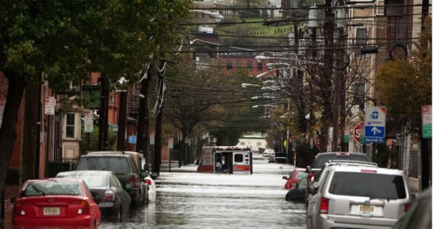
"This mayor is leaving politics to fight climate change full-time"
"Like many communities skirting the U.S. coastline, Hoboken, New Jersey, wasn’t built on solid ground. Many of its charming brick buildings, historic piers, and apartment towers stand atop what was once a low-lying tidal marsh — a grassy, muddy buffer along the Hudson River, designed by nature to absorb high tides and storm surge like a sponge. Early developers drained the marshlands in the 1800s to make way for modern Hoboken: the birthplace of singer Frank Sinatra, the location of TLC’s Cake Boss, and home to 53,000 people packed within the 1.25-square-mile city limit. Across the river, Manhattan’s glassy skyscrapers sparkle in the summer sunlight."
(Hoboken's streets are flooded in the aftermath of Hurricane Sandy on Oct. 30, 2012. IMAGE: MICHAEL BOCCHIERI/GETTY IMAGES)
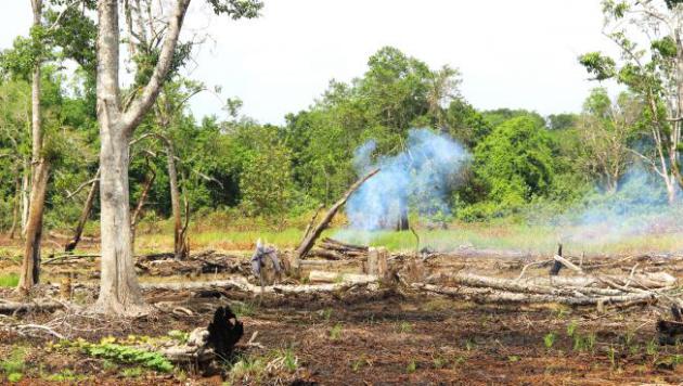
"A super-simple strategy may be key to fighting climate change"
"A key strategy in the fight against climate change is slowing the rapid destruction of the world’s forests. When trees burn or decompose, they release carbon. About 10 percent of the greenhouse gases emitted every year are from this newly freed carbon rising into the atmosphere. In recent years, developed countries have committed billions of dollars to help developing countries prevent deforestation. Some of the funds have been used to pay landowners not to cut down their trees. Part of the goal is to give landowners income that isn't dependent on clearing land for agriculture or selling timber to meet big expenses."
(A small patch of forest still burns after being cleared for farming in West Kalimantan, Indonesia. Credit: Titis Setianingtyas/PRI)
"How does climate change impact you?"
"Most people in Idaho believe climate change will not impact them. They think polar bears may be in trouble, or that people that live along the coast may have problems, but they don’t think it will cause problems in Idaho anytime soon. In reality, climate change is already impacting most of us in one way or another. Anyone who buys insurance is seeing the cost increase. More storms, more fires, more floods; about 5 times more severe weather events than we had 50 years ago. This means higher insurance premiums. Federal agencies are having to cut back on road maintenance, campground maintenance and nearly everything else because they are spending nearly half of their budget fighting fires. City, county, and state governments are having to increase taxes and/or reduce services with the added costs from severe storms."

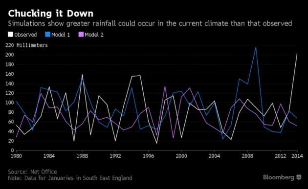
"U.K. Braced for Record-Breaking Wet Winters Blames Climate Shift"
"Britain faces a future of record-breaking wet winters, potentially leading to more of the widespread flooding seen in recent years, according to new modeling that incorporates changing climate patterns. England and Wales now have a 34 percent chance of record rainfall between October and March, the study by the government’s Met Office said on Monday. In 2013, heavy rain deluged parts of Cornwall and the south east. That was followed by three named storms that flooded some of Cumbria, Lancashire and Yorkshire in December 2015, while Storm Angus battered parts of Britain last November."
"North Korea is experiencing its worst drought since 2001, prompting officials to fear an increase in food shortage in the communist country that has suffered serious famine for years, a report by a United Nations agency revealed. The U.N. Food and Agriculture Organization released the report on Thursday that detailed a prolonged dry period in North Korea from April to June, an important time for crop development. It's production of staple crops such as rice, corn, potatoes and soybeans has been damaged, "threatening food security for a large part of its population," the agency said."
See more from FoxNews HERE:
(Image Courtesy: FoxNews)

__________________________________________________________________
Thanks for checking in and don't forget to follow me on Twitter @TNelsonWX

No comments:
Post a Comment