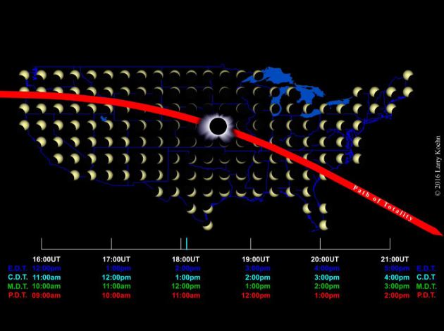
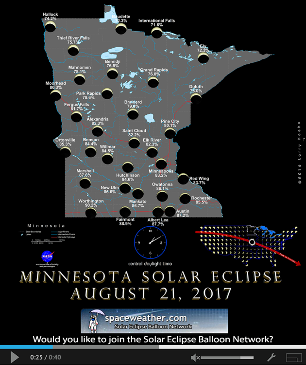
August 21st Solar Eclipse
"The Great American Solar Eclipse is less than one month away. How much of the sun will be covered over your home town? A great way to find out: Animated eclipse maps created by science-artist Larry Koehn. On his web site, there are individual maps for all 50 US states as well as little-known eclipse zones in Canada and Europe. Check it out!"
Tornado Warned Storm PM Tuesday
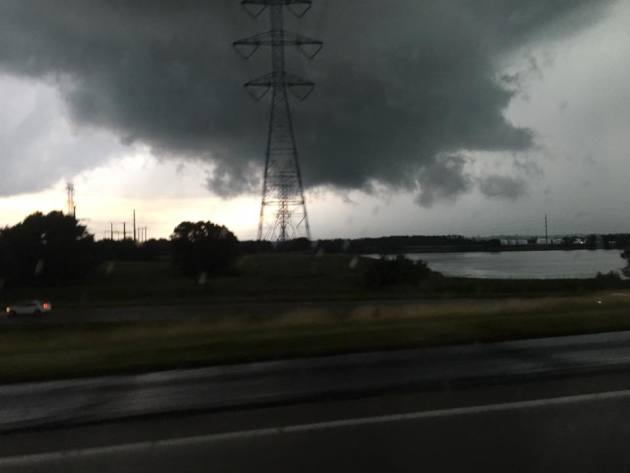
Thanks to Julie Kruse for the picture below who snapped this near Eden Prairie Tuesday evening as a tornado warned storm drifted southeast across the southern Metro. While no tornado was reported, the cell did show signs of rotation and the low cloud looked quite ominous. Thank goodness this storm didn't produce a tornado as it would've impacted highly populated areas!
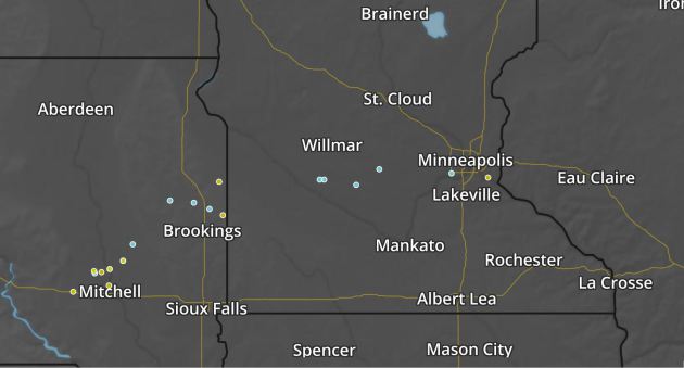
Storm Reports From Tuesday
Storms quickly developed across the region Tuesday afternoon and evening and they were responsible for a few hail and wind damage reports. The image below shows where those storm reports were located with golf ball (1.75") hail being reported in Eden Prairie.
Here's the radar loop from late Tuesday evening into early Wednesday morning as scattered showers and storms rumbled through the region. Some of the storms produced severe weather reports and locally heavy rains.
.gif)
___________________________________________________________________
Simulated Radar Ahead...
The simulated radar from AM Thursday to PM Monday shows unsettled mostly quiet weather returning to the Upper Midwest/Great Lake/Ohio Valley as we head into the end of the week/weekend ahead. A bubble of high pressure will be responsible for the sublime weather, which will help to keep mostly sunny skies in place along with comfortable temperatures. Note that as we head into the late weekend/early next week time frame showers and thunderstorms could return to the area.
.gif)
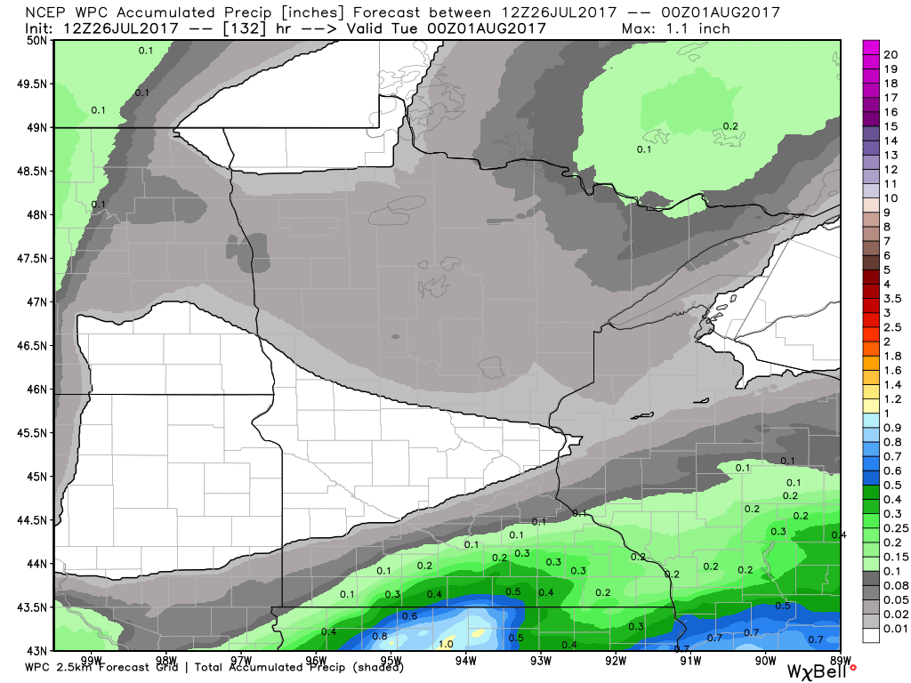
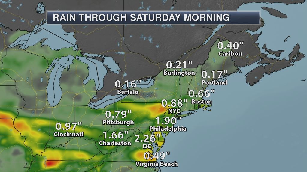
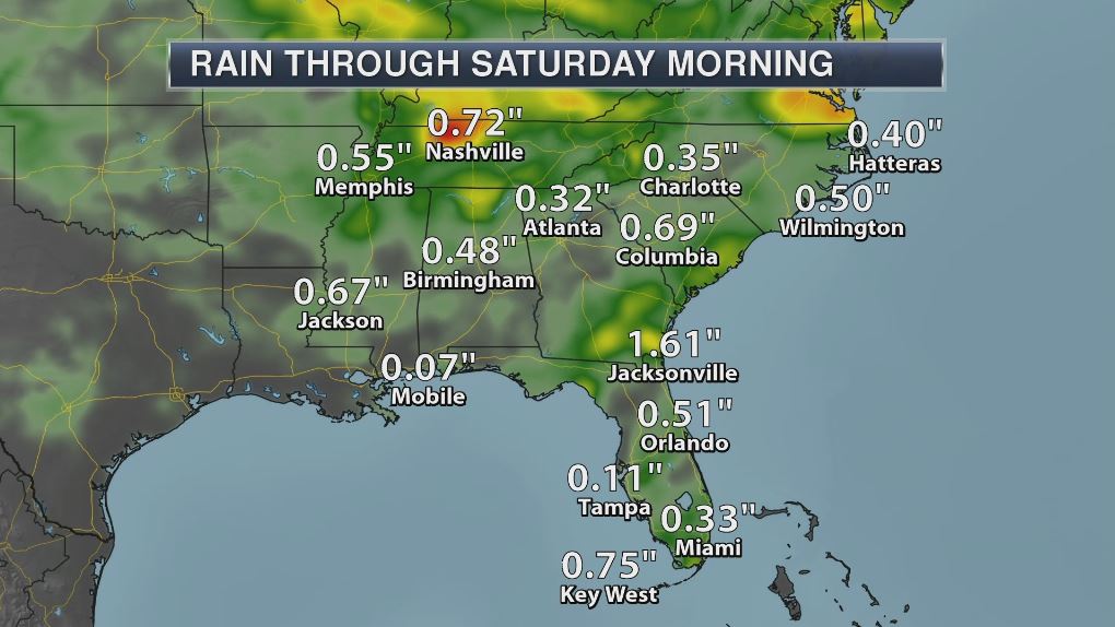
Rainfall Potential Ahead
The rainfall forecast through PM Monday shows the heaviest rains from PM Tuesday/AM Wednesday moving southeast of the region. The extended forecast from Thursday - Saturday looks mostly dry with only a little rain potential moving in Sunday & Monday. Stay tuned...
___________________________________________________________________________
HILARY in the Eastern Pacific
The National Hurricane Center continues to track Hilary, which as of early Wednesday was a category 2 hurricane with 105mph sustained winds. HILARY became the is the 8th named storm and the 4th hurricane of the 2017 Eastern Pacific Hurricane Season.
.gif)
Here's the official track for HILARY, which has it potentially becoming a major hurricane at some point this week. If it does, it would be the 2nd major hurricane of the season. The other storm was FERNANDA, which developed into a category 4 storm!
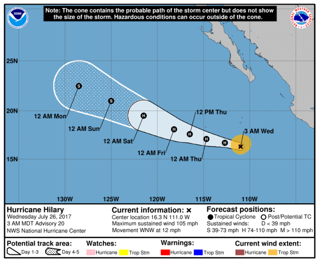
Here's the model outlook for HILARY, which shows a trend towards strengthening over the next few days, but only a few bring this to category 3 strength, which is considered to a major hurricane. The majority of the models keep this storm at a category 1 or 2 through the week.
.png)
Eastern Pacific Outlook: Next 5 Days
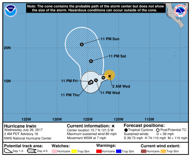
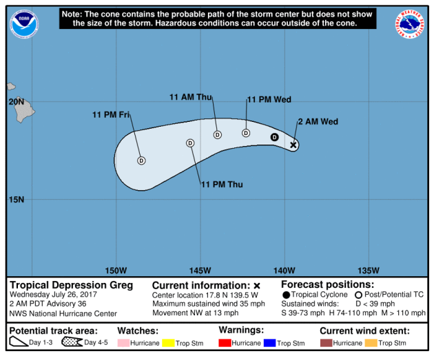
Weather conditions in the Eastern Pacific continue to remain active as NOAA's NHC is keeping an eye on 3 other waves of energy, 2 of which are named. GREG has become a tropical depression well off to the west, but IRWIN continues a hurricane, which is the 9th named storm of the season and the 5th hurricane of the season. There is also another wave of energy that has a low probability of tropical development in the next 5 days.
.png)
Tracking IRWIN
According to NOAA's NHC, as of early Wednesday, IRWIN was a category 1 hurricane with 80mph sustained winds.
.gif)
Tracking IRWIN
IRWIN became the 9th named storm of the 2017 Eastern Pacific hurricane season and has become the 5th hurricane of the season! The good news with this storm is that it is not expected to impact any major landmass.
According to NOAA's NHC, GREG has been downgraded to a tropical depression with sustained winds of 35mph. The good news is that this storm is not expected to pose a threat to any major land mass and should continue to diminish through the end of the week.
PRELIMINARY 2017 Tornado Map
It certainly has been a fairly active first half of 2017 with 1192 preliminary tornado reports through July 25th. Note that this is the most tornadoes through July 25th since 2011, when there were 1,664 reports. The map below shows the distribution of the tornadoes so far this year.
.gif) PRELIMINARY 2017 Tornado Count
PRELIMINARY 2017 Tornado Count
According to NOAA's SPC, the PRELIMINARY 2017 tornado count is 1192 (through July 25). Note that is the most active year for tornadoes since 2011, when there were 1,664 tornadoes. Keep in mind there was a major tornado outbreak in the Gulf Coast region from April 25-28, 2011 that spawned nearly 500 tornadoes, some of which were deadly. That outbreak is known as the Super Outbreak of 2011 and has gone down in history as one of the biggest, costliest and one of the deadliest tornado outbreaks in history.
.png)
____________________________________________________________
According to NOAA's SPC, the PRELIMINARY 2017 tornado count is 1192 (through July 25). Note that is the most active year for tornadoes since 2011, when there were 1,664 tornadoes. Keep in mind there was a major tornado outbreak in the Gulf Coast region from April 25-28, 2011 that spawned nearly 500 tornadoes, some of which were deadly. That outbreak is known as the Super Outbreak of 2011 and has gone down in history as one of the biggest, costliest and one of the deadliest tornado outbreaks in history.
____________________________________________________________
2.) Periods of heavy rain across portions of the Central and Southern Rockies and the Central and Southern Plains, Sat-Wed, Jul 29-Aug 2.
3.) Flooding possible, likely, occurring or imminent across portions of the Upper and Middle Mississippi Valley and the Great Lakes.
4.) Flooding possible across portions of the Central and Southern Plains, the Central and Southern Rockies, and the Rio Grande Valley.
5.) Moderate risk of much above-normal temperatures for portions of the Central Valley of California, Thu-Fri, Aug 3-Aug 4.
6.) Moderate risk of much above-normal temperatures for portions of the Northern Intermountain West, Thu, Aug 3.
7.) Slight risk of much above-normal temperatures for portions of the Great Basin, the Northern Plains, the Northern Rockies, California, the Pacific Northwest, and the Southwest, Thu-Mon, Aug 3-Aug 7.
8.)Severe Drought across parts of the Great Plains, Arizona, California, and Hawaii.
.png)
"Unlike us humans, soybeans and wheat can't turn to acupuncture or aromatherapy when they're stressed out. And, yes, plants can certainly feel stress. Stress that's caused by too little moisture and exacerbated by high temperatures. "Agricultural stress occurs when crops do not have adequate soil water during their growth cycle," explained agricultural researcher Christopher Hain. "Even if the stress doesn't lead to failure of the crop, it can have significant impacts on end-of-season yield. "Now a new tool is letting the U.S. agriculture community tap into space-based data to see this stress before it takes its toll."
See more from Phys.org HERE:
(ESI for the 3-month period ending August 31, 2016. Color indicates evapotranspiration rates. Red shading indicates anomalously low rates, and green shading represents anomalously high rates. Credit: NASA)
"The stunted wheat plants on Robert Ferebee’s parched North Dakota farm were in the worst condition he’d seen in almost three decades. Rather than wait until late July or early August to harvest the crop, Ferebee decided last month to cut his losses and his fields. A drought across the northern Great Plains has forced growers like Ferebee to conclude that their wheat would be more valuable as cattle feed than baker’s flour. They are collecting the crop early -- in some cases before grain kernels have fully formed -- to avoid further damage, and then bundling the tillers and leaves into hay-like bales rather than sending them through a thresher."
See more from Bloomberg HERE:
.png)
___________________________________________________________
"U.S. western agricultural states getting hammered by drought"
"Farmers and scientists in North Dakota, Montana, and South Dakota are praying for rain and preparing for a drought that could cripple the region for decades. "It's been a brutal summer," Montana State University (MSU) scientist Darrin Boss told Xinhua Tuesday, who saw no end in sight to the conditions.Boss is one of 21 scientists at MSU's esteemed 7,000-acre (28.3 square km) Agriculture Research Center near Bozeman, Montana. "It's a crisis ... way more than people think," Mark Watne, president of the North Dakota Farmers Union, said Monday. "I've driven through areas where you would expect to see a spindly wheat stand, but there's no crop left -- it's gone," Watne said. North Dakota, South Dakota and Montana are all experiencing debilitating 2017 droughts that are forcing farmers and politicians to clamor for federal relief."
See more from Xinhaunet.com HERE:
___________________________________________________
"Exceptional drought in Northern Plains in July 2017"
"The Northern Plains were in the midst of a punishing drought in July 2017. Along with a lack of rainfall, the weekly average temperature was more than 90°F for a swath of the region from Montana southward to Kansas, which further accelerated the development of extreme to exception drought in parts of Montana and North and South Dakota. According to the July 18 report from the U.S. Drought Monitor project, 22% of Montana was in severe or exceptional drought. Across an additional 23% of the state, drought conditions were ranked as moderate to severe. In North Dakota, more than 70 percent of the state was in some level of drought, with 40% of that being extreme or exceptional."
See more from Climate.gov HERE:
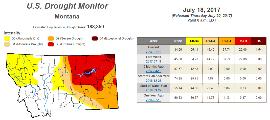
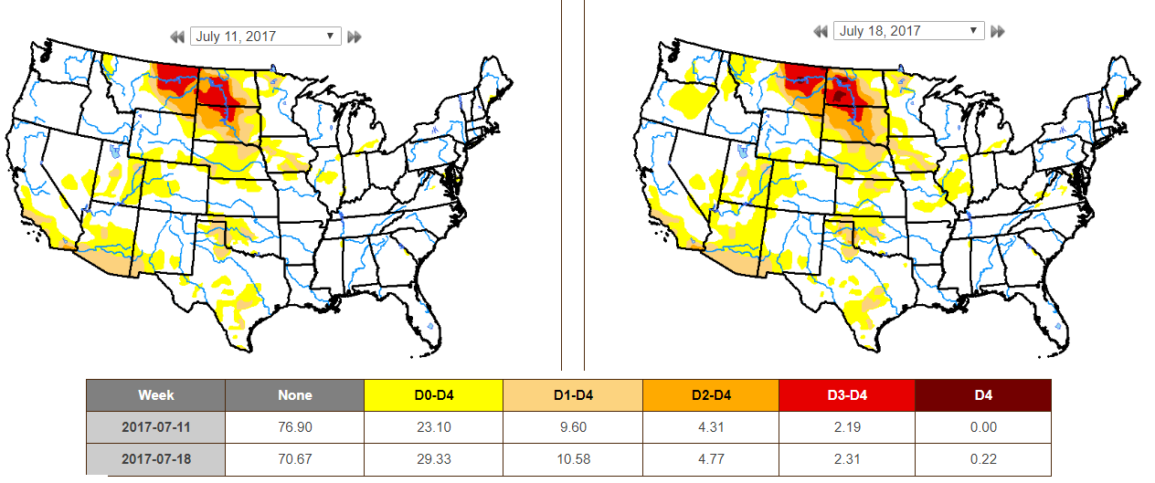
According to the US Drought Monitor, parts of Montana are now under an EXCEPTIONAL Drought. While nearly 2% is considered to be in an EXCEPTIONAL drought, 22% is under an EXTREME drought. Also, nearly 65% of the state is considered to be either abnormally dry or in some type of drought.
EXCEPTIONAL Drought in North Dakota
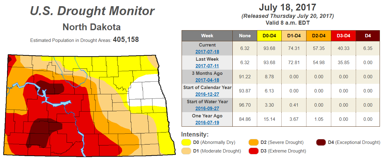
According to the US Drought Monitor, parts of North Dakota are now under an EXCEPTIONAL Drought. Interestingly, this is the first time since 2006! While a little more than 6% is considered to be in an EXCEPTIONAL drought, more than 40% is under an EXTREME drought, which is up from the nearly 36% last week. Also, nearly 94% of the state is considered to be either abnormally dry or in some type of drought.
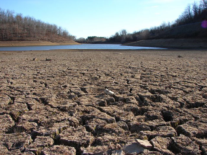
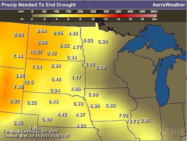
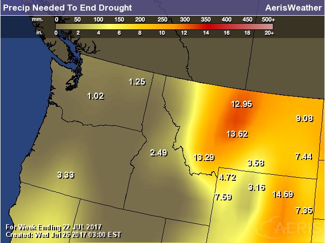
Rain Needed to End Drought
Exceptional and Extreme drought conditions are in place over parts of Montana and North and South Dakota due to several days/week of hot and dry weather. The image below suggests how much rain would be needed to end the drought, which suggests nearly 6" to 12" or more!
US Drought Monitor
According to the US Drought Monitor, drought conditions from July 11h to July 18th worsened slightly across the nation. Note that EXCEPTIONAL and EXTREME drought conditions (located across parts of Montana and parts of North and South Dakota increased from last week
_________________________________________________________________________
National Weather Outlook
Here's the weather outlook through early next week, which suggests that stormy weather will move into the Ohio Valley and Eastern US with strong to severe storms and locally heavy rainfall through through the end of the week. . A bubble of high pressure will slowly move through the Great Lakes Region, which will keep weather conditions quiet and comfortable there until next week. Meanwhile, monsoon storms will continue in the Southwest with areas of locally heavy rain and flash flood potential.
.gif)
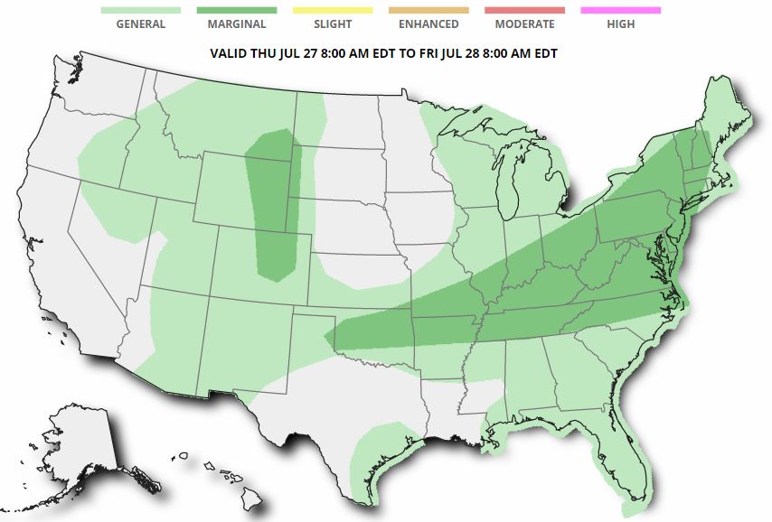
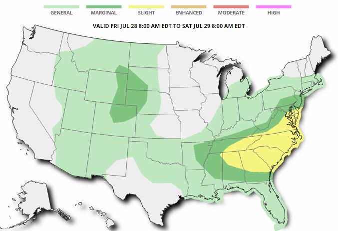
Severe Threats: Thursday & Friday
According to NOAA's SPC, there is a MARGINAL risk of severe storms has been posted across parts of the Ohio Valley/Mid-Atlantic/Northeast on Thursday. By Friday, the threat shifts farther south to include more of the Mid-Atlantic and parts of the Southeast. In these areas, large hail, damaging winds and locally heavy rains will be possible in these areas.
Excessive Rainfall Potential Thursday & Friday
According to NOAA's WPC, there is a risk of excessive rain through the end of the week with a MODERATE threat of excessive rainfall across parts of the Midwest/Central US today! SLIGHT risks of excessive rainfall move into the Ohio Valley and Southwest on Thursday. The threat of heavy rain continues in the Southwest on Friday, but develops across parts of the Mid-Atlantic/Northeast.
.gif)
.gif)
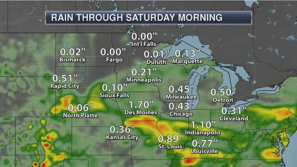
Localized Heavy Rain Threats
Excessive rainfall potential is possible across parts of the Midwest, Ohio Valley, Northeast and Mid-Atlantic States over the next couple days. The rainfall forecast suggests some 1" to 2"+ rainfall tallies through AM Saturday, which could lead to areas of localized flooding.
________________________________________________________
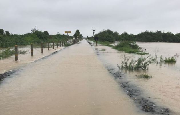
"Gujarat floods: The rainiest monsoon of the decade"
**This July saw the most rainfall for any July in the last decade.
**Gujarat has received 408mm in July (till July 25) the most rainfall received in July in the last decade.
**Eight districts have received more than 70% rains of their average annual rainfall.
**Gujarat has received 408mm in July (till July 25) the most rainfall received in July in the last decade.
**Eight districts have received more than 70% rains of their average annual rainfall.
"This monsoon has had the highest amount of rainfall seen till July 25 in the last decade. The state has received around 534.40mm, about 17mm more than in 2013, which had seen the most rainfall till July 25, in the last decade. This July saw the most rainfall for any July in the last decade. The state has received 408mm in July (till July 25) the most rainfall received in July in the last decade. The average rainfall for Ahmedabad in July is 299mm. In the 25 days of July 2017 so far, Ahmedabad has received 397mm of rain. The data further reveals that the apart from 2013 — when the state received 517.69 mm of rain till this point—the state did not more than 400mm of rain till July 25 in the last decade. Officials said that with August and September months still to come, four districts — Banaskantha, Morbi, Surendranagar and Patan — have received more than 100% of their annual rainfall figures. Eight districts have received more than 70% rains of their average annual rainfall."
(Image courtesty: IndiaTimes)
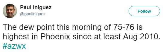
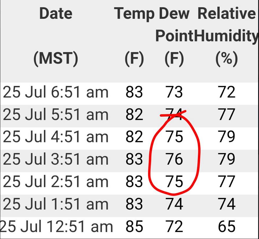
High Dewpoints in Phoenix, AZ
Thank to my good friend @pauliniguez for sharing this on Twitter, where dewpoints in Phoenix, AZ on Tuesday morning were in the mid 70s! Yea - that's tropical!! In fact, this was the highest the dewpoint has been in the area since at leat August 2010! This high moisture content can be attributed to the ongoing monsoon season in the Desert Southwest.
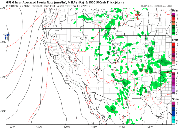
Monsoon Storms Continue
Here's the simulated radar from Thursday to Monday, which shows the potential of daily monsoon storms continuing across the region. Note that some of the storms could be a little on the strong side with gusty winds, dust storms and locally heavy rain, which could lead to localized flooding. The rainfall forecast below suggests that some areas could see up to 1" of rain or more through the end of the week!
 ________________________________________________________________________
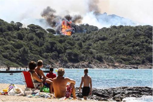
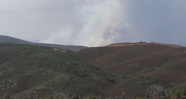
"Thousands Evacuated as Wildfires Rage in French Riviera"
"Authorities ordered the evacuation of 10,000 people as fires hopscotched around the Riviera for a third day Wednesday, tearing through the forest of La Londe-les-Maures. A violent fire took off in the dry Mediterranean forests around La Londe just before 11 p.m. the night before, and 540 firefighters were sent into the region, the prefect of the Var region, the top state official, said in a statement. About 3,000 campers were among the 10,000 evacuated from La Londe and nearby Bormes-les-Mimosas and La Lavandou, the prefect of the Var region, the top state official, said in a statement."
(Image Credit: NBCNews)
__________________________________________________________________
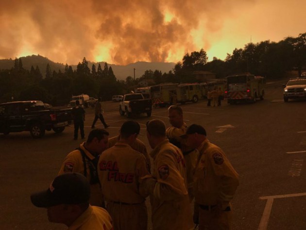
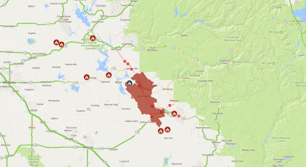
"Detwiler Fire Now 80,000 Acres"
"Firefighters dealt with another day of high temperatures and active fire behavior on the northeast corner of the Detwiler Fire. The fire is now estimated at 80,000 acres, still with 65 percent containment. The area of uncompleted line remains in the northeast corner between Coulterville and Briceburg. Firefighters continue to work aggressively throughout the day to reinforce containment lines. Steep and rugged terrain is making access difficult, but crews are making good progress."
(Detwiler Fire near Dogtown - photo by Renee Hiatt-Chaty Via SierraNews)
The Detwiler Fire located near Yosemite National Park in California has ballooned to a very large 80,000 acre fire since Sunday, July 16th. This fire has already consumed more than 130 structures; 63 homes, 67 minor structures and 1 commercial structure. A number of other homes and smaller structures have been damaged as well, but 1,500 other structures are being threatened now. There are almost 4,914 people working on the fire and it is only 65% contained at this point . Higher humidity levels are helping create better fire fighting conditions.
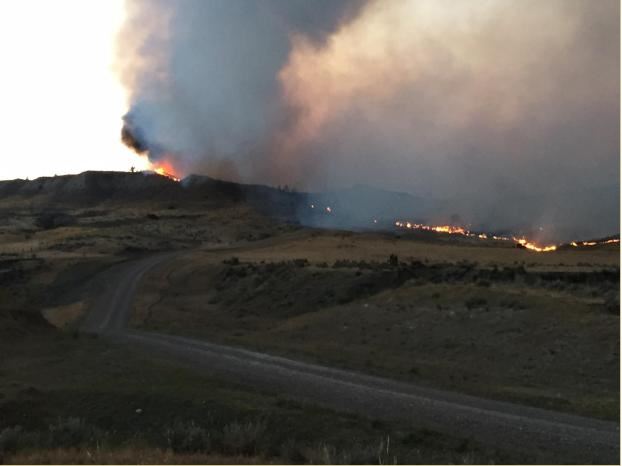
Lodgepole Complex - Montana
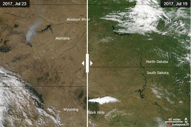
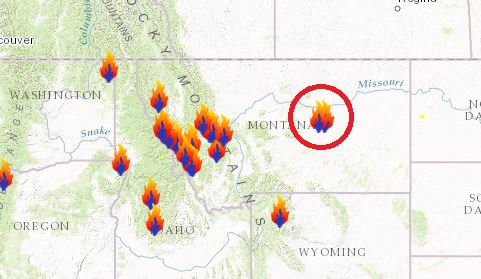
According to Inciweb, one of the largest fires currently burning in the Lower 48 is the Lodgepole Complex located 52 miles NW of Jordan, MT. This particular fire has consumed a whopping 270,000 acres and is only 36% contained. The fire is expected to be fully contained by Wednesday, August 2nd. This particular fire started on Wednesday, July 19th and quickly spread as hot, dry and windy weather created extreme fire behavior. Critical fire weather conditions are possible on Thursday and Friday as gusty winds combine with low humidity levels and a potential for thunderstorms.
(Image credit: Inciweb)
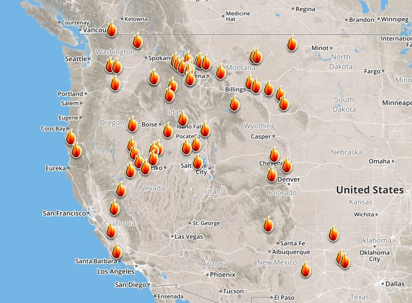
Ongoing Large Wildfires
Here's a look at the current wildfire map across the country. Recent hot and dry weather has helped to spark several wildfires across the Western US, while a few have also been popping up in the Eastern US.
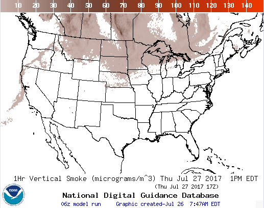
National Smoke Analysis
Here's the projected wildfire smoke concentration for midday Thursday, which suggests that smoke from wildfires burning across parts of Canada and the Western US could continue to linger around the High Plains and Upper Midwest. There also appears a very high concentration of smoke from fires burning across the western half of Canada. If you are in these areas, air quality could be a little poor, but these areas may also be enjoying very interesting looking sunrises/sunsets, which tend to look hazy or reddish-orange.
________________________________________________________________________
Sunny, dry and nearly perfect through Saturday
By Todd Nelson, filling in for DouglasWe're less than one month away from what is being dubbed as the "Great American Eclipse" and the anticipation is palpable. A total eclipse of the sun will stretch from Salem, Oregon to Columbia, South Carolina on August 21st. Interestingly, this will be the first solar eclipse in the Lower 48 since February 26, 1979; a span of more than 38 years! The next total solar eclipse in the U.S. won't happen until April 8, 2024 and will stretch from Texas to Maine. If you can wait around until September 14, 2099, a total eclipse of the sun will occur right over the Twin Cities - I'll be 117 years young.
I am happy to report that weather conditions will be nearly perfect over the next few days as a bubble of high pressure slowly drifts across the Great Lakes. Sunny, dry and comfortable temperatures will be with us through Saturday... You're welcome!
Lawns and gardens might start to look a little parched by the weekend, but a few late-day rumbles could help freshen things up by Sunday. Temps remain mild with no hot fronts in sight. I'll take it
________________________________________________________________________
Extended Forecast
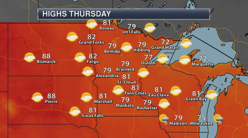
THURSDAY: Less humid. Few clouds. Winds: NNE 5. High: 83
THURSDAY NIGHT: Mostly cloudy, the gradual clearing. Winds: NNE 5. Low: 62.
FRIDAY: Another beauty. Bright blue sky. Winds: SE 5. High: 82
SATURDAY: Bingo! Go jump in a lake. Winds: S 5-10. Wake-up: 62. High: 83.
SUNDAY: Spotty late-day rumbles. Winds: WSW 5. Wake-up: 65. High: 83
MONDAY: Stray afternoon thundershower? Winds: E 5. Wake-up: 66. High: 85.
TUESDAY: Slight chance of a PM t-storm. Winds: SSW 5-10. Wake-up: 66. High: 84.
WEDNESDAY: Unsettled. A few thundery downpours. Winds: NNE 5. Wake-up: 68. High: 85
_______________________________________________________
_______________________________________________________
This Day in Weather History
July 27th
July 27th
1910: Giant hailstones fall in Todd and Wadena Counties. One stone weighed in at 5 pounds.
________________________________________________________
________________________________________________________
Average High/Low for Minneapolis
July 27th
July 27th
Average High: 83F (Record: 104F set in 1931)
Average Low: 64F (Record: 49F set in 1971)
Average Low: 64F (Record: 49F set in 1971)
Record Rainfall: 6.35" set in 1892
_________________________________________________________
_________________________________________________________
Sunrise/Sunset Times for Minneapolis
July 27th
July 27th
Sunrise: 5:53am
Sunset: 8:45pm
Sunset: 8:45pm
Hours of Daylight: 14hours & 52mins
Daylight LOST since yesterday: ~2 minutes and 12 seconds
Daylight LOST since summer solstice (June 20th): ~45 minutes
__________________________________________________________
Daylight LOST since summer solstice (June 20th): ~45 minutes
__________________________________________________________
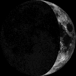
Moon Phase for July 27th at Midnight
2.3 Days Before First Quarter Moon
2.3 Days Before First Quarter Moon
_________________________
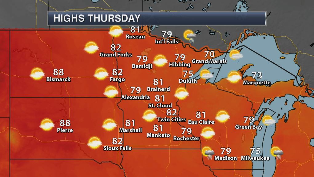
Weather Outlook For Thursday
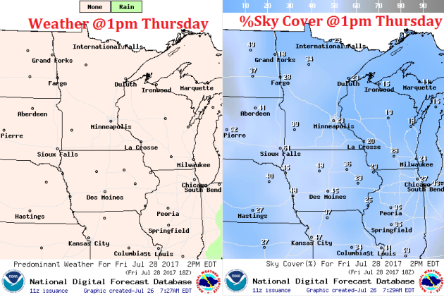
Thursday will be a very nice day across much of the state with highs warming into the 70s and low 80s. There may be a few more clouds across parts of the state, but we'll still have plenty of sun to work with. The other nice thing is that dewpoints values will be lower, so Thursday should shape up to be a fairly nice day!
Weather Outlook For Thursday
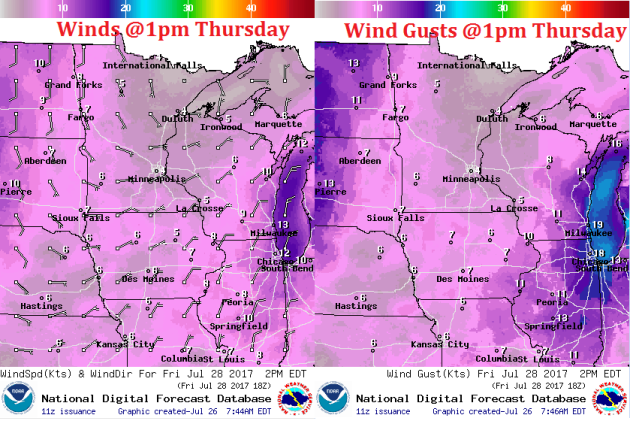
Winds will be very light across the region on Thursday, but they will turn out of the east-southeast, which will help to continue keeping mostly dry and less humid weather in place through the end of the week.
Here's the weather outlook for Thursday, which suggests dry and mostly sunny weather across the region.
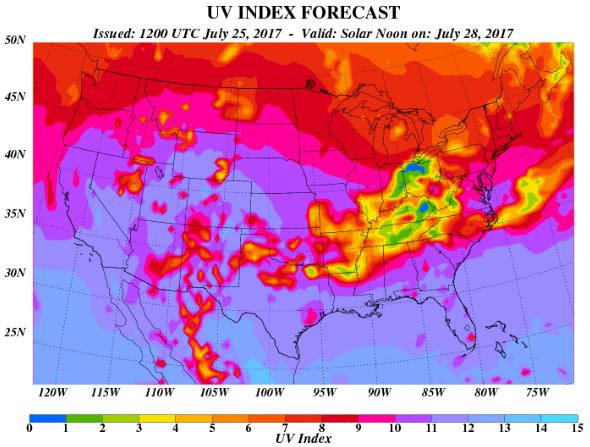
The UV Index for Thursday will be VERY HIGH, which means that it will only 15 to 25 minutes or less to burn unprotected skin. With that said, if you are planning on spending any extended length of time outside, make sure you wear appropriate attire and lather on the sun block!
 __________________________________________________________________________
Weather Outlook For Friday
Friday looks like another stunning with highs in the upper 70s to low 80s. Skies will remain mostly sunny with comfortable dewpoints. Enjoy!
UV Index for Friday - VERY HIGH
Mostly sunny skies on Friday will bring UV Index values into the VERY HIGH range once again. That means that your skin could burn in 15 to 20 minutes or less!
 _____________________________________________________________
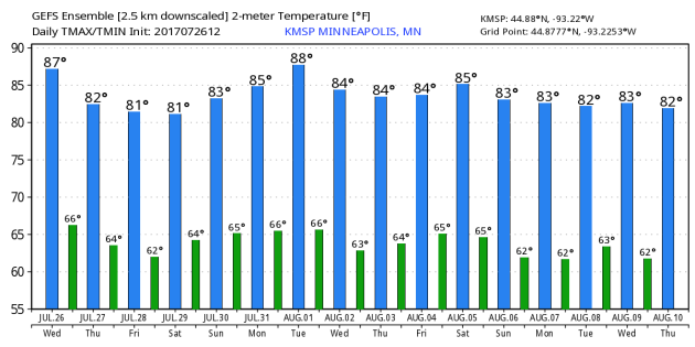
Minneapolis Temperature Outlook
Here's the temperature outlook through August 10th, which shows temperatures hovering in the 80s through the rest of the month. However, there could be a little dip into the mid/upper 70s through the first few days of August before temperatures sneak back up into the 80s for the first weekend of August.
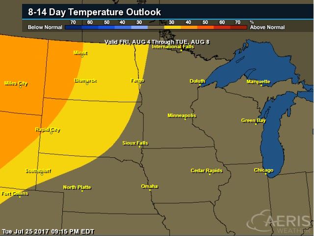
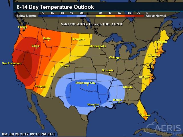
8 to 14 Day Temperature Outlook
According to NOAA's CPC, the extended temperature outlook from August 4th to August 8th suggests cooler than average temperatures moving south into the southern part of the country, while warmer than average temperatures will begin settling into the High Plains.
___________________________________________________________
Extended Temperature Outlook
According to NOAA's CPC, the extended temperature outlook through August 8th shows that a large chunk of the Southern US will be dealing with cooler than normal temperatures, while the western part of the country and the Eastern Seaboard will be above average.
Extended Temperature Outlook
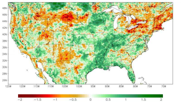
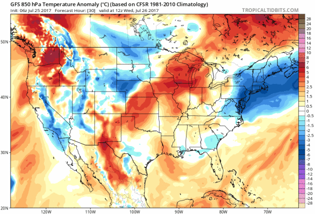
Here's the extended 850mb temperature anomaly loop into early next. This describes how warm or cold (from average) mid/low level temperatures will be over time. Note that the warmer oranges and reds will begin to settle in along the northern tier of the nation through the end of the month/early August, but there some cooler than average temps settling in across the Central US as well.
Weather Outlook Ahead
The weather outlook over the next couple of days shows stormy weather moving from the Midwest into the Ohio Valley and the Eastern US. Some of the storms could be strong to severe with locally heavy rain. There will also be continued monsoon storms in the Southwest that could lead to flash flooding.
.gif)
5 Day Precipitation Outlook
According to NOAA's WPC, the next several days could produce areas of locally heavy rainfall across many areas from the Desert Southwest to the Midwest and eastern half of the country. Some of the heaviest rainfall could add up to as much as 2" to 4"+, which could also lead to areas of localized flooding.
.gif)
____________________________________________________________________
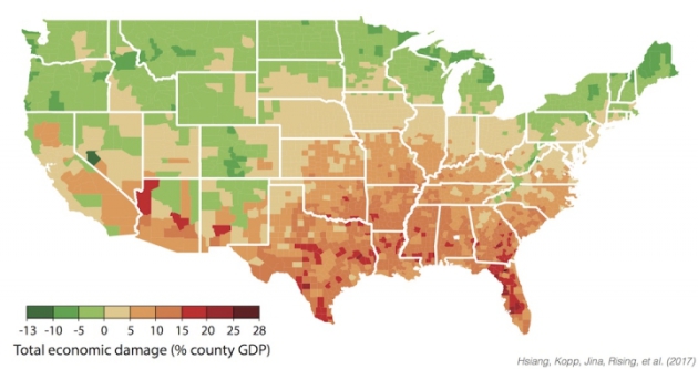
"Climate Change Will Hit the Poorest the Hardest in the U.S."
"Union County is tucked in northern Florida, half an hour north of Gainesville and an hour west of Jacksonville. It’s Florida’s smallest county, a mostly unremarkable landlocked stretch of pine forest interspersed with lakes. More than 15,000 people call it home, working largely in healthcare, transportation and public administration. The state prison and Target distribution center are among the county’s notable employers. The unemployment rate is low at around 4 percent, but most jobs aren’t high paying. As a result, Union County is Florida’s poorest county by per capita income.' New research shows there’s something else that makes Union County unique: it’s ground zero for the economic damage that climate change will cause in the U.S."
(County-level annual damages in median scenario for climate during 2080-2099 under business-as-usual emissions trajectory (RCP8.5). Negative damages indicate economic benefits.
Click image to enlarge. Credit: Hsiang, et al. 2017)
Click image to enlarge. Credit: Hsiang, et al. 2017)
________________________________________________________________
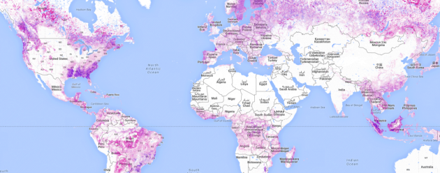
"A Nebraska-Sized Area of Forest Disappeared in 2015"
"A Nebraska-sized chunk of the world’s forests was decimated in 2015 because of wildfire, logging and expanding palm oil plantations, according to a new study. The loss is part of a continuing trend of deforestation that could have devastating implications for the climate. About 49 million acres of forest disappeared worldwide in 2015, mainly in North America and the tropics, putting the year’s global deforestation level at its second-highest point since data gathering began in 2001. In all, the globe lost 47 percent more forested land in 2015 than it did 16 years ago, according to the study by Global Forest Watch."
(Areas shaded in pink show points that have lost trees at least 16 feet in height due to deforestation, wildfire or some other cause of mortality between 2001 and 2015. Credit: Global Forest Watch)
"Cassini Snaps Dazzling Photo of a 'Ring-Bow' in Saturn's Rings"
"Saturn's glorious rings take center stage in a beautiful new photo by NASA's Cassini spacecraft, which scientists dubbing it a "ring-bow." "Although the rings lack the many colors of the rainbow, they arc across the sky of Saturn," NASA officials wrote in a photo description today (July 25). "From equatorial locations on the planet, they'd appear very thin since they would be seen edge-on. Closer to the poles, the rings would appear much wider; in some locations (for parts of Saturn's year), they would even block the sun for part of each day." Though NASA released the image today, Cassini actually captured it on April 10, when the probe was about 680,000 miles (1.1 million kilometers) from Saturn's cloud tops, NASA officials said. Each pixel is about 43 miles (69 km) wide, they added."
(This image of Saturn’s rings was taken by NASA’s Cassini spacecraft on April 10, 2017, when the probe was about 680,000 miles (1.1 million kilometers) from the gas giant. Credit: NASA/JPL-Caltech/Space Science Institute)

"California Shows How States Can Lead on Climate Change"
"California, which has long been a pioneer in fighting climate change, renewed its commitment to reducing greenhouse gas emissions last week by extending, to 2030, its cap-and-trade program, which effectively puts a price on emissions. It’s a bold, bipartisan commitment that invites similarly ambitious policies from other states, and it sends a strong signal to the world that millions of Americans regard with utmost seriousness a threat the Trump administration refuses to acknowledge, let alone reckon with. The cap-and-trade program, which had been set to end in 2020, is the most important component of California’s plan to reduce planet-warming emissions by 40 percent (from 1990 levels) by 2030. The extension, along with a companion bill to reduce local air pollution, was passed by a two-thirds majority of the State Legislature, including eight crucial votes from Republicans. They defied a Republican president who has not only reneged on America’s global climate commitments, but has tried to undo every climate policy put into place by former President Barack Obama."
(Image Credit: Rose Wong via NYTimes)

"A Comic Strip Mirrors the Ravages of Climate Change"
"The newspaper comic strip “Arctic Circle,” by the environmentally minded cartoonist Alex Hallatt, is about talking penguins and their fellow creatures living in the north. Starting Monday, under a caption that says “An Inconvenient Truth,” the menagerie will find their world shrinking and their conversations will be about global warming. Readers will see the drawings diminish to nothing by Friday as a snow bunny muses, “Climate change will lead to habitat loss and the extinction of many species.”Miss Hallatt created the strips to observe the arrival of the documentary “An Inconvenient Sequel: Truth to Power,” in theaters on Friday. The film is a follow-up to the 2006 Oscar-winning documentary featuring Al Gore. Miss Hallatt has no official connection to the film."
(The cast of “Arctic Circle,” by the cartoonist Alex Hallatt, includes three penguins, a polar bear, a lemming and a bunny. Cre(ditAlex Hallatt/King Features Syndicate))

_______________________________________________________________________
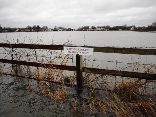
"Climate change brings one-in-three chance of record rainfall, warns Met Office"
"There is now a one-in-three chance of record rainfall hitting part of England and Wales each winter, according to new Met Office study which highlights the risk of major flooding as the climate warms. The researchers warned that global warming would change the risk of extreme weather and suggested politicians should bear this in mind when planning to protect the public, businesses and infrastructure. A series of storms in the winter of 2013-14 caused widespread flooding and about £1bn-worth of damage in the Thames river valley. Writing in the journal Nature Communications, the Met Office team said they had used computer models of the climate to show that those storms “could have been anticipated”."
(A series of storms in the winter of 2013-14 caused widespread flooding Getty via Independent)
"Climate change challenges sinking city of Venice"
"The Italian city of Venice is prone to frequent flooding because it has sunk five inches over the last century, but it is also grappling with a new challenge: sea-level rise, caused by climate change, which increases the severity. NewsHour Weekend Special Correspondent Christopher Livesay reports on the risks, and Italy's plans to mitigate them, as part of our series “Peril and Promise,” on the challenge of climate change."
(Image Credit: PBS)

Thanks for checking in and don't forget to follow me on Twitter @TNelsonWX

No comments:
Post a Comment