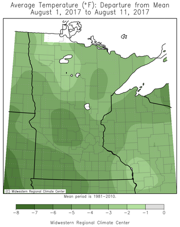
Cool Start To August
Even
though we started the month off with highs around 90 in the Twin
Cities, periods of cooler weather have helped the average temperature so
far be below average across the entire state. In parts of the state,
average temperatures are ranging from between 3-5 degrees below average.
Through the 11th, the average temperature in the Twin Cities was 69.4
degrees, which is 3.2 degrees below average.
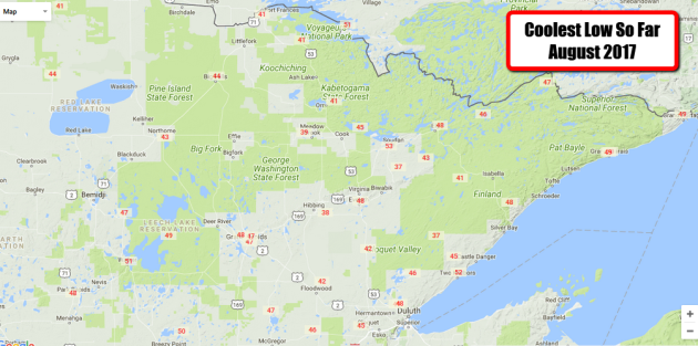
The
cool conditions have been observed in our lows as well, with mornings
in the 30s across parts of northern Minnesota this month. The coolest
low so far this month has been in Brimson and Embarrass, each hitting
37. Hibbing got down to 38 on the 5th. This is really starting to make
you think fall (and pumpkin spiced everything) is right around the
corner, doesn't it?
_______________________________________________
What Does Probability of Precipitation Mean?
By Paul Douglas
Communicating the weather forecast can be just as challenging as predicting
tomorrow's weather. Meteorologists look at current data and weather models before developing a vision of what
tomorrow's
sky may look like. Of course weather changes (rapidly) so the forecast
needs to reflect those expected changes. We are using words and symbols
to reflect how the atmosphere should evolve over time.
During the
summer I refer to expected showers as "isolated", "scattered",
"numerous" - or if everyone will get wet, "rain". A 30 percent
probability doesn't mean 30 percent of us will get wet, or it'll rain 30
percent of the time. It means that on 3 out of 10 days a single point
will pick up .01 inches of rain or more. That's why I avoid
probabilities.
Showers and T-storms will be numerous today, keeping us cooler than yesterday. A shower may spill into
Monday; more numerous T-storms return late
Tuesday into
Wednesday; again
on Friday.
Next
weekend looks sunnier and warmer, and I'm stubbornly persistent in my
prediction of sticky 80s and a few 90s for the State Fair. Wait for it.
_______________________________________________
Twin Cities Extended Forecast
SUNDAY: Few showers, storms. High 72. Low 60. Chance of precipitation 60%. Wind S 5-10 mph.
MONDAY: Patchy clouds, stray shower. High 75. Low 61. Chance of precipitation 30%. Wind SE 5-10 mph.
TUESDAY: Partly sunny, T-storms arrive late. High 80. Low 64. Chance of precipitation 40%. Wind SE 8-13 mph.
WEDNESDAY: Lingering showers, T-showers. High 79. Low 62. Chance of precipitation 60%. Wind S 10-15 mph.
THURSDAY: Sunnier. Drier. Better outdoor day. High 82. Low 63. Chance of precipitation 20%. Wind NW 5-10 mph.
FRIDAY: Another round of T-storms. High 80. Low 62. Chance of precipitation 50%. Wind S 7-12 mph.
SATURDAY: Warm sunshine as winds diminish. High 83. Low 64. Chance of precipitation 10%. Wind NW 7-12 mph.
_______________________________________________
This Day in Weather History
August 13th
1964: Minnesota receives a taste of fall, with lows of 26 in Bigfork and 30 in Campbell.
_______________________________________________
Average Temperatures & Precipitation for Minneapolis
August 13th
Average High: 81F (Record: 98F set in 1880)
Average Low: 63F (Record: 48F set in 1997)
Average Precipitation: 0.14" (Record: 2.05" set in 2007)
________________________________________________
Sunrise/Sunset Times for Minneapolis
August 13th
Sunrise: 6:12 AM
Sunset: 8:22 PM
*Length Of Day: 14 hours, 9 minutes and 9 seconds
*Daylight Lost Since Yesterday: ~2 minute and 43 seconds
*Next Sunrise At/After 6 PM: August 2nd (6:00 AM)
*Next Sunset At/Before 8 PM: August 26th (8:00 PM)
_______________________________________________
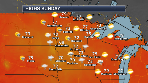
Minnesota Weather Outlook
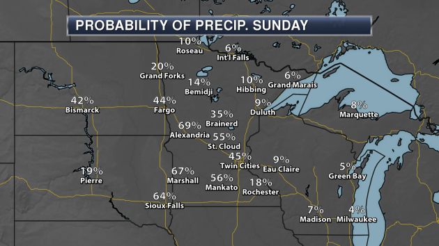
Rain
will be possible Sunday across southern Minnesota - more steady
throughout the day for places like St. Cloud, Alexandria and Marshall
but moving east into locations like the Twin Cities and Rochester by the
afternoon hours. Where the rain falls, temperatures will be cooler,
only making it into the low 70s across southern Minnesota. Alexandria
might not make it out of the 60s! Across northern Minnesota, sunnier
skies are expected with some areas climbing into the upper 70s for
highs.
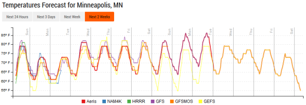
We
stay relatively cool into early in the week in the Twin Cities, with
highs in the 70s expected. Temperatures should climb back into the 80s
for a majority of the middle and end of the week, which will be slightly
above average at times. You may notice, however, that models aren't
currently forecast 90s at this point in the next couple weeks.
Rain
chances Sunday will be the greatest over southern and western
Minnesota. Rain chances start to taper off the further north and east
that you go. This graphic is valid for the 7 AM to 7 PM time frame on
Sunday.
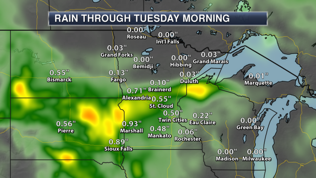
This
system could produce some half inch to inch rainfall totals across
parts of southern and central Minnesota through early next week.
We
look to be in an active pattern this week, with more rain in the
extended forecast. The potential for rain increases once again Tuesday
Night into Wednesday and into late in the week. Rainfall totals in the
Twin Cities could approach an inch and a half by next weekend.
_______________________________________________
National Weather Outlook
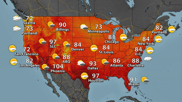
Sunday's Forecast
Cool
weather (for this time of year) will continue to sit across a good
potion of the nation Sunday, with highs that are a good 5-15 degrees
below average across parts of the Upper Midwest and Central Plains.
Warmer than average temperatures will be found across parts of central
and southern Texas, as well as parts of Montana. A stalled frontal
boundary will help bring rain - heavy at times - to parts of the South
Central and Southeast United States. A cold front will be moving through
the Northeast, bringing a shot of cooler air and some lingering early
day showers. A system will be moving into the North Central U.S.,
bringing rain and cool temperatures.
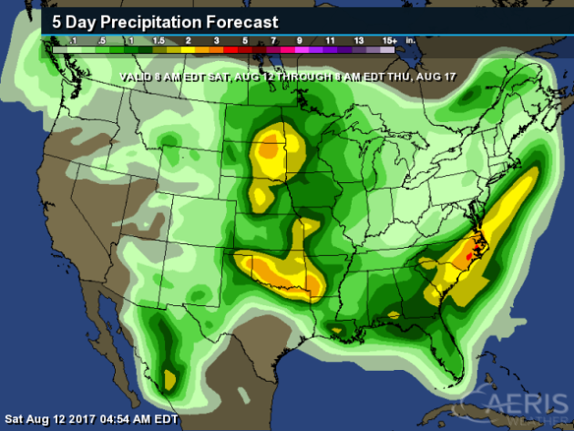
Three
pockets of heavy rain is possible through Thursday morning across parts
of the nation: in the Northern Plains, Southern Plains, and in the
Mid-Atlantic. In each of these areas, rainfall amounts of 2-4" will be
possible.
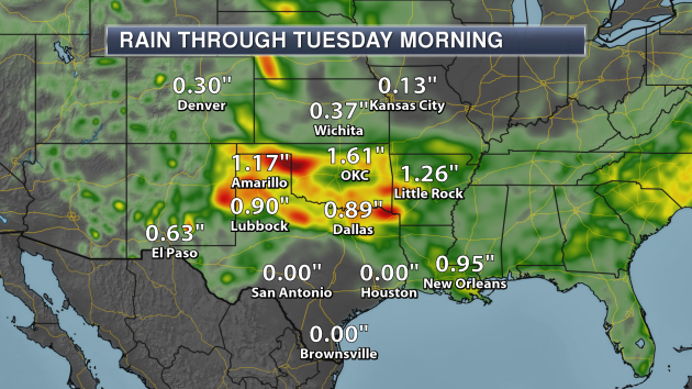
Rounds
of heavy storms could produce heavy rain across parts of Oklahoma and
Texas through Tuesday morning. Some areas have already been hit by heavy
rain over the past few days, so this could lead to a flash flood
threat, especially in Oklahoma and along the Red River.
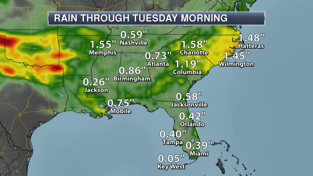
With
a weak cold front stalling across portions of the region into early in
the week, rainfall totals could top an inch across portions of the
Carolinas through Tuesday morning.
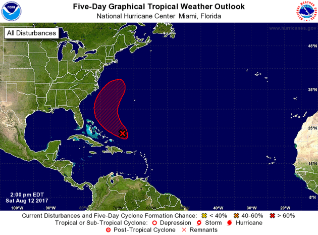
We
also continue to have our eyes on the Atlantic, where a low pressure
center has about a 60% chance of becoming a tropical system in the next
48 hours, and a 70% chance in the next five days. The good news is that
models continue to indicate that whether or not this system becomes a
tropical depression, it should turn away from the lower 48.
_______________________________________________
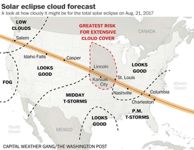
Cloudy For The Eclipse?
The Capital Weather Gang
released their latest forecast for the solar eclipse on August 21st.
The best chance of cloud cover appears to be over the central U.S. at
the moment. More: "
The possibility of an approaching cold front
raises the risk of clouds for Washington and Oregon. Smoke in Pacific
Northwest could be less extensive as the front could push smoke north
into Canada. Possible storm system in center of country poses greatest
risk for extensive cloud cover."
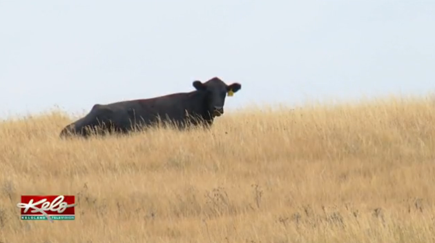
Poisoned Cattle From Drought
With
drought continuing over parts of the central U.S., farmers are not only
having to worry about their crops. Livestock is also at risk, and
there's even the threat of poisoned animals.
More from KELO-TV: "
"With
the creeks down and the ponds getting lower, because of the evaporation
livestock mortality could be the next thing," Schoon said. That's
because the water quality in this part of the state is becoming a
serious issue. Lyman County rancher Quint Garnos says his neighbor lost
a few cattle already. "When the dams get real low, the minerals get
higher and it's poisonous to the cows," Garnos said."
Wildfire Danger On Lumber Lands
Due
to the ongoing drought in Montana, at least one lumber company is
having to take action to prevent fires on their public access lands.
More from the Western News: "
Citing
increasing risk of wildfire, F.H. Stoltze Land and Lumber Company on
Aug. 7 imposed restrictions on public access to lands it owns in
Flathead, Lake and Lincoln Counties that are in addition to Stage II
Fire Restrictions (fwp.mt.gov/news/drought/definitions.html#stageII)
already in place. The additional restrictions include no use of
motorized vehicles on or off road (unless on an open public road); no
use of any internal combustion engines on any lands; no camping; no
fires of any kind; no smoking; and no fireworks."
Increase In Indian Farmer Suicides Due To Climate Change
A
new study shows a link between warming temperatures in the growing
season in India and an increasing amount of suicides among farmers in
the country. More from
Climate Central: "
A
suicide epidemic among India’s farmers has shaken the country and
contributed to a doubling of the nation’s suicide rate since 1980. It’s
a widespread and intensely personal issue, one that has been difficult
to tease out the root source. Debt, mental health, lack of social
services, weather vagaries and even media coverage have all been put
forward as part of the problem. Now, recent research published in the
Proceedings of the National Academy of Sciences suggests that climate
change could also be playing a role." (Image:
An Indian farmer plows his field. Credit: Kannan Muthuraman/flickr)
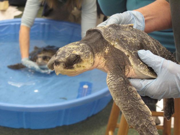
Sea Turtle Deaths Attributed To Climate Change
Warmer
waters are apparently luring sea turtles further up the Atlantic coast
during the summer, however that could lead to trouble for them in the
fall once it starts to cool down. More from
Popular Science: "
Every
year, young sea turtles migrate up the East Coast to spend the summer
foraging in northerly waters. Sometimes, they wind up in the Gulf of
Maine, which stretches from Cape Cod Bay to Nova Scotia. As the weather
cools, the turtles, including endangered Kemp’s ridley and loggerhead
turtles, begin to swim south." (Image: A cold-stunned Kemp’s ridley sea turtle waits its turn to be slowly warmed up in a kiddie pool. Julie O’Neil)
_______________________________________________
Thanks for checking in and have a great Sunday! Don't forget to follow me on Twitter (@dkayserwx) and like me on Facebook (Meteorologist D.J. Kayser)!
- D.J. Kayser


No comments:
Post a Comment