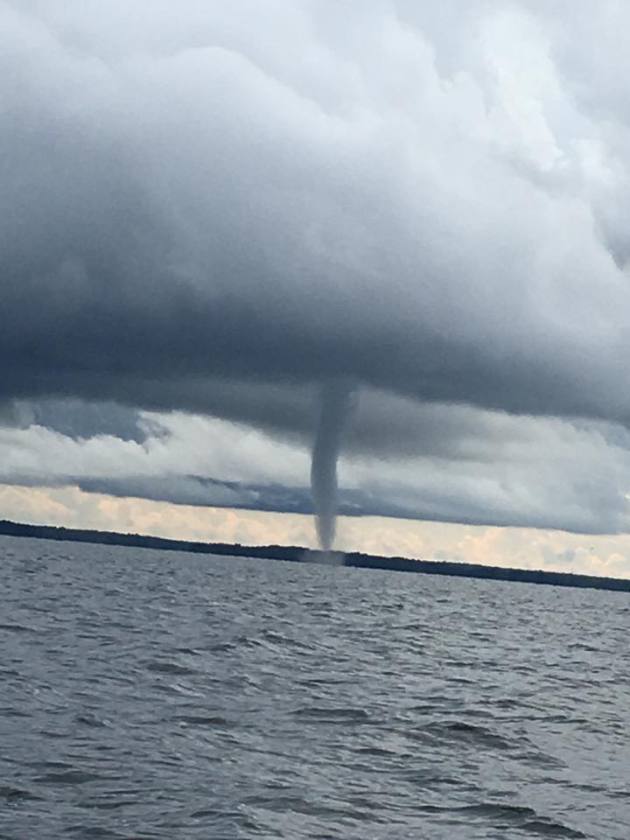
Minnesota Waterspout?
Take a look at this picture from Cut Foot Sioux Resort located on Lake Winnibigoshish in northern Minnesota. This waterspout happened a little after 5pm on Thursday evening. WOW!
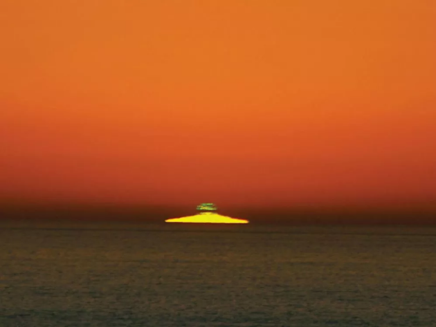
"Every sunset ends with a green flash. Why is it so hard to see?"
"The finale of every sunset is green. Try to catch it, if you can. The story of the so-called green flash begins by answering this question: Why is the sky blue? Sunlight contains every visible color, each with its own wavelength. Light travels as ripples, with crests and valleys; wavelength is the distance between the crests. The shorter the wavelength, the steeper the ripples. Of the three primary visual colors—blue, red, and green—blue has the shortest wavelength, and red the longest. As sunlight hits Earth, blue light’s steep waves cause particles in the air to scatter it almost totally, turning our skies cerulean. The leftovers combine to create the sun’s yellow glow. At sunset, colors fade at varying rates. Just before the sun vanishes, the red light’s shallower ripple causes it to shoot overhead and miss your eyes. Green, with its steeper wavelength, remains the sole color survivor, if only for a second."
(The elusive green flash. photograph by Nigella Hillgarth via Popular Science)
"A member of the Cubs ground crew went on a tarp riding adventure"
"The Cubs and Diamondbacks went through multiple rain delays on Thursday, which — spoiler alert — turned out to be a lot of fun for each team’s bullpen. But for one member of Chicago’s grounds crew, the rain delay was enjoyable for a completely different reason. Well, enjoyable if they like taking a ride on a magic tarp-et. In the process of unfurling the tarp, one worker got left behind and trapped in the middle. Unlike other instances of tarp rolling or unrolling gone wrong, this crew member didn’t get rolled up in it or stuck underneath things, and it actually looks like it was a pretty fun time. This isn’t the first time the Cubs have had some problems with tarp management, but at least in this instance the tarp got put on the infield in the right direction. This mistake looks like it was so much fun for this employee and no one got hurt, so all in all things turned out okay. Next time it rains the Cubs should charge people to go tarp surfing."

____________________________________________________________________
Simulated Radar Ahead...
Here's the simulated radar from Sunday to Thursday, which shows spotty rain showers pushing through the region on Sunday and again later in the week. Note that the best chance of a little more widespread rainfall looks to move in later in the week.
Rainfall Potential Ahead
The rainfall forecast through PM Thursday, which shows fairly decent rainfall potential across the state with up to 0.25" possible. It will be nice to get a little rain for lawns and gardens, but it likely won't be enough to keep them happy. Manual watering duties will likely still be needed.
___________________________________________________________________________
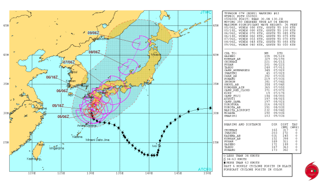
NORU in the Western Pacific
The Joint Typhoon Warning Center continues to track Typhoon Noru, which as of early Saturday was still equivalent to a category 1 hurricane as it neared the southern coast of Japan. Strong winds and heavy rainfall will be expected in some areas as Noru nears the coast and moves inland.
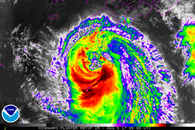
Here's the official track for NORU, which has it moving northeast across southern Japan as it slowly diminishes. Strong, gusty winds and locally heavy rain/flooding can't be ruled out.
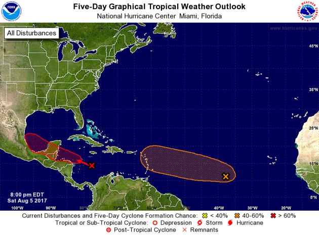
Activity in the Atlantic
The National Hurricane Center is watching a wave of energy in the Atlantic basin that has a HIGH probability of tropical formation over the next 5 days. If this particular wave develops into a tropical storms, its name would be Franklin. Stay tuned...
.gif)
Weather conditions in the Atlantic basin are starting to heat up a little more with 2 different waves that the National Hurricane Center is watching. 1 wave in the Central Atlantic has a MODERATE chance of tropical formation over the next 5 days, while the other in the Caribbean has a HIGH chance over the next 5 days.
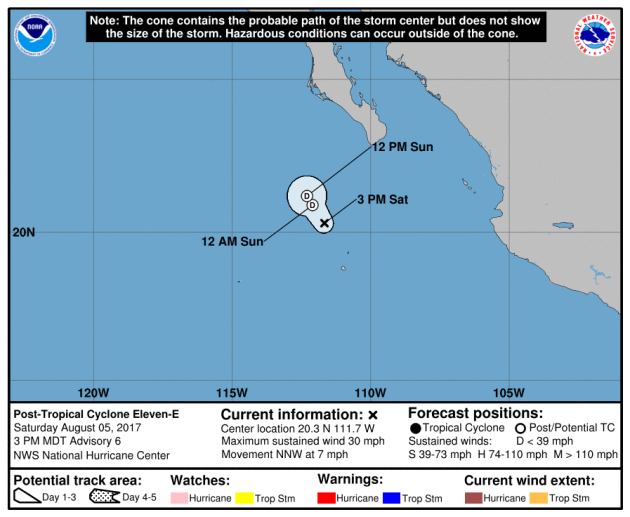
Tracking Post-Tropical Depression ELEVEN
According to NOAA's NHC, Post-Tropical Depression ELEVEN continues in the Eastern Pacific. This storm continues the trend of what has been a fairly active trend in the basin this season. Thankfully, none of the storms has hit any major land masses.
.gif)
Tracking Post-Tropical Depression ELEVEN
Here's the official track of Post-Tropical Depression ELEVN, which shows it drifting north and diminishing through Sunday.
.png) __________________________________________________________________________
__________________________________________________________________________
"A surprise hailstorm destroys an airplane in Turkey"
"The estimated size (in inches) of hail stones that fell on Istanbul last week. The severe thunderstorm injured at least 10 people as it tore through Turkey’s most populous city, forcing people to abandon their cars because of widespread flash floods. While the rain and wind were impressive, it was the size and scope of the hailstorm that left a lasting impression, in more ways than one. The situation could have reached disastrous levels after a Ukrainian pilot, having just taken off from Istanbul’s airport, encountered the hailstorm at an altitude of 4,000 feet. This was the result of that encounter. Amazingly, the experienced pilot was able to land safely back in Istanbul, using only his instrumentation for guidance."

______________________________________________________________
PRELIMINARY 2017 Tornado Map
It certainly has been a fairly active first half of 2017 with 1202 preliminary tornado reports through August 3rd. Note that this is the most tornadoes through August 3rd since 2011, when there were 1,682 reports. The map below shows the distribution of the tornadoes so far this year.
.gif) PRELIMINARY 2017 Tornado Count
PRELIMINARY 2017 Tornado Count
According to NOAA's SPC, the PRELIMINARY 2017 tornado count is 2012 (through August 3rd). Note that is the most active year for tornadoes since 2011, when there were 1,668 tornadoes. Keep in mind there was a major tornado outbreak in the Gulf Coast region from April 25-28, 2011 that spawned nearly 500 tornadoes, some of which were deadly. That outbreak is known as the Super Outbreak of 2011 and has gone down in history as one of the biggest, costliest and one of the deadliest tornado outbreaks in history.
.png)
____________________________________________________________
_____________________________________________________________________
According to NOAA's SPC, the PRELIMINARY 2017 tornado count is 2012 (through August 3rd). Note that is the most active year for tornadoes since 2011, when there were 1,668 tornadoes. Keep in mind there was a major tornado outbreak in the Gulf Coast region from April 25-28, 2011 that spawned nearly 500 tornadoes, some of which were deadly. That outbreak is known as the Super Outbreak of 2011 and has gone down in history as one of the biggest, costliest and one of the deadliest tornado outbreaks in history.
____________________________________________________________
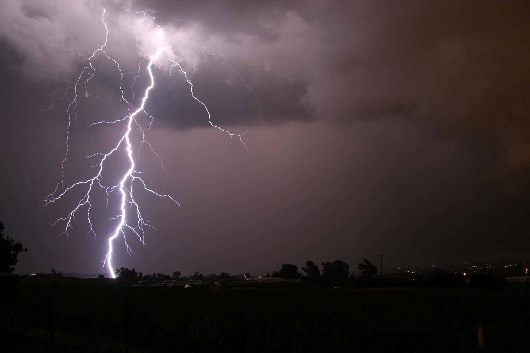
"This is what happens when you're struck by lightning"
"The odds are one in a million that you will be struck by lightning this year. Still, on average, about 300 people in the U.S. are injured and 30 are killed each year, according to the National Weather Service. On Tuesday, a lightning strike injured three workers at Park Tudor High School. One of the men went into cardiac arrest and was revived after 12 minutes with the help of a school officer, William Hagy, who performed CPR. All three are doing well now, according to a spokesman from St. Vincent Indianapolis Hospital. Lightning is one of the top three storm-related killers in the United States, according to the National Weather Service, but it is also one of the least understood weather phenomena. Each event, however, certainly starts with a growing thunderstorm cloud, a negative charge building in the bottom of the cloud and a positive charge in the ground below. When the difference between charges grows too great, the insulating capacity of the air breaks down and electricity is discharged."
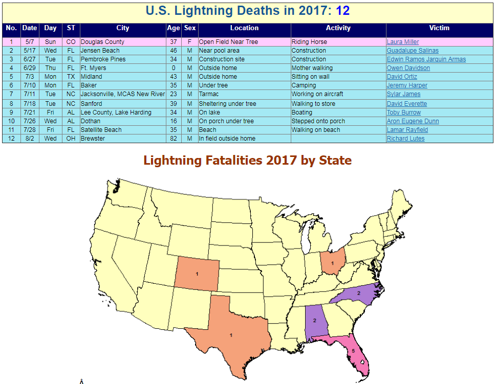
Lightning Fatalities So Far in 2017
According to NOAA, there have been 12 lightning fatalities so far this year with the most recent happening on August 2nd in Brewster, OH. Note that there have been 5 deaths in Florida, which is known as the lightning capital of the world!
_____________________________________________________________________
2.) Heavy rain over parts of South Texas, Thu-Fri, Aug 10-11.
3.) Heavy rain across portions of southern mainland Alaska, Tue-Wed, Aug 8-Aug 9.
4.) Much above-normal temperatures across portions of the Pacific Northwest, the northern Rockies, and the northern Great Basin, Mon-Fri, Aug 7-Aug 11.
5.) Heavy rain across portions of the central and southern Plains, the Middle Mississippi Valley, the Lower Mississippi Valley, Sat, Aug 12.
6.) Slight risk of much above-normal temperatures for portions of the central and northern Great Basin, the Northern Plains, the Northern Rockies, California, and the Pacific Northwest, Sat-Mon, Aug 12-Aug 14.
7.) Moderate risk of much above-normal temperatures for portions of the Pacific Northwest, the Northern Rockies, and the Northern Great Basin, Sat, Aug 12.
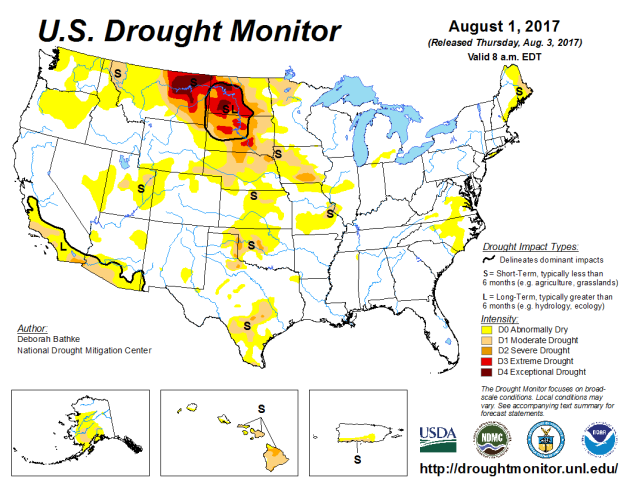
8.) Severe Drought across parts of the Great Plains, the Middle Mississippi Valley, California, the Southwest, and Hawaii.
.png)
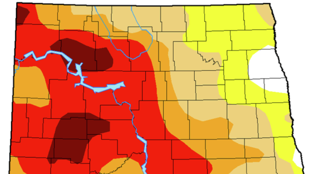
"The drought plaguing eastern Montana and much of North and South Dakota came on quickly and is intensifying, leading ranchers to sell their cattle and farmers to harvest early whatever crops that have grown so far this summer. Just three months ago, no areas of moderate drought were recorded in the Northern Plains region by the U.S. Drought Monitor at the University of Nebraska-Lincoln. But July's soaring temperatures and lack of rain quickly parched the soil and dried up waterways, creating what climatologists call a "flash drought." Now, 62 percent of North Dakota, more than half of South Dakota and 40 percent of Montana are in severe, extreme or exceptional drought, according to the drought monitor's weekly report released Thursday. There are also pockets of drought in the Southern Plain states of Nebraska, Iowa, Oklahoma and Texas. In Montana, 12 percent of the state's land is experiencing "exceptional drought," meaning widespread crop and pasture losses and water-shortage emergencies, mainly in the northeastern part of the state. "We would expect to see conditions that bad once or twice in 100 years," said Deborah Bathke, a climatologist at the University of Nebraska-Lincoln's National Drought Mitigation Center and a co-author of the drought monitor."
See more from AgWeb.com HERE:
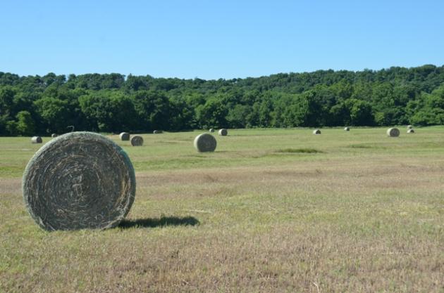
"Reports of some wheat fields yielding less than 20 bushels per acre and moisture totals for the year comparable to the drought year of 1988 have prompted Mark Watne, president of North Dakota Farmers Union, to request federal disaster payments for crop and livestock farmers. “There have been great efforts to get hay and forage into the hands of ranchers,” Watne said in a press release Thursday. “That won’t fix the financial disaster that is looming.” Watne said the drought disaster includes parts of three states and is comparable to the 1980s. In 1988, the average wheat yield in North Dakota was 14 bushels per acre, according to the North Dakota Wheat Commission website. That is the lowest on record since 1980. The average yield for the last 10 years has been 41.7 bushels per acre."
See more from JamestownSun.com HERE:
(The U.S. Drought Monitor map issued Thursday shows severe drought expanding east across southern Stutsman County, shown in orange on the map. Northern Stutsman County is in moderate drought conditions, shown in tan. Yellow represents abnormally dry areas, while red is extreme drought and the darkest area reflects exceptional drought. Courtesy / National Drought Mitigation Center)
"Not only are these drought conditions impacting corn, soybean, and spring wheat conditions, this intensity is also reflected in the pasture and range conditions released weekly by USDA NASS. Over 50 percent of the pasture and range is in critical conditions, rating poor and very poor, in Montana, North Dakota and South Dakota. Figure 1 maps the degree of pasture and range conditions that were listed as poor and very poor in the Crop Progress report on July 31, 2017. Inadequate pastures have led to cattle moving south much earlier and at lighter weights than are typically seen. Cattle on Feed for June showed large increases in the year over year figures in categories under 800 pounds. Cattle placed under 600 pounds were up 30 percent compared to 2016. In addition, USDA had announced multiple initiatives allowing for emergency grazing on Conservation Reserve Program lands and there have been reports of roadside baling."
See more from DairyHerd.com HERE:
____________________________________________________________________
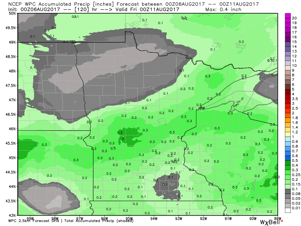
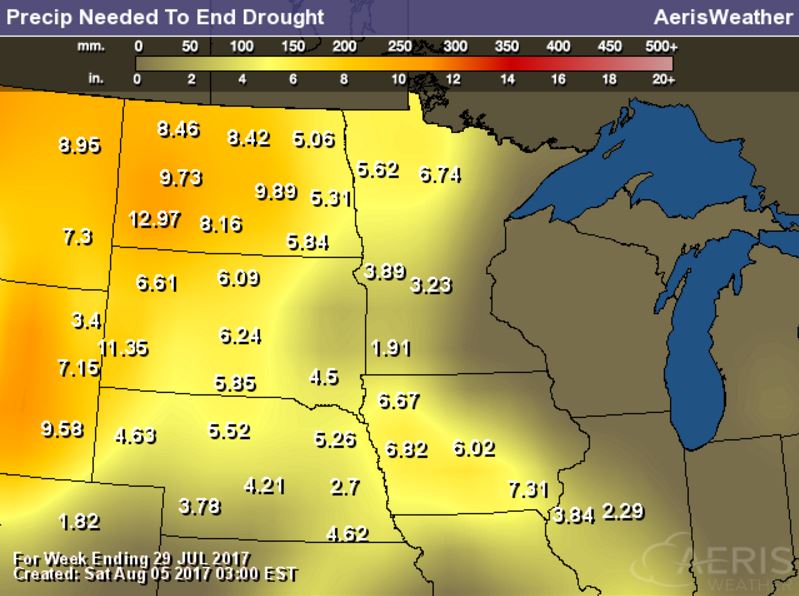
Rain Needed to End Drought
Exceptional and Extreme drought conditions are in place over parts of Montana and North and South Dakota due to several days/week of hot and dry weather. The image below suggests how much rain would be needed to end the drought, which suggests nearly 6" to 12" or more!
_________________________________________________________________________
National Weather Outlook
Here's the weather outlook through the end of next week, which shows somewhat active weather conditions across parts of the central and eastern US. Scattered showers and storms will bring areas of locally heavy rain to some of these locations. Also keep in mind that some of these storms could be strong to severe.
.gif)
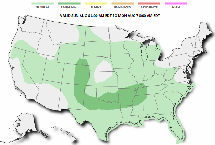
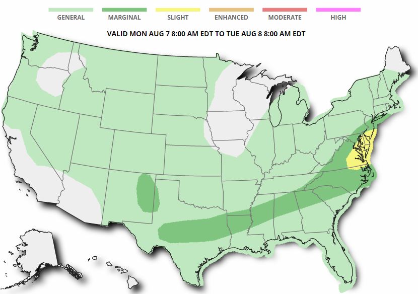
Severe Threats: Sunday & Monday
According to NOAA's SPC, there is a MARGINAL risk of severe storms across parts of the Front Range of the Rockies and across parts of the Southern US. On Monday, the threat stretches from the Southern US to the Eastern US, with the best potential of severe weather in eastern Virginia over to southern New Jersey.
Excessive Rainfall Potential Sunday & Monday
According to NOAA's WPC, there is a risk of excessive rain on Sunday and Monday across parts of the Front Range of the Rockies, the Central US and across parts of the Southern US. Note that the best potential for excessive rainfall and flooding will be found in the yellow areas below.
.gif)
.gif)
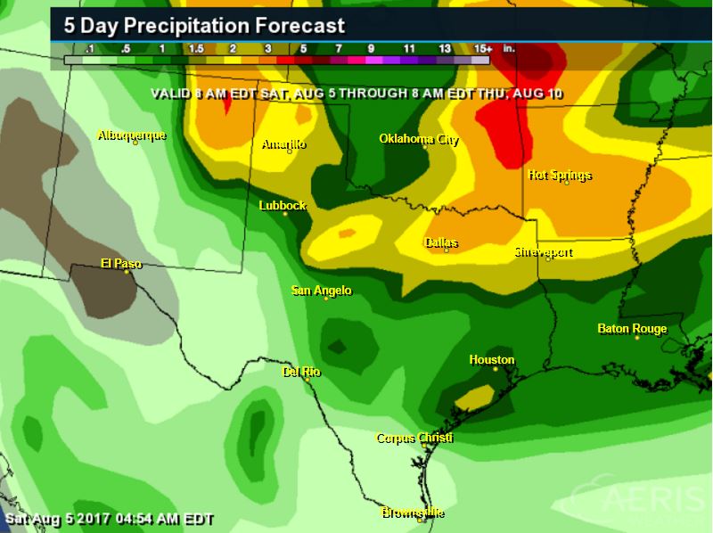
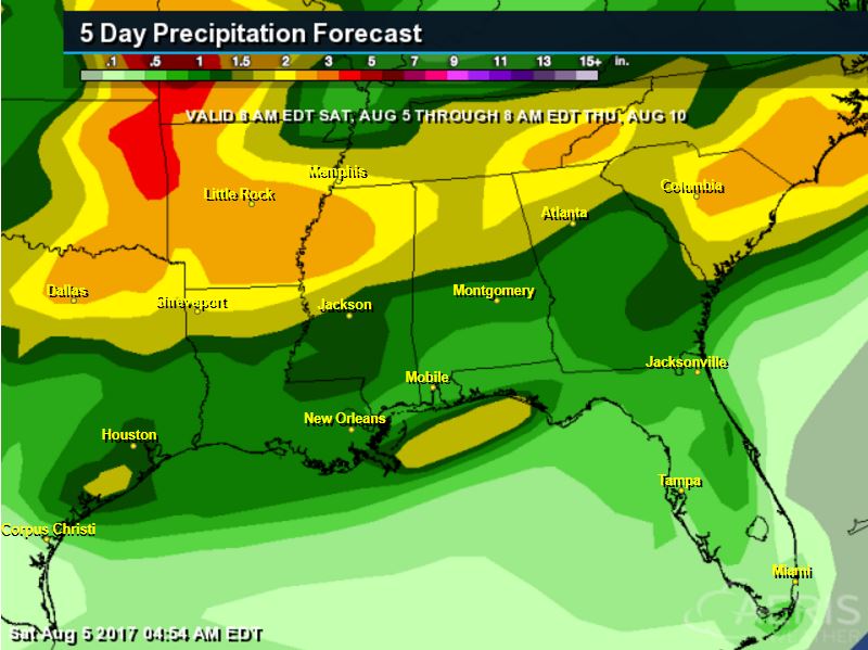
Localized Heavy Rain Threats
Excessive rainfall will be possible across the southern half of the country from the Front Range of the Rockies to the Eastern US. Note that there could be some 3" to 5"+ rainfall tallies through the middle/end of the week.
________________________________________________________
Monsoon Storms Continue
Here's the simulated radar from Sunday to Thursday, which shows the potential of daily monsoon storms continuing across parts of the Southwest region. Note that some of the storms could be a little on the strong side with gusty winds, dust storms and locally heavy rain, which could lead to localized flooding. The rainfall forecast below suggests that some areas could see up to 1" of rain or more through the end of the week!
.gif)
________________________________________________________________________
"Death Valley just experienced the hottest month ever recorded in the U.S."
"The average temperature in Death Valley last month was a stifling, suffocating 107.4 degrees. It was the hottest month ever recorded in the United States, and the second-hottest in the world — by just a fraction of a degree. The average monthly temperature is a combination of highs and lows. Daytime temperatures in Death Valley are known to be excruciatingly hot. In fact, it is currently the location of the hottest temperature ever recorded on Earth, 134 degrees. (Note: This record is currently being challenged.) But perhaps more alarming in this record is the month’s overnight temperatures — when things are supposed to cool down. The temperature didn’t fall below 89 degrees at any point in the month of July at Death Valley. On three nights, the “low” temperature was 102-103 degrees."
(David McNew/Getty Images via WashingtonPost)
 ___________________________________________________________
"As the Northwest Boils, an Aversion to Air-Conditioners Wilts"
"Before the first batch of Nutella and sea salt doughnuts was sold on Fremont Street on Wednesday morning, Brianna Gneckow posed a question to her co-workers at Pip’s Original Doughnuts: “Does everybody have water?” But by lunch, hours before Portland endured a daily record high of 103 degrees, the staff had switched off the fryer and locked the doors. Portland, of all places, was just too hot. As the Pacific Northwest sweated and wilted this week in the grip of one of the fiercest heat waves ever recorded in this region, Portland reached 105 degrees on Thursday but again fell short of the all-time mark of 107. A 78-year-old record in Salem, the Oregon capital, fell on Wednesday, when the city hit 106 degrees. Thermometers in Seattle, a three-hour drive from Portland, showed temperatures in the 90s on Wednesday and Thursday, setting daily records."
(People cooling off at a park in Beaverton, Ore., on Tuesday. The Pacific Northwest has been in the grip of one of the fiercest heat waves ever recorded in the region. CreditStephanie Yao Long/The Oregonian, via Associated Press)
 ___________________________________________________________
"Roasting and Gasping in Pac NW; All-Time Record Heat in Southeast Europe"
"During the first three days of August, some locations in the Pacific Northwest have approached their hottest temperatures ever recorded—and parts of southeast Europe have seen all-time highs. More brutally hot days lie ahead, as residents endure a multi-day heat wave that ranks among the worst on record for both regions (even as the central and eastern U.S. enjoys an unusually mild first week of August). Western Oregon has been the epicenter of this week’s exceptional Northwest heat. On Thursday, Portland, OR, soared to 105°F. Only five days in Portland’s history have been hotter, most recently 106°F on July 28 and 29, 2009. Medford hit 112°F on Wednesday, a temperature last seen in August 1981 and not far from Medford’s all-time high of 115°F. “Last time we saw heat like this, postage stamps were 20 cents,” noted the NWS office in Medford. The state capitol of Salem came just a degree short of its all-time high on Wednesday, hitting 107°F. Plenty of daily record highs also fell by the wayside from central California to western Washington, though the heat wasn’t quite so impressive on either side of Oregon. Seattle hit 94°F on Thursday, breaking the daily record of 91°F set in 1939. The pace of record-setting will gradually lessen over the next several days, as low-level flow near the Pacific Coast takes on more of an onshore component. On the down side, mid-level moisture will increase, which sets the stage for an increase in “dry” thunderstorms that could trigger wildfires. The fire weather outlook issued Thursday afternoon by the NOAA/NWS Storm Prediction Center highlights a dry-thunderstorm risk across most of the Pacific Northwest from Saturday through Wednesday."
 __________________________________________________________
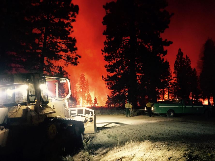
Modoc July Complex - Northern California
The Modoc July Complex in northern California is another large wildfire in the Western US that has ballooned to 83,000 acres. This particular fire started on Monday, July 24th by lightning! There are nearly 2,500 people working on the fire that is only 43% contained. The estimated containment date is expected to be on Wednesday, August 16th.
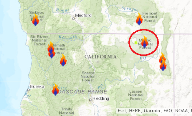
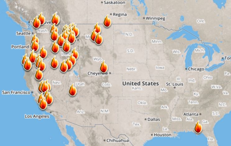
Ongoing Large Wildfires
Here's a look at the current wildfire map across the country. Recent hot and dry weather has helped to spark several wildfires across the Western US, while a few have also been popping up in the Eastern US.
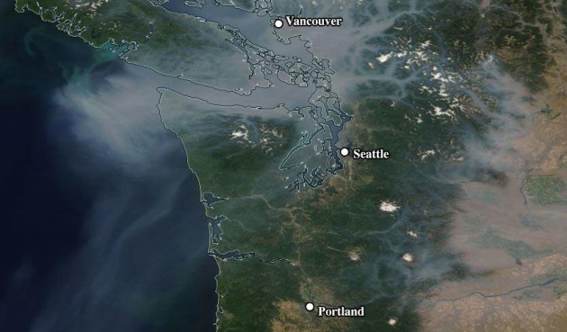
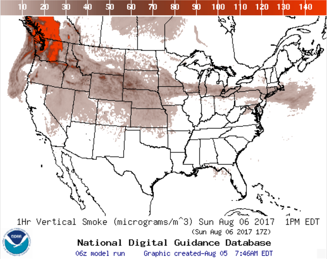
National Smoke Analysis
Here's the projected wildfire smoke concentration for midday Sunday, which suggests that smoke from wildfires burning across parts of Canada and the Western US could continue to linger around the High Plains and Upper Midwest. There also appears a very high concentration of smoke from fires burning across the western half of Canada. If you are in these areas, air quality could be a little poor, but these areas may also be enjoying very interesting looking sunrises/sunsets, which tend to look hazy or reddish-orange.
________________________________________________________________________
We Can All Agree On This: the Weather is Just Fine
By Paul Douglas
By Paul Douglas
The climate is changing. It's us. There are solutions. If you dwell on gloom & doom many people shut down.
WCCO Radio's Jordana Green and I have made a conscious choice not to focus on political intrigue. Report the news of the day, but not partake in the ongoing food-fight. Getting anyone to actually change their mind is the rough equivalent of asking a Vikings fan to root for the Packers. Good luck with that.
We'll focus on what unites us: common ground - solutions we can all agree on. Clean energy is one such bridge issue. Saving money. More good-paying jobs. Less pollution, cleaner water and a stable climate? Yes please.
Saturday's buttermilk sky was the result of smoke from western wildfires. A pop-up shower is possible by afternoon; more numerous showers Wednesday into next weekend as a cold low pressure swirl temporarily stalls nearby. Expect 70s for highs this week, but models show a slow warming trend by mid-August. We'll probably see more 80s and a few more 90s later in August.
Is it too cool for the lake? Maybe, but I'll take a lukewarm-front any day of the week.
________________________________________________________________________
________________________________________________________________________
Extended Forecast
SUNDAY: AM sun, PM shower risk. Winds: NE 5-10. High: 77
SUNDAY NIGHT: Showers end early, then turning partly cloudy. Winds: NE 5. Low: 59
MONDAY: More sun, probably puddle-free. Winds: N 3-8. High: 79
TUESDAY: Plenty of sunshine, balmy. Winds: SW 5-10. Wake-up: 61. High: 81.
WEDNESDAY: Warm sun, few t-showers late? Winds: 5-10. Wake-up: 62. High: 82
THURSDAY: Better chance of showers and thunder. Winds: S 5-10. Wake-up: 63. High: 79
FRIDAY: Cloud-cluttered, more showery rains.Winds: SE 7-12. Wake-up: 64. High: 75.
SATURDAY: Unsettled. Another shower or two. Winds: NW 7-12. Wake-up: 60. High: 74.
_______________________________________________________
_______________________________________________________
This Day in Weather History
August 6th
August 6th
1969: Tornadoes sweep across northern Minnesota, hitting Ely, Backus, Outing and Dark Lake. Damage could still be seen 20 years later in the BWCA.
1866: Torrential rain dumps 10.30 inches at Sibley in 24 hours. Widespread flooding occurs, washing out bridges and drowning many people. In Fillmore County it is known as the 'Wisel Flood' because 3 members of the Wisel family perished in the flood.
________________________________________________________
________________________________________________________
Average High/Low for Minneapolis
August 6th
August 6th
Average High: 82F (Record: 99F set in 2001)
Average Low: 63F (Record: 48F set in 1977)
Average Low: 63F (Record: 48F set in 1977)
Record Rainfall: 1.67" set in 1995
_________________________________________________________
_________________________________________________________
Sunrise/Sunset Times for Minneapolis
August 6th
August 6th
Sunrise: 6:04am
Sunset: 8:32pm
Sunset: 8:32pm
Hours of Daylight: 14hours & 28mins
Daylight LOST since yesterday: ~2 minutes and 33 seconds
Daylight LOST since summer solstice (June 20th): ~1 hour & 9 minutes
__________________________________________________________
Daylight LOST since summer solstice (June 20th): ~1 hour & 9 minutes
__________________________________________________________
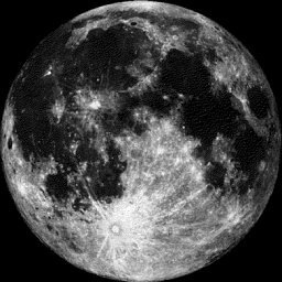
Moon Phase for August 6th at Midnight
0.5 Days Until Full "Sturgeon Moon
0.5 Days Until Full "Sturgeon Moon
"Aug. 7, 2:11 p.m. EDT – Full Sturgeon Moon. This is when this large fish of the Great Lakes and other major bodies of water like Lake Champlain is most readily caught. A few tribes knew it as the Full Red Moon — because when the moon rises, it looks reddish through sultry haze — or the Green Corn Moon or Grain Moon.The moon will also undergo a partial lunar eclipse. About one-quarter of the moon's lower limb will be immersed in the Earth's dark umbral shadow at 18:20 universal time. This eclipse favors the Eastern Hemisphere; much of the Western Hemisphere will be shut out of seeing this eclipse since it will occur during the daylight hours when the moon is below the horizon."
_________________________
Weather Outlook For Sunday
High temperatures on Sunday will once again be a little below average with readings in the 70s across the state. However, dewpoints will be quite comfortable with readings in the 50s. No sweat...
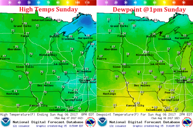
Weather Outlook For Sunday
Winds on Sunday will be fairly light and out of the northeast, which will help to keep dewpoints in the comfortable range.
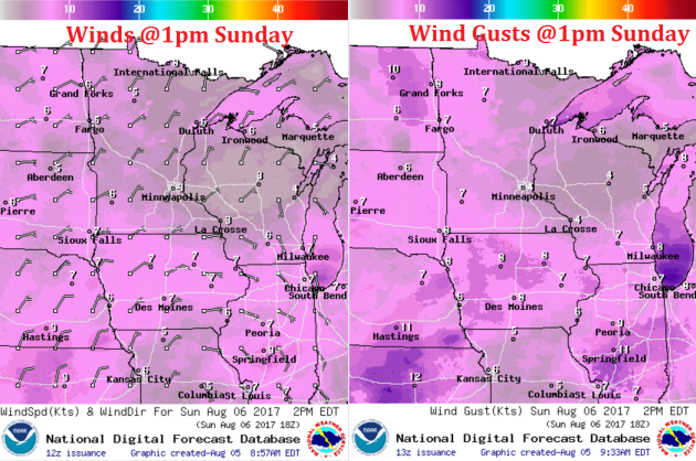
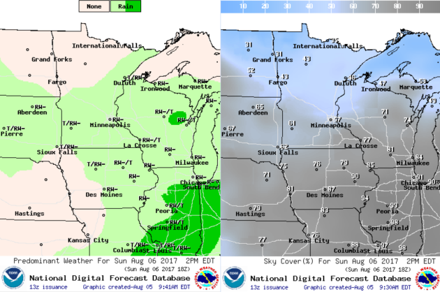
It'll be another somewhat unsettled day Sunday with bubble up showers and isolated rumbles of thunder developing during the afternoon/early evening hours. There may be a few heavy downpours, but the threat for widespread heavy rainfall is minimal.
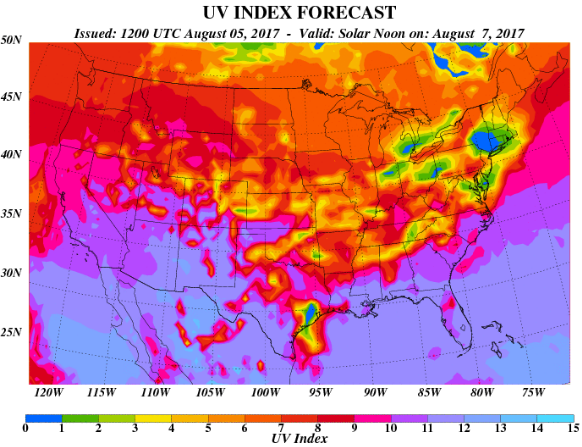
The UV Index for Sunday will be HIGH, which means that it will only 20 to 30 minutes or less to burn unprotected skin. With that said, if you are planning on spending any extended length of time outside, make sure you wear appropriate attire and lather on the sun block!
 __________________________________________________________________________
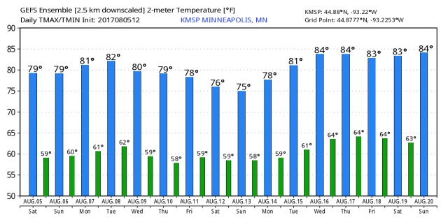
Minneapolis Temperature Outlook
Here's the temperature outlook through August 20th, which shows temperatures hovering around 80F through the rest of the week. However, there appears to be a bit of a cool down by the 2nd weekend of August before readings jump back into the mid 80s for the 2nd half of the month.
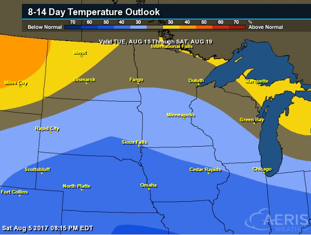
8 to 14 Day Temperature Outlook
According to NOAA's CPC, the extended temperature outlook from August 15th to August 19th suggests cooler than average temperatures lingering across much of the Midwest, but we're starting to get indications of a warm-up by the 2nd half of the month.
___________________________________________________________
Extended Temperature Outlook
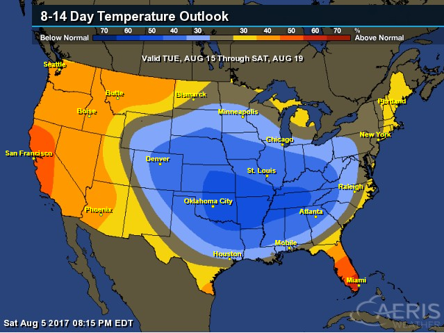
According to NOAA's CPC, the extended temperature outlook through August 19th shows that a large chunk of the Central US will still be dealing with cooler than normal temperatures, while the western part of the country will be above average.
Extended Temperature Outlook
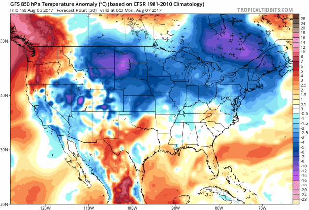
Here's the extended 850mb temperature anomaly loop into early next. This describes how warm or cold (from average) mid/low level temperatures will be over time. Note that the cooler blues look to linger across much of the Central and Eastern US over the next several days, while the warmer reds/oranges continue across the Western third of the nation.
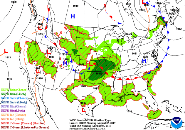
Weather Outlook Ahead
The weather outlook over the next couple of days shows stormy weather continuing across the Central and Eastern part of the county with areas of isolated strong to severe storms and locally heavy rainfall, which could lead to areas of flooding.
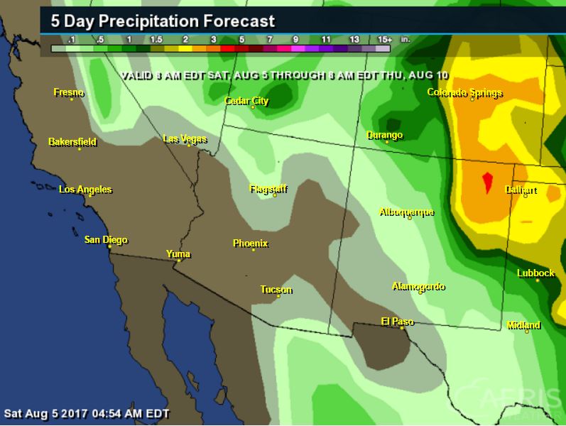
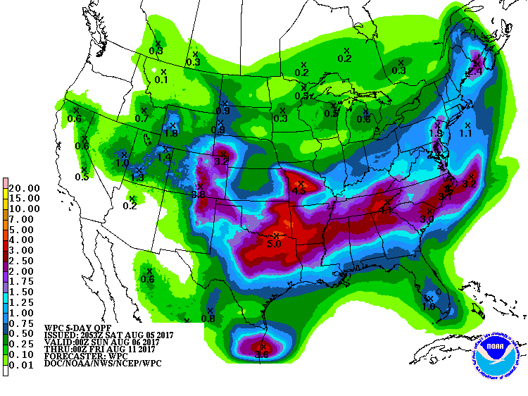
5 Day Precipitation Outlook
According to NOAA's WPC, the next several days could produce areas of locally heavy rainfall across many areas from the Desert Southwest to the Midwest and eastern half of the country. Some of the heaviest rainfall could add up to as much as 3" to 5"+, which could also lead to areas of localized flooding.
 ___________________________________________________________________
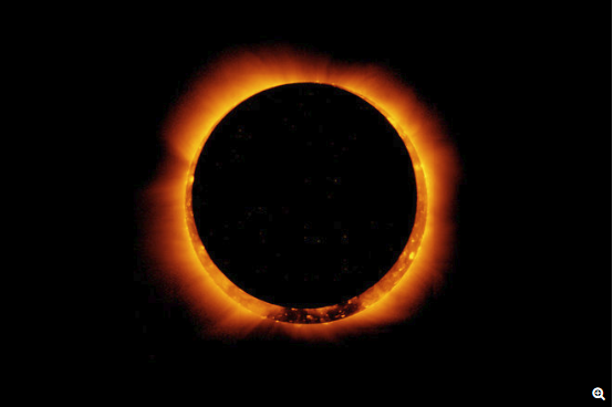
"Eclipse Overload: What If the Sun Were Blocked for Years?"
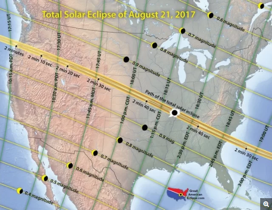
"Total solar eclipses are astonishing events to witness, and preparations for them — particularly for eclipses with paths that are visible to large numbers of people, such as the Aug. 21 eclipse — can generate widespread "eclipse fever" that lasts for months. However, the eclipse itself speeds by all too quickly, with the total eclipse visible for about 2 minutes. The length of totality for the upcoming Great American Solar Eclipse will vary across locations; Earth's rotational speed and the curvature of its surface — together with the orbital speed of the Earth and moon — determine how long a total eclipse is visible at any given point, Space.com reported. People in Carbondale, Illinois, will enjoy the longest period of total darkness during the eclipse, beginning at 1:20 p.m. local time and lasting 2 minutes and 40 seconds, according to NASA. The fleeting nature of eclipses is a good thing. While the moon doesn't block the sun's light for long, other events in Earth's past did significantly obstruct the sun for weeks, months or even years at a time, which can have devastating consequences for life on the planet."
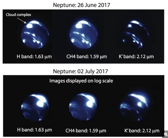
"Surprise! New Neptune Storm Appears in a Bizarre Location"
"A nearly Earth-size storm system was spotted near Neptune's equator, surprising scientists because no bright clouds have ever been seen in that location. The storm is about 6,000 miles (9,000 kilometers) in length — about three-quarters Earth's diameter — and is even huge compared to the size of Neptune: it spans nearly 30 degrees in both longitude and latitude. When astronomers studied the storm between June 26 and July 2, it appeared to get brighter. "Seeing a storm this bright at such a low latitude is extremely surprising," Ned Molter, a graduate student at the University of California, Berkeley, said in a statement. He saw the storm while doing a test run at the W. M. Keck Observatory at Mauna Kea, Hawaii."
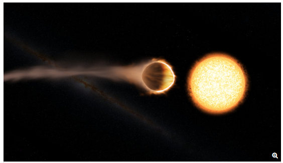
"Hubble Telescope Detects Stratosphere on Huge Alien Planet"
"A huge, superhot alien planet has a stratrosphere, like Earth does, a new study suggests. "This result is exciting because it shows that a common trait of most of the atmospheres in our solar system — a warm stratosphere — also can be found in exoplanet atmospheres," study co-author Mark Marley, of NASA's Ames Research Center in California's Silicon Valley, said in a statement. "We can now compare processes in exoplanet atmospheres with the same processes that happen under different sets of conditions in our own solar system," Marley added."
(Credit: Engine House VFX, At-Bristol Science Centre, University of Exeter)
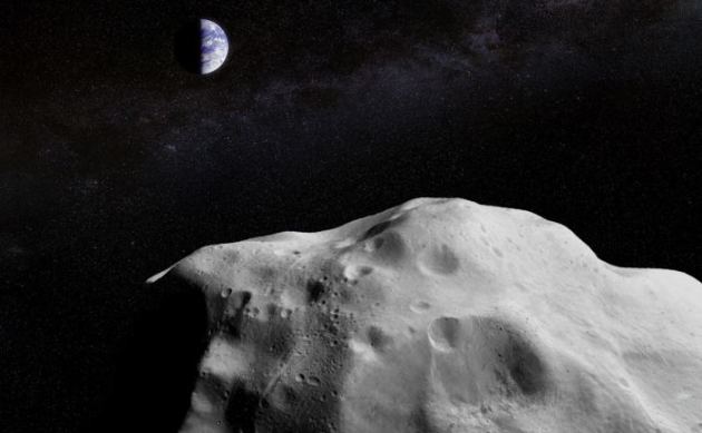
"IMPENDING ASTEROID FLYBY WILL BE A CHANCE TO TEST NASA’S PLANETARY DEFENSE NETWORK!"
"This coming October, an asteroid will fly by Earth. Known as 2012 TC4, this small rock is believed to measure between 10 and 30 meters (30 and 100 feet) in size. As with most asteroids, this one is expected to sail safely past Earth without incident. This will take place on October 12th, when the asteroid will pass us at a closest estimated distance of 6,800 kilometers (4,200 miles) from Earth’s surface. That’s certainly good news. But beyond the fact that it does not pose a threat to Earth, NASA is also planning on using the occasion to test their new detection and tracking network. As part of their Planetary Defense Coordination Office (PDCO), this network is responsible for detecting and tracking asteroids that periodically pass close to Earth, which are known as Potentially Hazardous Objects (PHOs) In addition to relying on data provided by NASA’s Near-Earth Object (NEO) Observations Program. the PDCO also coordinates NEO observations conducted by National Science Foundation (NSF)-sponsored ground-based observatories, as well as space situational awareness facilities run by the US Air Force. Aside from finding and tracking PHOs, the PDCO is also responsible for coming up with ways of deflecting and redirecting them."
(Artist's concept of a large asteroid passing by the Earth-Moon system. Credit: A combination of ESO/NASA images courtesy of Jason Major/Lights in the Dark.)
 ________________________________________________________________
"Fake Solar Eclipse Glasses Are Flooding the Market: How to Stay Safe"
"If you're planning to view the total solar eclipse on Aug. 21, make sure you've got the right safety gear. Phony eclipse glasses are currently flooding the marketplace, according to the American Astronomical Society (AAS). This counterfeit equipment falsely claims to meet the international standard for safe solar viewing, which is known as ISO 12312-2 (also written as ISO 12312-2:2015). So how do you know that your eclipse glasses or handheld viewers are safe? You can't really check them yourself; doing so requires pretty high-tech lab equipment. But the AAS has done such legwork for you and identified a number of reputable suppliers, including (but not limited to) American Paper Optics, Rainbow Symphony, Celestron and Daystar. You can also trust the businesses and other organizations that sell gear made by these companies, AAS representatives said. (There are many such retailers, including Wal-Mart, Lowes and Toys R Us.)"
(The total solar eclipse of Aug. 21, 2017, will cross the contiguous United States. Totality will be visible only for observers within the 70-mile-wide (113 kilometers) path shown, peaking at 2 minutes and 42 seconds near Carbondale, Illinois. Credit: Great American Eclipse)
Thanks for checking in and don't forget to follow me on Twitter @TNelsonWX

No comments:
Post a Comment