"Cool", Dry Weather Expected For The Middle Of The Month
Have
you enjoyed the cooler weather recently across the state? Well, it
looks like it could stick around toward the middle of the month, which
means highs will continue to be in the 70s to low 80s. Those highs would
be around to slightly below average for this time of year. The Climate
Prediction Center shows the potential of below average temperatures
across the southern two-thirds of the state for the August 13-19 time
frame. Meanwhile, parts of far northern Minnesota could see above
average temperatures.
Meanwhile,
after we get through some rain later this week (more on that in a
moment) it looks like we could be going into a dry stretch. The CPC 8-14
day precipitation outlook shows below average precipitation is expected
across the state between August 13-19.
_______________________________________________
Weather Anxiety: Why Does the Forecast Change?
By Paul Douglas
It
looks like meteorological bait-and-switch. On a Wednesday you check the
paper or web site (or favorite app) and the weekend forecast looks
great. Look at all those sun symbols! Cue Jimmy Buffet tunes in your
head. But by Friday those smiling sun symbols mutate into ominous
raindrops and lightning bolts. Say what?
Here's the deal: the
forecast changes as new data comes in. Observations from satellites,
weather balloons and airports fuel weather models that allow us to look
out a week. Junk-in, junk-out. The closer you get to the event the more
reliable the data that fuels the models we look at.
Global ECMWF
(European) and GFS models run twice a day; NOAA's NAM model updates 4
times daily - and we make changes to the 7-Day.
We dry out today
but models bring more T-showers into Minnesota Wednesday into Sunday. It
won't be a continuous rain, but unusually chilly air aloft keeps the
atmosphere in a showery mood later this week. Enjoy a run of comfortable
70s because I see more 80s and a few steamy 90s returning later this
month. Do NOT write off the summer of '17 just yet.
_______________________________________________
Extended Twin Cities Forecast
MONDAY: Lukewarm sun, perfect. High 80. Low 60. Chance of precipitation 10%. Wind N 3-8 mph.
TUESDAY: Blue sky, as good as it gets. High 81. Low 62. Chance of precipitation 10%. Wind SW 7-12 mph.
WEDNESDAY: Sunny start, late PM T-storm. High 80. Low 63. Chance of precipitation 40%. Wind S 7-12 mph.
THURSDAY: Humid, more showers & T-storms. High 76. Low 62. Chance of precipitation 60%. Wind S 5-10 mph.
FRIDAY: Sunny breaks. Drying out a bit. High 78. Low 61. Chance of precipitation 10%. Wind NE 7-12 mph.
SATURDAY: AM sun, few PM storms possible. High 76. Low 60. Chance of precipitation 50%. Wind E 7-12 mph.
SUNDAY: Have a Plan B. Showers in the area. High 72. Low 61. Chance of precipitation 60%. Wind E 10-15 mph.
_______________________________________________
This Day in Weather History
August 7th
1968: 7.09 inches of rain falls at Mankato. 1,200 homes are damaged. Highways 169 and 22 are blocked by mudslides.
1955:
The climate record of George W. Richards of Maple Plain ends. He
recorded weather data with lively notations on phenology and weather
events. He began taking observations when he was eleven in 1883. He
continued to take observations for 72 years, with 66 years as a National
Weather Service Cooperator.
1896: The final day of a massive heat wave brings highs of 104 to Le Sueur and Mazeppa.
1863:
A Forest City observer sees what he calls a 'perfect tornado.' He noted
that it 'drove principally from west to east and lasted about one half
hour.'
_______________________________________________
Average Temperatures & Precipitation for MinneapolisAugust 7th
Average High: 82F (Record: 98F set in 2001)
Average Low: 63F (Record: 45F set in 1972)
Average Precipitation: 0.15" (Record: 2.29" set in 1984)
________________________________________________
Sunrise/Sunset Times for MinneapolisAugust 7th
Sunrise: 6:05 AM
Sunset: 8:31 PM
*Length Of Day: 14 hours, 25 minutes and 12 seconds
*Daylight Lost Since Yesterday: ~2 minute and 35 seconds*Next Sunrise At/After 6:30 PM: August 28th (6:30 AM)*Next Sunset At/Before 8:30 PM: August 8th (8:29 PM)
_______________________________________________
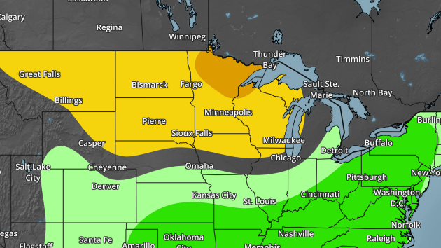
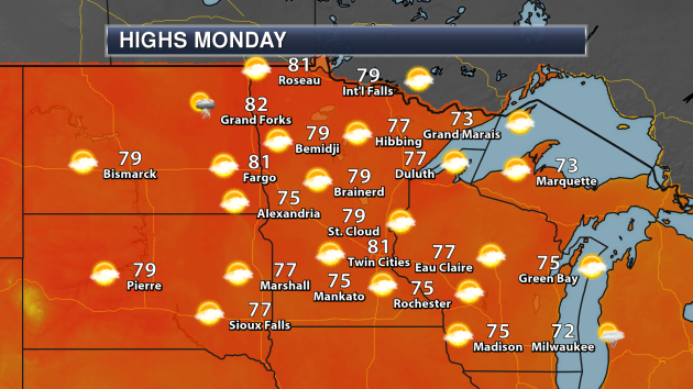
Minnesota Weather Outlook
No
weather concerns are expected across the state Monday, with highs in
the 70s to low 80s and mainly sunny skies. Certainly weather you can't
complain about in early August!
The
highs expected Monday are still expected to be slightly below average
across parts of southern Minnesota, with temperatures closer to average
across northern Minnesota.
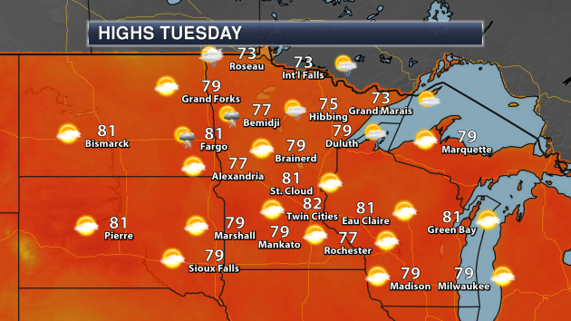
Across
southern Minnesota, Tuesday could be the warmest day of the next seven,
with highs in the upper 70s to low 80s. If you are heading down to
Mankato for the last day of Vikings Training Camp, temperatures will be
around 80 with mainly sunny skies. A few showers and storms will be
possible across northern Minnesota, with slightly cooler temperatures.
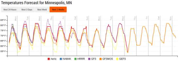
Taking
a look at the temperature trend, highs will remain in the 70s and 80s
through the middle of the month in the Twin Cities. There does appear to
be a slight warming trend as we head toward the week of the 14th, with
highs rising slightly above average.
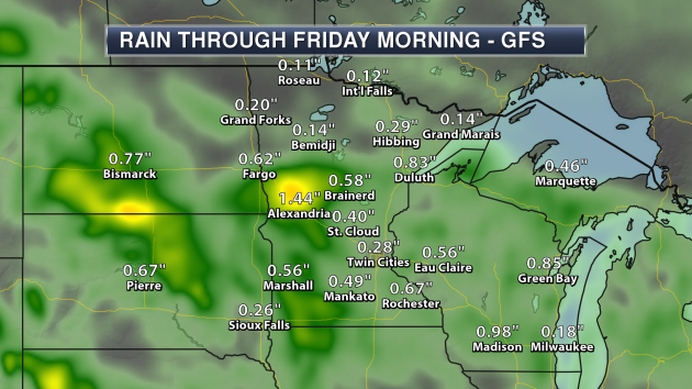
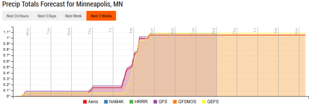
Toward
the middle to end of the week, the weather looks to become unsettled
across the region, with the potential of at least a quarter to a half an
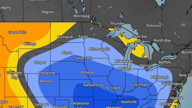
inch of rain across southern and central Minnesota.
That
unsettled weather looks to continue into at least the first half of the
weekend. Through next Sunday, the Twin Cities could pick up an inch or
more of rain. After that, long range models show drier weather for next
week.
_______________________________________________
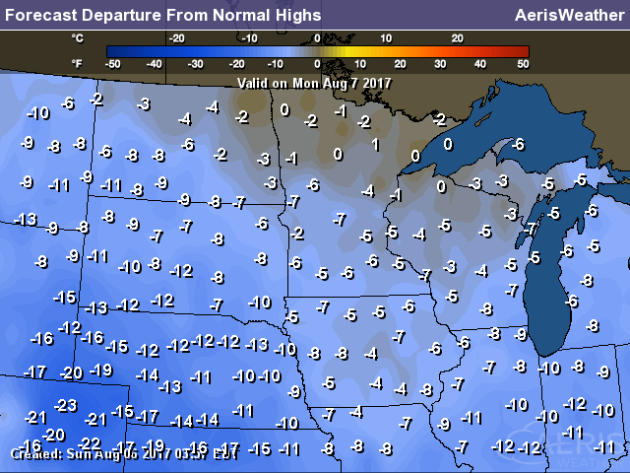
National Weather Outlook
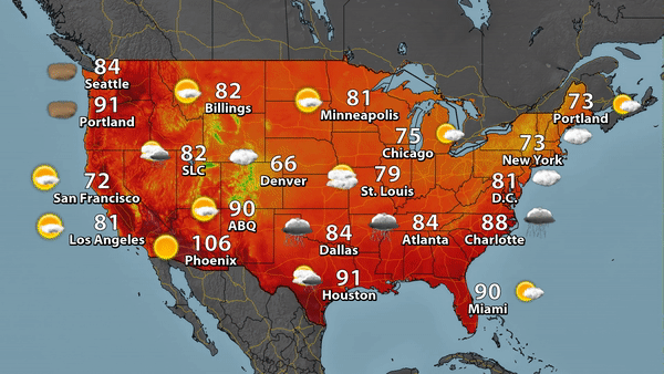
Monday’s Forecast
On
Monday, a frontal boundary will bring rain, heavy at times, across
parts of the Southern and Southeastern United States. Meanwhile, an area
of low pressure will swing across the Ohio Valley and into the
Northeast, bringing some showers and storms along with it. High pressure
will start to settle in to the upper Midwest, with mainly sunny skies
and pleasant conditions. It'll be a cooler than average day across a
good portion of the nation - Denver is only expected to reach a high of
66!
Temperatures
are expected to be cooler than average across most of the nation on
Monday, with the highest departures from average expected across parts
of the central and southern Plains and along the Front Range. In these
areas, highs will be 10-20 degrees below average.
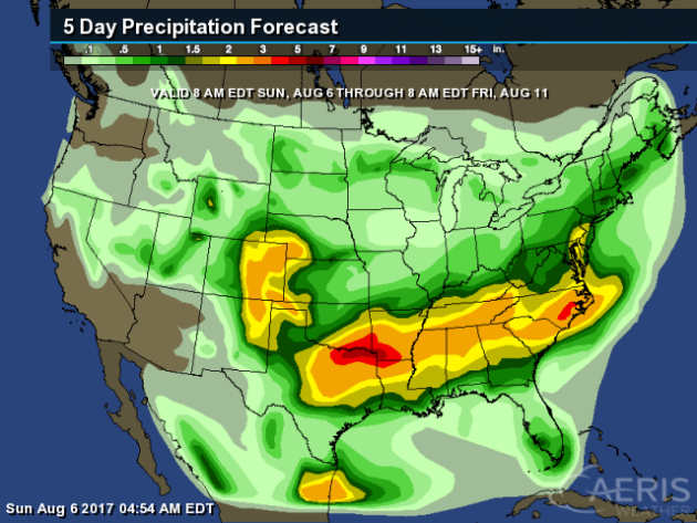
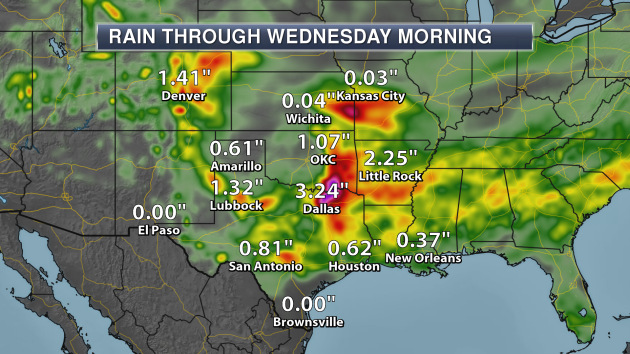
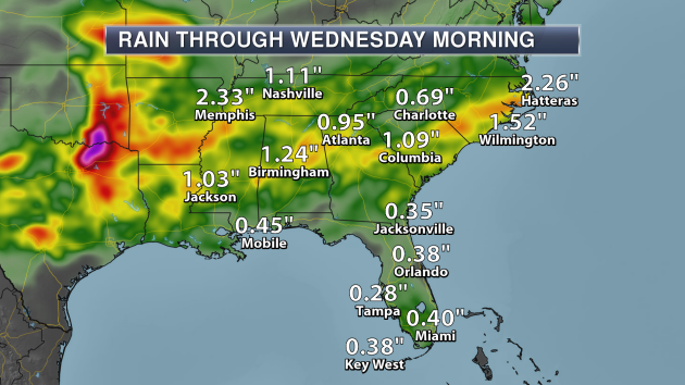
Heavy
rain is expected as we head through the middle of the week across parts
of the Southern Plains and Southeast, with the potential of 2"+ of rain
through the end of the week. The heaviest is expected along the Red
River of the South, with the potential of 3-5" of rain.
With
a front stalling across the south, waves of rain (heavy at times) is
expected through the middle of the week. Places have the potential of
receiving 2"+, especially near and along the Red River.
Through
Wednesday morning, parts of the Southeast could receive at least an
inch of rain. The lowest totals are currently expected along parts of
the Gulf Coast and across Florida.
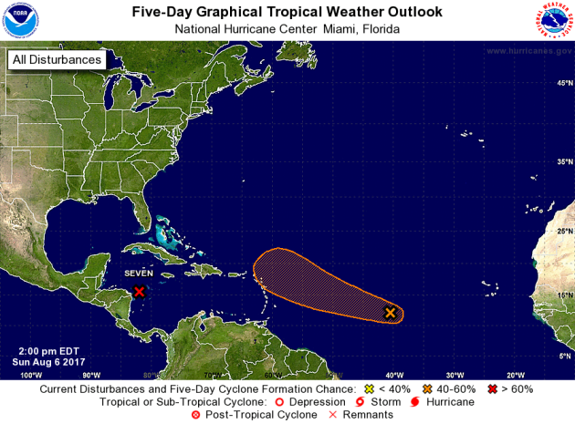
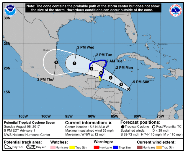
We're
also keeping a close eye on the Atlantic over the next several days.
There are two systems that could form into tropical cyclones. The first,
in the western Caribbean, has been declared Potential Tropical Cyclone
Seven, and is likely to become a tropical storm before moving over the
Yucatan Peninsula and into the Bay of Campeche. I have the expected path
in the image below for this system. The second, sitting between the
Cabo Verde Islands and Lesser Antilles has a 50% (medium) chance at
becoming a system as it continues off to the west northwest.
_______________________________________________
Many Rain Delays At SunTrust Park - Why?
Through
last Tuesday, there have been 11 rain delays at the new baseball
stadium in Atlanta. Why so many delays? Meteorologists at the University
of Georgia may have an answer.
More from Atlanta Magazine: "
The
short answer: On typical summer days, Atlanta can produce its own
storms, many of which follow a predictable pattern and path. SunTrust
Park happens to be in a part of the city that’s primed for extra
rainfall. The long answer: We’ll start with a concept called the urban
heat island effect. Because Atlanta is fit for retaining heat with its
large amounts of asphalt, concrete, and carbon emissions from cars, it’s
typically a hot bed in comparison to its cooler rural surroundings.
This provides one key element to fuel rainstorms: rising warm air
surrounded by cooler air. Storms usually form as the city’s surfaces
begin to cool and re-emit heat back into the atmosphere. This typically
happens in the evening—right around the time of, say, the opening pitch
of a baseball game. However, where these rainstorms travel once they
form depends on what the study calls the urban rainfall effect."
(Image: Mean daily precipitation in Atlanta and its metro areas during
meteorological summers, from 2002-2015. McLeod, J., et al.,
Spatio-temporal rainfall patterns around Atlanta, Georgia and possible
relations..., Urban Climate (2017))
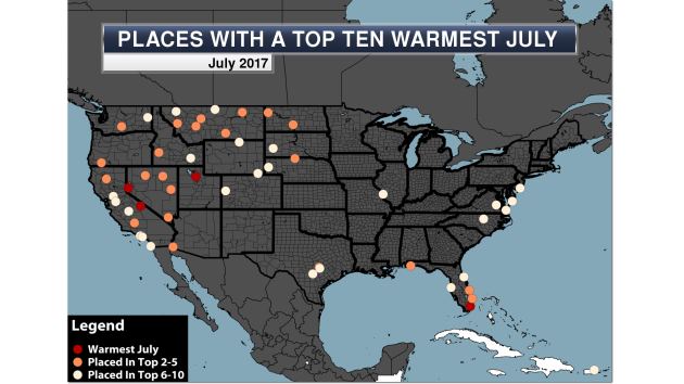
Another Wet, Warm Month Across The U.S. In July
While
the heat was predominately across the western U.S. during the month of
July, some places in the eastern lower 48 saw heavy rain.
More from Praedictix: "
The
heat during July 2017 was scattered across parts of the U.S., mainly
concentrated in the western portion of the nation and across Florida.
Four locations saw their warmest July on record, including in Miami, FL.
Miami sticks out greatly numerous heat records have been approached or
broken in the city so far this year, including the second longest
stretch of 90s on record (41 days ending July 30th). The overall average
monthly temperature of 85.7 beat the previous warmest month ever on
record by 0.4 degrees!"
DNA Sunscreen
Scientists
are now experimenting with DNA to help create a better sunscreen that
would do a better job at protecting skin from UV light than normal
sunscreen.
More from Scientific American: "
Many
sunscreens wear off over the course of a day, but a DNA material
developed by US scientists gets better at absorbing ultraviolet (UV)
light the longer it is exposed to it. The transparent coating could
protect skin – particularly damaged areas – from sunburn over long
periods of time." (Image:
thejaan Flickr)
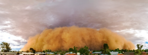
Global Warming and Monsoon Season
We
are seeing more intense rainfall during the monsoon season in the
Southwest, all due to global warming according to a new study.
More from Climate Central: "
Every
summer, rivers of moisture in the lower troposphere — the monsoonal
flow — stream into the Southwest from the Gulf of Mexico and Gulf of
California. Nearly every day in midsummer, the sun heats the mountains
and the deserts, creating convection. The rising warm air allows
thunderclouds to build during the day before exploding into dramatic
electrical storms in the afternoon and evening. But today’s monsoons
aren’t like the ones travelers on Route 66 would have driven through 60
years ago. " (Image: A haboob dust storm rolls over suburban Phoenix in 2012. Credit: Jasper Nance/flickr)
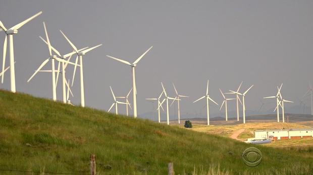
The Top Coal-Producing State Is Turning To Wind Energy
While
Wyoming is the top coal producing state in the nation, they are quickly
producing more wind energy - and embracing the change at the same time.
More from CBS News: "
Their
jobs involve dangling 300 feet in the air, roping the blade of a wind
turbine. The work comes with a view across the Wyoming prairie -- and a
view well into the future. Wind turbine jobs are expected to be the
fastest growing jobs in America between now and 2024, growing 108
percent. The turbines stand on reclaimed land covering a coal mine that
was worked for almost 50 years. But increasingly, Wyoming's energy
comes not from mining what's down below, but from mining the wind above." (Image: CBS News)
Super-Colossal Wind Turbines?
Ready for even bigger wind turbines? They may be coming soon.
More from NBC News: "
When
it comes to building things, Eric Loth has his head in the clouds. This
engineering professor at the University of Virginia wants to construct a
wind turbine standing more than five times higher than the Statue of
Liberty, with rotor blades longer than the Washington Monument is tall.
Not only that, the 1,650-foot-high mega-turbine would change along with
the weather, bending its blades gracefully to cope with
hurricane-strength winds. And all of this would happen dozens of miles
out at sea."
_______________________________________________
Thanks for checking in and have a great Monday! Don't forget to follow me on Twitter (@dkayserwx) and like me on Facebook (Meteorologist D.J. Kayser)!
- D.J. Kayser


No comments:
Post a Comment