76 F. maximum temperature in the Twin Cities yesterday.
75 F. average high on September 7.
77 F. high on September 7, 2016.
September 8, 1968: 1 3/4 inch hail falls in Goodhue County.
September 8, 1931: A record high is set in St. Cloud with a temperature of 102 degrees Fahrenheit.
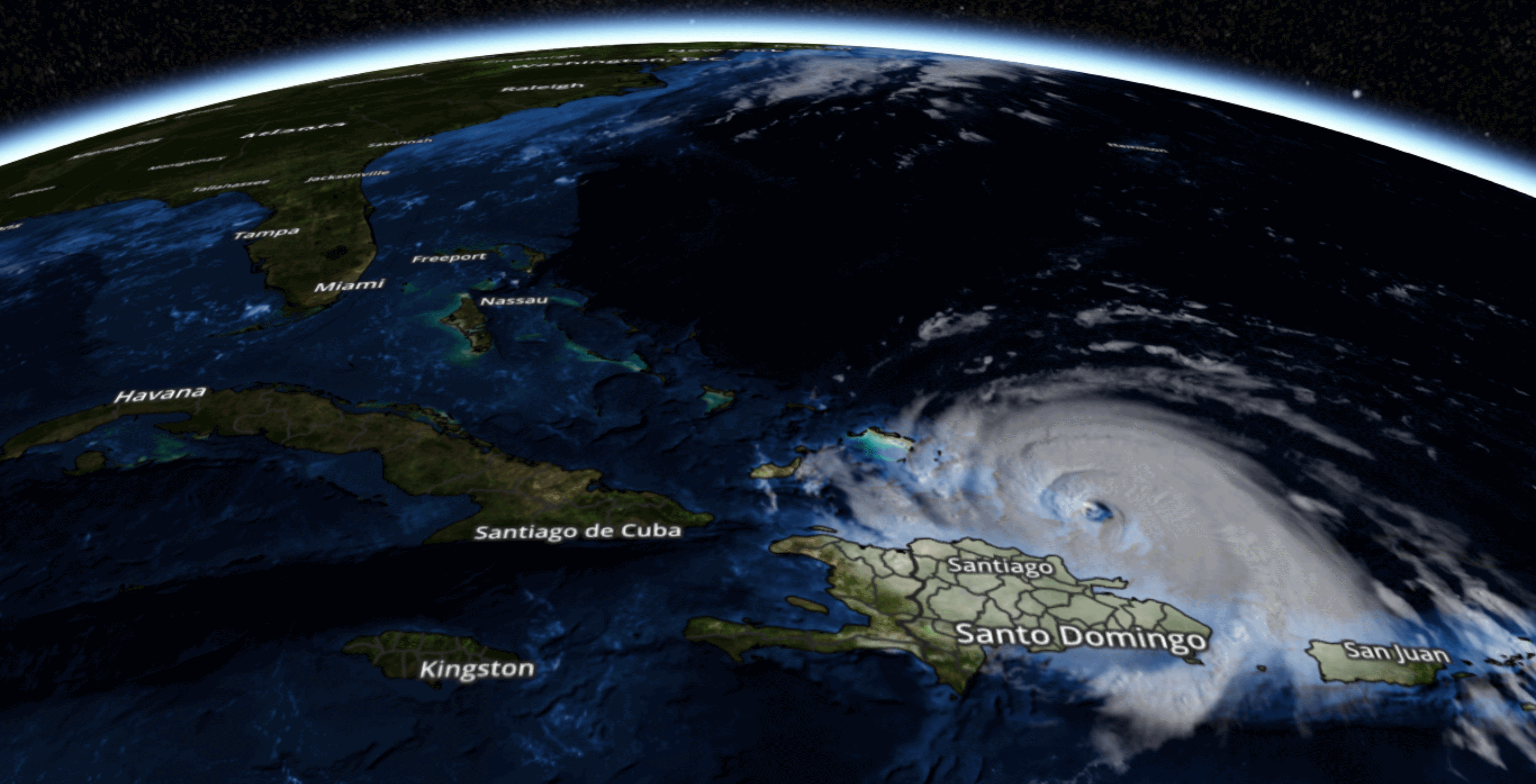
No Weather Here - Florida Braces for Super-Storm
"When men lack a sense of awe, there will be disaster" the Tao Te Ching explains.
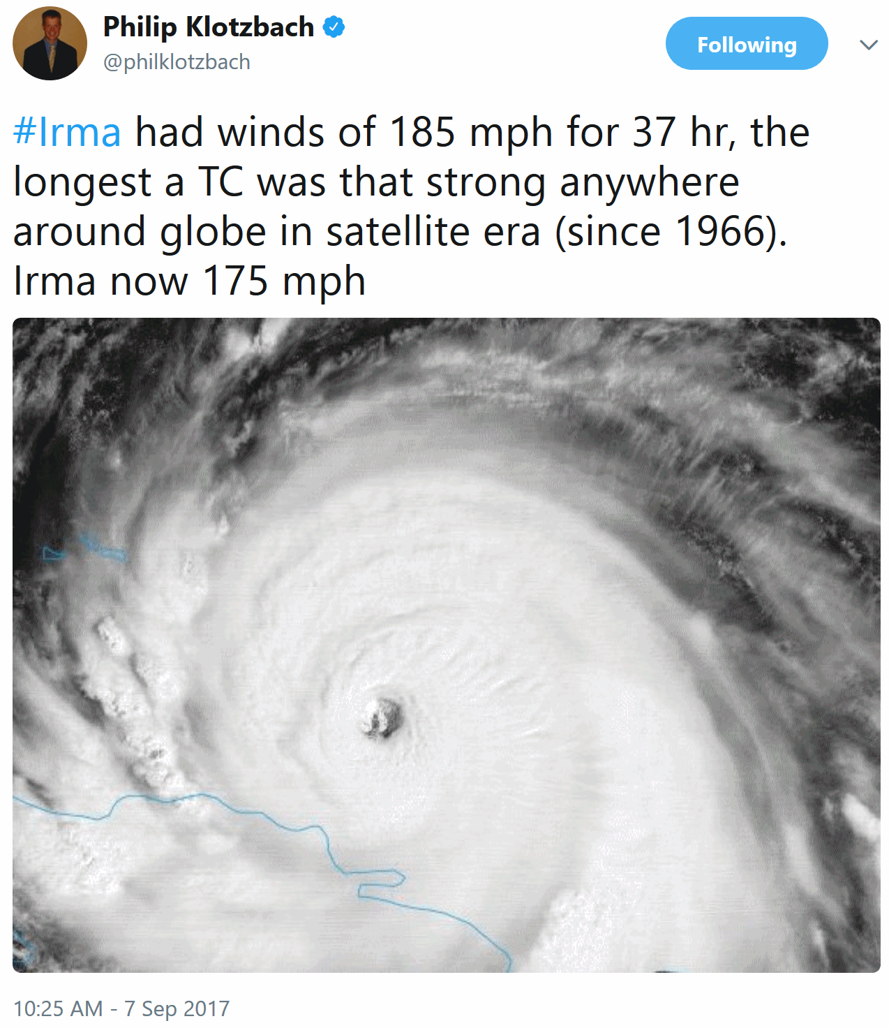
That verse is etched in my brain as I track Irma, a super-hurricane that defies description. Meteorologists have run out of superlatives. Irma had winds over 185 mph for 37 hours, making it the strongest tropical cyclone ever observed, anywhere on the planet, since the satellite record began in 1966.
People love to live by the water; perhaps it's in our DNA. We build homes on or near rivers and oceans, hoping technology (and government agencies) will ride to our rescue if something goes terribly bad.
South Florida is poised for a direct hit from Irma Sunday morning. People are evacuating, the Miami National Weather Service is using the same apocalyptic language I saw days before Harvey. It may be appropriate. This mega-storm may set the state of Florida back for many months to come.
Minnesota weather is an afterthought: dry and increasingly mild into next week, when highs flirt with 80F as a ridge of high pressure stalls over the Plains and Midwest into much of next week.
Our technology only goes so far - Mother Nature always bats last. Prayers for everyone in Florida.
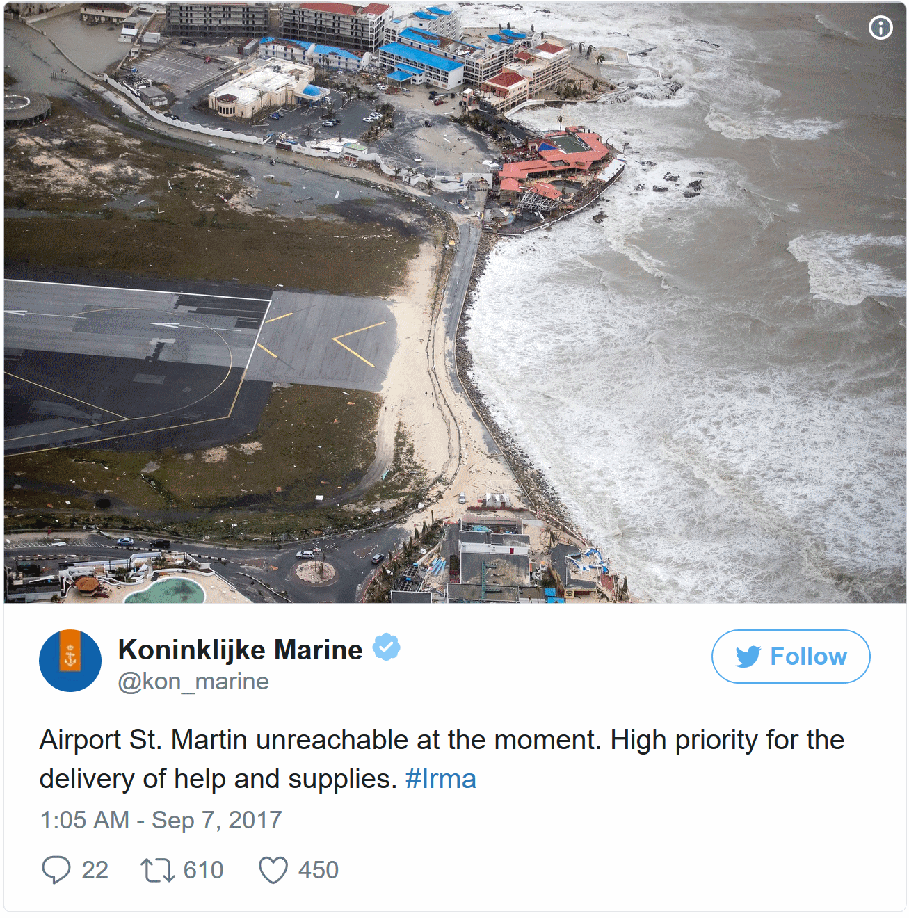
Hurricane Irma Leaves Devastation of "Epic Proportions" in Caribbean. NPR reports: "...I journeyed to Barbuda this afternoon and what I saw was heart-wrenching, absolutely devastating," Browne said on state-owned television Wednesday afternoon. "In fact, I believe that on a per capita basis, the extent of the destruction in Barbuda is unprecedented. And it is unprecedented, based on the type of storm. Hurricane Irma would have been easily the most powerful hurricane to have stormed through the Caribbean, and it is extremely unfortunate that Barbuda was right in its path." Browne told The Associated Press that nearly every building on the island has been damaged and that about 60 percent of the island's roughly 1,400 residents have been left homeless. He said at least one person, a child, had died..."
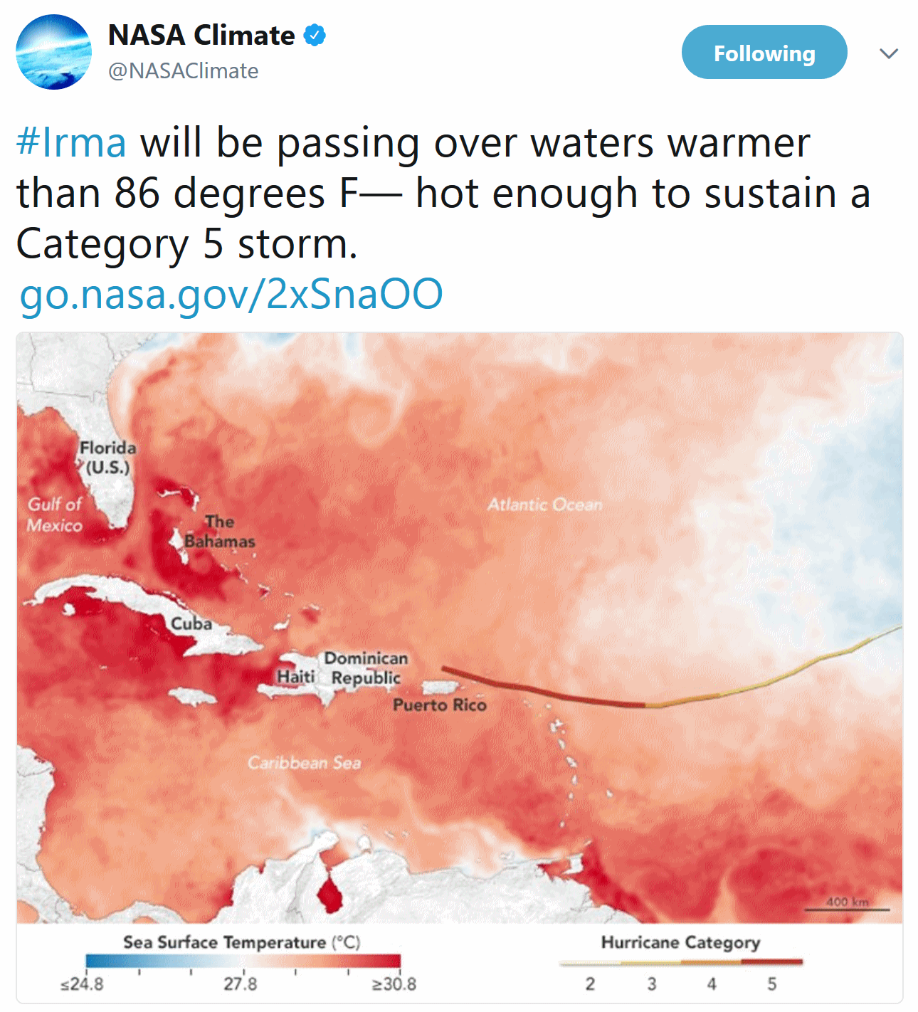
Hot Water Ahead for Hurricane Irma. No, I've never seen a NASA tweet quite like the one above. I think they wanted to get our attention: "On Sept. 6, 2017, Hurricane Irma slammed into the Leeward Islands on its way toward Puerto Rico, Cuba, and the U.S. mainland. As the Category 5 storm approaches the Bahamas and Florida, it will be passing over waters that are warmer than 86 degrees Fahrenheit (30 degrees Celsius)—hot enough to sustain a Category 5 storm. Warm oceans, along with low wind shear, are two key ingredients that fuel and sustain hurricanes. The map above shows sea surface temperatures in the Atlantic Ocean, Caribbean Sea and Gulf of Mexico on Sept. 5, 2017. The data were compiled by Coral Reef Watch, which blends observations from the Suomi NPP, MTSAT, Meteosat and GOES satellites and computer models. The mid-point of the color scale is 27.8°C, a threshold that scientists generally believe to be warm enough to fuel a hurricane. The yellow-to-red line on the map represents Irma’s track from Sept. 3–6..."

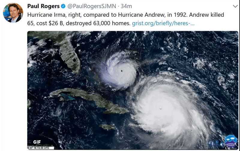
* I've been tracking weather for 45 years, and I've never seen anything like Irma. Not even close. We've had a few other Category 5 storms (Andrew comes to mind in 1992) but Irma is in a league of its own, in terms of size, ferocity and tenacity.
* Sustained winds are still 175 mph, and with the core of the storm over (unusually) warm Caribbean ocean water some additional strengthening is possible. It's looking more and more like Irma will maintain Category 5 strength into south Florida late Saturday night.
* Water temperatures in the Bahamas (where water is shallow and heats more rapidly) are over 86F, and this will be rocket-fuel for Irma as it approaches the United States. It's quite possible that sustained winds of 120-140 will impact the Miami area for several hours Sunday morning.
* Hurricane Warnings and Storm Surge Warnings are posted for south Florida and the Keys; a surge as high as 10 feet may result if Irma's eye passes over or just west of Miami (which computer models are suggesting) Sunday morning. This is problematic, since 85% of Miami Dade County is located under 10 feet mean sea level. The resulting flooding and wind damage may be unlike anything we've ever seen before in an American city. Harvey was very bad. Irma looks worse.
* High tide in Miami is around midnight Saturday night, which will magnify the storm surge a couple more feet. Keep in mind Miami now routinely floods on a clear day with no storm due to rising seas. The worst storm surge flooding will probably set up south of Miami, toward Homestead, which was hit so hard by Andrew in '92.
* It's important to remember that this will be a double-strike: south Florida will bear the full brunt of a Category 4-5 storm Saturday night and Sunday morning, but a second landfall is expected along the Georgia-South Carolina border Monday afternoon, possibly as a Category 3 storm. Coastal flooding may be severe from just north of Jacksonville to Savannah and Hilton Head Island.
* South Florida may see catastrophic damage from Irma, but coastal Georgia/South Carolina may see a devastating storm surge as well. As such I expect the economic toll from Irma to be significantly larger than Harvey, with impacts on financial, mortgage and insurance markets that will reverberate into 2018. I hope I'm wrong.


Summary: We keep waiting for a break, for the models to converge on a solution that keeps the worst of Irma out at sea (much like Matthew last year). There's still a small (and shrinking) chance of a last-minute reprieve, but we can't count on it. Looking at the statistics, odds now favor a severe to catastrophic blow to Florida, with Miami bearing the brunt of the storm. Damage will be lighter from Naples and Sarasota to Tampa, but depending on the final track of the eyewall significant structural damage is possible as far north as Orlando, with power outages and flash flooding into Atlanta and Charlotte before Irma finally fizzles.
Rush preparations to completion - finalize evacuation plans on Friday. On Saturday and Sunday I wouldn't want to be within 10-12 feet of sea level in south Florida. If you can't get your people out encourage a vertical evacuation, third or fourth floor or higher of a well-built hotel or office building. Avoid outer walls and windows. If winds really do exceed 100 mph in Miami flying debris from windows blown out of condos will make going outside for any length of time life-threatening.
More updates on Friday.
Paul Douglas, Senior Meteorologist, Praedictix
Why Hurricane Irma Could Hurt, A Lot. Much Lies in Harm's Way. No kidding. Here's an excerpt from The New York Times: "The last time a Category 5 hurricane ripped through Florida, it was so destructive that meteorologists retired its name forever. That storm, Hurricane Andrew, made landfall southwest of Miami in 1992, killing 65 people, destroying 63,000 homes and inflicting $265 billion in economic losses. But if a similar-sized hurricane were to strike Florida today in the same spot, it would be far more catastrophic - causing up to $100 billion in damage, according to a recent analysis by Swiss Re, the reinsurance firm. That's even after accounting for the fact that South Florida has strengthened its building codes since Andrew. The reason is simple: Central and South Florida have grown at a breathtaking pace since 1990, adding more than 6 million people..."
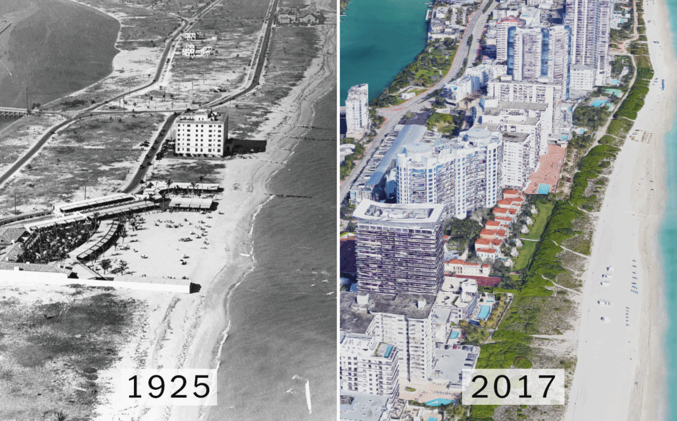
Photo credit: "Miami Beach a year before the Category 4 storm of 1926, and this year. The reinsurance firm Swiss Re estimates that a similar storm would inflict more than $200 billion in damage if it hit Miami today." Left, via State Archives of Florida; right, Google.
Preparing for an Extreme Hurricane. Irma is no garden-variety hurricane. The Guardian highlights the language being used by the Miami office of the National Weather Service: "The Miami station of the National Weather Station has issued a dire warning for the potential effects of the storm on southern Florida, in particular tornado-force winds and huge storm surges.
Florida residents should be prepared for the possibility that homes and buildings may be entirely “uninhabitable for weeks or months”, the station warned.
The main window of concern for hurricane Irma, impacts is early Saturday morning through Monday. Additional concerns exist for flooding rains, isolated tornadoes, significant beach erosion and surf, coastal flooding, and life-threatening rip currents.
Wind: prepare for life-threatening wind having possible devastating impacts across south Florida. Potential impacts include:
- Structural damage to sturdy buildings, some with complete roof adn wall failures. Complete destruction of mobile homes. Damage greatly accentuated by large airbone projectiles. Locations may be uninhabitable for weeks or months.
- Numerous large trees snapped or uprooted along with fences and roadway signs blown over.
- Many roads impassable from large debris, and more within urban or heavily wooded places. Many bridges, causeways, and access routes impassable..."

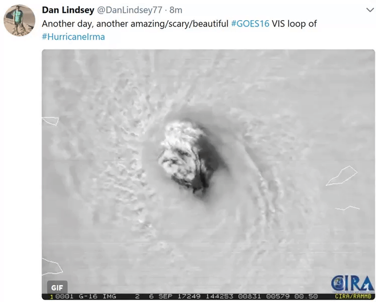
Irma: A Record-Shattering Hurricane. Colorado State put together a list of the records Irma has already broken. Click here for more information
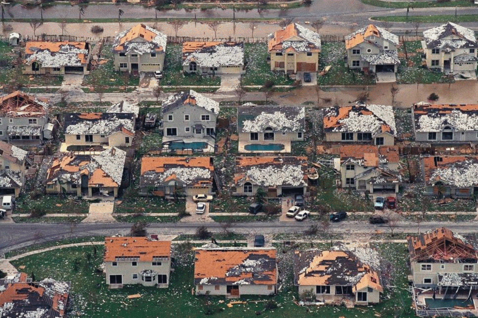
Insurer: Miami is More Vulnerable to Hurricanes Like Andrew. An August 9 article from AP and U.S. News proves to be almost prophetic: "Almost 25 years have passed since a Category 5 hurricane struck south of Miami, and the city's vulnerability to catastrophic storm damage has grown exponentially, according to a new insurance underwriters' analysis. At the time, Hurricane Andrew was the most expensive natural disaster in U.S. history, causing more than $26 billion of damage in Florida's most populous areas, including $15.5 billion in insurance payouts. Stringent building code enforcement followed in Miami, but so did population growth, coastal development and climate change. "Our concerns lie with the fact that even though we've made good changes, 25 years later you have a much larger population living in Florida, and people forget what can happen or they don't know what could happen," said Monica Ningen, chief property underwriter for the U.S. and Canada at Swiss Re..."
File photo credit: "In this Aug. 25, 1992, file photo, rows of damaged houses sit between Homestead and Florida City, Fla. Almost 25 years after Hurricane Andrew struck south of Miami, a new insurance underwriters' analysis says the city's vulnerability to another Category 5 hurricane has grown exponentially. (AP Photo/Mark Foley, File)." The Associated Press.
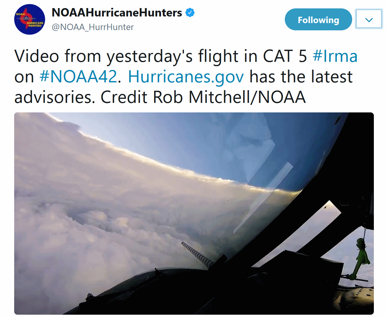
Flying Into Irma. Check out the video of punching into Irene's eye, courtesy of the Air Force Hurricane Hunters. America is the only country that flies into hurricanes to gather data, critical information that is fed into computer models, trying to fine-tune track and intensity.
Climate, Power, Money and Sorrow: Lessons of Hurricane Harvey. An essay at NPR struck a chord; here's the intro: "I get a lot of "climate" hate mail. Whenever I write a piece on global warming, someone will email to call me a "lie-bra-tard," or something similar, and tell me I should be in jail. Sometimes I try to engage these folks and see if they might be interested in how the science of climate change works and what it has to tell us. Mostly, they aren't. Mostly, what they really want is to score some points. What they really want is an argument. That's what climate change and climate science has become after all these years. It's just another political football getting tossed around on an already crowded field of political game playing. Immigration, health care, Russian hacking — climate change just gets tossed onto that pile. Then everyone watches to see who has the best zingers on the next CNN or Fox News panel..."
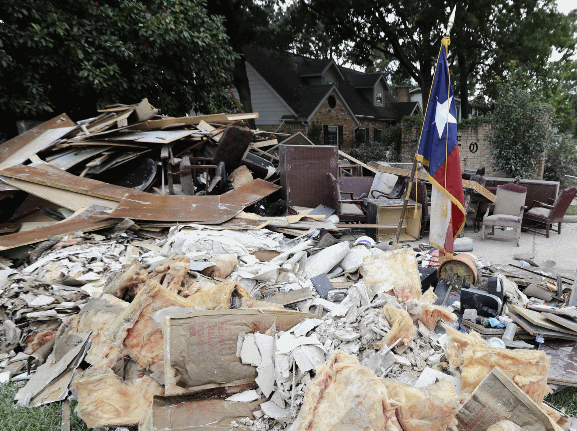
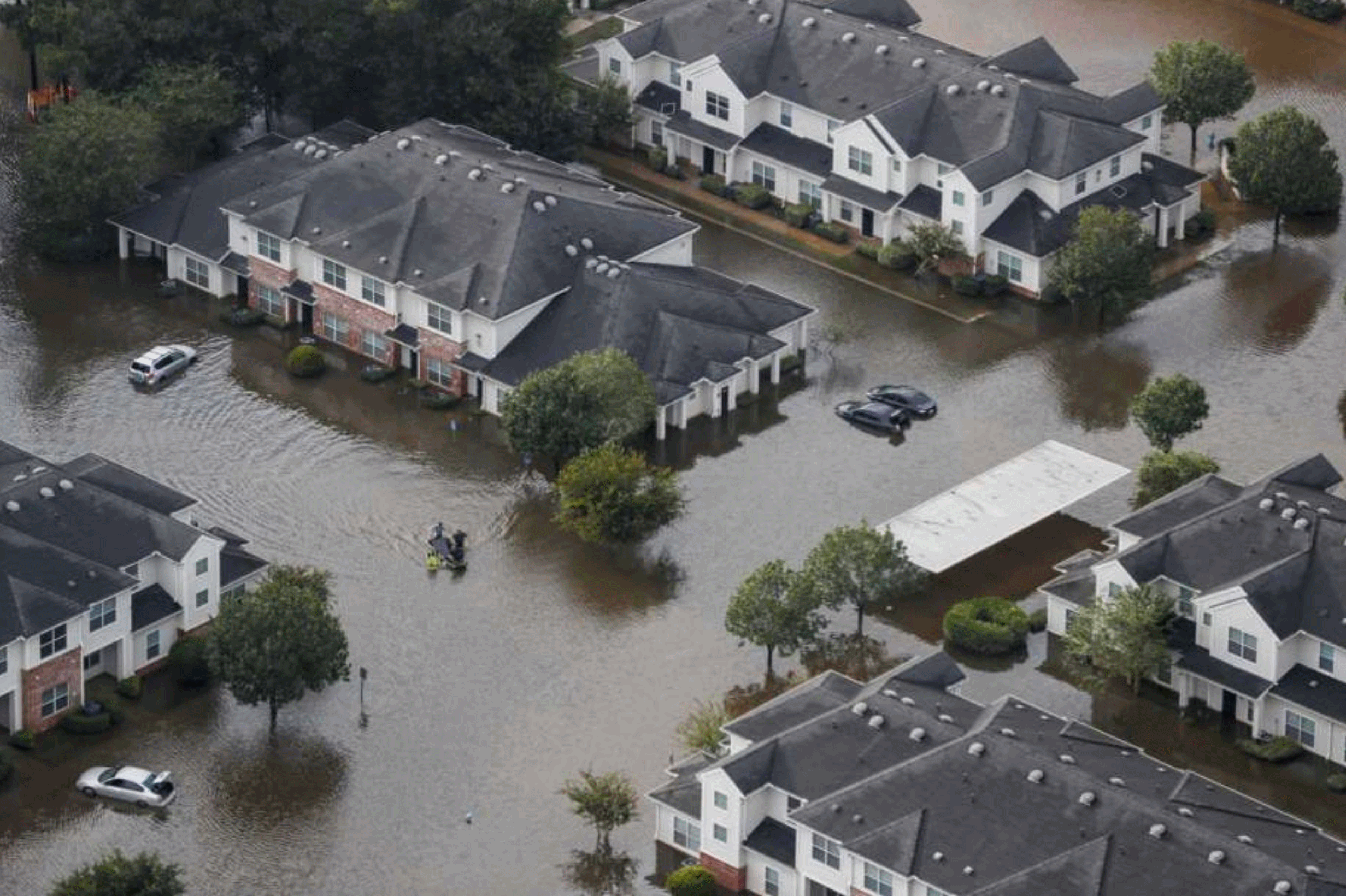
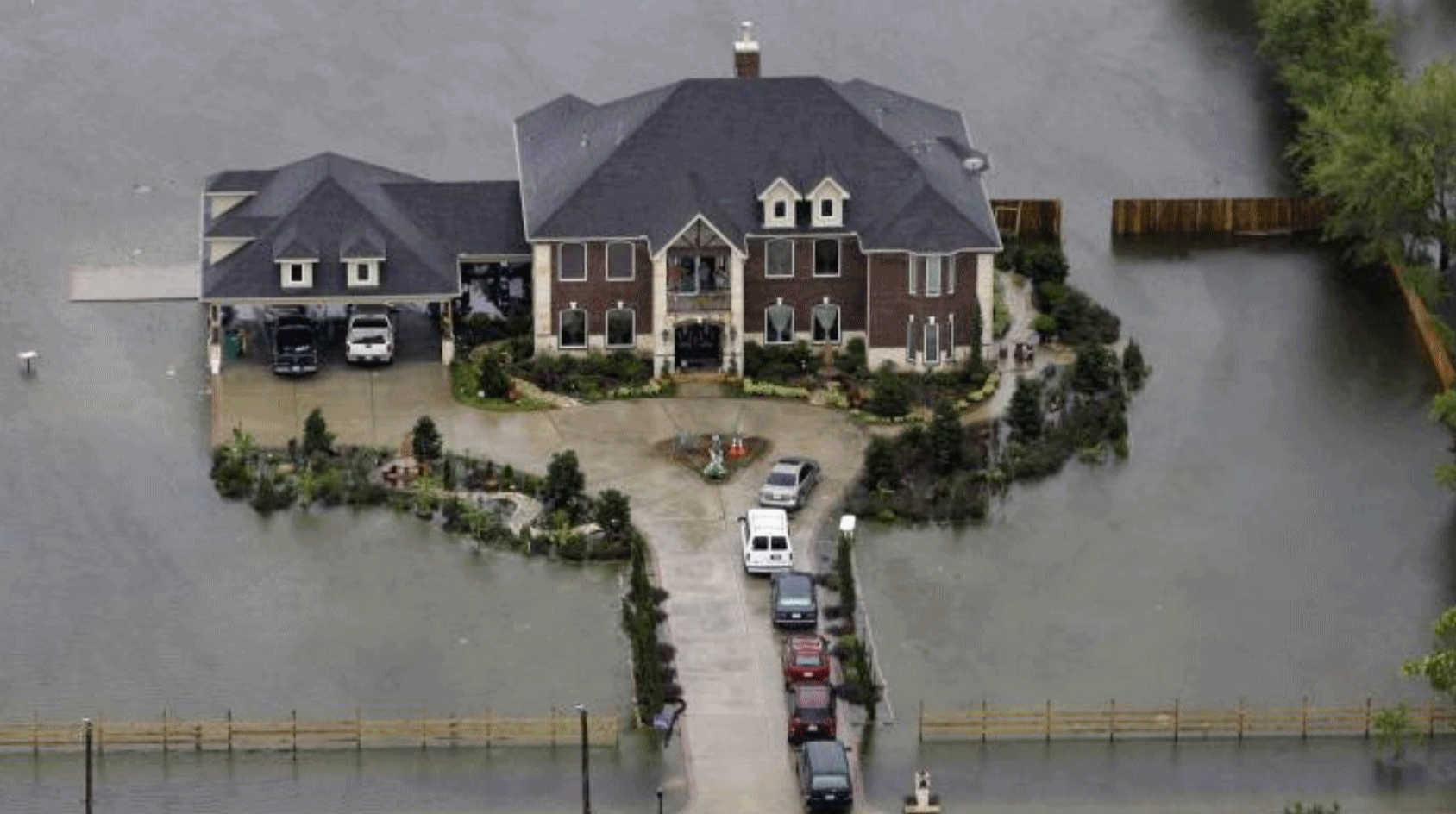
Photo credit: "A pile of debris sits outside a business damaged by floodwaters in the aftermath of Hurricane Harvey on Sept. 5 in Spring, Texas." David J. Phillip/AP.
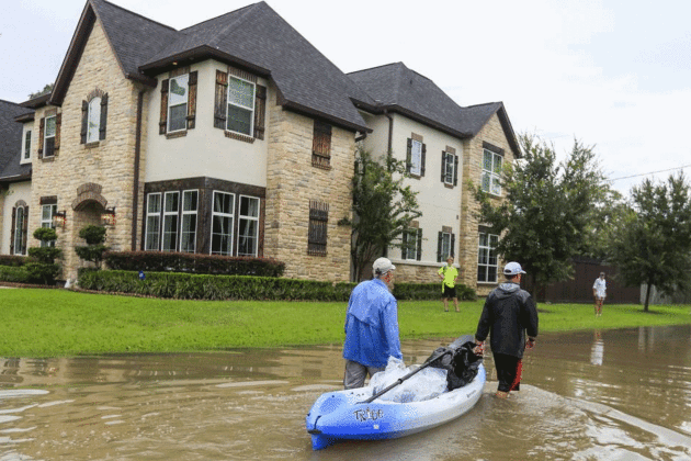
Photo credit: "People float belongings out of their flooded neighborhood in the aftermath of Hurricane Harvey, Houston, Texas, August 30." Photo: TANNEN MAURY/EPA-EFE/Shutterstock.
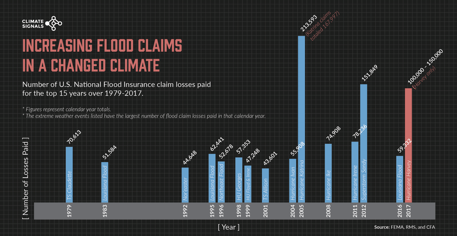
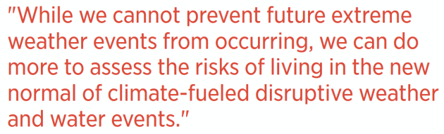
Increasing Flood Claims in a Changed Climate. Climate Signals takes a look at the trends: "The increasing frequency of US National Flood Insurance Program (NFIP) claims parallels the increasing frequency of extreme rainfall and flooding in the United States. The graphic above shows the number of NFIP claim losses paid for the top 15 years over 1979-2017. The data reveals an increasing trend in NFIP claims in the most recent decades, which is consistent with the increasing trend in extreme precipitation and heightened flood risk over this time. One of the clearest changes in weather globally is the increasing frequency of heavy rain.[1] Climate change is fueling extreme rainfall and dramatically increasing rainfall across many types of storms.[2][3] Over the past century, the US has witnessed a 20 percent increase in the amount of precipitation falling in the heaviest downpours.[4] Nationwide in the US, there has been a 40 percent increase in the number of five-year rain events, extreme events that have only a 20 chance of occurring in any given year..."[5]
Grist has more perspective and statistics on the western fires here.
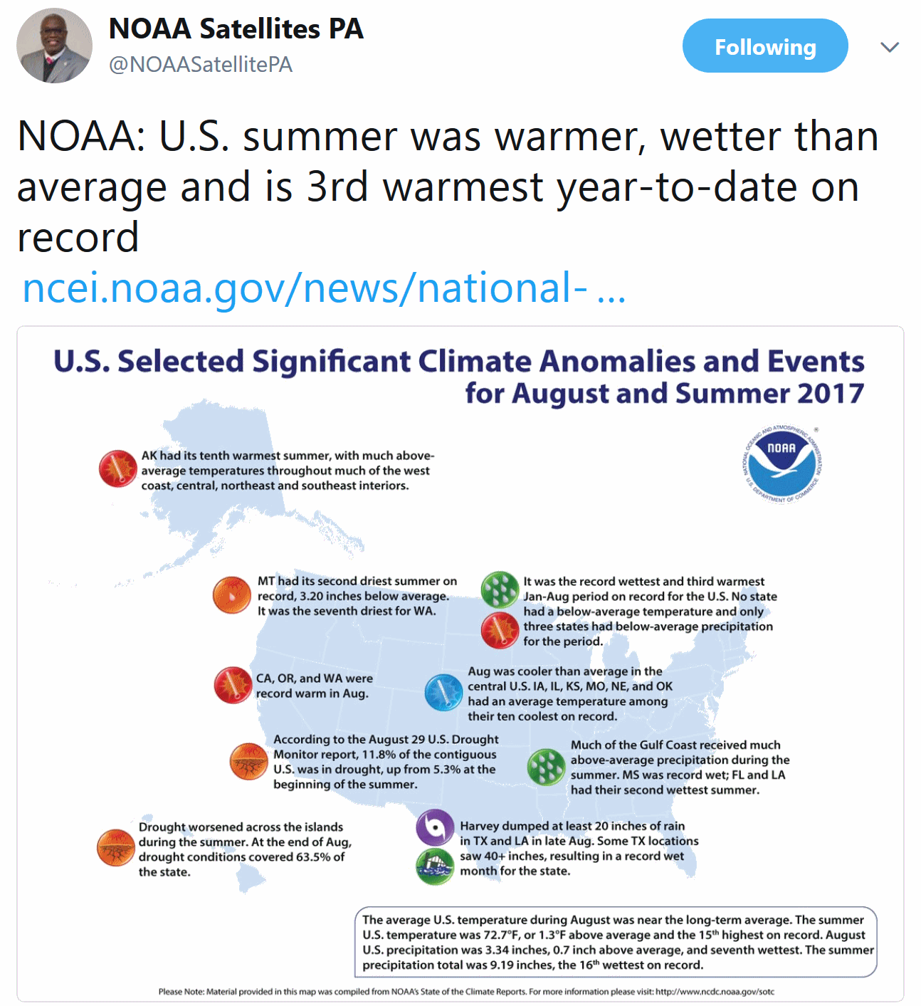
15th Warmest Summer on Record for USA. Details via NOAA NCEI: "Driven by record warmth in the West, the national average summer (June–August) temperature for the contiguous U.S. was 72.7°F, 1.3°F above average and the 15th warmest summer in the 123-year period of record. The season’s precipitation averageof 9.19 inches was 0.87 inch above average and the 16th wettest summer on record. For the month of August, much-below-average temperatures in the Midwest and High Plains offset the record warmth along the West Coast. The August national temperature was near average at 72.0°F, 0.1°F below average, tying 1921 as the 53rd coolest on record. The August precipitation average for the contiguous U.S. was 3.34 inches, 0.7 inch above average, the seventh wettest in the 123-year period of record..."
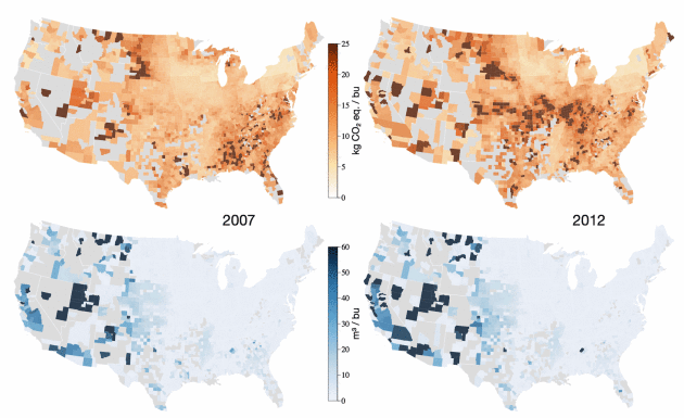
Map credit: "Variations in the greenhouse-gas emissions (kilograms per bushel) and irrigated water use (cubic meter per bushel) of U.S. corn production." Image courtesy of the Proceedings of the National Academy of Sciences.
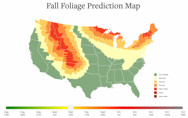
Map credit: "The 2017 Fall Foliage Map is the ultimate visual planning guide to the annual progressive changing of the leaves. While no tool can be 100% accurate, this tool is meant to help travelers better time their trips to have the best opportunity of catching peak color each year."
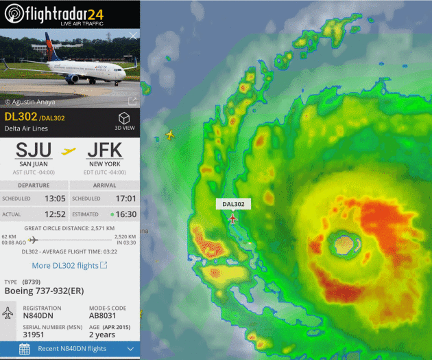
That Delta Plane Flying Straight Through Hurricane Irma Was No Big Deal. To be clear and accurate, it flew between Irma's feeder bands, not through the raging eyewall. Wired.com reports: "There are some places
that feel very safe. Like your bed. Or a corner booth at your favorite
diner. Or Mom's kitchen table. There are some places that feel very unsafe. Like in a commercial airliner in the middle of one of the most powerful hurricanes
ever recorded. But that's where 173 Delta passengers, plus flight crew,
found themselves Wednesday afternoon. Delta Flight 302, the last
commercial airplane to fly out of San Juan before the airport shut down
amid 185 mile-per-hour winds, rocketed out of Puerto Rico's San Juan
Luis Muñoz Marín International Airport in between bands of Category 5 Hurricane Irma. The flight safely made it to New York's JFK International Airport less than three and half hours later..."
Screengrab above: FlightRadar24.

TODAY: Partly sunny and pleasant. Winds: E 7-12. High: 70
FRIDAY NIGHT: Partly cloudy and comfortably cool. Low: 52
SATURDAY: Mix of clouds and mild sunshine. Wake-up: 53. Winds: SE 8-13. High: 74
SUNDAY: Patchy clouds, isolated shower? Winds: SE 8-13. Wake-up: 61. High: 77
MONDAY: Intervals of sun, few complaints. Winds: S 5-10. Wake-up: 61. High: near 80
TUESDAY: Fair weather holding pattern. Nice. Winds: S 5-10. Wake-up: 62. High: 81
WEDNESDAY: Dry streak continues. More blue sky. Winds: SE 8-13. Wake-up: 60. High: 79
THURSDAY: Partly sunny, feels like summer. Winds: SE 7-12. Wake-up: 59. High: 80
Climate Stories...
Hurricane Irma Made Worse by Climate Change, Scientists Say. Here's a snippet from Bloomberg: "...Unfortunately, the physicality is very clear: Hurricanes get their destructive energy from the warmth of the ocean, and the region’s water temperatures are super elevated,” said Anders Levermann, a climate scientist at the Potsdam Institute for Climate Impact Research, in an emailed statement on Wednesday. Irma comes less than two weeks after Hurricane Harvey smashed ashore in Texas, knocking offline almost a quarter of U.S. oil refining capacity and causing widespread damage, power outages and flooding. Climate change can “badly exacerbate” the impact of the hurricanes, even if it’s not the initial cause, he said..."
The Case for a Category 6 Rating for Super-Hurricanes like Irma. In a warming world the idea may not be as far-fetched as it sounds. Here's a clip from ThinkProgress: "...The Safir-Simpson scale for hurricanes is built around windspeed, and when it was being developed over four decades ago, people weren’t really focused on global warming and its role in fueling stronger and stronger hurricanes as long as we keep warming the Earth and its oceans. Hurricanes “extract heat energy from the ocean to convert it to the power of wind, and the warmer the ocean is, the stronger a hurricane can get,” meteorologist and former hurricane hunter Jeff Masters explained recently on Living on Earth. “So, scientists are confident that as we continue to heat up the oceans, we’re going to see more of these high-end perfect storms.” Masters went on to emphasize that “the strongest storms are going to get stronger, and we’re going to see a few storms with 200 plus miles per hour sustained winds like we saw you last year off the coast of Mexico with Hurricane Patricia...”
Image credit: AerisWeather.
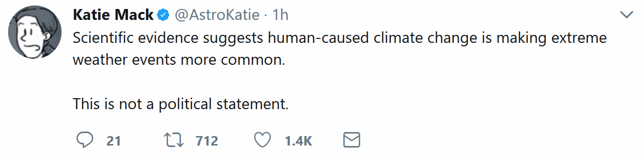
Houston - We Have a Problem. It's Called Global Warming. Is it super-sizing hurricanes or do Harvey and Irma fall under the heading of natural variability. Here's an excerpt from Forbes: "...A few facts: the Gulf of Mexico is 4 degrees warmer than normal this year, and it has been getting worse. Back in March of this year, the Washington Post's Jason Samenow reported that the Gulf was "freakishly warm, which could mean explosive springtime storms." Warm water feeds hurricanes, and Harvey feasted on it, sucking up energy and using it to dump ridiculous amounts of water onto south Texas. Noted climate scientist Michael Mann, writing in The Guardian, took the slightly more nuanced position that "climate change made Hurricane Harvey more deadly." True enough: if you want to be strictly accurate, we can't prove that warming temperatures are the sole cause of Harvey. Maybe with cooler temperatures, we'd have had a hurricane anyway–but it would have been a far smaller one, and the damage would have been far less severe..."
Will Climate Change Make Storms More Severe? An article at The Houston Chronicle caught my eye: "...Perhaps Houston will never again endure rains that were unprecedented in the history of the continental United States. But climate change will continue stacking the odds toward more extreme events. The world has warmed just 1 degree Celsius (2 degrees Fahrenheit) so far. Even fully achieving the goals of the Paris Agreement would double that; failing to act means risking an additional doubling, and the even more extreme weather events that would come with it. Thus, we face a future when both deluges of rain and blitzes of wind and surge will become ever greater risks. Evolving scientific understanding suggests that hurricanes might not become more frequent, but those that do form might become more severe and intensify with such astounding rapidity as Harvey did and Hurricane Patricia before it..."
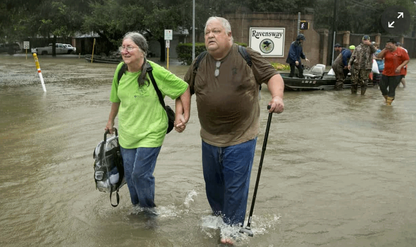
Photo credit: Brett Coomer, Staff. "For some area apartment dwellers facing a deadline to vacate their residences, the only way to return to their flooded complex is with a boat."
Climate Change Experts Weigh In on Why Houston Flooded During Hurricane Harvey. Check out an explainer at Texas Monthly: "...Scientists like Dessler, who has been studying climate change for twenty years, have long warned about the impact of global warming. They have patiently explained, over and over, that when too much carbon dioxide is added to the atmosphere, the earth’s heat is trapped, making it harder for energy to be sent radiating into space. According to the scientists, most of that trapped energy goes into the earth’s oceans. If carbon dioxide levels stay the same or get higher, the ocean water itself eventually gets warmer. Few bodies of water have heated up like the Gulf of Mexico. As a result, when a tropical storm passes over the Gulf, those warm waters become pure fuel for that storm to tap. What’s more, because the temperatures in the atmosphere over the Gulf are also warmer, more ocean water is evaporating and hanging in the air, just waiting to be swept up by a storm and dumped over land as rain..."
Photo credit: Jay Janner, AP.


Harvey and Climate Change: Why It Won't Change Minds. Here's an excerpt from a timely story at Axios: "...Some experts go even further to say that most people are in deep denial about what it would mean to address climate change, and Harvey won't affect that unless advocates of climate action start talking about it differently. Renee Lertzman, a psychosocial researcher for more than 20 years, works with environmental and energy organizations on this issue. She says pointing to Harvey and telling people who don't acknowledge climate science that this is how we're going to suffer if we don't act on climate change won't do any good. The message needs to be more compassionate and less condescending, Lertzman says. If this sounds like something you heard in therapy, that's because we're not far off. Coming to grips with a lot of things, be it a personal crisis or a global environmental problem, can bring up similar emotions. "We have to get out of that emotional loop we're in," Lertzman says. "Unless we actually talk about the trauma and anxiety about what it means to come to terms with our way of life then something like Harvey won't have any effect..."
Image credit: Rebecca Zisser / Axios.
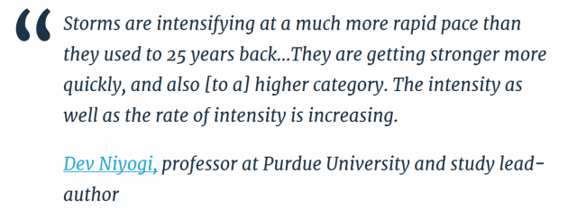
- Finds that hurricanes and other tropical cyclones across the globe reach Category 3 wind speeds nearly nine hours earlier than they did 25 years ago
- Finds that in North America, storms have shaved almost a day (20 hours) off their spin-up to Category 3
- Uses the International Best Track Archive for Climate Stewardship (IBTrACS, version v03r03) analysis during satellite era (1986–2010) and determines the trends of intensification of tropical cyclones (TC) over all the global basins, except the North Indian Ocean..."

Rush Limbaugh: Warnings About Irma Inflated to Advance "Climate Change Agenda". Dear Rush, please don't forget to take your meds. Here's a blurb from Tampa Bay Times: "Conservative
icon, radio giant, and Palm Beach resident Rush Limbaugh suggested to
his listeners today that the media and meteorologists are exaggerating
the threat from Hurricane Irma. In a breathtakingly irresponsible
monologue that literally could put lives at risk and directly
contradicts virtually every government official and expert of all
ideologies, Limbaugh said the attention on Irma is largely driven by
political and business agendas:...So there is a desire to
advance this climate change agenda, and hurricanes are one of the
fastest and best ways to do it. You can accomplish a lot just by
creating fear and panic. You don’t need a hurricane to hit anywhere. All
you need is to create the fear and panic accompanied by talk that
climate change is causing hurricanes to become more frequent and bigger
and more dangerous, and you create the panic, and it’s mission
accomplished, agenda advanced..."
Global Warming May Have Made the Impact of Hurricane Harvey Worse. Financial Times explains: "First, surface water temperatures in the Gulf of Mexico are higher because of global warming and helped to fuel Harvey, which rapidly strengthened within 24 hours from a category 1 hurricane to category 4 before making landfall on August 25. Second, sea level rise increased the height of Harvey’s storm surge that flooded coastal areas of Texas and neighbouring states. Third, the warmer atmosphere can hold more water vapour, helping to make the rainfall from Harvey more intense. The main reason that Houston and surrounding areas suffered such catastrophic flooding was because Harvey unusually stalled as a tropical storm, and dumped rainfall over the same area for several days, rather than passing over. We do not know yet if climate change influenced the atmospheric conditions that caused Harvey’s slow movement..."
Photo credit: AP.
No comments:
Post a Comment