76 F. average high on September 6.
81 F. high on September 6, 2016.
September 7, 1990: Strong winds and hail up to 2 inches was reported in Swift, Douglas, Stevens, Kandiyohi, Meeker, Stearns, and Waseca Counties.
September 7, 1986: A touch of winter is felt in northern MN, with lows of 20 degrees at Embarrass and 30 at Duluth.
September 7, 1922: The fifth consecutive day of 90 degrees or above occurs in the Minneapolis area.

Dry Streak Here While Florida Braces for Impact
If anyone asks, which I seriously doubt, this past summer was the 17th nicest June, July and August since 1867. The Minnesota DNR calculates a "Glory Index", factoring temperature, dew point and rainfall. All things considered we lucked out - no horrific tornadoes, biblical floods or ghastly heat.
While we worry about what color jacket the kids will wear at the bus stop residents of Florida are evacuating their homes in advance of "Irma". The strongest Atlantic hurricane ever measured, this catastrophic Category 5 storm inflicted severe damage from Barbuda & Antigua to the Virgin Islands.
Both NOAA and European models are converging on a track that takes a Category 4 storm into south Florida Sunday, before grinding up the coast. Storm surge damage from Miami to Daytona Beach may be severe, with a second landfall south of Charleston Monday. Good grief.
Dry weather prevails here into Monday with a warming trend. Low 80s are possible before Tuesday T-showers herald the next cool front.
If you have friends/family in Miami encourage them to pay attention & prepare to evacuate.

* to get a better sense of what living through a Category 5 hurricane is like, check out the Maho Beach webcam footage from yesterday on the island of St. Maarten, before the camera went dead. Unbelievable.


* Irma is the strongest Atlantic storm on record, with over 35 straight hours of sustained winds over 180 mph. The previous record was 18 hours > 180 mph during Hurricane Allen in 1980. I have never seen a hurricane like this in the Atlantic basin. Please take the calls for preparation and evacuation very seriously.
* The size, intensity and persistence of the storm is impressive - and alarming for locations in the path of this weather beast. Still an extreme Category 5 storm, Irma continues to produce sustained winds of 185 in the eyewall surrounding the eye, with gusts well over 200 mph.
* Some strengthening can't be ruled out Thursday, but conditions favor slight weakening by late week. Even so, odds favor Hurricane Irma impacting south Florida as a Category 4+ storm Saturday night and Sunday morning.
* If the eye of the storm tracks near or just west of Miami the impacts may be devastating, with the full force and fury of Irma's winds and storm surge impacting the city, as well as Fort Lauderdale and West Palm Beach. If Irma maintains Category 4-5 strength a storm surge over 10 feet may result; a potentially catastrophic impact. This is not a given, not yet, but models seem to be converging on a track along the eastern (Atlantic) coastline of Florida, one that favors severe wind and wave damage from Miami to Jacksonville.
* This storm is considerably larger and more intense than the last Category 5 storm to hit south Florida, Andrew, back in 1992. It's also approaching from the south, which will mean a much longer runway of coastal wind and storm surge (water) damage.
* Sunday looks like the worst day for most of Florida, but Monday will bring peak winds and waves from Jacksonville to Savannah, Hilton Head and Charleston.
* 00z Thursday NOAA model runs show a potential storm track just offshore, which may keep the strongest winds and heaviest surf just offshore. Not a sure thing, but there's at least at 30-40% chance that Irma may replicate Matthew's track off the coast last year.
* A second landfall is expected between Savannah and Charleston during the day Monday with severe flooding possible for coastal Georgia and South Carolina. The storm is progressive - unlike Harvey it's not expected to stall, so inland rainfall amounts will stay under 10-15" - still capable of flash flooding, but probably not the historic flooding we saw with Harvey in Houston.
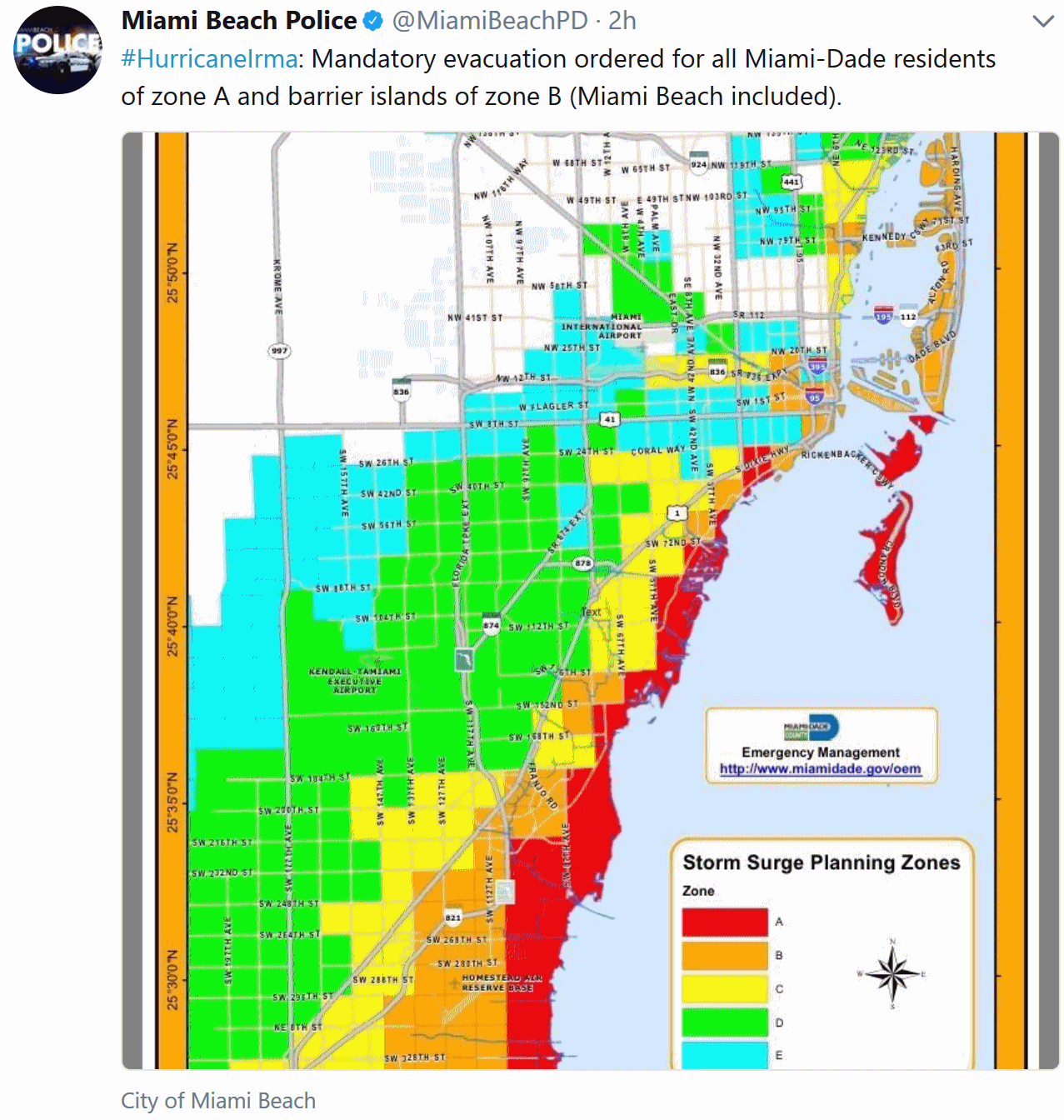
* Mandatory evacuations are now in place from the Florida Keys into much of Miami and Miami Beach. NOAA should issue a Hurricane Watch for much of Florida on Thursday. Evacuation plans should be finalized no later than midday Saturday, moving people away from vulnerable coastal areas on Florida's Atlantic coastline, or vertical evacuations (moving people into high-rise hotels and office buildings, away from outer walls and windows.
* The Gulf Coast of Florida will see 40-70 mph winds on Sunday, but Sarasota and the Tampa area will probably escape the worst of the storm.

STORM SURGE:  The combination of a life-threatening storm surge and
large breaking waves will raise water levels ABOVE NORMAL TIDE
LEVELS by the following amounts within the hurricane warning area
near and to the north of the center of Irma.  Near the coast, the
surge will be accompanied by large and destructive waves.

Turks and Caicos Islands...15 to 20 ft
Southeastern and central Bahamas...15 to 20 ft
Northern coast of the Dominican Republic...3 to 5 ft
Northern coast of Haiti and the Gulf of Gonave...1 to 3 ft
Northern coast of Cuba in the warning area...5 to 10 ft
Image credit above: AerisWeather AMP.


Summary: meteorologists are prone to superlatives, but Irma has all of us at Praedictix at a loss for words. We didn't think it could get worse than Harvey (an ex-hurricane stalling in one spot for 4-5 days?). We were wrong. Irma's size, intensity and tenacity is almost otherworldly. This is a storm that demands our respect. Tomorrow check out the damage photos and videos from the Virgin Islands, St. Marten, Antigua and Barbuda. This is worse than anything in the late 70s, possible the most severe hurricane ever recorded for some of the Leeward Islands. Puerto Rico was relatively lucky - it avoided the worst of the storm. My suggestion: accelerate preparations and staff evacuations from the most flood-prone locations of south Florida Thursday and Friday; no later than Saturday from Jacksonville to Savannah, Hilton Head and Charleston.
2017 is shaping up to be the most damaging and expensive hurricane year since 2005, when Katrina, Rita and Wilma hit. Texas government officials are already spitballing the damage from Harvey at $180 billion. If (and it's still a very big if) Irma tracks over or west of Miami, exposing the city to the full brunt of the storm surge, the damage price tag may eclipse Harvey by a wide margin. I hope I'm wrong, but I want to prepare you for what a worst-case scenario really means: Miami and suburbs out of commission for weeks, possibly longer, with a devastating blow to tourism and coastal real estate values that could take years to recover from. Hype? I sure hope so - let's hope Irma tracks 50 miles farther east, and a worst-case scenario for Miami is avoided. Stay tuned - the next briefing comes Thursday morning. Confidence levels are increasing, but a difference of 50-100 miles in the track will mean the difference between serious flooding and a full-blown catastrophe for Miami.
Good luck.
Paul Douglas, Senior Meteorologist, Praedictix


Hurricane Checklist.
Here's an excerpt of a story from CBS Miami outlining what Floridians
should have ready to go, just in case the evacuation order comes: "The National Hurricane Center suggests the following materials:
Water: At least 1 gallon of water per person/ animal per day for at least 3 days.
Food: At least a 3-day supply of non-perishable food.
Radio: A battery-powered radio with NOAA weather radio tone alert and extra batteries.
Flashlight: Make sure you have extra batteries as well.
First Aid Kit
Manual can opener: If the electricity is out, you would need some way to open your canned food.
Cellphone: Make sure you have extra battery packs or a solar charger to keep your phone on.
Prescription medications
Glasses
Cash
Important family documents: Make sure you have copies of insurance policies and some form of state issued ID.
Sturdy shoes: Think about pulling out those rain boots and sneakers.
Pet supplies: Your pets will need enough food and water to also weather out the storm with you.
If you have a generator, make sure you have propane. Also, try to top off your gas tank ahead of time, CBS Miami writes...

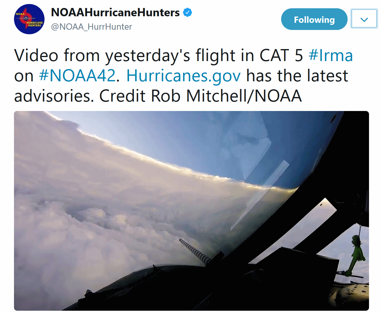
Flying Into Irma. Check out the video of punching into Irene's eye, courtesy of the Air Force Hurricane Hunters. America is the only country that flies into hurricanes to gather data, critical information that is fed into computer models, trying to fine-tune track and intensity.

Flying Into Irma. Check out the video of punching into Irene's eye, courtesy of the Air Force Hurricane Hunters. America is the only country that flies into hurricanes to gather data, critical information that is fed into computer models, trying to fine-tune track and intensity.

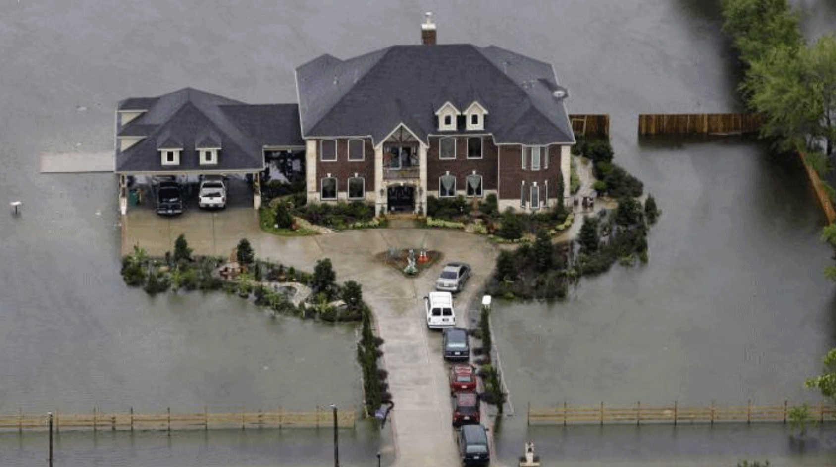
Hurricane Harvey Was America's 10th Billion-Dollar Disaster So Far in 2017. The Guardian has details: "...From 1980 to 2016, according to Noaa records, the US experienced an average of five and a half $1bn-plus “weather and climate disasters” a year. From 2012 to 2016, that reached 10.6 such events a year. Many such events are increasing in intensity, the agency warns. Such increases are chiefly due to a combination of climate change and people spreading into vulnerable areas, especially coasts and floodplains. There is an element of chance in where catastrophic weather systems hit, but another important factor is growing prosperity: Americans have more property to be damaged when serious weather strikes..."
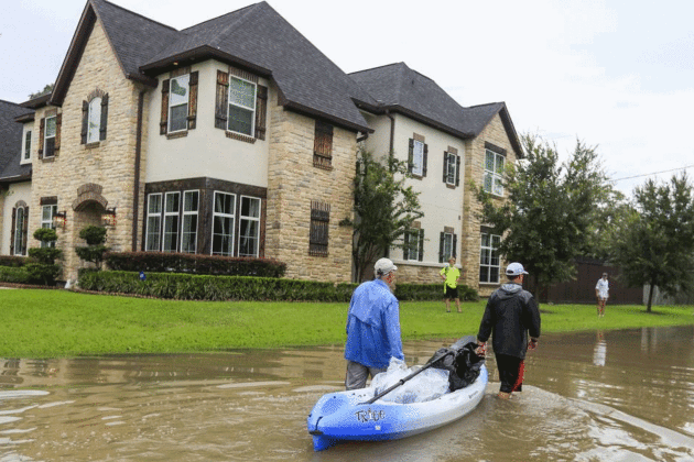
Photo credit: "People float belongings out of their flooded neighborhood in the aftermath of Hurricane Harvey, Houston, Texas, August 30." Photo: TANNEN MAURY/EPA-EFE/Shutterstock.

What Exactly Made Harvey So Nasty? The Associated Press asks the rhetorical question. The fact that it sat over Texas for the better part of 4-5 days turned a disaster into a catastrophe: "...Harvey was the first to go from tropical storm strength to major hurricane strength in its last 36 hours before U.S. landfall,” Rappaport said. Then it just stuck around. For more than 130 hours — from 10 a.m. Friday, Aug. 25, through 10 p.m. Wednesday, Aug. 30 — Harvey was raining over some part of eastern Texas. When Harvey did move, including a dip back into the Gulf of Mexico for about a day, it was still close enough to drench Texas. “It’s extremely rare to have a major hurricane that just sits there after it makes landfall,” McNoldy said. Usually strong storms blast through an area, dump a foot or so of rain, and move on. But Harvey was stuck between two high pressure weather systems to the east and west that kept pushing it in opposite directions, so it just staggered in a zig-zag pattern across southeast Texas..."
File photo: NASA International Space Station.

Above Devastated Houston, Armies of Drones Prove Their Worth. WIRED.com has details: "...Less than a week
after the last drops of Hurricane Harvey fell, Houston is just
beginning to assess the damage. At least 46 people have died. More than
30,000 houses are flooded and as many as a million vehicles waterlogged.
Early estimates suggest the hurricane has inflicted $120 billion in
damage on the region, making it the most expensive natural disaster in
the country’s history. “This is going to be a massive, massive cleanup
process,” Texas governor Greg Abbott told ABC’s Good Morning America
on Friday. “This is going to be a multiyear project for Texas to be
able to dig out of this catastrophe.” Which means the drones’ work has
just begun..."

Photo credit: "In this Aug. 31, 2017 file photo, Alejandra Castillo takes a break from carrying water-soaked items out of her family’s home after flood waters receded in Houston. Experts say Harvey’s filthy floodwaters pose significant dangers to human safety and the environment that will remain even after levels drop far enough that southeastern Texas residents no longer fear for their lives." (Charlie Riedel, File/Associated Press)

Harvey: A Storm Like No Other. Here's an excerpt of a story I wrote for EEN, The Evangelical Environmental Network: "...Then again Houston is no stranger to disruptive rains, having experienced three 500-year floods since 2015. Nationwide the National Weather Service counts 25 separate 500-year floods across the United States since 2010. It’s not your imagination: east of the Rockies the rain is falling harder and longer – wet areas are, in fact, trending wetter. Which is what climate models predicted 30 years ago. Jesus was explicit in Matthew 25:45. “Truly I tell you, whatever you did not do for one of the least of these, you did not do for me.” Many of us will be able to move away from incessant heat, wildfires, persistent drought and flooding coastlines. The well-to-do will move, build higher walls and flee the worst of an increasingly noxious climate. But the poorest among us won’t have any of these options. They can’t just pick up and move. Their homes are often closer to sea level, more vulnerable to storm surges and inland flooding. In the aftermath of Hurricane Harvey an estimated 70% of homeowners don’t have flood insurance, according to CoreLogic. The pain, disruption and dislocation of a rapidly-changing climate will be felt most by the world’s poor. That’s why climate volatility and weather disruption is emerging as the global civil rights struggle of the 21st century..."


Photo credit: "Mexican free-tailed bats sail through the night sky in Texas. People in that state can kill the animals if they're inside the house or on the roof." Photograph by Joel Sartore, National Geographic Creative.

Now That's a Hazard. Please, may I play through? There's a wall of flames on the 13th hole and I'm running out of daylight. Good grief - do these people love golf or what?
TODAY: Lukewarm sunshine. Winds: W 5-10. High: 73
THURSDAY NIGHT: Partly cloudy. Low: 52
FRIDAY: Blue sky with a fresh breeze. Winds: E 8-13. High: 71
SATURDAY: Mild sunshine, a fine September day. Wake-up: 55. High: 74
SUNDAY: Plenty of warm sunshine. Winds: SE 8-13. Wake-up: 59. High: 79
MONDAY: Warm sun, touch of humidity. Winds: S 7-12. Wake-up: 60. High: 81
TUESDAY: Passing shower or T-storm. Winds: NW 10-15. Wake-up: 61. High: 75
WEDNESDAY: Mostly cloudy with a cool breeze. Winds: NW 10-20. Wake-up: 55. High: 69
Climate Stories...
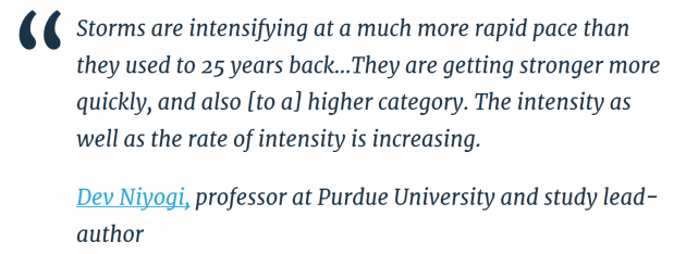
Tropical Cyclone Intensification Trends During Satellite Era (1986-2010). We aren't seeing more storms, but the hurricanes that do form tend to strengthen (faster). Here's a highlight of recent research at Climate Signals:
- Finds that hurricanes and other tropical cyclones across the globe reach Category 3 wind speeds nearly nine hours earlier than they did 25 years ago
- Finds that in North America, storms have shaved almost a day (20 hours) off their spin-up to Category 3
- Uses the International Best Track Archive for Climate Stewardship (IBTrACS, version v03r03) analysis during satellite era (1986–2010) and determines the trends of intensification of tropical cyclones (TC) over all the global basins, except the North Indian Ocean..."

Rush Limbaugh: Warnings About Irma Inflated to Advance "Climate Change Agenda". Hey Rush, don't forget to take your meds. Here's an blurb from Tampa Bay Times: "Conservative
icon, radio giant, and Palm Beach resident Rush Limbaugh suggested to
his listeners today that the media and meteorologists are exaggerating
the threat from Hurricane Irma. In a breathtakingly irresponsible
monologue that literally could put lives at risk and directly
contradicts virtually every government official and expert of all
ideologies, Limbaugh said the attention on Irma is largely driven by
political and business agendas:...So there is a desire to
advance this climate change agenda, and hurricanes are one of the
fastest and best ways to do it. You can accomplish a lot just by
creating fear and panic. You don’t need a hurricane to hit anywhere. All
you need is to create the fear and panic accompanied by talk that
climate change is causing hurricanes to become more frequent and bigger
and more dangerous, and you create the panic, and it’s mission
accomplished, agenda advanced..."
Global Warming May Have Made the Impact of Hurricane Harvey Worse. Financial Times explains: "First, surface water temperatures in the Gulf of Mexico are higher because of global warming and helped to fuel Harvey, which rapidly strengthened within 24 hours from a category 1 hurricane to category 4 before making landfall on August 25. Second, sea level rise increased the height of Harvey’s storm surge that flooded coastal areas of Texas and neighbouring states. Third, the warmer atmosphere can hold more water vapour, helping to make the rainfall from Harvey more intense. The main reason that Houston and surrounding areas suffered such catastrophic flooding was because Harvey unusually stalled as a tropical storm, and dumped rainfall over the same area for several days, rather than passing over. We do not know yet if climate change influenced the atmospheric conditions that caused Harvey’s slow movement..."
Photo credit: AP.

Denying Hurricane Harvey's Climate Links Only Worsens Future Suffering. I couldn't agree more. The Guardian connects the dots: "...Those who oppose climate policies will often argue that we can simply adapt to the consequences of human-caused climate change. Most recently, New York Times columnist Bret Stephens suggested that Harvey will just be a “speed bump” for Houston’s economy, and that the world should follow Houston’s example of “environmental resilience” by following “the path of its extraordinary economic growth.” The people in Texas suffering from having lost their homes and possessions probably aren’t comforted that Stephens considers Harvey a “speed bump” for the local economy (which coincidentally is probably not true). As renowned glaciologist Lonnie Thompson put it:
Global warming is here and is already affecting our climate, so prevention is no longer an option. Three options remain for dealing with the crisis: mitigate, adapt, and suffer.

Electric Cars and Renewables Not Enough to Meet Paris Climate Goal. Here's a snippet from Reuters: " The cost of electric vehicles (EVs) will fall to match those running on combustion engines by 2022, a key trigger that will mean by 2035 half of all passenger vehicles sold globally will be electric, according to the head of a top energy consultancy. But this expected exponential rise in cleaner vehicles, coupled with booming renewable energy production, will not be enough to meet the Paris Agreement goal of limiting climate warming, Ditlev Engel, chief executive of DNV GL’s energy consulting business, told Reuters in an interview. “The trends are very clear that the world is electrifying, renewables are taking up more space, we’re moving into a world of EVs, but we have to remember we are racing against the clock. It’s not enough...” (Photo: Triple Pundit).

California Heat Wave: How Much is From Climate Change. A warming climate is flavoring all weather now. Here's an excerpt from The Mercury News: "...The expectation has been that we are going to see more heat records, and that’s what we are seeing.” The number of heat records in recent years is startling. From 2000 to 2009, there were twice as many record daily high temperatures as daily record low temperatures in the United States, according to an analysis of hundreds of thousands of temperature records at 1,800 weather stations across the country done by the National Center for Atmospheric Research. So far in 2017, there have been nearly four times as many record hot days as record cold days. By 2050, at the current rates of warming, there are expected to be 20 times the number of heat records as cold records, the study found, and 50 times as many by 2100..."

Illustration credit: Grist / Amelia Bate.
No comments:
Post a Comment