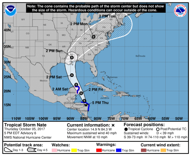
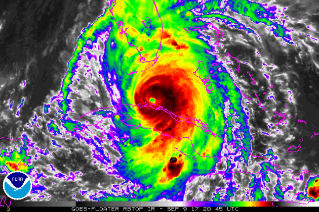
Tracking NATE in the Atlantic
Here's a look at NATE from midday Thursday, which according to NOAA's NHC, was a Tropical Storm with sustained winds of 40mph. Note that this is the fourteenth named storm the 2017 Atlantic Hurricane Season.
.gif)
Tracking NATE in the Atlantic
Tropical Storm NATE is expected to slowly strengthen over the next 72 hours as it moves over warm waters in the western Caribbean. Tropical Storm Warnings have been posted for parts of the Yucatan Peninsula in advance of NATE as it moves over the region late Friday and early Saturday. Models are coming into more agreement and show it tracking closer to the northern Gulf Coast early Sunday as a potential category 1 hurricane. There is still some uncertainty of exact strength and placement of the storm, but facilities from eastern Texas to the Panhandle of Florida should start preparing for tropical impacts this weekend.
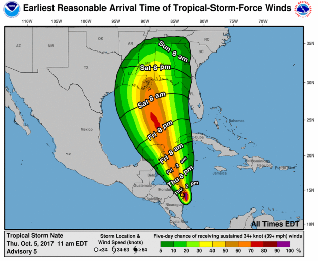
Timing of Tropical Storm Force Winds
Tropical Storm force winds will be possible across parts of the Gulf Coast from eastern Texas to the Panhandle of Florida as early as Saturday morning, but will likely increase as we head through the day Saturday and into Sunday.
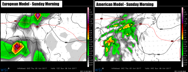
NATE Makes U.S. Landfall This Weekend
Both the European ECMWF (left) and the American GFS (right) show NATE making a landfall along the northern Gulf Coast later this weekend. There is still some uncertainty on the exact landfall, but both models are in better agreement than they were 24 hours ago. At this point, both models are converging on a solution that takes it closer to the Louisiana Coast early Sunday morning. We will know more on the exact path of NATE over the next couple of days, but facilities from eastern Texas to the Florida Panhandle should start to get contingency plans in place as impacts - including strong wind, storm surge and heavy rain - can be expected along and near the eventual landfall.
Atlantic Outlook Next 5 Days
Here's the Atlantic outlook over the next 5 days, which shows that things have heated back up again after a VERY active September. Remember that HARVEY, IRMA, JOSE and MARIA were all named storms during the month of September, which caused a lot of damage. Needless to say, we will be NATE very closely as it drifts north toward the Gulf Coast this upcoming weekend.
.png)
Watching The Tropics and the Southeast
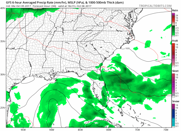
Here's the forecast from Friday into the weekend, which shows ongoing showers and storms across parts of Florida as a weak wave of energy continues to slide over the region. Meanwhile, NATE will also make its way toward the northern Gulf Coast as we head into the weekend with strong winds, storm surge and heavy rainfall.
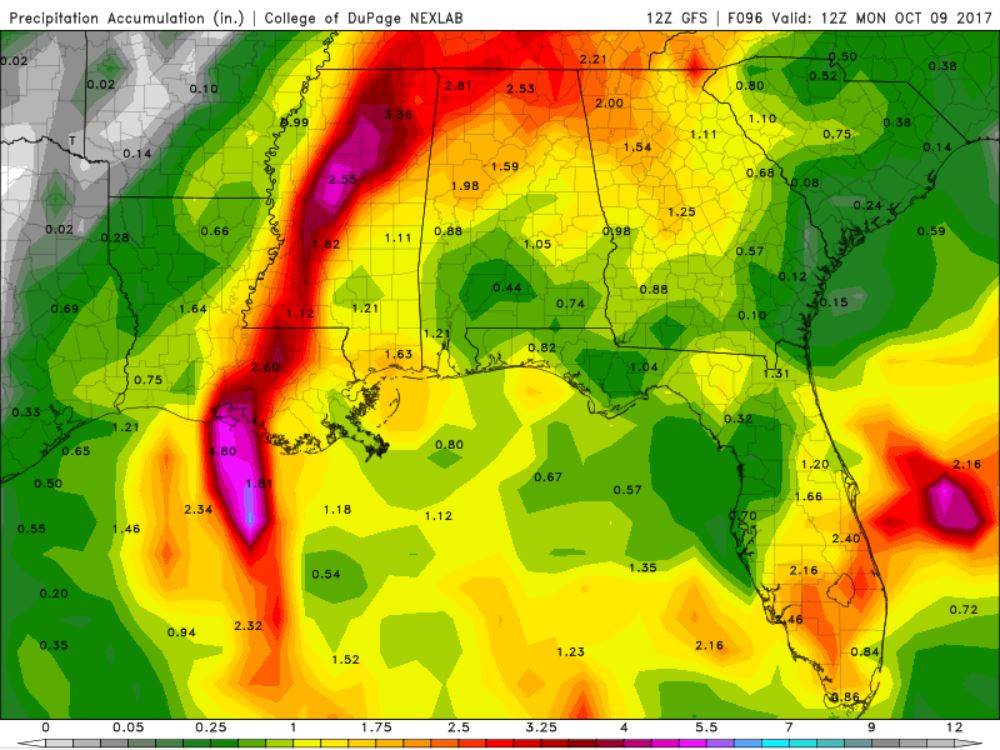
Heavy Rainfall Potential
Here's the rainfall potential through Monday morning, which suggests areas of heavy rain across Florida and across the southern US as NATE lifts north into the region. Some spots could see as much as 2" to 4" with localized areas of heavier rain.
__________________________________________________________
Active in the Eastern Pacific
Earlier this week RAMON developed in the Eastern Pacific, but has since diminished. The remnants of RAMON will continue to drift west, while the rest of the basin remains quiet.
.png)
___________________________________________________________
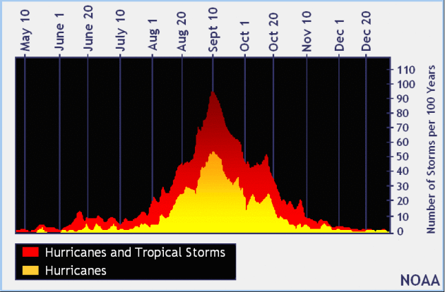
September 10th - Official Peak of the Atlantic Hurricane Season
Here's the average Atlantic hurricane season, which shows that peak activity generally occurs on September 10th and stays somewhat active through the month of October, but really diminishes through the month of November. Again, the Atlantic Hurricane Season doesn't officially end until November 30th.
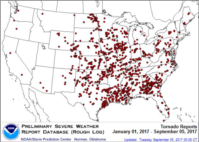
PRELIMINARY 2017 Tornado Map
It certainly has been a fairly active first half of 2017 with 1390 preliminary tornado reports through October 4th. Note that this is the most tornadoes through that date since 2011, when there were 1,796 reports. The map below shows the distribution of the tornadoes so far this year.
 PRELIMINARY 2017 Tornado Count
According to NOAA's SPC, the PRELIMINARY 2017 tornado count is 1390 (through October 4th). Note that is the most active year for tornadoes since 2011, when there were 1,796 tornadoes. Keep in mind there was a major tornado outbreak in the Gulf Coast region from April 25-28, 2011 that spawned nearly 500 tornadoes, some of which were deadly. That outbreak is known as the Super Outbreak of 2011 and has gone down in history as one of the biggest, costliest and one of the deadliest tornado outbreaks in history.
.png)
_____________________________________________________________________
According to NOAA's SPC, the PRELIMINARY 2017 tornado count is 1390 (through October 4th). Note that is the most active year for tornadoes since 2011, when there were 1,796 tornadoes. Keep in mind there was a major tornado outbreak in the Gulf Coast region from April 25-28, 2011 that spawned nearly 500 tornadoes, some of which were deadly. That outbreak is known as the Super Outbreak of 2011 and has gone down in history as one of the biggest, costliest and one of the deadliest tornado outbreaks in history.
_____________________________________________________________________
2.) Heavy rain across portions of the Mid-Atlantic and Northeast, Tue, Oct 10.
3.) High winds across portions of the Southeast and the Lower Mississippi Valley, Sun, Oct 8.
4.) High significant wave heights for coastal portions of the Gulf Coast, Sun, Oct 8.
5.) Heavy snow across portions of the Central and Northern Plains, Mon, Oct 9.
6.) High winds across portions of the Central Great Basin and California, Sun-Mon, Oct 8-Oct 9.
7.) High winds across portions of the the Northern Plains and the Northern Rockies, Sun, Oct 8.
8.) Flooding possible across portions of the Upper Mississippi Valley and the Northern Plains.
9.)Flooding occurring or imminent across portions of the Southeast and the Southern Plains.
Flooding likely across portions of the Northern Plains.
10.) Slight risk of much below normal temperatures for portions of California and the Pacific Northwest, Fri-Sat, Oct 13-Oct 14.
11.) Severe Drought across the Central Plains, the Northern Plains, Hawaii, the Northern Rockies, the Middle Mississippi Valley, and the Upper Mississippi Valley.
.png)
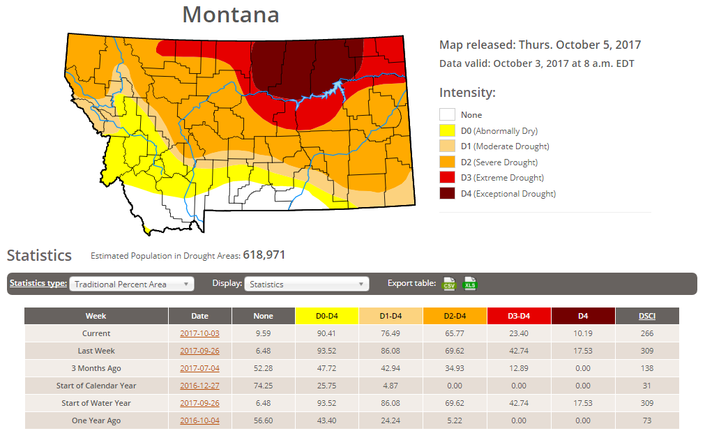
Latest Drought Monitor
Here's the latest drought update from the US Drought Monitor, which shows EXCEPTIONAL drought conditions continuing across parts of Montana. Note that nearly 90% of the state is considered to be abnormally dry, but the EXCEPTIONAL drought covers nearly 10% of the state, which is down from nearly 18% from last week. In North Dakota, less than 1% is in an EXCEPTIONAL drought, but nearly 3% of the state is still in an EXTREME drought, which is also the same as last week.
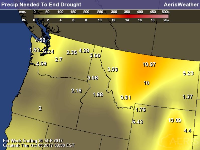
Rain Needed to End Drought
Thanks to recent cool and wetter weather, drought conditions have been improving, but we still need nearly 6" to 12" to end the drought in these locations.
____________________________________________________________________
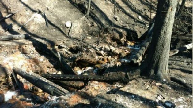
Rice Ridge Fire - 1.4 Miles NE of Seeley Lake, MT
The Rice Ridge Fire near Sleeley Lake, MT is another very large wildfire that started on Monday, July 24th due to lightning. The fire has grown to more than 160,000 acres and is 95% contained. There are 37 people working on the fire and they hope to have it fully contained by Sunday, October 15th.
"The Northern Rockies Wildland Fire Management Team is transitioning with the local Type 3 organization Tuesday Oct 3 at 6 p.m. Remaining operations will be managed by Phil Shilmerdine, Incident Commander. The Rice Ridge Fire was detected on July 24, 2017. It grew to the current size of over 160,000 acres. With a change of the weather and the onset of fall, fire activity has significantly slowed although firefighters and engines continue to patrol and cool hot spots that are near the fire's edge. The perimeter in the Scapegoat and Bob Marshall Wildernesses are continually monitored for heat and fire activity."
See more from inciweb HERE:
(Image Credit: Inciweb - taken on 10/3/2017)
 Diamond Creek Fire - Mazama, Washington
The Diamond Creek Fire near Mazama, Washington is a very large wildfire in the Western US that started on Sunday, July 23rd and has grown to more than 128,000 acres! There are nearly 19 people working on this fire, which is 85% contained. The estimated containment date is set for Sunday, October 15th.
"Incident Summary: The Diamond Creek Fire was reported on July 23, 2017 at approximately 9:45 a.m. The fire is burning in the Pasayten Wilderness and Eightmile drainage about 11 miles north of Mazama, Washington. Smokejumpers responded to the fire within two hours of it being reported. However, due to extreme terrain, heavy dead and down timber, and critical fire weather conditions, the fire was unable to be contained during initial response. The fire crossed into Canada on August 29. Fire managers recognized that the Diamond Creek Fire would likely be a long term event. Monitor, confine and point protection strategies are being used inside the Pasayten Wilderness. Outside the wilderness, the fire is being managed under a suppression strategy using a mixture of direct, indirect and point protection tactics when and where there is a high probability of success. Fire personnel will engage the fire at the appropriate time and location, while keeping public and firefighter safety as the top priority. Fire personnel are currently focused on identifying and implementing suppression repair work on the primary and contingency control lines. The suppression repair will not compromise the intended purpose of the control lines should they be needed at a later date."
See more from Inciweb HERE:
(Night time picture of a glowing yurt Credit: Brent Tannehill)
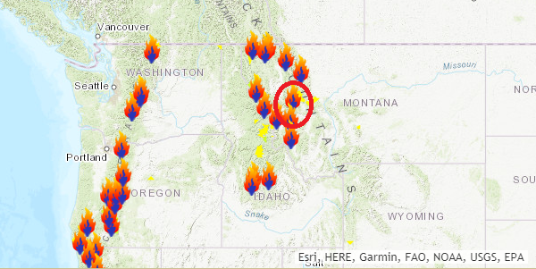
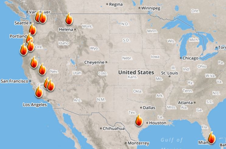
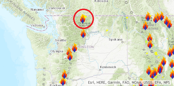 Ongoing Large Wildfires
Here's a look at the current wildfire map across the country. While several fires are still ongoing, recent cool and somewhat wet weather has been helping curb the wildfire threat, especially in the Western US.
Here's a list of all the current large wildfires from Inciweb:
The Rice Ridge Fire near Sleeley Lake, MT is another very large wildfire that started on Monday, July 24th due to lightning. The fire has grown to more than 160,000 acres and is 95% contained. There are 37 people working on the fire and they hope to have it fully contained by Sunday, October 15th.
"The Northern Rockies Wildland Fire Management Team is transitioning with the local Type 3 organization Tuesday Oct 3 at 6 p.m. Remaining operations will be managed by Phil Shilmerdine, Incident Commander. The Rice Ridge Fire was detected on July 24, 2017. It grew to the current size of over 160,000 acres. With a change of the weather and the onset of fall, fire activity has significantly slowed although firefighters and engines continue to patrol and cool hot spots that are near the fire's edge. The perimeter in the Scapegoat and Bob Marshall Wildernesses are continually monitored for heat and fire activity."
See more from inciweb HERE:
(Image Credit: Inciweb - taken on 10/3/2017)
Diamond Creek Fire - Mazama, WashingtonThe Diamond Creek Fire near Mazama, Washington is a very large wildfire in the Western US that started on Sunday, July 23rd and has grown to more than 128,000 acres! There are nearly 19 people working on this fire, which is 85% contained. The estimated containment date is set for Sunday, October 15th.
"Incident Summary: The Diamond Creek Fire was reported on July 23, 2017 at approximately 9:45 a.m. The fire is burning in the Pasayten Wilderness and Eightmile drainage about 11 miles north of Mazama, Washington. Smokejumpers responded to the fire within two hours of it being reported. However, due to extreme terrain, heavy dead and down timber, and critical fire weather conditions, the fire was unable to be contained during initial response. The fire crossed into Canada on August 29. Fire managers recognized that the Diamond Creek Fire would likely be a long term event. Monitor, confine and point protection strategies are being used inside the Pasayten Wilderness. Outside the wilderness, the fire is being managed under a suppression strategy using a mixture of direct, indirect and point protection tactics when and where there is a high probability of success. Fire personnel will engage the fire at the appropriate time and location, while keeping public and firefighter safety as the top priority. Fire personnel are currently focused on identifying and implementing suppression repair work on the primary and contingency control lines. The suppression repair will not compromise the intended purpose of the control lines should they be needed at a later date."
See more from Inciweb HERE:
(Night time picture of a glowing yurt Credit: Brent Tannehill)
Here's a look at the current wildfire map across the country. While several fires are still ongoing, recent cool and somewhat wet weather has been helping curb the wildfire threat, especially in the Western US.
Here's a list of all the current large wildfires from Inciweb:
_________________________________________________________________________
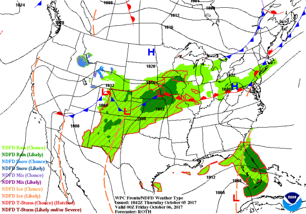
National Weather Outlook
Here's the weather outlook into the weekend, which shows areas of heavy rain across parts of the Midwest, while NATE moves into the Gulf Coast region with strong winds, heavy rain and coastal flooding.
5 Day Precipitation Outlook
According to NOAA's WPC, the next several days could produce very heavy rainfall across parts of the Midwest and from NATE as it lifts north from the Gulf Coast to the Northeast. Widespread 2" to 4" can be expected, but heavier amounts can't be ruled out.
.gif)
.png) ________________________________________________________________________
________________________________________________________________________
Snowfall Potential
Storm systems will continue to push through the northwestern US with areas of moisture that will get wrapped in the higher elevations into snow.
________________________________________________________________________
Happy Slop-tober! Another 1"+ Possible in S. MN.
By Todd Nelson, filling in for DouglasThanks to the likes of Harvey, Irma, Jose, Lee and Maria the Atlantic Basin recently ended its 3rd longest stretch of named storm days at nearly 38.
It was an impressive run and things are heating up again after a brief lull in activity. NATE is on track to impact the Gulf Coast as a hurricane late this weekend. There is still some uncertainty on the exact landfall and strength, but latest models are converging on a potential category 1 storm making landfall near Louisiana on Sunday.
Meanwhile, a months worth of rain has already fallen across parts of Minnesota this month and more is on the way. Another slop-tober storm will soak parts of the state with more than 1 inch of rain Friday and early Saturday.
Skies brighten later Saturday and much of Sunday, which will give you a chance to do some fall color peeping. According to the MN DNR, colors are peaking across the northern half of the state and should soon follow here in the metro.
Next weeks cold front could feature more widespread frost up north. Stay tuned!
________________________________________________________________________
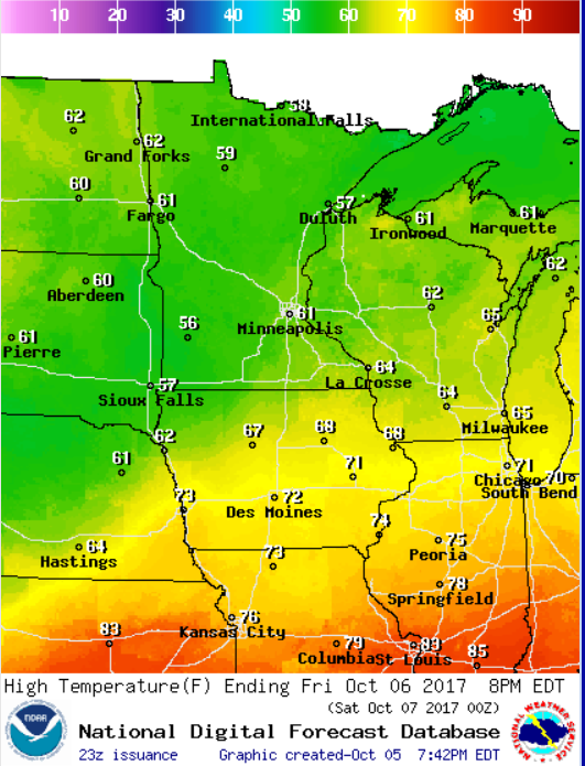
Extended Forecast
FRIDAY: Steady rains develop. Winds: NE 5-15. High: 63.
FRIDAY NIGHT: Showers likely. Winds: NNW 5. Low: 53
SATURDAY: AM showers, PM clearing. Winds: WSW 5-15. High: 64.
SUNDAY: Bright sun returns. Great for Fall color peeping. Winds: NNW 5-10. Wake-up: 50. High: 68.
MONDAY: Dry start. Rain develops late. Winds: NNE 5-10. Wake-up: 47. High: 64.
TUESDAY: Quite chilly with scattered showers. Winds: N 10-15. Wake-up: 43. High: 56.
WEDNESDAY: AM frost up north. Lingering shower. Winds: NW 5-10. Wake-up: 39. High: 59.
THURSDAY: Quiet October day. Winds: NNE 5. Wake-up: 48. High: 60.
_______________________________________________________
This Day in Weather History
October 6th
October 6th
1997: Hail, wind, and an F0 tornado are reported in the early morning hours in several counties in west central Minnesota. Near Canby in Yellow Medicine County, hail combined with wind gusts nearing 60 mph damage the roof of a bus garage, elementary school windows and a school vehicle. Renville, McLeod, Carver, Scott, and Dakota counties also receive hail and strong winds. Widespread pea to marble size hail accumulates to three inches deep in several areas, and crops are severely damaged over a large part of Renville county. Many power lines and trees are blown down. Southeast of Bird Island, a barn collapses and kills over 100 pigs. Near Brownton in McLeod County, hail accumulates to a depth of 3 inches with one foot drifts. A brief tornado touches down near Stewart in McLeod County, damaging a few trees.
1987: Snow falls over the Arrowhead region.
________________________________________________________
________________________________________________________
Average High/Low for Minneapolis
October 6th
October 6th
Average High: 63F (Record: 87F set in 2007)
Average Low: 43F (Record: 25F set in 1873)
Average Low: 43F (Record: 25F set in 1873)
Record Rainfall: 1.69" set in 1941
Record Snowfall: Trace set in 2005
_________________________________________________________
Record Snowfall: Trace set in 2005
_________________________________________________________
Sunrise/Sunset Times for Minneapolis
October 6th
October 6th
Sunrise: 7:17am
Sunset: 6:44pm
Sunset: 6:44pm
Hours of Daylight: ~11 hours 26 mins
Daylight LOST since yesterday: ~3 minutes and 5 seconds
Daylight LOST since summer solstice (June 20th): 4 hours & 11 minutes
__________________________________________________________
Daylight LOST since summer solstice (June 20th): 4 hours & 11 minutes
__________________________________________________________
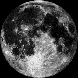
Moon Phase for October 6th at Midnight
1.5 Days After Full "Harvest" Moon
1.5 Days After Full "Harvest" Moon
"Oct. 5, 2:40 p.m. EDT– Full Harvest Moon. Traditionally, this designation goes to the September full moon that occurs closest to the autumnal (fall) equinox. This year's Harvest Moon comes unusually late. At the peak of the harvest, farmers can work into the night by the light of this moon. Usually, the moon rises an average of 50 minutes later each night, but for the few nights around the Harvest Moon, the moon seems to rise at nearly the same time each night: just 25 to 30 minutes later across the U.S., and only 10 to 20 minutes later for much of Canada and Europe. Corn, pumpkins, squash, beans and wild rice — the chief staples of Native Americans — are now ready for gathering."
_________________________
Weather Outlook For Friday
Temps on Friday will be a little cool for this time of the year as readings warm into the upper 50s and low 60s across much of the state.
__________________________________________________________________________
Simulated Radar Ahead...
Here's the simulated radar across the Upper Midwest from Friday to Saturday night, which suggests a fairly soggy outlook another wave of rain rolls through the region. Rainfall tallies could add up to 1"+ or more
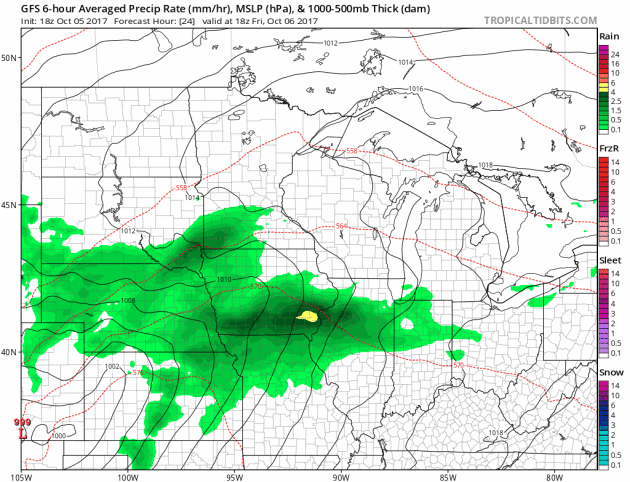
Rainfall Potential Ahead
Here's the rainfall potential through early next week, which shows widely scattered 1" to 2"+ tallies across southeastern Minnesota.
.png)
______________________________________________________
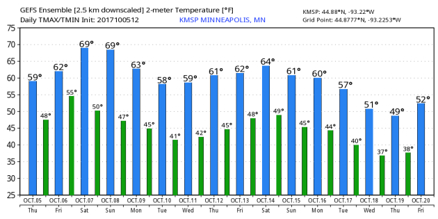
Minneapolis Temperature Outlook
Here's the temperature outlook through October 20th, which shows temps closer to average through the the middle par of October. However, we're getting indications of a cooling trend by the end of the month as we fall into 50s.
_________________________________________________________________
Minnesota Fall Color Update
According the MN DNR, much of the state is starting to see hints of fall color, however, much of northern Minnesota is peaking right now with pockets of past peak colors!
Follow along as the fall colors change with the MN DNR map HERE:
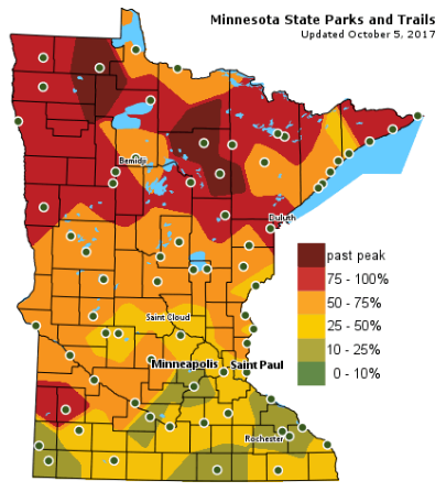
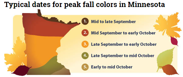
Typical Fall Color Peak in Minnesota
Here are the typical fall color peak times across the state of Minnesota and note that areas along the northern tier of the state usually see their peak toward the 2nd half of September. However, peak color usually doesn't arrive in central Minnesota until October, but we're getting close.
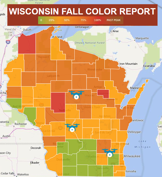
Wisconsin Fall Color Update
We're also seeing quite a bit of color show up across the northern half of Wisconsin with many locations now nearing 50%-100% color!
See more from Travel Wisconsin HERE:
_________________________________________________________________
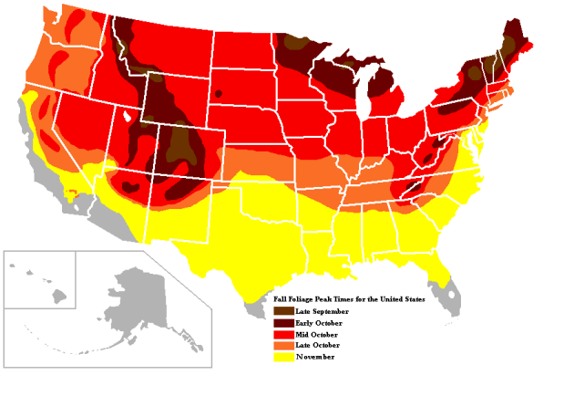
Typical Fall Color Times Across the Country
Here are the typical fall color peak times across the country, which suggests that much of the peak across the northern half of the nation usually wraps up through the month of October.
 _____________________________________________________________________
Follow along as the fall colors change with the MN DNR map HERE:
Typical Fall Color Peak in Minnesota
Here are the typical fall color peak times across the state of Minnesota and note that areas along the northern tier of the state usually see their peak toward the 2nd half of September. However, peak color usually doesn't arrive in central Minnesota until October, but we're getting close.
Wisconsin Fall Color Update
We're also seeing quite a bit of color show up across the northern half of Wisconsin with many locations now nearing 50%-100% color!
See more from Travel Wisconsin HERE:
_________________________________________________________________
Typical Fall Color Times Across the Country
Here are the typical fall color peak times across the country, which suggests that much of the peak across the northern half of the nation usually wraps up through the month of October.
"Why Hurricane Harvey Was Good News For Car Companies"
"Hurricane Harvey wreaked havoc across swaths of Texas and Louisiana, damaging billions of dollars’ worth of property in its path. That includes cars, many of which needed to be replaced, resulting in a bittersweet sales boost for a number of automakers. Major automakers are reporting record sales figures for September pretty much across the board: General Motors reported a 12% increase in year-over-year sales to 279,397 units; Toyota’s North American business was also bustling, with a 14.9% increase — compared to Sept. 2016 — to 226,632 cars last month; and Ford’s [PDF] sales were up by 8.7% over last year, with a total of 169,544 vehicles sold at retail. Fiat Chrysler, however, had a 10% decrease in sales, even though its retail sales were up 0.3%. That’s because of a planned reduction in how many cars it sells to rental companies. A lot of these increases can be attributed to post-storm purchases: Ford says it sold about 500,000 additional vehicles last month because of Harvey, Mark LaNeve, the company’s U.S. sales chief told reporters on a conference call today reported by Bloomberg."
(Image Courtesy: Kino Praxis Via Consumerist)

______________________________________________________________
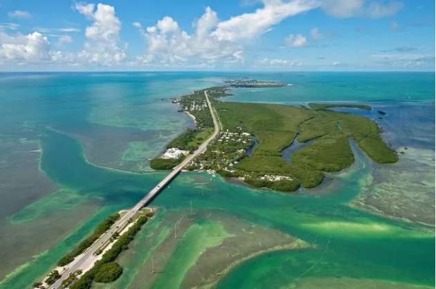
"Florida Keys Reopens to Tourists After Hurricane Irma"
"The Florida Keys announced Monday, October 2, that it has reopened to visitors despite significant damage due to Hurricane Irma just three weeks ago. The island chain officially reopened Sunday, October 1, which marked three weeks after Irma passed over the Keys on September 10. Local officials reopened so fast due to the speedy completion of significant infrastructure repairs, almost total restoration of utilities, and the necessity of resuming the tourism-driven economy that employs about 50 percent of the Florida Keys workforce. This means anglers from all over the world can take advantage of the Keys' famous inshore and offshore fishing opportunities. Stacey Mitchell, director of marketing for the Florida Keys tourism council, said welcoming tourists back to the popular destination "will provide jobs and the hope that our residents are looking for so they can begin to rebuild their lives."While Key Largo and Key West dodged major impact from the hurricane, a number of lodging properties and other tourism facilities haven’t yet resumed normal operations. Recovery efforts continue, particularly in the Lower Keys and parts of Marathon that were hit hardest by the storm."
(Courtesy Andy Newman / Florida Keys News Bureau VIA SportFishingMag.com)
_____________________________________________________________________
"The National Hurricane Center’s communication during Irma was not a problem"
"The author, James Franklin, worked at the National Oceanic and Atmospheric Administration for 35 years, the last 17 years at National Hurricane Center, and recently retired. He writes the following response to this perspective by Bryan Norcross: Hurricane Center creates great forecasts, but its communications system gets in the way. I’m struggling to understand Bryan Norcross’s issues with National Hurricane Center messaging during Hurricane Irma’s approach to South Florida. He seems to be concerned that Miami residents think they dodged a bullet — that Irma was forecast to hit Miami but turned away and hit Naples instead. I’m not sure why that impression on the part of Miami residents should be a concern. Norcross believes that the publicly available message was all about Miami, but the National Hurricane Center’s forecasts at various times showed tracks along both the east and west coasts of Florida. The first National Hurricane Center (NHC) forecast graphic to show a Florida landfall (Advisory 28, issued at 11 p.m., Sept. 5) showed landfall occurring in the Lower Keys, with the cone encompassing all of south Florida. From 11 a.m., Sept. 6, to 5 p.m., Sept. 7, Miami indeed fell almost directly on the forecast track. With the 11 p.m. advisory Sept. 7, however, more than two days before landfall, the NHC forecast track began to shift westward away from Miami. Thirty-six hours in advance (and thereafter) the NHC forecast graphics showed the center crossing the Lower Keys. In all of these forecast graphics, all of South Florida was within the cone."
_____________________________________________________________________
"Did a Meteorite Start a Forest Fire in New Hampshire? It's Unlikely"
"A three-alarm forest fire in the White Mountains near Woodstock, New Hampshire was linked to reports of a meteorite strike, the Boston Globereported on Wednesday. On Tuesday night, one witness said that the day before “at 7:35 p.m., he was driving by and saw a meteor streak through the sky and crash,” Woodstock fire department Chief John MacKay told the paper. The blaze in the area later spread to between 22 to 25 surrounding acres of forest and more than 50 people, as well as two helicopters, were deployed to fight it. “It’s not a large fire, but it’s a difficult fire because of the steepness of it, and the elevation,” MacKay added. As to whether the fire was started by a space rock, the fire chief told the Globe, “We can’t say yes or no.” Disregarding whether the report of the meteorite was accurate, look: It’s reasonable to suspect some sort of connection. After all, rocks burn up in the atmosphere all the time—honestly, at a frequency that might make you nervous—and certainly look really hot while doing so. Pop-culture depictions of meteors also often depict them as flaming masses of semi-molten rock. But the science suggests otherwise."
(A long exposure shot of the Perseid meteor shower over Villarejo de Salvanes, Spain in 2013. Photo: AP VIA GIZMODO)

_________________________________________________________________
"The Worst Places to Retire: Weather and Natural Disasters"
"The triple whammy from Hurricanes Harvey, Irma and Maria are causing a lot of people to reconsider where they retire. Some of the places that often appear on the many "Best Places to Retire" might now end up on the "Worst Places to Retire" list instead. But hurricanes are not the only natural disaster that can ruin your retirement. Temperature extremes, earthquakes, tornadoes, forest fires, and flooding also are devastating. As climate change has a greater impact on our environment, the dangers of natural disasters to where you decide to retire are important considerations, writes John Brady, president of TopRetirements.com. Natural disaster risks might be just as critical as cost of living, taxes, culture, climate, proximity of friends and family, and recreational opportunities, according to Brady, who has researched what and where those risks are, and how to avoid them for a special report on TopRetirements.com. Here are some of the major risks to your retirement home safety, and how you can mitigate those risks."
(Provided by Thestreet.com VIA MSN.com)

_______________________________________________________________
"A huge solar storm is coming and could cost $20 trillion in damage"
"Solar storms are known to disrupt satellite and radio communications, but scientists now say that one extreme space weather event could cause “doomsday” on Earth. Researchers from the Harvard-Smithsonian Center for Astrophysics say that a large space weather event could even occur in the next 10 years. The event could cause global technological damage costing $10 trillion dollars. The scientists told Gizmodo that, within 150 years, the same event could cost $20 trillion dollars."
(Image Credit: NOAA)
_________________________________________________________
"How does a straw really work?"
"Most people don't think about how straws work or believe that they are somehow pulling the liquid up in some way. But the truth is that atmospheric pressure is doing the "heavy lifting". And did you ever wonder how tall could a straw be? These serious issue were ones I talked about in Atmospheric Sciences 101, which I am teaching now at the UW. One starts with a straw in a liquid. The liquid doesn't move by itself, obviously. There is pressure on the liquid...atmospheric pressure, which is typically around 14.7 pounds per square inch (psi) near sea level. This pressure is communicated into the liquid. Since the straw is open to the atmosphere, the same pressure is pushing down into the straw."
(Image Credit: Cliff Masters Weather Blog)


No comments:
Post a Comment