Fall Color Continues
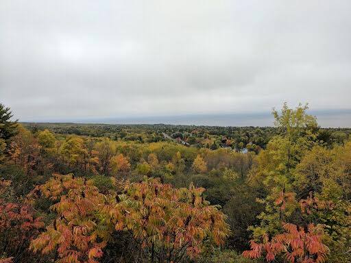
Thanks to Lee Huffman for this nice picture who is spending some time along MN's North Shore this weekend. Despite lingering clouds early Saturday, the weekend turned out to be a pretty decent.
Minnesota Fall Color Update
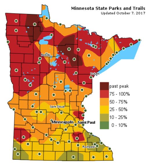
According the MN DNR, much of the state is starting to see hints of fall color, however, much of northern Minnesota is peaking right now with pockets of past peak colors!
Follow along as the fall colors change with the MN DNR map HERE:
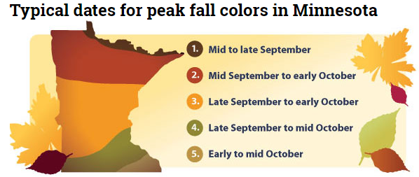
 Typical Fall Color Peak in Minnesota
Here are the typical fall color peak times across the state of Minnesota and note that areas along the northern tier of the state usually see their peak toward the 2nd half of September. However, peak color usually doesn't arrive in central Minnesota until October, but we're getting close.
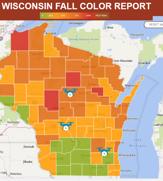
Wisconsin Fall Color Update
We're also seeing quite a bit of color show up across the northern half of Wisconsin with many locations now nearing 50%-100% color!
See more from Travel Wisconsin HERE:
____________________________________________________
Follow along as the fall colors change with the MN DNR map HERE:
Here are the typical fall color peak times across the state of Minnesota and note that areas along the northern tier of the state usually see their peak toward the 2nd half of September. However, peak color usually doesn't arrive in central Minnesota until October, but we're getting close.
Wisconsin Fall Color Update
We're also seeing quite a bit of color show up across the northern half of Wisconsin with many locations now nearing 50%-100% color!
See more from Travel Wisconsin HERE:

____________________________________________________
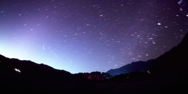
"There's going to be a beautiful meteor shower this weekend – here's when you need to look up"
"The Draconid meteor shower has been known to send 1,000 meteors an hour flying through the sky. Luckily for us countryside-dwellers, our cleaner and less light-polluted air means we stand a pretty good chance of being able to see meteor showers and lunar events when they occur – that's if the cloud decides not to make an appearance, of course. So, this weekend on 7th and 8th October, look up when the night sky rolls in and you should be in for a treat. The Draconid meteor shower will peak this weekend and send shooting stars across the sky between sunset and midnight. Seen from Northern America, Europe and Asia, the Draconids are debris from the comet 21P/Giacobini-Zinner, which is following its six and a half year orbit near Jupiter."
(Getty HIKO MIYAO via CountryLiving)
_______________________________________________________________
Tracking NATE in the Atlantic
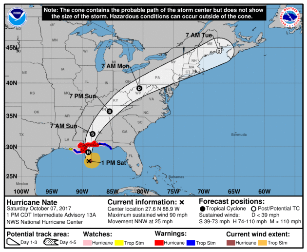
Here's a look at NATE from Saturday afternoon, which according to NOAA's NHC, was a category 1 hurricane with sustained winds of 90mph. Note that this is the fourteenth named storm and the ninth hurricane of the 2017 Atlantic Hurricane Season.
.gif)
Tracking NATE in the Atlantic
NATE will quickly weaken as it moves inland across the Gulf Coast States and into the Ohio/Tennessee Valley. Gusty winds and heavy rain will still be possible there through Sunday, but as the storm picks up speed, rain should be a little lighter across the Northeast.
Atlantic Outlook Next 5 Days
Here's the Atlantic outlook over the next 5 days, which shows NATE as it was near landfall along the Gulf Coast. There was also another wave of energy that had a HIGH probability of tropical formation over the next 5 days.
.png)
Watching The Tropics and the Southeast
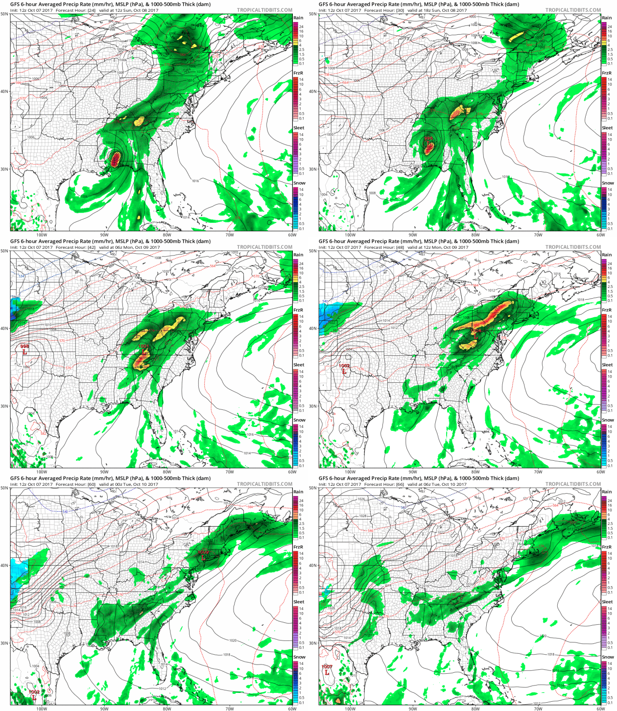
Here's the forecast from Sunday into early next week, which shows the remnants of NATE moving quickly to the Northeast with gusty winds and areas of heavy rainfall.
Heavy Rainfall Potential
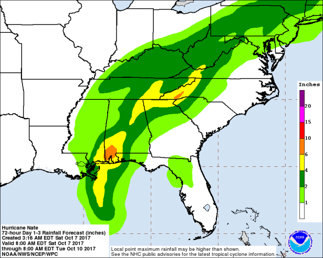
Here's the rainfall potential through Tuesday morning, which shows heavier rainfall potential across parts of the Gulf Coast States and into the Ohio/Tennessee Valley. Some areas to could see 2" to 4" with isolated 6"+ tallies.
__________________________________________________________
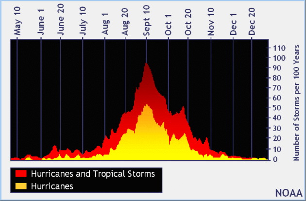
September 10th - Official Peak of the Atlantic Hurricane Season
Here's the average Atlantic hurricane season, which shows that peak activity generally occurs on September 10th and stays somewhat active through the month of October, but really diminishes through the month of November. Again, the Atlantic Hurricane Season doesn't officially end until November 30th.
PRELIMINARY 2017 Tornado Map
It certainly has been a fairly active first half of 2017 with 1392 preliminary tornado reports through October 6th. Note that this is the most tornadoes through that date since 2011, when there were 1,797 reports. The map below shows the distribution of the tornadoes so far this year.
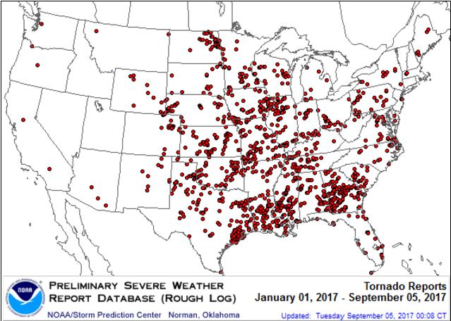 PRELIMINARY 2017 Tornado Count
According to NOAA's SPC, the PRELIMINARY 2017 tornado count is 1392 (through October 6th). Note that is the most active year for tornadoes since 2011, when there were 1,797 tornadoes. Keep in mind there was a major tornado outbreak in the Gulf Coast region from April 25-28, 2011 that spawned nearly 500 tornadoes, some of which were deadly. That outbreak is known as the Super Outbreak of 2011 and has gone down in history as one of the biggest, costliest and one of the deadliest tornado outbreaks in history.
_____________________________________________________________________
2.) Heavy snow across portions of Colorado, Mon, Oct 9.
3.) Flooding possible across portions of the Middle Mississippi Valley, the Upper Mississippi Valley, and the Northern Plains.
4.) Flooding occurring or imminent across portions of Florida and the Southern Plains.
5.) High winds across portions of the Central Great Basin and Northern California, Mon, Oct 9.
6.) High winds across portions of Southern California, Mon-Tue, Oct 9-Oct 10.
7.) High winds across southwest portions of mainland Alaska and the western Aleutians, Thu-Fri, Oct 12-Oct 13.
8.) High significant wave heights for coastal portions of the Aleutians, Thu-Fri, Oct 12-Oct 13.
9.) Slight risk of much below normal temperatures for portions of Northern California, the Central Great Basin, the Pacific Northwest, and the Northern Great Basin, Sat-Sun, Oct 14-Oct 15.
10.) Severe Drought across the Central Plains, the Northern Plains, Hawaii, the Northern Rockies, the Middle Mississippi Valley, and the Upper Mississippi Valley.
.png)
Latest Drought Monitor
Here's the latest drought update from the US Drought Monitor, which shows EXCEPTIONAL drought conditions continuing across parts of Montana. Note that nearly 90% of the state is considered to be abnormally dry, but the EXCEPTIONAL drought covers nearly 10% of the state, which is down from nearly 18% from last week. In North Dakota, less than 1% is in an EXCEPTIONAL drought, but nearly 3% of the state is still in an EXTREME drought, which is also the same as last week.
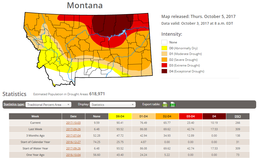
Rain Needed to End Drought
Thanks to recent cool and wetter weather, drought conditions have been improving, but we still need nearly 6" to 12" to end the drought in these locations.
____________________________________________________________________
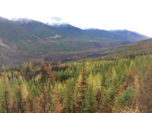
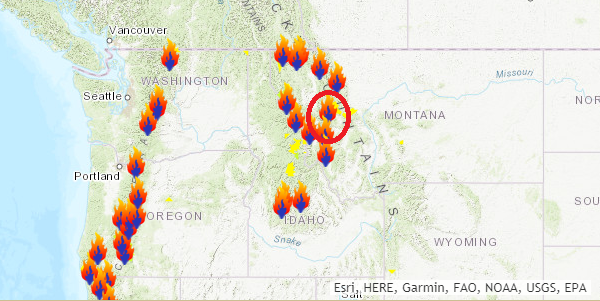
Rice Ridge Fire - 1.4 Miles NE of Seeley Lake, MT
The Rice Ridge Fire near Sleeley Lake, MT is another very large wildfire that started on Monday, July 24th due to lightning. The fire has grown to more than 160,000 acres and is 96% contained. There are 11 people working on the fire and they hope to have it fully contained by Sunday, October 15th.
"The Northern Rockies Wildland Fire Management Team is transitioning with the local Type 3 organization Tuesday Oct 3 at 6 p.m. Remaining operations will be managed by Phil Shilmerdine, Incident Commander. The Rice Ridge Fire was detected on July 24, 2017. It grew to the current size of over 160,000 acres. With a change of the weather and the onset of fall, fire activity has significantly slowed although firefighters and engines continue to patrol and cool hot spots that are near the fire's edge. The perimeter in the Scapegoat and Bob Marshall Wildernesses are continually monitored for heat and fire activity."
See more from inciweb HERE:
(Image Credit: Inciweb - taken on 10/3/2017)
 Ongoing Large Wildfires
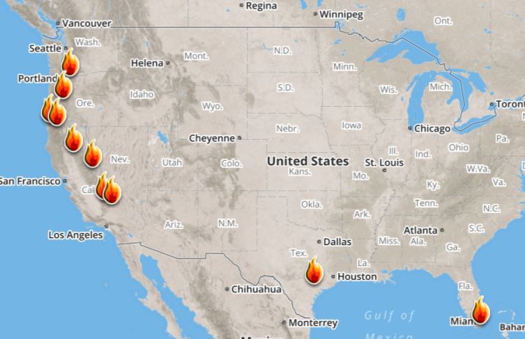
Here's a look at the current wildfire map across the country. While several fires are still ongoing, recent cool and somewhat wet weather has been helping curb the wildfire threat, especially in the Western US.
Here's a list of all the current large wildfires from Inciweb:
The Rice Ridge Fire near Sleeley Lake, MT is another very large wildfire that started on Monday, July 24th due to lightning. The fire has grown to more than 160,000 acres and is 96% contained. There are 11 people working on the fire and they hope to have it fully contained by Sunday, October 15th.
"The Northern Rockies Wildland Fire Management Team is transitioning with the local Type 3 organization Tuesday Oct 3 at 6 p.m. Remaining operations will be managed by Phil Shilmerdine, Incident Commander. The Rice Ridge Fire was detected on July 24, 2017. It grew to the current size of over 160,000 acres. With a change of the weather and the onset of fall, fire activity has significantly slowed although firefighters and engines continue to patrol and cool hot spots that are near the fire's edge. The perimeter in the Scapegoat and Bob Marshall Wildernesses are continually monitored for heat and fire activity."
See more from inciweb HERE:
(Image Credit: Inciweb - taken on 10/3/2017)

 Ongoing Large Wildfires
Here's a look at the current wildfire map across the country. While several fires are still ongoing, recent cool and somewhat wet weather has been helping curb the wildfire threat, especially in the Western US.
Here's a list of all the current large wildfires from Inciweb:
_________________________________________________________________________
National Weather Outlook
Here's the weather outlook through early next week, which shows wet weather across the eastern half of the country as the remnants of NATE move quickly northeast through the region. Areas of gusty winds and heavy rain will be found there, while another quick moving storm system rolls down the Rockies with snow expected in the high elevations and along the front range of the Rockies.
.gif)
5 Day Precipitation Outlook
According to NOAA's WPC, the next several days could produce very heavy rainfall across parts of the Eastern US and the Remnants of NATE move northeast through the region. Some locations could see 3" to 6"+ tallies, which could lead to localized areas of flooding.
.gif)
.png)
.gif)
Winter Storm Watch
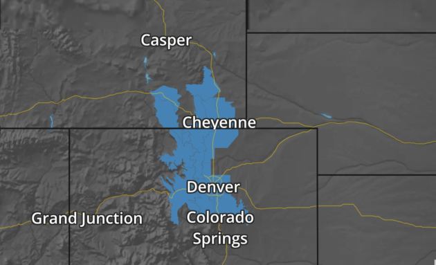
The National Weather Service has issued winter weather headlines from southeastern Wyoming to central Colorado as snow spreads into the region Sunday into Monday. Some locations along the I-25 corridor, including Cheyenne to Denver could see as much as 4" to 6"+.
Snowfall Potential
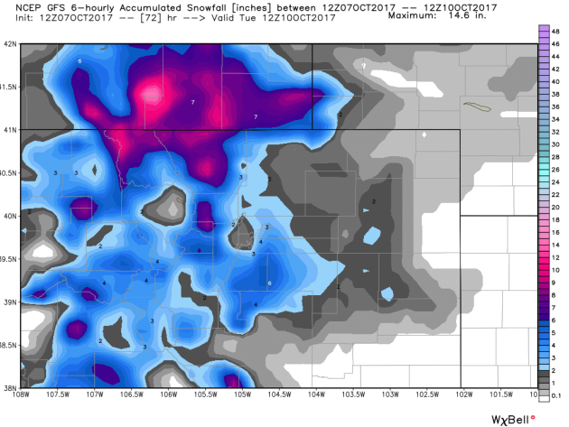
Here's a look at the snowfall potential through AM Tuesday, which suggests up to 6"+ of snow across the high elevations and even in the lower elevations along the I-25 cooridor, including Cheyenne and Denver.

Snowfall Potential
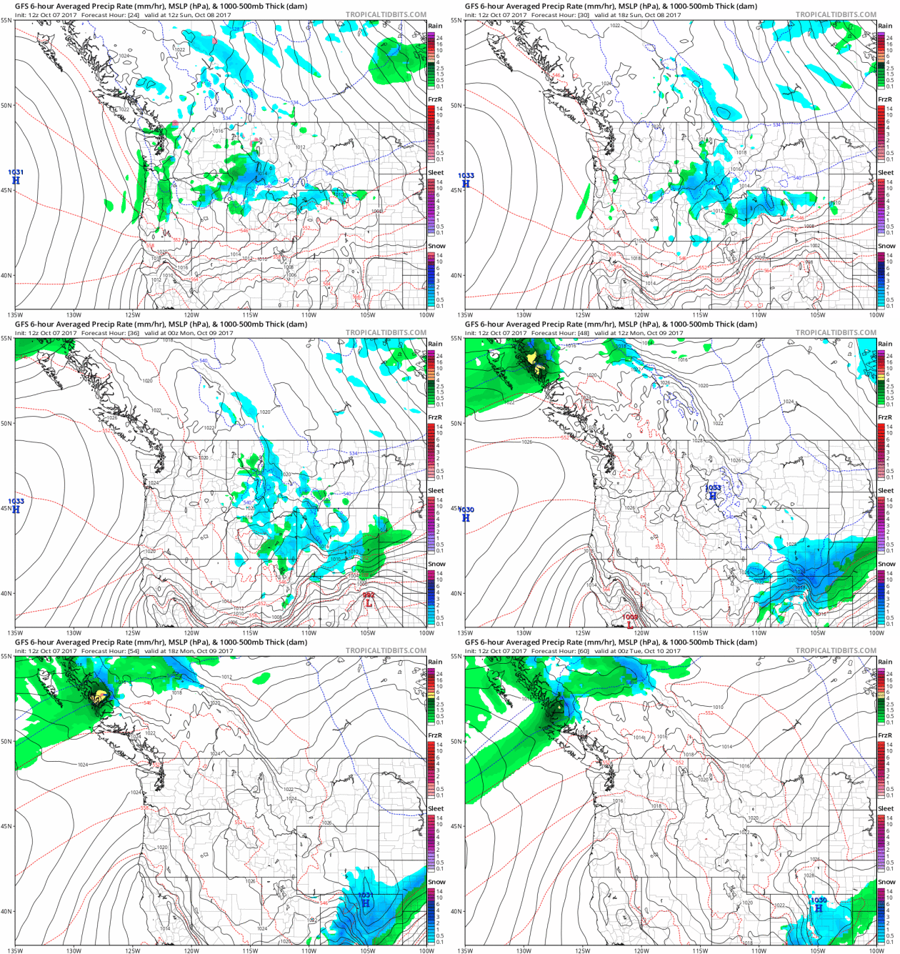
Storm systems will continue to push through the northwestern US with areas of moisture that will get wrapped in the higher elevations into snow.
.png)
Snowfall Potential
Here's the simulated radar from Sunday into early next week, which suggests areas of heavy snow sliding down the spine of the Rockies with accumulations up to 6"+.

________________________________________________________________________
More Sun - Fewer Puddles, but Wet Bias Continues
By Paul Douglas
By Paul Douglas
Are your drip-dries drooping? It's no wonder, considering 3-4 inches of rain has soaked the area since October 1. To put that into perspective, it's a month and a half worth of rain for the first week of the month.
Mea culpa: it's all my fault. You see, we're trying to do a little landscaping. Man plans - God laughs, right?
Nobody is laughing along the Gulf Coast; cities cleaning up from Hurricane Nate's landfall overnight. Not nearly the intensity or scale of an Irma or Maria, Nate is still capable of disruption and displacement, with flooding rains as far north as Pennsylvania this week.
Expect some mild sun Sunday with highs near 70F; a stray shower possible along the leading edge of cooler air later Sunday. A southern storm may brush Minnesota with rain showers Tuesday night and early Wednesday; a better chance of heavier/steadier rain next Sunday. No drought setting in anytime soon. No frost either for most of central and southern Minnesota. In spite of a few cold swipes October should wind up milder than average. Odds seem to favor another super-sized autumn this year.
________________________________________________________________________
________________________________________________________________________
Extended Forecast
SUNDAY: Some sun. Milder. Winds: NW 7-12. High: 70.
SUNDAY NIGHT: Partly cloudy and cool. Winds: NNW 5. Low: 45.
MONDAY: Mix of sun and clouds. Cool breeze. Winds: NW 8-13. High: 60.
TUESDAY: Fading sun, showers possible at night. Winds: NE 5-10. Wake-up: 39. High: 58.
WEDNESDAY: Showery start, then slow clearing. Winds: NE 5-10. Wake-up: 46. High: 63.
THURSDAY: Partly sunny. Lukewarm breeze. Winds: S 10-15. Wake-up: 54. High: 72.
FRIDAY: Intervals of sun, cooling off. Winds: W 8-13. Wake-up: 48. High: 62.
SATURDAY: Clouds increase, showers arrive late. E 7-12. Wake-up: 45. High: 61.
_______________________________________________________
This Day in Weather History
October 8th
October 8th
1949: A record-setting 3.17 inches of rain falls at Eau Claire.
________________________________________________________
________________________________________________________
Average High/Low for Minneapolis
October 8th
October 8th
Average High: 62F (Record: 87F set in 2010)
Average Low: 43F (Record: 23F set in 1876)
Average Low: 43F (Record: 23F set in 1876)
Record Rainfall: 1.43" set in 1970
Record Snowfall: 0.3" set in 1959
_________________________________________________________
Record Snowfall: 0.3" set in 1959
_________________________________________________________
Sunrise/Sunset Times for Minneapolis
October 8th
October 8th
Sunrise: 7:20am
Sunset: 6:40pm
Sunset: 6:40pm
Hours of Daylight: ~11 hours 20 mins
Daylight LOST since yesterday: ~3 minutes and 4 seconds
Daylight LOST since summer solstice (June 20th): 4 hours & 17 minutes
__________________________________________________________
Daylight LOST since summer solstice (June 20th): 4 hours & 17 minutes
__________________________________________________________
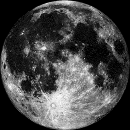
Moon Phase for October 7th at Midnight
3.2 Days Before First Quarter Moon
3.2 Days Before First Quarter Moon
_________________________
Weather Outlook For Sunday
Temps on Sunday will be very mild across the southern and southeastern part of the state as highs flirt with 70F. However, folks in northern Minnesota will only warm into the upper 50s, which will be closer to average there.
__________________________________________________________________________
Simulated Radar Ahead...
Here's the simulated radar across the Upper Midwest from Sunday into early next week, which suggests pretty quiet weather close to home as the wave of energy causing snow in the Mountain sails south of the region.
.gif)
______________________________________________________
Minneapolis Temperature Outlook
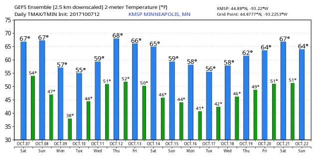
Here's the temperature outlook through October 22nd, which shows temps bouncing around the 50s and 60s. There may be a couple of days through the middle part of the month when the mercury flirts with 70F once again.
_________________________________________________________________
October Rainfall So Far...
It's been a fairly wet month so far with many areas seeing 1" to 2", but a few locations have seen 4" to near 5". It's been a months worth of rain through the first week of the month - WOW!
.png)
Minnesota Drought
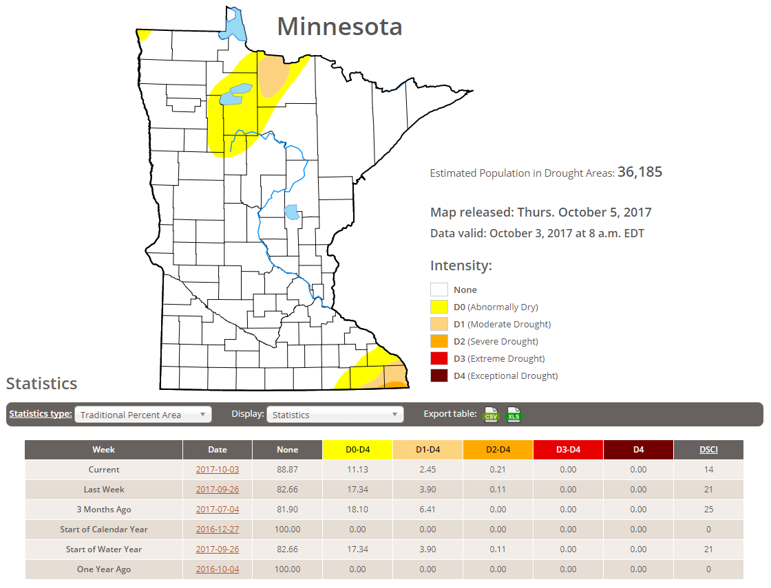
According to the US Drought Monitor, much of the state is drought free, but nearly 11% of the state is considered to be abnormally dry with 2.5% in a Moderate drought and less than 1% in a severe drought. Not bad.
_____________________________________________________________________
"Hurricanes batter payrolls: 33,000 jobs lost in Sept."
"Hurricanes Harvey and Irma significantly doused payroll growth in September as employers lost 33,000 jobs, but some other economic indicators have been positive and the weak showing is likely to be reversed in coming months. It marks the first time the economy has lost jobs since September 2010, but many analysts and Federal Reserve officials are likely to write off the disappointing performance. The unemployment rate, which is calculated from a different survey, fell to 4.2% from 4.4%, the Labor Department said Friday."
(Photo: Elise Amendola, AP Via USAToday)

_________________________________________________________________
"Hurricane Irma Means Your Orange Juice Could Soon Taste More Sour"
"That morning cup of orange juice could start to taste more tart. After Hurricane Irma wreaked havoc on Florida citrus crops last month, U.S. beverage companies could be forced to start using larger amounts of less-sweet Brazilian orange juice in their blends to make up for output losses. Brazil’s exports of orange juice to the U.S. may increase by as much as 50 percent to 300,000 metric tons, meeting the needs for about half of American consumption, Ibiapaba Netto, executive director at the juice exporters’ association Citrus BR, said in a telephone interview."
(Photographer: Daniel Acker/Bloomberg)
_______________________________________________________________________
"'Don't Let Your Guard Down': Atlantic Hurricane Season Isn't Over Yet"
"September was a doozy for hurricanes. By one measure, it was the most active month on record for the Atlantic Ocean, thanks, in particular, to two Category 5 monsters. But as the calendar has turned over into October, the Atlantic has gone quiet. This welcome respite from the tropical onslaught comes courtesy of a shift to less favorable conditions for storm formation, several experts said. But hurricane season is far from over, and the Atlantic Ocean is sure to see more activity, they warned. "We're not done yet," Phil Klotzbach, a hurricane researcher at Colorado State University, told Live Science. August, September and October mark the climatological peak of the Atlantic hurricane season, which stretches from the beginning of June to the end of November. That means those months, particularly September, tend to be when most of the hurricane action happens. This September "was like peak season on steroids," Klotzbach said."
(NOAA GOES-16 satellite captured this image of Hurricane Maria as it made landfall on the Caribbean island of Dominica on Monday evening (Sept. 18). Credit: NOAA)
___________________________________________________________
"How Evaporation from Lakes and Reservoirs Could Sustainably Power a Nation"
"When we think of renewable energy sources that could help replace the burning of climate-altering carbon-based fuels, solar panels and wind turbines come to mind. But Columbia University scientists have identified another, thus-far untapped energy source that might have just as much promise — the massive amount of water that continually evaporates from the nation's lakes and reservoirs. That natural phenomenon, they say, could be tapped into by devices containing sheets covered with bacterial spores, which contract and expand in response to changes of moisture — almost like the flexing of a muscle. That mechanical "muscle" action, in turn, could be used to generate gigantic amounts of electricity, they say. In a newly published article in the journal Nature Communications, the researchers estimate that inland bodies of water in the United States have at least the theoretical potential to generate as much as 325 gigawatts of electricity, an amount equals to nearly 70 percent of our nationwide electrical consumption in 2015."
(JUAN CARLOS MUNOZ/GETTY IMAGES via How Stuff Works)

_______________________________________________________________________
"That Giant Antarctic Iceberg Just Revealed an Ecosystem Hidden For Thousands of Years"
"When a vast trillion-tonne chunk of ice the size of Delaware broke free from Antarctica in July, it didn't just set loose one of the largest icebergs scientists have ever witnessed. The massive calving also uncovered a mysterious and precious marine ecosystem hidden under the ice that could have been buried for up to 120,000 years – and it's vital we protect this isolated sanctuary now it's been laid bare. "I cannot imagine a more dramatic shift in environmental conditions in any ecosystem on Earth," marine ecologist Julian Gutt from the Alfred Wegener Institute for Polar and Marine Research in Germany told Nature. That epic transition is due to the iceberg – which is called A–68 – drifting and disintegrating northwards into the Weddell Sea and away from its former moorings, the Larsen C ice shelf."
(Copernicus Sentinel–1/BAS via Sience Alert)

_____________________________________________________________________
"Tropical volcanoes can lead to El Niño events"
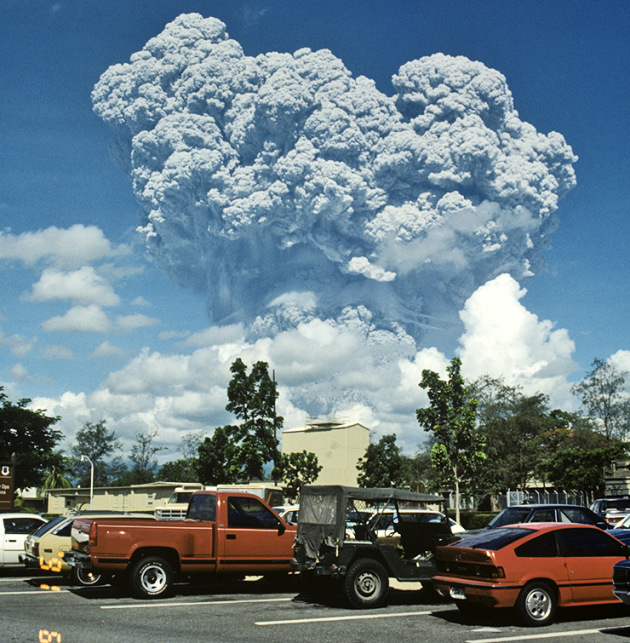
"Volcanic eruptions that occur in the tropics can cause El Niño events, warming periods in the Pacific Ocean with dramatic global impacts on the climate, according to new research. Enormous eruptions trigger El Niño events by pumping millions of tons of sulfur dioxide into the stratosphere, which form a sulfuric acid cloud, reflecting solar radiation and reducing the average global surface temperature, according to the study. The study used sophisticated climate model simulations to show that El Niño tends to peak during the year after large volcanic eruptions like the one at Mount Pinatubo in the Philippines in 1991. “We can’t predict volcanic eruptions, but when the next one happens, we’ll be able to do a much better job predicting the next several seasons, and before Pinatubo we really had no idea,” says Alan Robock, coauthor of the study and a professor in the environmental sciences department at Rutgers University-New Brunswick. “All we need is one number—how much sulfur dioxide goes into the stratosphere—and you can measure it with satellites the day after an eruption.”
(Credit: US Geological Survey via Rutgers)
_________________________________________________________________________

No comments:
Post a Comment