Tornado Watch. SPC has issued a new watch (meaning conditions are ripe for isolated tornadoes) effective until 10 pm Tuesday night - including Breckenridge, Wheaton, Moorhead and Thief River Falls. Storms should weaken later tonight, sweeping across northern and central MN (St. Cloud stands a better chance of strong storms/downpours than the Twin Cities later tonight).
Tornado Threat. SPC has extended the "slight risk" of severe storms east, including the Twin Cities and most of Minnesota. There is a 10% probability of an EF2-5 tornado within 25 miles of any location in far northwestern/west central MN, mainly during the evening hours, when the atmosphere will be most unstable. The area of concern is from Moorhead, Detroit Lakes and Fergus Falls northward to near Thief River Falls and Crookston. Stay tuned for more updates throughout the afternoon - the greatest potential for tornadic "supercell" T-storms will come during the day Wednesday, when dew points are forecast to peak around 76 F in the metro area (extremely tropical air) with sufficient wind shear and instability to support a widespread severe storm outbreak).

Growing Tornado Bulls eye? This is the prediction of EHI, the energy helicity index, which factors in wind shear and instability into one index. The forecast is valid around the dinner hour Wednesday. The highest values can be found across southern MN and Iowa, where the atmosphere is forecast to become explosively unstable Wednesday afternoon/evening. There may be enough variation in wind speed/direction to create long-lasting, rotating "supercell" thunderstorms capable of large hail, even a few isolated tornadoes tomorrow afternoon. My hunch: SPC will issue a tornado watch encompassing much of central and southern MN, and there will be a handful of tornadoes.

 Monday Miracle. This is the first time I can recall seeing this all summer: no rain at any reporting station in Minnesota, highs fairly uniform, ranging from 75 at Alexandria to 80 at Crystal (northwest suburb of Minneapolis).
Have we had a bad Monday yet far this summer? I doubt it. Mondays always seem to be sunny and nearly trouble-free, and today was no exception, with morning clouds giving way to blue sky and low humidity. Dew points dipped into the 40s and low 50s as much drier air leaked south out of Canada, a welcome respite from the thick humidity of last weekend. I must be mad - I spent most of yesterday evening sitting out on the deck, watching the setting sun, reading a barbell of a book, Stephen Kings "Under The Dome", which weighs in at 5 pounds and 1074 pages. Not so much of a novel as a workout. That's how I want to remember the summer, sitting under a molten sun, reading (for pleasure) and temporarily putting the cares and worries of the day into a drawer. I know, easier said than done.
 Reverse Lake Effect. Here is NASA's ultra-high-res visible satellite image taken midday Monday, showing a lack of clouds over lakes across Minnesota and Wisconsin. The reason? Lake water temperatures are relatively cool (50s over Lake Superior to 70s from Leech to Mille Lacs). In contrast surrounding land areas are warmer by 10-15 degrees, sparking thermals of warm, rising air and subsequent "popcorn" cumulus clouds. It's the reverse of what happens in the late fall and early winter months, when lakes are warmer than surrounding land masses, sparking clouds and showers of rain/snow downwind, especially over the larger Great Lakes, where the "fetch" of wind over the lake is long enough to spark precipitation. The latest MODIS image can be found here.
* Great Lake Warms Up. The top waters of Lake Superior just reached an average temperature of 59 F, more than one month ahead of schedule. The story in the Star Tribune is here.
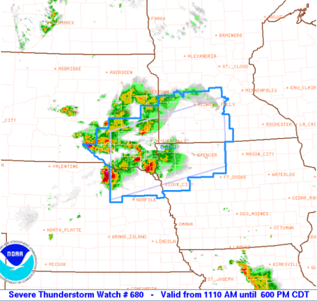
 Severe Threat. Strong/severe storms will bubble up over the Dakotas later today, reaching far western Minnesota by the dinner hour, some capable of large, damaging hail, straight-line winds even an isolated tornado. Storms may still be at or near severe levels by the time they reach the St. Cloud area after 8 pm. The very latest from SPC (Storm Prediction Center) can be found here.
Wednesday looks ripe for trouble, so much so that we're sending one of our brave WeatherNation interns out to chase tornadic "supercell" storms - equipped with an HD camera, wireless card and laptop. That's how nasty we think Wednesday may be - most of the ingredients necessary to whip up tornadoes probably present nearby: unusually strong low-level jet stream winds (as high as 30-50 mph. in the lowest few thousand feet of the atmosphere), ample low-level moisture (dew points near 70) and explosive instability. If the sun is out for a few hours during the midday and early afternoon hours Wednesday (a distinct possibility) then severe weather is almost a sure thing. The big question: will Tuesday night/Wednesday morning T-storms stabilize the atmosphere and push the main threat south/east of Minnesota (possible, but doubtful). If clouds linger much of the day warm, rising thermals of juicy air may not be able to break through the "cap", an inversion of warming air a few thousand feet aloft. There are no guarantees (there never are) but I'm sufficiently paranoid about Wednesday that I'm going out on a (shaky) limb, predicting a minimum of 3-6 tornadoes - best chance south of the Minnesota River. I hope I'm wrong - but I fear that a witch's brew of ingredients may converge directly overhead Wednesday afternoon and evening. Plan on watches and warnings, have a Plan B and C after lunchtime on Wednesday, and be pleasantly surprised if tornadic storms don't materialize.
We hang on to a blue sky much of today, gusty south winds by afternoon pumping stickier air back into Minnesota, late afternoon temperatures reaching the mid 80s as high (cirrus) clouds dim the sun. There's a slight risk of severe storms sweeping into far western Minnesota later this afternoon and evening, possibly forming an MCS system (mesoscale convective system) tonight as it weakens over central and eastern MN, capable of frequent lightning and torrential rains. There's a good chance we'll get off to a soggy start Wednesday morning, but I expect the sun to peek through by midday, setting the stage for a potentially widespread severe storm outbreak later Wednesday, possibly the biggest outbreak since June 17, when over two dozen tornadoes touched down on Minnesota, the second greatest outbreak in Minnesota history. We'll see, but I have a pretty bad feeling about tomorrow.
Skies clear Thursday, sunshine the rule Thursday through Saturday, which (right now) looks like the sunnier day of the weekend. Right on cue, right on schedule, here comes another noisy front Saturday night and Sunday, another outbreak of T-storms likely. Best chance of being chased indoors by churning black clouds? Saturday night, again Sunday afternoon.
We're due for a little real heat, a spell of sweltering, sweaty weather, a string of 90s. The GFS is hinting at 4-5 days in a row above 90 the latter half of next week, and frankly, I wouldn't be one bit surprised. Historically, Minnesota's hottest weather comes 3-4 weeks AFTER the summer solstice, usually in mid or late July. We've had only 4 days above 90 (typical summer brings 13 or 14 days at or above 90). We're due. Stay tuned, and check in often over the next 24 hours as we try to pin down which counties in Minnesota may see the worst of Wednesday's severe storm outbreak (my hunch is Mankato to Rochester, but this could change, depending on a myriad of factors).
If severe (tornadic) storms do develop Wednesday afternoon we'll be tracking them right here at startribune.com - making it easy to check in on your computer from work or home. I have a hunch the Doppler is going to be smoking within 24-36 hours.
 A Hint of Real Heat? The GFS model is suggesting 4-5 days in a row above 90 the latter half of next week. We're due, and it's coming at the right time (our hottest weather of the entire year often comes during the second, third or fourth week of July).
 Full Moon Over Minneapolis. Click here for a photogenic timelapse of the recent full moon over the Twin Cities, courtesy of Brian Stuckey and Vimeo.
 Fewer Tornado Deaths in 2010. Kansas.com has an interesting article about the relatively low number of Americans that have been killed by tornadoes so far this year. Luck? Doppler radar? More professional storm spotters? Perhaps a combination of all three. The article is here.
 Shelf Cloud - Belgian Style. America sees more severe storms than any other nation on Earth, but we certainly aren't the only ones capable of seeing rough T-storms capable of strong, straight-line winds, like the squall line that raged across Brussels, Belgium last weekend. The video timelapse is here.
 Images BP Doesn't Want You To See. The Atlantic has the story, and a series of disturbing photos here.
Climate Stories
 Earth From Space: Greenland Glacier Shrinks Overnight. Between July 6-7 a 2.7 square mile chunk of a Greenland glacier broke off, roughly 1/8th the size of Manhattan Island. The story at Wired News is here.
* Scientists Find Rising Carbon Dioxide And Acidified Waters in Puget Sound. Click here to read the full text of the story from NOAA.
* Hawaii is Already Feeling The Effects of Global Warming, Experts Say. The story is here.
* If You Can't Stand the Heat, You Won't Like This Study. The article is here.
* We Fiddle, While the Farm Belt Copes With Climate Change. Most farmers will tell you that something has changed, the rainfall and temperature patterns have changed in recent years, not as reliable (or predictable) as they were for much of the 20th century. The story at chron.com is here.
Paul's Conservation MN Outlook for the Twin Cities and all of Minnesota
Today: Plenty of sun, warmer, more humid than yesterday. Severe storms push into far western MN by late afternoon or evening. Winds: S/SE 15-25. High: 84
Tuesday night: T-storms arrive, some packing heavy rain and frequent lightning. Low: 71
Wednesday: Muggy and unsettled with intervals of sun, a few severe storms are likely by late afternoon, with a significant risk of large hail, damaging winds, even a few tornadoes. High: 83
Thursday: Getting sunnier, drying out statewide. High: 86
Friday: Blue sky, plenty warm. High: 88
Saturday: Probably the sunnier day of the weekend - partly sunny, windy and humid. High: 89
Sunday: Less sun, a few scattered T-storms likely. Sticky. High: near 90
Monday: Partly sunny, an isolated T-shower possible by late afternoon. High: 86
No comments:
Post a Comment