
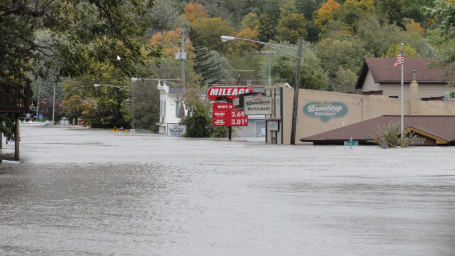
Zumbro Falls. Friday I ventured into southern Minnesota to get a first-hand look at the flooding. It isn't often that I-35 is closed due to flooding, that's a rather extraordinary event. We went down Highway 52, but that was closed south of Zumbrota, so we made our way east through Mazeppa to Zumbro Falls, managed to talk our way around 2 roadblocks, and came back with some amazing photos of the flooding. The locals we talked to were still in shock, gathering in small clusters, shaking their heads in disbelief. "This looks like the aftermath of a hurricane," one long-time resident remarked, pointing to her home, or what was visible above the murky water (just the roofline).
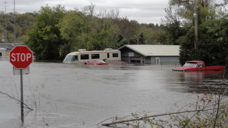
Evacuation. The entire town of Zumbro Falls had to be evacuated, one of a handful of towns fighting back the raging waters of the Zumbro River. One resident told me that this will, in all probability, be worse than the Flood of '51, the previous high water mark. In fact the Zumbro River is forecast to crest a full 5 feet higher than it did in 1951, according to river forecasters.
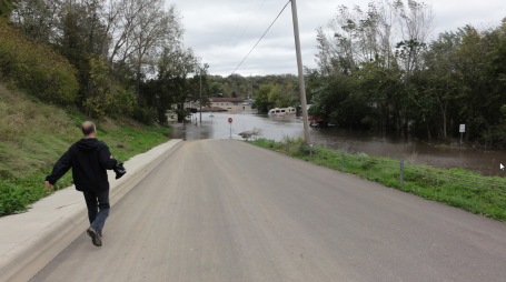
Racing To The Scene. My thanks to friend and photojournalist John Overby, who has worked at Channels 9, 11 and 29 here in the Twin Cities - for accompanying me to the scene of some truly heart-breaking flooding. Everywhere you turned there was water - it seemed like the entire town was submerged.
Shoulder Shrugging. Everyone kept asking, "how could this happen - in late September?" I explained the meteorology involved, but it didn't seem to satisfy anyone. Very slow-moving storm, a stalled warm frontal boundary, a "train-echo" effect with T-storms forming and re-forming for the better part of 18 hours. "I could understand this better in the spring, after snow melt or even in June," one resident muttered. "But the first full day of autumn? That's just weird."
Agreed. A true meteorological head-scratcher.
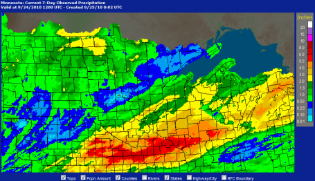
* Minnesota State Climate Office records: 5 major floods in Minnesota since 2002.
* Thursday's storm: 2-3 month's worth of rain for much of southern Minnesota - thousands of square miles were inundated with at least 6" or more of rain. According to the State Climate Office it was the biggest storm to strike southern MN since August 18-20, 2007 - very similar to a storm that drenched southern counties Sept. 14-15, 2004. More from the Climate Office here.
* Standing water in fields along the I-90 corridor: harvest delayed 1, possibly 2 weeks - water damage may affect yields.
* 10.7" at Amboy, Minnesota, 11th most significant single-storm rainfall amount in modern-day history.
* All-time 24 hour rainfall record: 15.1" at Hokah, Minnesota on August 19, 2007. It was the most rain from a single storm for the following towns: Amboy, Waseca, Springfield, Zumbrota and Faribault. More perspective from the NWS here.
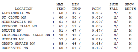
Hellooo October. We got an early taste of October Friday, temperatures more typical of the October 8-13. The "high" was only 48 at International Falls (where 2.27" of rain fell in the last 24 hours), 51 at Duluth and 53 at Hibbing. With skies clearing from west to east the mercury finally struggled to 60 at St. Cloud, 61 in the Twin Cities. The normal high for September 24: 68 (last year it was 78).
Paul's Conservation MN Outlook for the Twin Cities and all of Minnesota
Today: Morning sun, PM clouds, passing shower or sprinkle (most of the day should be dry). Winds: E 8-13. High: 59
Saturday night: Clearing and chilly - a light frost possible over central and northern MN. Low: 42
Sunday: Nicer day, more sun, fewer clouds - odds favor a dry, pleasant fall day. Winds: S 10-15. High: 66
Monday: Even better, bright sun with lukewarm afternoon readings. High: near 70
Tuesday: Bright sun, too nice to be cooped up inside. High: 74
Wednesday: Sun dimmed by high clouds as a slightly-cooler front approaches. High: 71
Thursday: Plenty of sun, a few degrees cooler - still very nice. High: 69
Friday: Still complaint-free, lot's of sun, a cooler breeze. High: 64
Have you dried out yet? What a crazy week. Monday starts out foggy and drizzly, but the sun comes out in the afternoon with a high temperature of 80 (close to midnight!) - followed by a round of nocturnal T-storms late Monday night. We get a little break Tuesday, only to be beseiged by severe thunderstorms over southern Minnesota Wednesday, storms which stall out near the Iowa border, resulting in some hurricane-like rainfall accumulations by Thursday evening, and for some towns in southern Minnesota, the worst flooding in 60 years.
The storm is long-gone now, but a wrinkle of chilly air aloft may destabilize our sky enough to spark a few scattered showers and sprinkles this afternoon, temperatures holding in the 50s to near 60, about 10 degrees cooler than average. Even if it does rain at your house it WILL NOT be an all-day rain, maybe 20-40 minutes of showers after lunchtime.
Now for the good news: A weak bubble of high pressure drifts overhead Sunday, treating us to blue sky and highs in the upper 60s to near 70 (close to average - where we SHOULD be in late September). And the models all seem to pretty much agree: 1-2 weeks of dry weather IN A ROW! That's right, any major storms should pass well south of Minnesota through the first week of October - I don't see significant rain until possibly mid October. That's great news for all of us, but especially Minnesota's farming community. A lot of farmers are staring out their windows at standing water in their fields - there is no question the harvest will be delayed by muddy conditions for at least a week, possibly 2 in parts of southern Minnesota - it's still unknown how big an impact the floods will have on the harvest.
Welcome to the Land of All or Nothing. Either we have a hurricane's worth of rain in 24 hours, or a dry, sunny spell that lingers for 2 weeks.
Never a dull moment. Enjoy the weekend - today will be so-so, but Sunday will have been worth the wait, and next week will be classic September weather, coming a little bit late - but better late than never, I guess.
"Nicole?" Long-range models are still trying to spin up a tropical storm - even a minimal hurricane over the Gulf of Mexico by next weekend. Not convinced - we'll see.
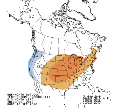
Something To Look Forward To? Remember, weather is cyclical - unusually cool/wet spells are USUALLY followed by episodes of milder/drier weather. The ying and the yang of weather - the atmosphere always trying to get to a state of equilibrium. I wish I could get to a state of equilibrium, come to think of it. The Climate Prediction Center long-range forecasters are pretty convinced we'll enjoy a warmer than average October. Although I tend to shun long-range weather predictions (about as accurate as a 1-month prediction of the stock market) I think they're right. September will wind up 2-3 degrees F. cooler than average across much of the state - we are DUE for a temperature rally! More from CPC here.

"Indoor Clouds". Do you have a weather fetish - and entirely too much cash burning a hole in your pocket? For an outrageous sum a company called "Transsolar" will be happy to generate real clouds inside your house or office. It requires special machinery pumping in air at different temperatures and humidity levels, and voila! You own personal cloud. File this under bizarre.

Fighting Off A Bear With A Zucchini. Attacked by a random bear in the woods. Consider doing what this woman did in Montana. When a bear attacker her dog and bit her in the leg she threw a zucchini at the bear - causing it to flee. Hey, if someone hurled a zucchini at me I'd hit the road too!
The Evolving Great Lakes. Winters are trending warmer over the Great Lakes - less ice, leaving more open water (which in turn creates more lake effect snows downwind). Winters have become cloudier, wetter and more humid, and there's concern that long-term trends favor falling water levels from Superior to Ontario. More on new studies focusing on the Great Lakes here.
The Perils Of A Decomposing Permafrost. Florida State researchers are studying the thawing permafrost region of Sweden, trying to understand more about "positive feedback", sometimes called feedback loops. As the arctic region continues to warm, melting permafrost releases methane, a greenhouse gas 21 times more potent than carbon dioxide. All this methane causes further warming, which melts more permafrost, released more methane, etc - an endless loop of potential trouble. What does in mean - and what (if anything) can we do to stop these feedback loops. Some answers here.
No comments:
Post a Comment