Winnebago (Faribault County): 11.06"
Amboy (Blue Earth County): 10.68"
Truman (Martin County): 10.2"
Windom (Cottonwood County): 9.26"
Theilman (Wabasha County): 8:57"
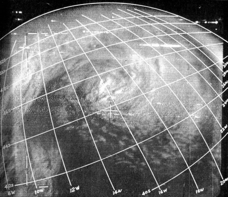
Before Picture. This is one of the first images received from the low-orbiting "Tiros-1" weather satellite, launching in 1961. If you look carefully (squint) you can make out what vaguely looks like a storm near the center of the screen. Scientists were absolutely AMAZED by these first grainy, black and white images. We thought Tiros-1 was a pretty big deal! Before weather satellites hurricane forecasters had to rely on SHIPS to have any idea where hurricanes and tropical storms were lurking. It was nothing short of a revolution in meteorology - and we've come a long way in 50 years.
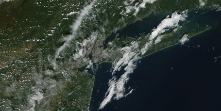
After Picture. Here is Saturday's "MODIS" 250 meter image taken from the low-orbiting "Terra" satellite operated by NASA. Minnesota was cloud-cluttered - so I chose to zoom in on New York City - amazing resolution - you can actually make out individual cumulus clouds, which are a few hundred yards wide. The detail is nothing short of extraordinary. Click here to see today's image, courtesy of the University of Wisconsin (updates around midday).
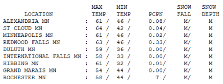
No Weather Awards. It was a pretty blah Saturday, gray much of the day, a couple hours of rain around the breakfast hour in the metro area, but at least it brightened up late in the day. Rainfall amounts ranged from nothing in Duluth to .02" in the Twin Cities, .04" at St. Cloud and a sloppy .33" at Redwood Falls, courtesy of an "upper air disturbance", a wrinkle of unusually cold air aloft pinwheeling across the state - that puddle of chilly air 3-6 miles overhead is pushing south/east - and a warming trend aloft should mean plenty of sun today, in fact MOST OF THE WEEK WILL BE SUNNY! So sunny and nice that I relapsed into typing WITH ALL CAPS!! Stop shouting Paul - we get the idea!!
Paul's Conservation Minnesota Outlook for the Twin Cities and all of Minnesota
Today: Foggy start in some neighborhoods. Fog burns off with plenty of midday/afternoon sunshine. Winds: S 7-12. High: 65
Sunday night: Mostly clear - more patchy fog, especially river valleys. Low: 48
Monday: Blue sky, lukewarm afternoon breeze - very nice! High: 68
Tuesday: Mostly sunny and warmer - above average for a change. High: near 70
Wednesday: Warm sunshine - distractingly nice. High: 75
Thursday: On a roll - more sunshine. High: 72
Friday: Not even close to being sick of the sunshine. High: 74
Saturday: Blue sky - nice way to kick off October. High: 71
This will be the shortest weather blog I've ever written, for several good reasons (at least I think they're valid reasons/excuses). #1). I'm tired. I know - "wahhhhh. So what. We're all tired." Just being honest. I spent the day with some friends - flew down to South Bend to take in a Notre Dame football game (they lost to Stanford). When someone invites you to see Notre Dame you should probably say yes, even if you don't bleed green and yellow. I'm pretty friend. Let's just leave it at that. A little too much wind chill and lake effect.
Excuse #2). There's no weather in sight. The GFS prints out .01" over the next 16 days, and I think the .01" predicted for Tuesday is a computer hiccup. I don't seen any significant rain looking out 2 weeks. We're about to make up for a September which is running twice as wet as normal for the Twin Cities, but as much as 4-5 times wetter than average for some counties in southern Minnesota.
It's payback time....the weather we SHOULD have seen in mid September will now decorate our sky the last few days of September, with an unseasonably mild, quiet first half of October. We're talking highs in the mid 60s to mid 70s into MUCH OF NEXT WEEK! Enough with the caps, Paul. It's getting tiresome. Sorry.
I'm happy to be able to unplug the Doppler, kick back and enjoy a spell of weather more typical of Palm Springs in November - low humidity, blue sky, cool, bracing mornings giving way to lukewarm afternoons, warm enough to ensure that your kids will probably forget to bring their jackets home each day. A nice problem to have.
Only one (small) fly in the weather ointment: fog. Under a ridge of high pressure winds will be light the next couple of mornings. After Saturday's light rain the lowest few hundred feet of the atmosphere is still quite moist, nights long enough now for the temperature to drop to the dew point, "saturating" the air overhead, resulting in a relative humidity of 100% and lazy clouds forming on the ground - fog. It may be quite dense in some areas. If the fog lingers shave 5 degrees off today's predicted high of 65 in the metro area.
Other than that - smooth sailing through at least October 12. It isn't often we can predict "storm-free" for a 2 week stretch. Finally, some good news for farmers anxious to get out into their waterlogged fields and get serious about the harvest. Mold is starting to grow on my northern side - happy we can all get a break from Mother Nature for a few weeks in a row. Soak it up.

No comments:
Post a Comment