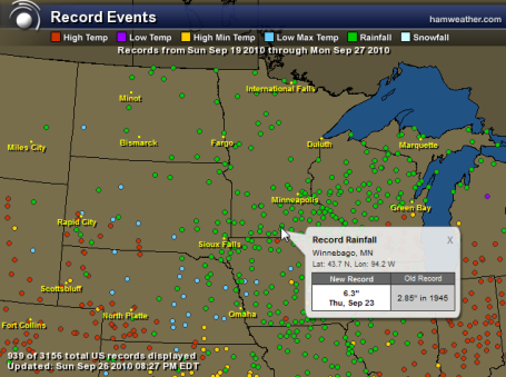
September Rainfall in the Twin Cities:
Normal: 2.40"
Actual: 5.51" (it has rained on 14 of the last 28 days in the Twin Cities).


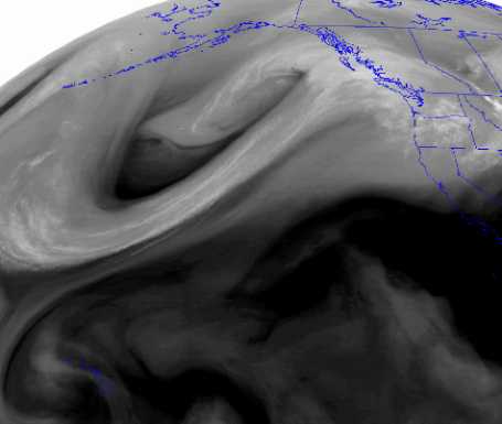
Flash Floods. Monday was an odd day, torrential rains along the east coast of the USA, flooding rains - even a few isolated tornadoes racing northward across Virginia and Maryland - in late September?


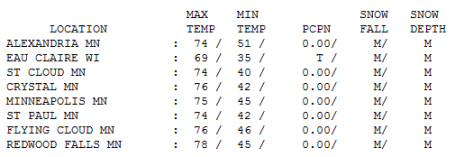
Monday Memories. In spite of a weak cool frontal passage the atmosphere floating overhead yesterday was "well-mixed", allowing air from 6,000 to 8,000 feet above the ground to reach the ground, boosting the mercury to 74 in St. Cloud, 75 in the Twin Cities and a balmy 78 at Redwood Falls, 8-10 degrees warmer than average for September 27.
Paul's Conservation MN Outlook for the Twin Cities and all of Minnesota
Today: Bright sun, breezy and a bit cooler. Winds: N 8-13. High: 64
Tuesday night: Clear and cool. Low: 51
Wednesday: Partly sunny and milder - slight chance of a shower over northern and central MN. High: 71
Thursday: Breezy and cooler again with plenty of sunshine. High: 67
Friday: Blue sky - still extraordinary. High: 65
Saturday: High pressure overhead - sunny with light winds. High: 62
Sunday: Sunny and milder - another perfect fall day. High: near 70
Monday: More of the same - lot's of sunshine, pleasantly mild. High: 73
I am at a rare (and welcome) loss for words. Monday was spectacular, in spite of some patchy clouds from a weak frontal passage (which actually kicked up a few T-storms over the MN Arrowhead). A transfusion of slightly cooler, drier air will surge into Minnesota today on northerly breezes, highs about 5-7 degrees cooler than yesterday, but I expect few complaints.
That will be the weather story looking out through most of next week, possibly through the second week of October - unusually dry, quiet and lukewarm. A "split flow" in the jet stream will cause storms to detour well south (and north) of Minnesota, keeping us in a miraculously quiet, storm-free oasis of high pressure. Every now and then a gently-used frontal boundary will come limping through town, but moisture will be very limited over the next 2 weeks, and I still don't see any significant rain looking out through October 14, give or take.
This is coming at a very good time for weather-weary farmers, many still staring out their windows at standing water in their fields. They desparately need a spell of unusually dry weather, and right on cue: here it is. If you need an extended stretch of sunshiny days for construction, yard-work, closing up the cabin (too early), taking out the dock, winterizing your yard (too early) or getting out into your waterlogged fields, you're in luck!
A weak clipper-like system may spark a stray shower or two over the northern third of Minnesota tomorrow - this wind shift line will probably come through dry in the Twin Cities, only a very slight chance of a 20 minute shower or T-shower from St. Cloud to Brainerd and Duluth. We warm up into the low 70s tomorrow, cool down in the low/mid 60s Thursday and Friday - a little frost up north Saturday morning may give way to 70+ F. again by Sunday and Monday of next week. More like San Diego or Palm Springs than a classic early October in MInnesota.
Not complaining one bit - not sure if this is payback for an unusually wet and stormy September (and a wild summer for that matter) or a prequel to a wild and stormy late Autumn; whatever the meteorological trigger I'm giving thanks for 2 of the nicest weeks you'll ever find at this latitude in late September and the first HALF of October.
Time to unplug the Doppler. That doesn't happen very often.
Nicole? Check out the swirl of low pressure west of Florida by Sunday evening. NHC forecasters in Miami are keeping an eye on an area of disturbed, thundery weather south of Cuba. it's forecast to drift north, and possibly strengthen over warm tropical waters later this week. It's still too early to know if there is a real tropical storm/hurricane risk in the Gulf of Mexico or Florida. So far this year the USA has been extraordinarily lucky - 13 named storms and no direct hits.

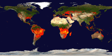
Fire Threat. In all at least 22 regions of Russia endured record wildfires during the intensely hot and dry summer of 2010. NASA scientists can track these fires in realtime. Surprisingly a small number of these brushfires are sparked by natural causes, like cloud to ground lightning strikes. An estimated 90% of these "biomass burnings" (burning of living or dead plant materials) are man-made. A warmer world will increase evaporation (and the frequency/intensity of extreme rainfall amounts) but this heightened evaporation will dry out much of the planet, creating ripe conditions for wildfires to develop and spread. More from NASA on a growing fire threat here.

No comments:
Post a Comment