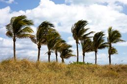
Last 70-Degree Day Of 2010? We've had a remarkable run, today is the 27th day in a row without measurable rain. The fire danger is "extremely high" across most of Minnesota - stating the obvious: it's tinder-dry out there. The sun should be out most of today, predicted highs in the 65-70 F. range, 14 degrees above average for October 22. BTW, a high of 70 is the average high for September 15!
*
October 2010: 5th warmest on record for the Twin Cities, temperatures running 6.3 F. warmer than average.

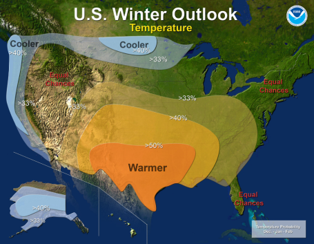 Winter Outlook From NOAA.
 La NIna is strengthening in the Pacific, a cold phase which correlates with cooler than normal winters for Minnesota and the Upper Midwest. But every La Nina is different - there are no guarantees that we'll have a harsher-than-usual winter, but statistically - odds seem to favor that we may be grappling with a litlte more wind chill than we've seen in recent winters. I
sure hope this outlook for November - January is WRONG!
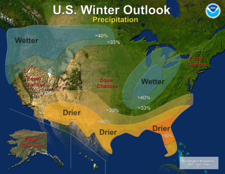 Winter Precipitation
. More snow than average is predicted from the Pacific Northwest into the Dakotas, as well as the Ohio Valley, La Nina favoring a drier-than-normal winter for the Deep South. We'll see. The NWS has more details
here.
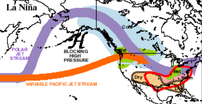 La Nina Pattern
. Prevailing jet stream winds this winter will favor a massive ridge of high pressure over western Canada, which may focus a norhtwesterly wind flow on much of America east of the Mississippi River. Joy.
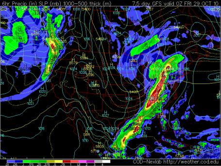
First Flakes? It's still 6 days away, but the latest GFS model is hinting at enough cold air aloft, and enough "wrap-around moisture" - sometimes referred to as "backlash" by dazed meteorologists - for sprinkles and light rain to mix with a few wet snowflakes next Thursday. The chance of accumulating slush is pretty good over northern Minnesota, but ground temperatures are still quite mild - I don't expect any accumulation over central or southern MN.
But don't be surprised if you spot the first flakes of the season next Thursday, coming 1-2 weeks later than usual across much of Minnesota.
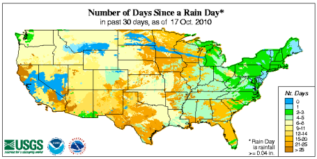
Growing Drought. It's been nearly 4 weeks since many towns in the Upper Midwest have seen measurable rain. A deeper, more problematic drought is spreading across the southeast and parts of the Midwest, from Indianapolis and Louisville southward to New Orleans, Huntsville and Atlanta. Meanwhile the northeastern U.S. has seen soaking rains in recent weeks. The pattern is breaking down, beginning Saturday, as wet, Pacific storms begin to penetrate farther inland.
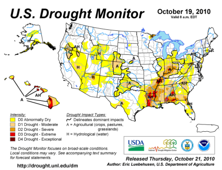
Drought Monitor. Parts of the Minnesota Arrowhead are still experiencing moderate to severe drought, but the real concern is well south/east of Minnesota. That said, a good, soaking rain would be welcome before the ground freezes up within 3-4 weeks - setting the stage for a more productive spring planting season in 2011. Click
here for the latest Drought Monitor.
Gulf Oil Spill - 6 Months Later. Half a year after the largest oil spill in U.S. history the Gulf of Mexico is trying to return to some sense of normalcy. An estimated 170 million gallons of crude was released into the Gulf - but coastal marshes are showing signs of recovering, 90% of the waters have been reopened for fishing. Even so, there is lingering sense of pessimism and uncertainty over the long-term implications. The health of oyster beds is very much in doubt, as described in this
article from U.S. News And World Report.
Why Winds Are Slowing. Winds at surface level have decreased by 5-15% at 73% of reporting stations over North America since 1980, and researchers are scratching their heads trying to understand why. It's a global phenomena, less wind could be bad news for alternative energy investments focused on wind turbines. Increasing amounts of vegetation could be one reason, but the jury is still out. Another theory: wind arise from a contrast in temperature, the greater the north/south extremes in temperature, the stronger the winds have to blow to keep the atmosphere in a state of equilibrium. As warming accelerates (especially at northern latitudes) the "baroclinic zone" (marking the zone of greatest temperature contrast, and strongest winds blowing overhead) shifts north into Canada, possibly resulting in a diminishing of winds farther south across the USA. More from Nature Magazine
here.
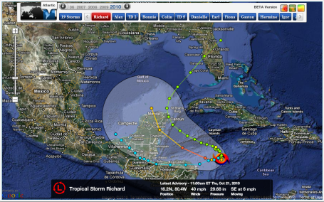
Tropical Storm Richard. The 17th named storm of the season has formed southwest of Jamaica, peak winds of 40 mph. "Richard" is forecast to track to the northwest - it could enter the Gulf of Mexico by the weekend, threatening Florida early next week, but the ultimate path remains something of a mystery. More on Tropical Storm Richard
here.
Rocket Launch! To mark the 100 year anniversary of the Boy Scouts, Jacob Smith wanted to not only "be prepared" but get his rocketry merit badge. 3,130 model rockets set off AT ONCE, setting a new world record. Very impressive - click
here to see the blast-off!
Chicago Area Boy Calls 911 Complaining About Bad Dinner. PROVING that it's a slow weather-day, I've included this
story about a Buffalo Grove boy who had the nerve to call 911. I've had some bad meals in my day (not recently honey, in the unlikely event you're reading the weather blog - your meals are always PHENOMENAL!) but I never thought to call 911. Duh. (thanks to Gawker.com for that one).
 Back to "Average"
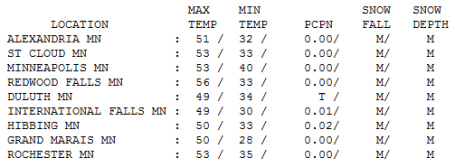
. It's been nearly 2 weeks since we've experienced a cooler-than-average day. In spite of bright sun the afternoon high only reached 49 at Duluth, 53 at St. Cloud and the Twin Cities, about 3-4 degrees cooler than normal (for a change). A south wind will lure the mercury well into the 60s Friday, near 70 south/west of the Minnesota River - the last lukewarm day in sight.
Paul's Conservation MN Outlook for the Twin Cities and all of Minnesota:
Today: Mostly sunny and spectacular (last lukewarm day of 2010?) Winds: S 10-15. High: 69 (many thermometers topping 70 south/west of the Twin Cities).
Friday night: Dry, beautiful evening for football (readings falling into the 50s). Clouds increase overnight. Low: 49
Saturday: Overcast with rain developing. High: 56
Saturday night: More rain, patchy fog. Low: 43
Sunday: Cloudy and soggy with periods of rain. High: 54
Monday: Still damp with more rain. High: 55
Tuesday: Showers taper with partial clearing, windy and cooler. High: near 50
Wednesday: More clouds than sun with a gusty wind. High: 47
Thursday: Raw and windy with sprinkles, even a few flurries mixing in north/west of the metro area. High: 44
*
Halloween Outlook: Some sun, highs in the mid to upper 50s, Trick or Treat temperatures near 50 Right now odds favor dry weather on Oct. 31.
Last 70 of 2010?
The only predictable thing about the future is that it won't be anything like what the "experts" think will happen. Between automation, outsourcing and the Internet the risks for businesses, big an small, have never been greater. I don't pretend to have the answer key, but launching 6 Minnesota companies has made me humble - and given me a new appreciation for flexible business models. Not once did any of my ventures turn out the way I thought they would. I'm on the speaking circuit - I encourage big companies to think like entrepreneurs. Kill the "cash cow" before a competitor does it for you. Break into small teams in stealth mode, plant seeds that will pay off down the road. Intel's Andy Grove had it right. "Only the paranoid survive."
One more lukewarm, shirtsleeve afternoon is on tap, a shot at 70 by 4 pm (average for Sept. 15!)
Soak it up, because a southern storm will spread light rain into town Saturday. The models are hinting at half an inch of needed rain into Sunday. Have a Plan B (indoors) for much of the weekend. Colder air arrives next week on raw winds, chilly enough for a coating of snow up north by midweek. Halloween? Near 50 & dry. No blizzards this year.
Moon Not Only Has Water, But Lot's Of It. This story was an eye-opener: it turns out our nearest celestial neighbor has plenty of water. In 2009 NASA slammed a rocket into the moon's surface at over 5,000 mph. A pair of orbiting satellites took measurements of the aftermath, calculating that 5.5% of the total lunar mass of the soil impacted contained water ice. The implications are potentially enormous: harvesting water on the surface of the moon? Who would have thunk it. (note: this story from the WSJ may require a subscription).
Where Good Ideas Come From. I'm fasciinated with technology & innovation, specifically the (sometimes messy) process of creativity and new ideas. From failure often comes the seeds of eventual success for a tenacious few that are incapable of giving up - people determined to connect the dots differently and find a way to succeed over the long haul. Americans are very good at this process, and always have been, this
article exploring some of the biggest ideas and breakthroughs that came about the hard way.
Four Reasons Why You Choke Under Pressure (And How To Avoid Them). A weatherguy writing about choking? How novel. I found this (lifehacker) article interesting. All of us are loading more onto our plates. Technology was supposed to liberate us. Ha! Now we're all running around trying to do more (with less). A few interesting ideas in
this post, food for thought.
New Findings Could Sway Thought On Climate Change. Earth's atmosphere has warmed dramatically in the past, but these extreme warming trends were traced to astronomical changes in Earth's orbit, or volcanic eruptions releasing greenhouse gases into the atmosphere. New
research suggests "pulses" of warming in the past - data which could help to make climate modeling more accurate and reliable going forward.
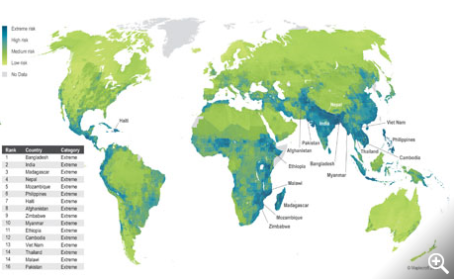 Climate Change Threatens Emerging Superpowers, Report Warns
. India and Bangladesh face the greatest long-term risk to their populations, ecosystems and emerging businesses, according to a survey of 170 countries. As you can see - most of the at-risk nations are in Africa, Asia and Central America. More details
here.
Study: Climate Change Could Cost U.S. Gulf Coast Billions. Wind and storm damage costs the Gulf coast states an average of $14 billion a year. Coastal assets in 77 counties and parishes face a variety of threats: rising water levels, land subsidence and other factors - by 2030 the combined impacts of development and various environmental factors could face cumulative losses of $350 billions, 2 to 3% of GFP. More from AFB
here.


No comments:
Post a Comment