Weather Headlines
*
October 2010: new record for sunshine. Mark Seeley's excellent WeatherTalk
blog has a report about sunshine in the Twin Cities. Apparently the first 3 weeks of October were the sunniest on record, 36% above average. We've had 14 sunny days and 5 partly cloudy days, according to NWS records.
*
October 2020 Temperatures: 57.7 F. (average is 48.6 F). 5th warmest on record (since 1891).
*
Weekend rain won't be as heavy as earlier predicted. Latest models print out closer to .25" (down from just over 1" on Thursday's model run). Heaviest, steadiest rains arrive tonight - just light, showery rain and sprinkles much of today and Sunday.
*
Next week will look and feel like late October. 1-3" of slushy snow is possible over far northern MN next Tuesday/Wednesday, it may be just cold enough for a few flurries to mix in with windblown sprinkles by Wednesday as close as St. Cloud and the far northern suburbs of the Twin Cities.
Not sure we'll see any snow here in the immediate metro midweek, but it will be a very close call.
* Skies clear and winds subside next Thursday,
setting the stage for the first widespread frost/freeze of the season in the immediate metro area (about 3 weeks later than usual).
Brave Son. That's my 22 year old son, Walt, who couldn't resist one (last) dip in the lake. Water temperature:
53 F. He won't be doing that again anytime soon, but I
give him kudos for braving the chilly waters of Tonka Bay.

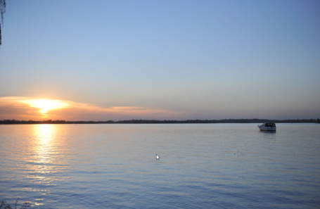 Boating In Late October...in Minnesota?
 Where are we living again? I
think that's a 10 meter Trojan anchored just offshore, on October 22, 2010. Remarkable. And no, it won't last.....but what an October!
Rough Winter? Not According To The Woolly Bear Caterpillar. Here's a nugget from WeatherNation meteorologist Bryan Karrick: "According to the Old Farmer's Almanac, the longer the middle brown band, the milder and shorter the coming winter; the shorter the brown band, the longer and more severe winter will be." Looks like a pretty long middle brown band to me, implying a "short & mild" winter. Uh huh. I just found myself on a map of the USA. Short, easy winter? I seriously doubt it. Don't these woolly bear caterpillars know a La Nina is brewing, which favors colder, snowier winters for Minnesota? Talk about mixed messages.
.
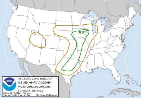
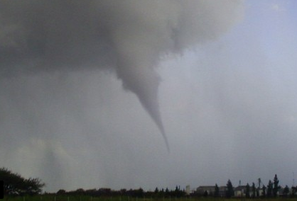
Saturday Severe Outbreak? Hard to believe on October 23, but a fairly intense storm approaching from the south may spark a few strong to severe storms as close as Iowa. Tornado-chasing in late October? Rare, but not unprecedented.
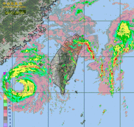
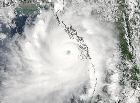
Super Typhoon "Megi". The same typhoon (same thing as a hurricane) that hit the Philippines with sustained winds close to 200 mph is now dealing a punishing blow to Taiwan. At least a dozen people are dead, 6 missing, a quarter million people have been forced out of their homes due to mudslides and extreme flooding. Reports of 45" rain in 48 hours in Taiwan. Winds are sustained at 110 mph but wind shear is weakening the storm, and it may hit the mainland of China as a Category 1 storm. Even with a collapsing "eyewall" Megi is a large and powerful storm capable of considerable wind and storm surge damage even at category 1 strength. Torrential rains will continue to be a problem, since Megi is moving so slowly.
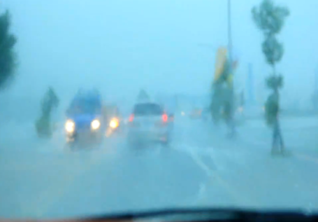
Driving Through a Typhoon. No, the guy driving along this rain-swept road in Taiwan is not taking the shaky video - it appears his frantic passenger is. This YouTube
clip captures the full fury of "Megi", which unloaded nearly a year's worth of rain in less than 2 days as it passed off just south of the island.
Cyclone "Giri". Very powerful Cyclone Giri made landfall along the coast of Myanmar (Burma) Friday morning as a Category 4 hurricane with sustained winds of 145 mph, the most severe cyclone to ever strike Myanmar. Giri is one of the strongest cyclones (same thing as a hurricane) ever to hit Myanmar, sustained winds 10 mph stronger than Cyclone Nargis, which left 138,000 people dead in 2009. However, this time Giri is hitting a portion of coastal Myanmar that is not low-lying, the major threat will be wind damage and flooding from heavy rains. Giri has put on an impressive intensification "burst" over the last 18 hours, strengthening from a 60 mph tropical sstorm at 8 am Thursday to a 145 mph Category 4 storm by 2 am Friday morning.
More Tornadoes In Unusual Places: This Time Argentina. A major tornado just struck Formosa, on the northern tip of Argentina, leaving 6 dead and at least 116 injured. More from a (Google-translated) Argentinian web site
here.
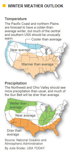
The Heck with the Caterpillar - Good News For Snow Lovers? A strengthening La Nina (cooling phase in the Pacific Ocean) SHOULD mean a bias toward colder, snowier conditions this upcoming winter. No mild El Nino to save us this year. As I've said (ad nauseum) many times before - every La Nina is different. What's happening in the equatorial Pacific is only one of many factors that will influence our winter weather patterns. USA Today has a good recap of the brewing La Nina and how it may influence our winter weather
here.
Place Your Bets. Here is the latest winter prediction: November through February, courtesy of CPC, the Climate Prediction Center, a division of NOAA. Graphics courtesy of USA Today.
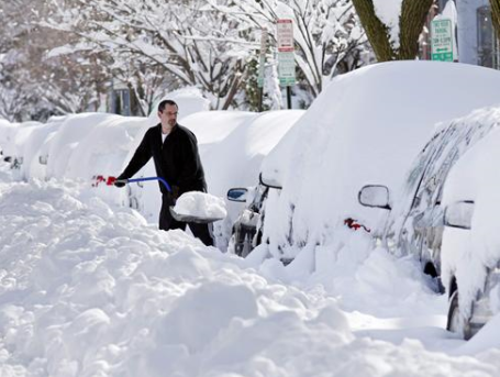
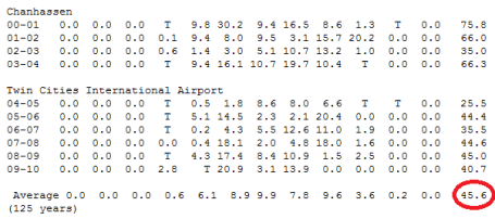
Twin Cities Snowfall. For the record, the 125 year average is 45.6" snow for MSP. The official snow reporting site moved from Chanhassen (at the local NWS headquarters) back to MSP International in 2004, so there isn't quite as much continuity in the records as we'd like to see, but if you run the numbers
since 2000 the average winter snowfall is 47.8". The extremes have been pretty remarkable, from nearly 76" the winter of 2000-2001 to a meager 25.5" the winter of 2004-2005. What do you think?
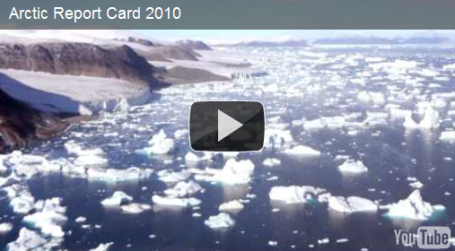
Sea Ice Melting As Arctic Temperatures Rise. The Washington Post has a good
summary of what's happening in the Arctic this year. Bottom line: the third lowest amount of ice since satellite measurements were first started in 1980. Summer temperatures over northern Canada were as much as 7.2 F. warmer than average. Click
here to read NOAA's "report card" for Greenland, northern Canada and the Arctic Region.
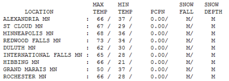 Aug-Tober Hangs Tough.
 What a Friday, 60s statewide (except for poor Grand Marais). 67 at St. Cloud, 68 in the Twin Cities, 70 at Mankato and Albert Lea, 71 at Sauk Centre, 72 Montevideo, and a lukewarm 73 at Redwood Falls. Wow.
Paul's Conservation MN Outlook for the Twin Cities and all of Minnesota:
Today: Mostly cloudy with a little light rain and drizzle. Winds: East 8-13. High: near 60
Saturday night: More rain, patchy fog. Low: 48
Sunday: Still drippy with periods of light rain likely. High: 59
Monday: Breezy and relatively mild, another surge of rain arrives. High: 61
Tuesday: Cold front arrives. Gusty and colder with a few wind-whipped showers and sprinkles. High: 54
Wednesday: Windy and raw with sprinkles - even a few flurries mixing in up north. High: 46 (wind chill in the 20s and 30s statewide).
Thursday: First widespread frost/freeze of the season for the immediate metro area? Bright sun, less wind. High: 49
Friday: Windy, a bit milder with intervals of sun - a dry day. High: 55
Saturday (Oct. 30): Plenty of sunshine, not bad for late October. High: 57
Halloween: Mix of clouds and sun, probably dry, milder than average. High: 58 (Trick or Treat temperatures in the low 50s).
Winter Contradictions
"How much snow this winter, Paul?" A dangerous question. Answering with a specific inch amount would border on lunacy. Like trying to predict where a tornado will touch down, months in advance. Good luck with that. Today's weather blog shows a woolly bear caterpillar with a long, brown stripe, implying a milder, shorter winter. And yet NOAA has just come out with the official winter outlook, a strengthening La Nina (cooling phase of Pacific Ocean), favoring a colder, snowier winter for the Upper Midwest.
It's been grim for snow-lovers. Last winter 41" snow fell at MSP; the 10 year rolling average since 2000 is 48". The trend is for less snow, more mid-winter rain & ice. Will it be like 2000-2001 (76") or 2004-2005 (25.5")? Place your bets.
Nearly an inch of long overdue rain falls on Minnesota this weekend (if it was 15 degrees colder we'd be shoveling out from 10" of snow, give or take). Lousy timing, but we need this rain to recharge soil moisture before the ground freezes solid in less than a month.
Colder air surges south next week, a few inches of slushy snow possible up north by midweek. We warm up late in the week; odds favor a dry Halloween, highs in the upper 50s.
Fox4 Social Media Spoof An Unexpected Internet Hit. Yes, as local TV stations get rid of more and more anchors and reporters they're becoming increasingly dependant on "citizen journalism" - using social media to try to score points with viewers. YouTube. Tweets. Facebook posts - all these new platforms available to inform the public! But
this is really taking it way too far...


No comments:
Post a Comment