* If the official Twin Cities temperature (MSP International Airport) reaches 32 F. Thursday or Friday morning (very possible) we will tie a record for the 10th latest 32 F. on record.
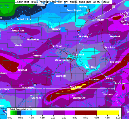
* Latest models print out 1-2" of rain between Sunday and Wednesday (mixing with wet snow central and northern MN Tuesday night into Wednesday).
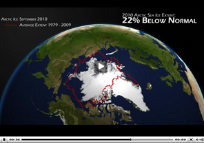
Arctic Report Card: Region Continues To Warm At An Unprecedented Rate. NOAA just released a summary of summer conditions in the Arctic region: the third lowest amount of summer ice since satellite records began in 1979 (only surpassed by 2007 and 2008, 22% below the long-term average. A few highlights of the report:
- Greenland is experiencing record-setting high temperatures, ice melt and glacier area loss.
- Summer sea ice continues to decline — the 2009-2010 summer sea ice cover extent was the third lowest since satellite monitoring began in 1979, and sea ice thickness continues to thin. The 2010 minimum is the third lowest recorded since 1979, surpassed only by 2008 and the record low of 2007; and
- Arctic snow cover duration was at a record minimum since record-keeping began in 1966.

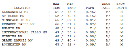
Better Than Advertised. A surge of dry air tangled up in the storm circulation coaxed some (unexpected) sunshine out of our midday sky, enough for 65 in the Twin Cities and Rochester. Thicker clouds kept temperatures cooler north/west, only 48 at Duluth, 52 at St. Cloud and 51 up in Alexandria (where nearly half an inch of rain fell).
Paul's Conservation MN Outlook for the Twin Cities and all of Minnesota:
Today: Periods of light rain, unseasonably mild. Winds: E/NE 8-13. High: 62
Sunday night: Light rain, patchy fog possible. Low: 55
Monday: Still feels like September. Unseasonably mild with clouds, a few showers/T-storms possible late. High: 68
Tuesday: An intense storm develops directly over Minnesota. Heavier rain, becoming windy. High: 55
Wednesday: Blustery and raw with light rain and sprinkles (mixing with wet snow north). Winds gust to 35 mph. High: 49
Thursday: Feels like late October. Winds ease with slow clearing - first frost possible late Thursday night. High: 47
Friday: Partly sunny, becoming windy again by afternoon. High: 48
Saturday: Probably the nicer day of the weekend. Mix of clouds and sun, dry. High: 54
Halloween: Any sun quickly gives way to clouds - drizzle by afternoon, light rain possible late. Looks soggy for Trick or Treating. High: 57 (Trick or Treat temperatures falling through the low 50s into the upper 40s).
Weather Psychology
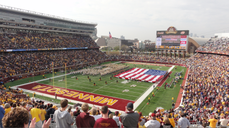
"Paul, I wish I could have a job where I get paid to be right half the time!" That gets funnier every time I hear it. Yes, Saturday was nicer than predicted. The sun came out for 25 minutes at TCF Stadium; people were peeling off jackets & ponchos (the crowd cheered for me to keep my shirt ON).
It's generally acceptable if the weather turns out better than predicted. Most Minnesotans are OK with that. But if its the other way around; you predict sun and it pours? Not a pretty sight, especially on a weekend. As a result meteorologists (as a profession) tend to err on the side of pessimism for the weekend outlook, at least that's been my experience.
What a month, the sunniest, driest and 5th warmest October on record, to date. Looks like the 10th latest frost on record; 1st chance of 32 F. Thursday.
Light rain today eases up Monday (70 possible), then heavy rain Tuesday as an intense storm spins up directly overhead. Over 1" of rain may fall by Tuesday, ending as flurries up north Wednesday as winds gust to 35 mph. Friday frost gives way to Saturday sun, a little drizzle possible for Halloween. Snow? The first chance of any real accumulation comes on Election Day. Great timing!

No comments:
Post a Comment