Coincidence? Maybe. But the coincidences seem to be piling up...
* Light snow/flurries are in the forecast today, but temperatures will stay above 32 F - meaning most roads should just be wet. Tonight the mercury dips below freezing, and a few icy patches on area highways can't be ruled out.
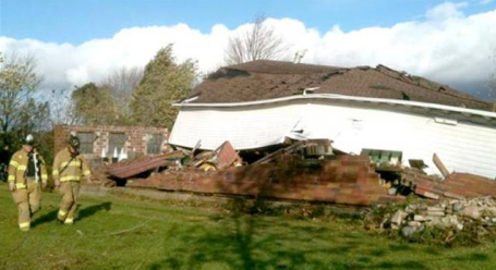
* High Wind Warning still in effect through the afternoon for winds gusting to 50 mph - not quite as intense as yesterday, but still capable of bringing down tree limbs and powerlines.
* First frost/freeze still likely late Thursday night - Friday morning as temperatures dip into the mid/upper 20s. It should be the 10th latest 32 F. in the Twin Cities in modern-day records.
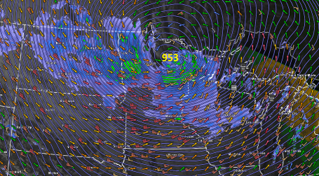
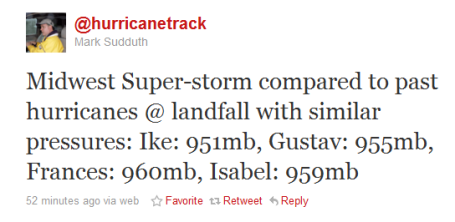
October Superstorm. Lowest Pressure On Record For The USA. Welcome to the Land of 10,000 Weather Extremes. Yesterday a rapidly intensifying storm, a "bomb", spun up directly over the MN Arrowhead, around mid afternoon a central pressure of 953 millibars was observed near Orr. That's 28.14" of mercury. Bigfork, MN reported 955 mb, about 28.22" of mercury. The final (official) number may be closer to 28.20-28.22", but at some point the number becomes academic. What is pretty much certain is that Tuesday's incredible storm marks a new record for the lowest atmospheric pressure ever observed over the continental USA. That's a lower air pressure than most hurricanes, which is hard to fathom.
How did this happen, especially coming after 4 dry, mild, unusually sunny & quiet weeks/row? Generally speaking, the larger the "baroclinicity" (the north-south temperature contrats across N. America) the greater the potential for an epic storm to develop. Yesterday all the ingredients converged over Minnesota, an unusually powerful jet stream core (blowing at close to 200 mph 5-8 miles overhead). The approach of a "jet streak" aloft caused a partial vacuum to form over the MN Arrowhead, air rushing into this low pressure system accelerated to speeds as high as 60 mph, downing trees and powerlines, cutting off power to WeatherNation in Excelsior for a time during the evening hours.
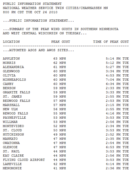
* Shortly before 8 am Tuesday the barometric pressure fell to 28.61" in the Twin Cities. That's the second lowest pressure ever observed at MSP, according to NOAA.
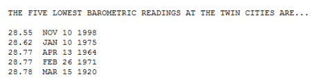
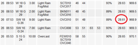
Twin Cities Data. Shortly before 8 am Tuesday the pressure dropped to 28.61" at MSP, making this the second lowest air pressure ever recorded in the Twin Cities.
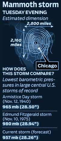
Perspective. For the record: the lowest pressure I could find was 28.22" at Orr. That's the lowest air pressure on record for the continental USA, deeper than the Armistice Day Blizzard and the 1975 storm that sunk the Edmund Fitzgerald. Thanks to WGN meteorologist Tom Skilling and his excellent blog for a little perspective.
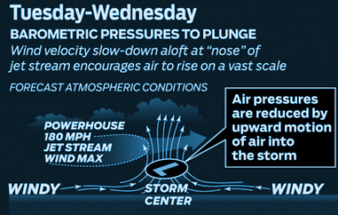
Why Was It So Windy? Powerful jet stream winds howling at 150+ mph about 4-6 miles above the ground created a partial vacuum, a rapidly intensifying low pressure system, allowing winds to accelerate into the center of this storm, resulting in hundreds of delays at area airports, even a few rare tornadoes as close to us as Wisconsin on Tuesday.
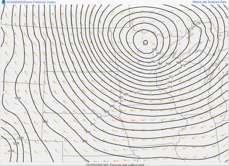
Maps In Motion. Click here to see an animation of the developing storm as it tracked northeastward across Minnesota. Stronger than the Armistice Day Blizzard, the Halloween Superstorm of 1991, even the epic storm that sank the Edmund Fitzgerald iron ore ship on Lake Superior in 1975. Confused about millibars (yes, we're going to be pushed, kicking and screaming, into the metric system) click here to see a handy conversion calculator where you can convert millibars into inches of mercury, and vice versa.
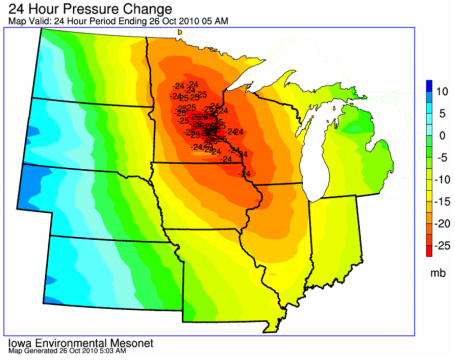
"Bombogenesis" A pressure fall of 24 millibars or more in less than 24 hours is referred to as a "bomb" by meteorologists. It's a metaphor, but the storm did literally explode in intensity as it wrapped up over the MN Arrowhead. More from the Iowa State University Agronomy Department here.

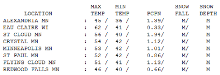
Wet & Windy. Nearly 2" of rain fell at St. Cloud, where a 24 hour rainfall record was set (1.42" in 24 hours, breaking the old record of 1.33" in 1941). Just over 1" fell in the Twin Cities (MSP International), but Eau Claire, WI only picked up .33" rain.
Paul's Conservation MN Outlook for the Twin Cities and all of Minnesota:
Today: High Wind Warning Continues. Blustery and raw with light snow and flurries, a coating of slush can't be ruled out on some lawns and fields. Winds: W/NW 25-50. High: near 40 (wind chill in the mid 20s).
Wednesday night: Windy with flurries - a few roads outside the metro may become slippery. Low: 32
Thursday: A mix of clouds and sun, still windy (but not quite as wild as recent days). Winds: NW 15-30. High: 41
Friday: Frost/freeze early, then plenty of sun, winds ease up considerably. High: 49
Saturday: High pressure nearby: blue sky and relatively light winds. High: near 50
Saturday night: Mostly clear and chilly. Low: 32
Halloween: Any sun gives way to increasing clouds. Probably dry for Trick Or Treating. High: 49 (Trick Or Treat temperatures in the mid 40s).
Monday: Mostly cloudy, a few sprinkles possible. High: 48
Election Day: No major weather headaches expected close to home. Partly sunny, seasonably cool. High: near 52

Todd Frostad. "The Walking, Talking Barometer."
Walking Barometer
My good friend & business partner, Todd Frostad, is a walking, talking barometer. An old college (weight-lifting) injury causes his joints to swell whenever the barometric pressure rises or falls. The greater the jump in pressure, the more he complains. Todd is locked in his office today, very unhappy about the latest atmospheric turn of events. Yesterday the USA set an all-time record for the lowest pressure ever observed: 28.22" over Orr, MN. That's deeper than the Halloween Superstorm, the Armistice Day Blizzard, even the mega-storm that sank the Edmond Fitzgerald in 1975. This storm has a lower pressure than some mature hurricanes - almost 2,500 miles wide, an impressive display of what can spin up in late October.
The greater the north-south contrast in temperature, the stronger the winds have to blow to keep the atmosphere in equilibrium. Cold air wrapping into the storm will spark a changeover to wet snow today. The ground is relatively mild: much of that snow will melt-on-contact. Even so a slushy coating is possible, maybe 2-4" inches far north/west. A hard freeze Friday morning gives way to sunnier weather late week, a cool, dry sky for Halloween treats.
* Election Day, 2010 looks dry (partly sunny) with highs in the upper 40s to low 50s. No good meteorological reason not to do your civic duty and vote.
* No more monster-storms are in sight - next week looks relatively quiet with highs in the 40s and low 50s, a few degrees cooler than average.
* First weekend of November may include hints of Indian Summer. Highs may reach the mid 50s to near 60 November 6-7.

No comments:
Post a Comment