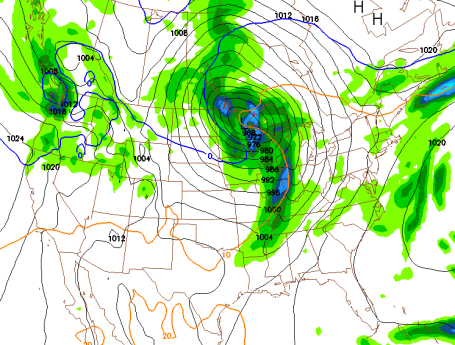
Record-Setting Tuesday? Computer models are predicting today's storm undergoing "bombo-genesis" near Duluth today, with a central pressure as low as 28.3" by evening. If the computers verify we may very well set a record for Minnesota's strongest storm (measured via barometric pressure) on record. According to Jesse Ferrell's
blog at Accu-Weather.com Minnesota's deepest storm on record was 28.47" near Rochester. We're making national headlines - more on today's potential record (low pressure) from USA Today
here. Remarkable.
*
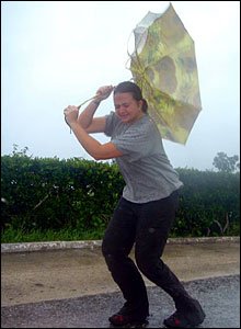
Umbrella Alert. The heaviest rains arrive today, when over 1" of rain may fall. Expect standing water on area highways and slower commutes as a result. Come to think of it that umbrella may be all but useless today as winds gust to gale force, over 40-50 mph at times later today.
*
High Wind Warning: in effect from this morning through Wednesday evening for sustained winds of 20-40 mph with gusts as high as 55-60 mph, capable of causing minor damage (downed trees and powerlines). Take time to secure any loose items (lawn furniture, trash cans, etc). in your yard as soon as possible.
*
Record Low Pressure? Some of the computer models intensify the storm over northeastern Minnesota to 960 millibars by Wednesday morning, that's roughly 28.34 inches of mercury! The all-time record for low pressure is 28.42" set on November 10, 1998. We may come very, very close.
*
First Snow? The latest NAM model is hinting at temperatures in the lowest mile of the atmosphere < 32 F by Wednesday afternoon/night. A few inches of snow will accumulate north of Brainerd and Grand Rapids, possibly enough to shovel and plow. A little slush is possible from St. Cloud into the Twin Cities Wednesday night. Stay tuned.
*
First Frost. The predicted low for Thursday morning is 28 F in the Twin Cities. That should be the first sub-freezing temperature of the season, coming 3 weeks later than average. A Thursday morning frost/freeze would be the 10th latest 32 F. for MSP since 1871, according to NOAA and the MN State Climate Office.
*
Don't Panic. In spite of this week's taste of November-like weather, no prolonged Arctic air is in sight - yet. In fact the GFS model keeps highs consistenly in the mid 40s to mid 50s through the second week of November.
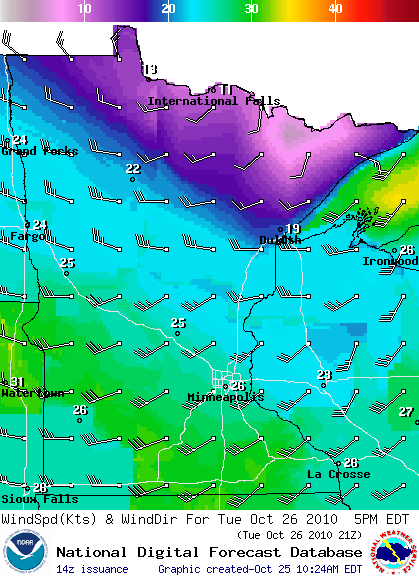
High Winds. A high wind watch is posted for all of central and southern MN for Tuesday & Wednesday. Sustained winds are forecast to be 26 mph by 5 pm today, with gusts over 50 mph at times. Some minor wind damage can't be ruled out, downed trees and powerlines - the strongest gusts just south/west of the Minnesota River Valley. The reason? A strong north-south contrast in temperature, what meteorologists refer to as "baroclinicity" is setting the stage for an especially strong area of low pressure to develop near Duluth. The greater the contrast in temperature, the stronger the winds have to blow to keep the atmosphere in a state of equilibrium. That why winds in the tropics are usually light - very little in the way of temperature extremes within 2,000 miles of the equator (save for the occasional hurricane, of course).
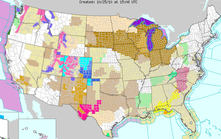
High Wind Watch. All those brown counties stretching from South Dakota to Michigan are under a high wind watch, calling for sustained winds of 20-40 mph with a few gusts as high as 50, even 60 mph. To get the latest watches/warnings from NOAA click
here.
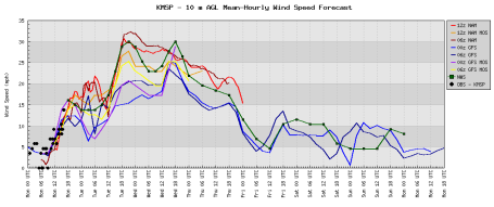
Very (VERY) Bad Hair Day. In my case I've had a few bad hair DECADES, but that's another story. Winds are forecast to peak (sustained between 30-33 mph) from midday today through midday Wednesday as air accelerates into the center of a partial vacuum, a rapidly intensifying storm spinning up over northern Minnesota. Yes, we've been pampered for the better part of a month - a serious (windblown) reality check is at hand.
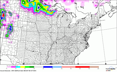
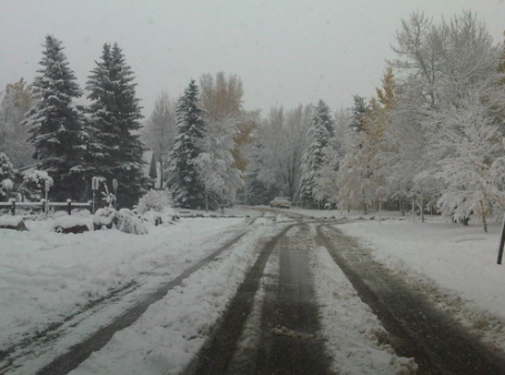
First Snow Accumulation Of The Season? The GFS model is hinting at a "plowable" snowfall across the northern third of Minnesota as cold air drains south out of Canada, changing rain over to wet snow by Tuesday night (up north). A little slush is even possible from St. Cloud into the far northern suburbs of the Twin Cities. Ground temperatures are still relatively mild for late October - snow will melt on contact, but after dark Wednesday evening I wouldn't be shocked to see a slushy accumulation into the immediate Twin Cities metro. Here we go!
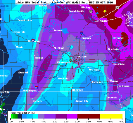
October Soaking. The latest NAM model prints out 1-2" of rain across most of the area (heaviest amounts probably fell overnight - rain should be fairly light during the day today, but high winds will make that light rain VERY unpleasant). Rain changes to snow tonight and Wednesday as cold air wraps into this (intense) storm spinning up directly over northern Minnesota - slush may pile up on some lawns and fields from near Brainerd and St. Cloud to Lake Mille Lacs, with flurries possible tomorrow in the metro area. Yep, it's time.
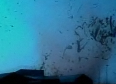
Too Close For Comfort. What's in like to be INSIDE a tornado? These amateur storm-chasers found out (the hard way) as a major tornado swept through the town of Rice, Texas. Med school student Eric Myer took this amazing video with his smart phone - the tornado lifted 11 train cars off the tracks - nearby observers were injured by golf-ball size hail, many huddled in a freezer to avoid the worst of the wind (good move). The amazing footage from WPTZ-TV is
here.
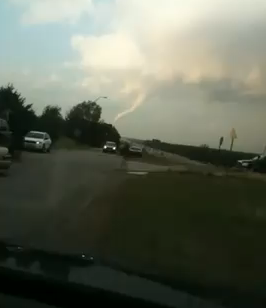
A Different Perspective. One of the challenges of "chasing" tornadoes is trying to be in the right place at the right time. More times than not you're too far away - breaking the speed limit (bad idea) trying to catch up to the parent thunderhead. That was the case with
these chasers on the trail of the same twister near Rice, Texas, courtesy of YouTube.
Aftermath. Tornadoes in late October are rare, but certainly not unprecedented. As colder air penetrates farther south many regions of the USA experience a secondary tornado peak from late September through late October. Several dozen tornadoes have touched down on the Deep South since last Friday -
here is the aftermath of one particularly intense tornado that crossed an interstate highway (I-45) near Corsicana, Texas.
Paul's Conservation MN Outlook for the Twin Cities and all of Minnesota:
Today:
High Wind Warning. High winds, periods of light rain - slow commutes.
Minor wind damage can't be ruled out. Winds: SW 20-40, gusts past 50 mph at times. High: 50
Tuesday night: Rain tapers to showers, still very windy. Low: 35
Wednesday; High Wind Warning continues. Blustery and raw with very light snow and flurries. High: 42 (wind chills dipping into the 20s)
Thursday: First frost/freeze of the season (coming 3 weeks later than usual). A mix of clouds & sun, less wind. High: 43
Friday: Intervals of sun, dry and quiet, temperatures closer to average. High: 51
Saturday: Bright sun, light winds - nicer day of the weekend with a hint of Indian Summer. High: 58
Saturday night: Mostly clear and seasonably cool. Low: 42
Halloween: Sun dimmed by increasing clouds. Dry for Trick or Treating. High: 53 (Trick or Treat temperatures falling through the 40s).
Monday: Increasing and thickening clouds, a few PM sprinkles? High: 52
Reality Slap
It was as inevitable as gravity, taxes and Viking interceptions. The party is over. After nearly a month of extraordinary weather, record-setting sunshine & September-like warmth, an atmospheric hangover is setting in today as a powerful storm spins up near Duluth. Air accelerating into a low pressure "bomb", a partial vacuum, will reach speeds as high as 40-60 mph today & Wednesday. In fact the NAM model is predicting a central pressure of 959 millibars near Duluth this evening, which would be an all-time record for storms spinning up over Minnesota. That translates into a central pressure of roughly 28.30" - deeper than some hurricanes!
A High Wind Watch is in effect. Secure lawn furniture, trash cans, pets and hybrid automobiles; it will look & feel like Tropical Storm Chuck is whipping up outside for the next 36 hours. Today will be the wettest day in sight, a 1-2" soaking for much of Minnesota, replenishing soil moisture for trees, shrubs and plants before the ground freezes up solid within 3 weeks or so.
Enough cold air may wrap into this intensifying storm for a changeover to wet snow, a few inches up north, maybe the first flakes of the winter season for central Minnesota, even a little light snow or flurries in the metro area tomorrow and Wednesday night. Ground temperatures are still relatively mild, the result of recent warmth, so any snow Wednesday evening will probably melt-on-contact. But a light coating of slush can't be ruled out, especially far north metro to St. Cloud Wednesday night.
The first frost/freeze of the season arrives Thursday morning, coming 3 weeks later than usual, the 10th latest frost on record since 1871. We dry out in time for a cool, brisk Halloween. Good timing.
A Real Storm! For the first time in nearly a month a powerful low pressure system is forecast to develop near Duluth. This map shows the predicted weather map for midday Wednesday, showing the "0 C line" at 850 mb, roughly 3,500 feet above the ground, wrapping into western and southern Minnesota. A gradual changeover from rain to snow is likely late tomorrow - by the time it's cold enough for all snow most of the moisture will have shut off - but a little slush can't be ruled out at the tail-end of this storm Wednesday night. Yes, it's conceivable we could be waking up to a little snow on our yards (and temperatures in the mid/upper 20s) Thursday morning. An icy/slushy commute Thursday AM can't be entirely ruled out.
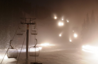
Good News (For Skiers).
Loveland Ski Resort becomes the first official Colorado ski destination to open up for business. As much as 16" of snow may get dumped on some of Colorado's ski resorts - more from USA Today
here.
Like a Postcard. Even
Lance Armstrong got in on the act. In his words, "yep, winter is officially here." No kidding.
20 Dying Technologies. I've been tempted to do this on numerous occasions (take a bat to a printer or fax machine). Nobody wants to invest in "dying technology", hardware or software that's on the verge of becoming obsolete. Check out this
Top 20 List from Bloomberg Businessweek to see if your favorite gadgets (er, "productivity tools") are on the hit list.
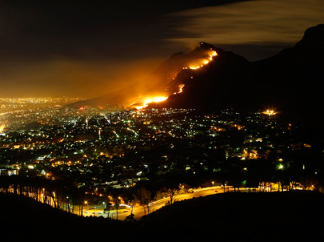
No Waiting On Warming. Temperatures worldwide have warmed close to 2 F. in just the last century. Doesn't sound like much, but the observed warming over much of Alaska, northern Canada and Siberia is closer to 5-8 F. Only a 1 degree F. warming may result in a 73% to FIVE-FOLD increase in brushfires, according to researcher Chris Field, a Stanford scientist. A recent interview with Field can be found
here.
The Election That Wasn't. How do we rebuild America in the wake of the worst downturn in 65 years? Quoting New York Time's columnist (and St. Louis Park hometown boy) Thomas Friedman, "
In the short run, we’ll probably need more stimulus to get the economy moving again so people have the confidence to buy and invest. Ultimately, though, good jobs at scale come only when we create more products and services that make people’s lives more healthy, more productive, more secure, more comfortable or more entertained — and then sell them to more people around the world. And in a global economy, we have to create those products and services with a work force that is so well trained and productive that it can leverage modern technology so that one American can do the work of 20 Chinese and, therefore, get paid the same as 20 Chinese. There is no other way." His post really resonated with me and a few other entrepreneurs I know, read the full op-ed piece
here.
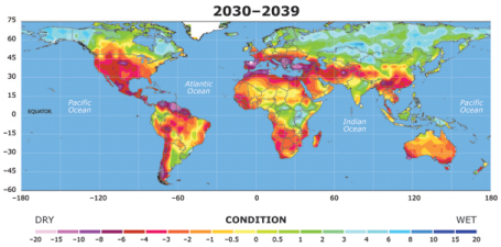
Drought May Threaten Much Of Globe Within Decades. By the end of the 21st century drought may reach a scale that "has rarely, if ever, been observed in modern times." So says a recent
study reported by the National Science Foundation, using an ensemble of 22 different climate models. That includes many of the world's most densely populated areas, and the western 2/3rds of America. Moisture may increase over Scandanavia, much of Siberia, Alaska and eastern Canada, but the bias will lean (strongly) toward increasing frequency and intensity of drought.
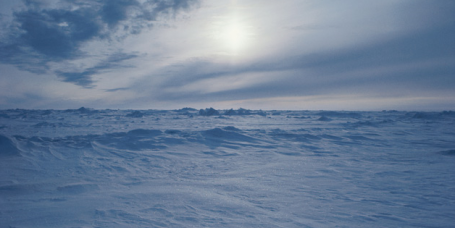
Warmer Arctic Spells Colder Winters. Say what? Talk about a (confusing) paradox. This is why climate change is one of the most complex issues today - there are so many moving parts and bafflying contradictions. According to scientists, the Arctic region is "entering a new state", less ice changing water and wind patterns with 1,000 miles of the North Pole. That's having a domino effect across the rest of North America, changing the position and amplitude of the main, high-speed wind currents, the jet stream winds that snake around the globe. "
Rising heat from a warmer Arctic may increasingly disrupt the circumpolar winds that normally confine cold air within Arctic realms, allowing blasts of cold to hurtle south, similar to what happened when parts of the United States were buried under thick snow this past winter." The complete article from Discovery News and the 2010 Arctic Report Card can be found
here. More on this seeming contradiction (warmer Arctic = more severe winters for USA) from the Capital Weather Gang
here.


No comments:
Post a Comment