
STATE CLIMATOLOGY OFFICE - DNR ECOLOGICAL AND WATER RESOURCES --- FOR IMMEDIATE RELEASE OCTOBER 27,2010
Subject: Minnesota State Record Low Pressure for October 26-27, 2010 storm.
After consulting with the Duluth National Weather Service Office...
28.21 inches (955.2 millibar) is the lowest pressure recorded for the October 26-27 storm. 28.21 inches occurred at 5:13pm on October 26 at Bigfork Minnesota. Bigfork is located in northern Itasca County. 28.21 inches is the result after the measurement was adjusted for the true mean sea level pressure. It's difficult to say if this is a record for the continental United States or not, due to the scattered nature of historical barometric pressure records. It will certainly go down in history as one of the strongest non-tropical storms using pressure as a measurement. The pressure measurement of 28.21 inches at Bigfork is the new Minnesota state record for minimum pressure. The old record was 28.43 inches on November 10, 1998 at both Austin and Albert Lea. The maximum pressure record for Minnesota is 31.11 inches at Collegeville in Stearns County on January 21, 1922. 28.21 inches is the current Minnesota minimum pressure record. If additional research is performed with this event, the record could change.
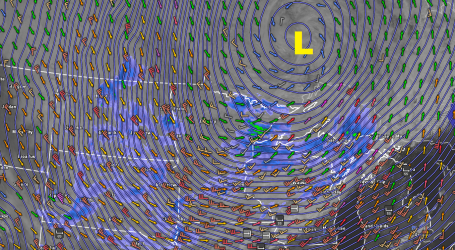
An Historic Storm. At 5:13 pm Tuesday in Bigfork, MN the barometric pressure fell to an unimaginable 949.9 millibars, that's 29.20" of mercury. A sharp contrast in pressure between this "low" and high pressure over the Rockies set up an extreme pressure differential. Air flows from high pressure to low pressure, and this "partial vacuum" spinning up over the MN Arrowhead caused winds to accelerate close to hurricane force swirling into this deepening super-storm. Of course it wasn't a true hurricane (which gets its energy from warm ocean water). Instead this storm derived it's fury from strong north-south temperature contrasts across North America. Other, similar "equinox storms" have developed during September and October, when temperature contrasts from north to south can be significant, but Tuesday's storm set a new meteorological benchmark.
* Meteorological Jealousy? It would appear that Tuesday's mega-storm has sparked a bit of controversy - apparently some weather enthusiasts in the Pacific Northwest are convinced that THEIR storm back in 1995 was even stronger than 28.20" of mercury. Oh my, too many people with far too much free time. Read more about the storm-spat in the American Meteorological Society's blog here.
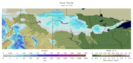
First Flakes. The first "trace of snow" (flurries) were spotted in St. Cloud and the Twin Cities on Wednesday, coming roughly 1 to 1 1/2 weeks later than average. Over 5" snow fell near Fergus Falls and Detroit Lakes, 2-4" north north/west of downtown Duluth, while far northern MN saw no snow accumulation. Click here for more regional and national snow information, courtesy of the National Operational Hydrological Remote Sensing Center, a division of NOAA. Now there's a mouthful.
First Snow for the Twin Cities? Data courtesy of the National Weather Service and the MN State Climate Office
2010: October 27 (trace)
2009: October 10 (.3" snow)
2008: October 26 (trace)
2007 November 5 (trace)
2006 October 11 (trace)
2005 October 6 (trace)
2004 October 17 (trace)
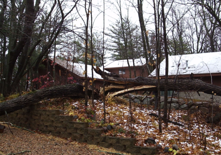
Wind Damage Hitting Close To Home. Thanks to my neighbor, Dan DeWolfe up in Merrifield for reminding me that my cabin (background) is still standing on Pelican Lake. Sustained winds over 60 mph brought down scores of 100-year old oak and maple trees, a few narrowly missing our up-north escape.

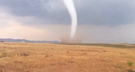
Webcam Of A Tornado. Click here to see a YouTube clip of the tornado that hit La Porte County, Indiana late Tuesday. The camera alternates between the outdoor shot, and an indoor vantagepoint that shows employees scrambling for shelter.
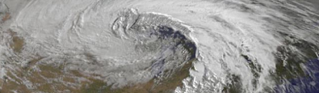
Record Storm Moves Toward New York. The Wall Street Journal reports on the sheer size of this storm, nearly 2,000 miles wide, affecting most of the USA east of the Rockies. 200 high wind reports, over 2 dozen tornadoes, hurricane-force wind gusts over the Great Lakes that left hundreds of thousands of residents without power. A truly epic storm.
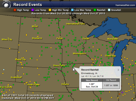
Records, Records And More Records. This is just a week's worth of records across the Upper Midwest. All those green dots/cities are 24 hour rainfall records, the yellow dots are record warm minimum low temperatures. Explore an interactive map from Ham Weather here.

Clever Marketing. Almost makes you hope for a big storm. Any day is a good day for a big, heart-healthy burrito, right?
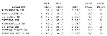
Taste of November. With low, ragged clouds and winds in the 20-45 mph range it was a raw, miserable Wednesday. The first official trace of snow flurries of the winter season was observed in St. Cloud and the Twin Cities, where highs held at 42, the mercury failing to climb out of the 30s far north and west (only 37 in Alexandria).
Paul's Conservation Minnesota Outlook for the Twin Cities and all of Minnesota:
Today: Big step in the right direction. Partly sunny, still windy and chilly. Winds: NW 15-30. High: 42
Thursday night: Clear, frost likely, even a hard freeze (first of the season). Low: 27
Friday: Plenty of sunshine, warming back up to "average". High: near 50
Saturday: Sunnier day of the weekend. Blue sky, cool breeze. High: 49
Halloween. Partly sunny, dry for Trick or Treating. High: 46
Monday: Mostly cloudy, slight chance of a sprinkle or shower. High: 49
Election Day. Partly sunny, dry and quiet. High: 51
Wednesday: Lot's of sunshine, warming up. High: 53
* Freeze Friday morning? A "freeze" is defined as at least 3 hours or more colder than 28 F, cold enough to kill off just about all remaining plant life. We may have those conditions Friday morning. The first 32 F. reading in the Twin Cities will come about 3 weeks later than average, possibly the 10th latest frost/freeze on record MSP.
* Don't Write Off Indian Summer Just Yet. Long-range computer guidance (GFS) is hinting at highs in the mid 50s to near 60 the first weekend of November, November 6-7.
* No more big storms in sight for the next 7-10 days. A weak upper-air disturbance may spark thick clouds and a few sprinkles on Monday.
The "Landicane" of '10
Still searching for my trash cans (& left contact lens). For a moment Tuesday night I thought my home was going to become airborne. Congratulations on surviving the strongest storm in U.S. history. At 5:13 pm Tuesday the barometer fell to 28.19" at Bigfork, Minnesota. A sharp contrast between this "low" and high pressure draped over the Rockies set the stage for near-hurricane force gusts.
"Equinox storms" can be exceptionally severe, feeding on large north-south temperature contrasts, but Tuesday's storm set a new benchmark for crazy extremes from a non-tropical storm.
You'll have a better hair-day today as howling winds ease a bit, clearing skies setting the stage for the first frost/freeze of the season by Friday morning, coming 3 weeks later than usual (the 10th latest frost on record for the Twin Cities). Your begonias are in grave peril.
Now the good news: the sun stays out through much of the weekend. Halloween looks dry and only partly-spooky, Trick or Treat temperatures in the mid 40s. Election Day looks dry (near 50) and quiet weather hangs on most of next week. The GFS model is even hinting at highs near 60 the first weekend of November. Plenty of time to recover!
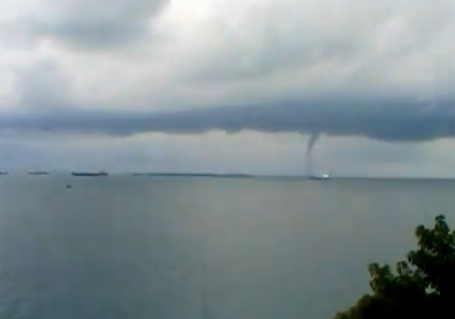
More Tornadoes In Unlikely Places. This time a full-fledged waterspout was spotted off the coast of southern Italy. The YouTube clip is here.
But Wait - There's More! Tornadoes in South Africa? The (amazing) YouTube video clip of a close encounter with nature's wildest wind is here.
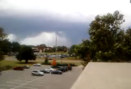
"Supercell" Click here to see YouTube footage of the "supercell" T-storm that went on to drop a tornado on the Huntsville, Alabama area. When you see (rotating) clouds like this - time to hit the basement.
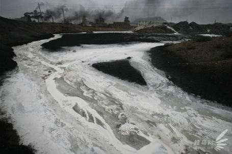
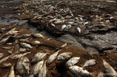
Where "Quality of Life" Is A Distant Dream. I have never seen anything like this - a collection of disturbing images of air and water pollution across China. Meteoric economic growth? Yes, absolutely. But it's come with an incalculable cost to the environment.
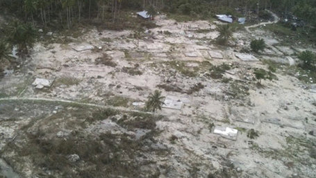
Indonesia Struggles As Tsunami, Volcano Toll Rises. The recent tsunami (tidal wave) triggered by a deep-sea earthquake has left at least 300 people dead in Indonesia. Another 30 people lost their lives from a volcanic eruption in central Java. More details here. Image courtesy of Fox News.
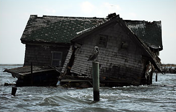
Last House On Sinking Chesapeake Island Collapses. In 1919 Holland Island, in the southeastern part of the Chesapeake Bay, had a population of 360, two stores, a school, and a basball team that traveled by boat to compete with other nearby teams. Recently the last remaining home on Holland Island sank below the (rising) waters of the bay, a combination of rising sea level and sinking land submerging what's left of the island. The Washington Post has more on the transformations taking place in this article.
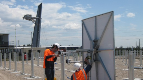
New Solar Tower Thermal Power Plant Being Built That Uses Only Sun and Air. Australia is launching an ambitious new project to focus the sun's rays to compress air, which in turn drives turbines to generate electricity. This may be a more efficient process than using intense sunlight to heat water to run electrical turbines - engineers hope to lower the costs to or even below fossil-fuel sources like coal, natural gas and oil. The complete story is here.


A Remodeling Tool To Green Up Your House. Gizmag.com has an interesting article about ways you can not only green up your house, but save significant money in the process. From the article: "The Eco-Cool Remodel Tool allows you to take a virtual tour through a house, and clicking on household items such as a fireplace or light switch will open up a window of suggestions for improving them. Clicking on “Further information” will take you through the to Green Tools website, which provides more in-depth information about tips and ideas. While some of the information may be local- or country-specific, the Green Tools site is a vast resource that aims not only to provide technical assistance, but also advise on financial grants and incentives, hands-on training, green-building certification, demolition recycling as well as case studies and technical references."
Rivers Disappearing In Drought-Stricken Amazon. The Amazon River is at its lowest level since 1963, some of the connecting tributaries are lower than any time in the last 108 years, the result of one of the worst droughts in the modern record. At least 65,000 familes have been impacted by a dire lack of water. The complete story is here.
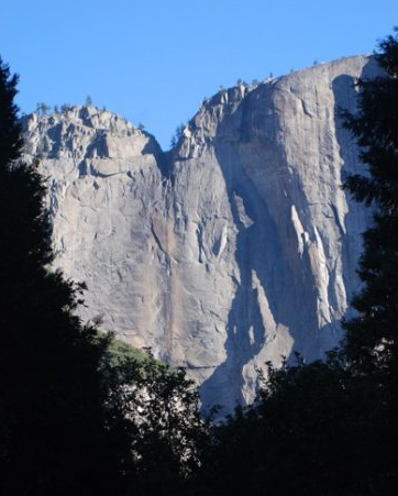
Study Says Climate Change Could Make Yosemite National Park Warmer Than Sacramento. From National Parks Traveler: "By the end of the century, climate change could drive typical temperatures in Yosemite, Sequoia, Kings Canyon, Death Valley, and other national parks in California more than 7 degrees hotter than they were in the later half of the 20th century, according to a new study. The entire report is here.

The Worst Jobs In Science. This post is rated PG (for pretty gross). Whale-snow collector? Fart statistician? And here I thought meteorology was the dismal science. Not even close. Warning: do NOT read on a full stomach. I warned you...
No comments:
Post a Comment