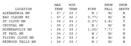
INCHES  LOCATION                 ST  COUNTY           TIME
 ------  -----------------------  --  --------------   -------
 12.00   3 WSW MAPLE GROVE        MN  HENNEPIN         1111 PM
 11.20   WACONIA                  MN  CARVER           0600 AM
 11.00   EDEN PRAIRIE             MN  HENNEPIN         1030 AM
 11.00   1 SSW WYOMING            MN  CHISAGO          0400 PM
 10.40   CHANHASSEN               MN  CARVER           0600 AM
 10.10   NEW HOPE                 MN  HENNEPIN         0102 PM
 10.00   3 N FOREST LAKE          MN  CHISAGO          0104 PM
 10.00   SW BURNSVILLE            MN  DAKOTA           0216 PM
 10.00   MANKATO                  MN  BLUE EARTH       0951 AM
 10.00   MONTGOMERY               MN  LE SUEUR         1130 AM
 10.00   AMBOY                    MN  BLUE EARTH       0930 AM
  9.50   NEW MARKET               MN  SCOTT            0258 PM
  9.50   VADNAIS HEIGHTS          MN  RAMSEY           0708 PM
  9.40   RUSH CITY                MN  CHISAGO          0510 PM
  9.20   ST LOUIS PARK            MN  HENNEPIN         0703 PM
  9.20   NORTH BRANCH             MN  CHISAGO          0703 PM
  9.00   3 NNW MINNEAPOLIS        MN  HENNEPIN         1243 PM
  9.00   CHISAGO CITY             MN  CHISAGO          0301 PM
  9.00   1 NE MINNESOTA LAKE      MN  BLUE EARTH       0953 PM
  8.90   2 W PRIOR LAKE           MN  SCOTT            1239 PM
  8.60   MADELIA                  MN  WATONWAN         1025 AM
  8.50   1 SE CHASKA              MN  CARVER           0112 PM
  8.50   EDINA                    MN  HENNEPIN         0505 PM
  8.30   5 SE ELK RIVER           MN  ANOKA            0148 PM
  8.20   INVER GROVE HEIGHTS      MN  DAKOTA           0715 PM
  8.00   SHAKOPEE                 MN  SCOTT            0703 PM
  7.90   MINNEAPOLIS              MN  HENNEPIN         0600 AM
         MEASURED AT THE MINNEAPOLIS/ST PAUL INTERNATIONAL
         AIRPORT. NEW DAILY RECORD EXTREME. PREVIOUS WAS
         4.0 INCHES SET IN 1997.
  7.30   BLOOMINGTON              MN  HENNEPIN         1248 PM
  7.00   GLENCOE                  MN  MCLEOD           0150 PM
  7.00   WOODBURY                 MN  WASHINGTON       0335 PM
  6.70   LAKEVILLE                MN  DAKOTA           0703 PM
  6.20   ST PAUL                  MN  RAMSEY           0505 PM
  6.00   5 S FARMINGTON           MN  DAKOTA           0505 PM
  5.40   CHAMPLIN                 MN  HENNEPIN         0335 PM
  5.00   1 E CUMBERLAND           WI  BARRON           0205 PM
  4.00   CLAYTON                  WI  POLK             1230 PM
  3.00   WNW FARIBAULT            MN  RICE             0112 PM
  3.00   7 S HILLMAN              MN  MORRISON         1111 PM
  0.90   ST CLOUD                 MN  STEARNS          1159 PM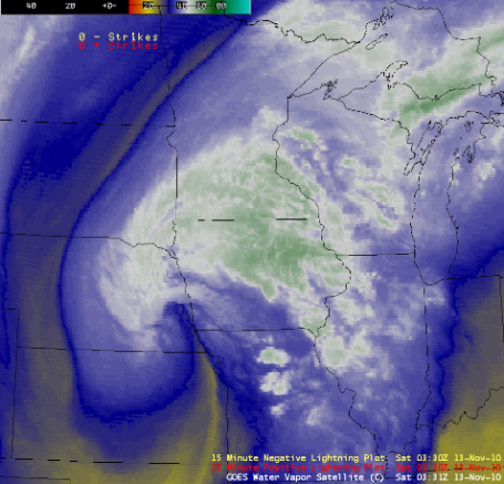
Anatomy Of A Snowstorm. The University of Wisconsin CIMSS blog has a terrific satellite loop showing the evolution of yesterday's snowstorm. It took a perfect track for heavy snow, from Des Moines to Eau Claire - far enough east to prevent warm air from mixing in from the east and changing precipitation over to rain/sleet.
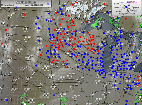
Sunday Surface Map. Don't panic - the red dots symbolize areas of "IFR" flight rules with low visibilities and low ceiling (cloud heights). The snow has already shifted north into Ontario and I don't expect any additional accumulation today.
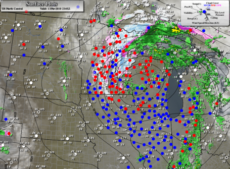
Flashback. Here was Saturday afternoon's surface map - showing a relatively narrow (north-south oriented) band of heavy snow setting up over eastern and portions of central Minnesota. Take a careful look - warm air had completely wrapped around the storm (it was raining over most of Lake Superior!) with just enough cold air in place over Minnesota for mostly-snow. A snowstorm is a fragile dance, a delicate balance of cold air and southern moisture. Too much of either ruins the recipe and either a). pushes the track too far south/east (in the case of too much cold air) or b) sparks a changeover to rain/ice - which kills final snowfall amounts (in the case of too much southern moisture/warmth). Yesterday - for a rare, fleeting, 18 hours - the balance was PERFECT over the Twin Cities. Meanwhile St. Cloud picked up less than an inch. 1-12", over the span of 60 miles. This is why we have gray hairs - if we have any hairs at all left on the tops of our pointy little heads.
Paul's Conservation Minnesota Outlook for the Twin Cities and all of Minnesota:
TODAY: Mostly cloudy with flurries - no additional accumulation. Much better travel. Winds: W 15. High: 38
SUNDAY NIGHT: Flurries wind down, partial clearing late. Low: 25
MONDAY: Partly sunny and dry. High: 37
TUESDAY: Mostly cloudy - melting snow by afternoon. High: near 40
WEDNESDAY: Clouds, few flurries possible. High: 37
THURSDAY: Cool sun, light winds - good travel conditions. High: 32
FRIDAY: Getting sunnier, cool wind. High: 35
SATURDAY: More clouds than sun, still quiet. High: 36
Digging Out
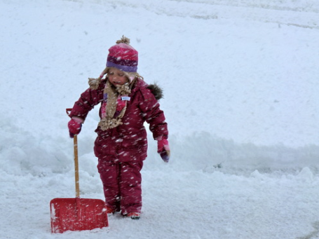
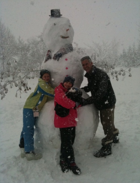
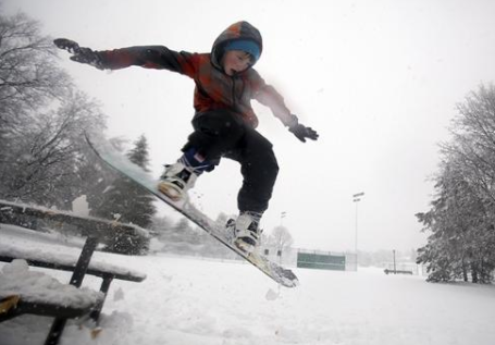
Dear diary: it actually "snowed" in the Twin Cities yesterday; a big, heaping pile of cold, cement-like slush, a cool 8-12" of white frosting, the biggest pre-Thanksgiving snow in 19 years. We got a little of our Minnesota Mojo back this weekend.
Fire up the snow-blowers, snowmobiles and sleds - today will be a great day to play in the snow; travel conditions slowly improving as temperatures thaw into the mid & upper 30s, roads in pretty good shape for Monday's commute. It was (for many) "The Perfect Storm", coming on a weekend, when most of us could snub the new & improved Crosstown Expressway and enjoy the winter wonderland emerging outside our windows. There's nearly 1.5" of liquid water tied up in that snow-pack, heavy enough to snap tree limbs - but snow lovers finally have something to celebrate.
"Americans are too preoccupied with inches, and technology doesn't allow us to get that precise," my favorite professor warned. He suggested the "nuisance/plowable/crippling" scale which I use to this day.
No more big storms are brewing, but long-range models hint at a cold smack in time for Thanksgiving week, highs stuck in the 20s to near 30. So much for Indian Summer.
No comments:
Post a Comment