INCHES LOCATION ST COUNTY TIME
------ ----------------------- -- -------------- -------
11.00 EDEN PRAIRIE MN HENNEPIN 1030 AM
11.00 1 SSW WYOMING MN CHISAGO 0400 PM
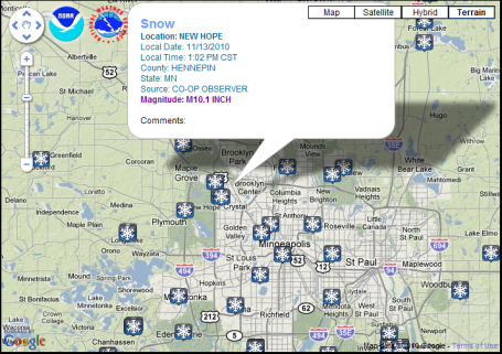
10.10 NEW HOPE MN HENNEPIN 0102 PM
10.00 MONTGOMERY MN LE SUEUR 1130 AM
STILL SNOWING.
10.00 3 N FOREST LAKE MN CHISAGO 0104 PM
SO FAR
10.00 SW BURNSVILLE MN DAKOTA 0216 PM
9.80 CHANHASSEN MN CARVER 0510 PM
9.50 NEW MARKET MN SCOTT 0258 PM
9.40 RUSH CITY MN CHISAGO 0445 PM
9.40 RUSH CITY MN CHISAGO 0510 PM
9.20 ST LOUIS PARK MN HENNEPIN 0605 PM
9.00 3 NNW MINNEAPOLIS MN HENNEPIN 1243 PM
STORM TOTAL SO FAR
9.00 CHISAGO CITY MN CHISAGO 0301 PM
8.90 2 W PRIOR LAKE MN SCOTT 1239 PM
8.60 MADELIA MN WATONWAN 1025 AM
8.50 1 SE CHASKA MN CARVER 0112 PM
8.50 EDINA MN HENNEPIN 0505 PM
8.30 5 SE ELK RIVER MN ANOKA 0148 PM
8.20 WACONIA MN CARVER 0426 PM
TOTAL SO FAR
8.00 WINNEBAGO MN FARIBAULT 1010 AM
STILL SNOWING LIGHTLY.
7.50 2 ESE MINNETONKA MN HENNEPIN 1115 AM
GLEN LAKE AREA.
7.30 BLOOMINGTON MN HENNEPIN 1248 PM
7.00 GLENCOE MN MCLEOD 0150 PM
7.00 WOODBURY MN WASHINGTON 0335 PM
6.80 2 NNE RUSH CITY MN CHISAGO 1030 AM
6.50 1 ENE INVER GROVE HEIGH MN DAKOTA 1115 AM
6.50 2 SSW CAMBRIDGE MN ISANTI 1239 PM
6.50 WOODBURY MN WASHINGTON 0505 PM
6.20 ST PAUL MN RAMSEY 0505 PM
6.00 JANESVILLE MN WASECA 1027 AM
6.00 5 S FARMINGTON MN DAKOTA 0505 PM
5.50 LEWISVILLE MN WATONWAN 1015 AM
STILL SNOWING.
5.40 CHAMPLIN MN HENNEPIN 0335 PM
5.00 1 E CUMBERLAND WI BARRON 0205 PM
4.70 5 NE FOREST LAKE MN CHISAGO 1245 PM
4.50 2 N ELKO MN SCOTT 0139 PM
IN PAST 6 HOURS...7.5 ON GROUND
4.00 CLAYTON WI POLK 1230 PM
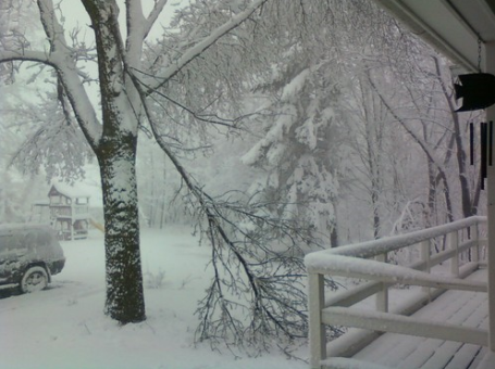
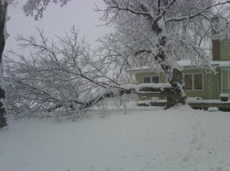
FOUR INCH BRANCH DOWN DUE TO WEIGHT OF SNOW.
LIGHT SNOW STILL FALLING AT TIMES.
4.00 MORA MN KANABEC 0211 PM
3.80 11 NE WARMAN MN KANABEC 0150 PM
STILL SNOWING.
3.00 1 ENE INVER GROVE HEIGH MN DAKOTA 1237 PM
SNOW DEPTH 8.5
3.00 WNW FARIBAULT MN RICE 0112 PM
1.70 7 S HILLMAN MN MORRISON 0313 PM
1.00 7 S HILLMAN MN MORRISON 0130 PM
MAINLY ON GRASSY SURFACES.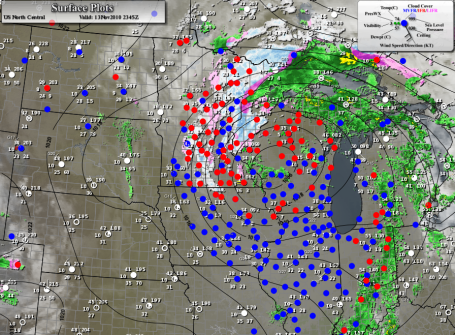
A Real Snowstorm! Residents of the Twin Cities were starting to wonder if we would ever see a "real storm" here - it's been a long time, snow has come in dribs and drabs in recent years, 2003-2004 the last "above average" winter with over 66" of snow. Well, Saturday we got a subtle (yet blunt) reminder that La Nina is kicking in, a cooling phase in the Pacific that tends to correlate with snowier winters across the Upper Midwest. Will this continue? No idea - no more big storms in sight between now and Thanksgiving. Today's storm (which took a perfect track - for snow - from Des Moines to Eau Claire) continues to wrap moisture around it's counterclockwise circulation, but the north-south bands of snow are weakening - little additional accumulation expected.
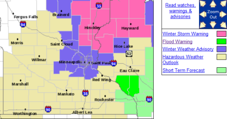
Storm Downgraded. The NWS has lifted the warnings - the metro now under an advisory (but heavy snow continues to fall from near Hinckley to Duluth). Temperatures will dip just below the freezing mark - some (untreated) secondary roads will become very icy by daybreak.


Dreaded Dry Tongue. Every major storm eventually pulls dry (desert) air into its circulation, what meteorologists lovingly refer to as the "dry tongue" - a surge of dry air that pushes in from the south/southwest - thinning out the clouds and lightening up snowfall rates. The 10 am visible satellite shows dry air getting tangled up in the storm's circulation, cutting off the heavy precipitation across southeastern MN and southwestern WI. The "deformation zone", the axis of heaviest snow - is setting up right over the Twin Cities - before the day is through many suburbs will pick up that 10-12" that was predicted. Snow lovers are grinning from ear to ear - anyone who has to drive in this stuff is probably dreading the next few hours.
No comments:
Post a Comment