Saturday, November 13, 2010

Snow Slowly Tapers (totals range from 6-12")

Storm Headline Update (1:40 pm)

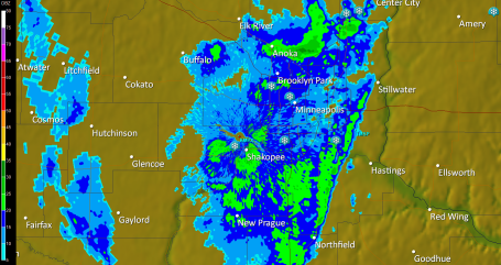
1). All snow - the lowest mile of the atmosphere definitely cold enough for snow - no changeover to rain/sleet.

2). Deformation zone axis directly above MSP: heaviest snow bands will linger over the MSP metro area through the afternoon, but snowfall rates are diminishing - the heaviest accumulations are behind us now

3). Snow will slowly decrease in intensity by late afternoon/evening, but by then many spots will have at least 8-10", a few suburbs may have closer to a foot.

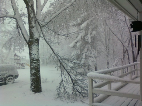
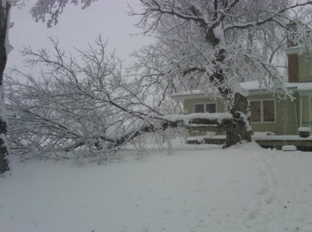
4). Heavy, wet, cement-like snow will linger into mid afternoon. With temperatures close to freezing aloft: a). snowflakes are HUGE, and b). the risk of downed trees/powerlines is very high as snow continues to pile up. Consider cleaning the snow off smaller trees and shrubs.

5). Latest NAM/WRF prints out 1.2" liquid - which translates into a foot of snow. Factoring in some melting on contact and a snow:liquid ratio closer to 8:1 - you wind up with snow totals of 8-12" across most of the metro area, but less than 5" south/east of St. Paul.

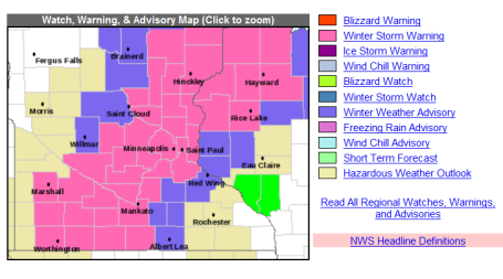
Winter Storm Warnings. NOAA has more on our early snowstorm here. This may be the "Perfect Storm", coming on a Saturday, when many Minnesotans don't have to worry about a white-knuckle commute. Snow lovers finally have something to celebrate - Sunday should be ideal to get out and play in the snow.

Slow - But Moving. This Google traffic map (1:20 pm) shows slow travel conditions throughout the metro (the best conditions are in the St. Paul suburbs, where snowfall hasn't been quite as heavy as over the western suburbs of the Twin Cities). Travel conditions will get worse by late afternoon and evening as darkness falls, and temperatures slip just below 32 F - causing wet/slushy roads to become ice-covered overnight.

Biggest Pre-Thanksgiving Snowstorm Since 1991. If we pick up at least 6.5" (likely) from this storm at KMSP, this storm will go down into the record books as the biggest snowstorm (pre-Thanksgiving) in 19 years. Hey, we were due. I say that going into every winter, but today the law of averages finally caught up with us.

Winter Wonderland. This photo was taken in Excelsior, where the heavy, wet, almost cement-like snow brought down tree limbs. Email your snow photos to post@snowstrib.posterous.com
 
Heavy Snow Axis Stalled Over MSP. Doppler radar (1:23 PM) shows a north-south oriented band of moderate snow temporarily stalled over the  Twin Cities - snow falling at the rate of 1/2" hour, but the heaviest snows will be winding down through the afternoon - a few towns will wind up with close to 12". Amazing, especially considering we were all walking around in shirtsleeves Wednesday with highs near 70. Talk about a rude reality check!

Dreaded Dry Tongue. Every major storm eventually pulls dry (desert) air into its circulation, what meteorologists lovingly refer to as the "dry tongue" - a surge of dry air that pushes in from the south/southwest - thinning out the clouds and lightening up snowfall rates. The 10 am visible satellite shows dry air getting tangled up in the storm's circulation, cutting off the heavy precipitation across southeastern MN and southwestern WI. The "deformation zone", the axis of heaviest snow - is setting up right over the Twin Cities - before the day is through many suburbs will pick up that 10-12" that was predicted. Snow lovers are grinning from ear to ear - anyone who has to drive in this stuff is probably dreading the next few hours.

High Water Content Snow. Stating the obvious: there is an incredible amount of water tied up in this snow. The usual snow:liquid ratio is 10:1, but today it may be closer to 8:1, even 6:1. The closer the temperatures in the lowest mile of the atmosphere is to freezing, the larger the flakes (supercooled water droplets cause these huge flakes to stick together into mega-flakes. Bottom line: I just "shook" the shrubs on either side of our front door - trying to keep them from snapping off - you may want to brush some of the snow off of tree limbs or risk some damage in the hours ahead.


Snowfall Reports from the National Weather Service as of 1:17 pm Saturday:

PRELIMINARY LOCAL STORM REPORT...SUMMARY
NATIONAL WEATHER SERVICE TWIN CITIES/CHANHASSEN MN
111 PM CST SAT NOV 13 2010

..TIME...   ...EVENT...      ...CITY LOCATION...     ...LAT.LON...
..DATE...   ....MAG....      ..COUNTY LOCATION..ST.. ...SOURCE....
            ..REMARKS..

0104 PM     SNOW             3 N FOREST LAKE         45.32N 92.98W
11/13/2010  E10.0 INCH       CHISAGO            MN   CO-OP OBSERVER

            SO FAR

0104 PM     SNOW             BLOOMINGTON             44.83N 93.32W
11/13/2010  M6.4 INCH        HENNEPIN           MN   TRAINED SPOTTER

            SO FAR

0102 PM     SNOW             NEW HOPE                45.04N 93.39W
11/13/2010  M10.1 INCH       HENNEPIN           MN   CO-OP OBSERVER

1248 PM     SNOW             BLOOMINGTON             44.83N 93.32W
11/13/2010  M7.3 INCH        HENNEPIN           MN   TRAINED SPOTTER

1245 PM     SNOW             5 NE FOREST LAKE        45.33N 92.91W
11/13/2010  M4.7 INCH        CHISAGO            MN   CO-OP OBSERVER

1243 PM     SNOW             3 NNW MINNEAPOLIS       45.00N 93.29W
11/13/2010  E9.0 INCH        HENNEPIN           MN   TRAINED SPOTTER

            STORM TOTAL SO FAR

1239 PM     SNOW             2 SSW CAMBRIDGE         45.54N 93.24W
11/13/2010  E6.5 INCH        ISANTI             MN   TRAINED SPOTTER

1237 PM     SNOW             1 ENE INVER GROVE HEIGH 44.83N 93.04W
11/13/2010  M3.0 INCH        DAKOTA             MN   TRAINED SPOTTER

            SNOW DEPTH 8.5

1230 PM     SNOW             CLAYTON                 45.32N 92.17W
11/13/2010  M4.0 INCH        POLK               WI   TRAINED SPOTTER

            FOUR INCH BRANCH DOWN DUE TO WEIGHT OF SNOW. LIGHT SNOW
            STILL FALLING AT TIMES.

1155 AM     SNOW             EDINA                   44.89N 93.36W
11/13/2010  M7.9 INCH        HENNEPIN           MN   TRAINED SPOTTER

1155 AM     SNOW             BLOOMINGTON             44.83N 93.32W
11/13/2010  M5.0 INCH        HENNEPIN           MN   NWS EMPLOYEE

            5 INCHES ON THE DRIVEWAY. 7.5 INCHES OTHER SURFACES.

1135 AM     SNOW             HASTINGS                44.73N 92.85W
11/13/2010  M3.1 INCH        DAKOTA             MN   TRAINED SPOTTER

1130 AM     SNOW             MONTGOMERY              44.44N 93.58W
11/13/2010  M10.0 INCH       LE SUEUR           MN   CO-OP OBSERVER

            STILL SNOWING.

1130 AM     SNOW             2 SW PRIOR LAKE         44.71N 93.46W
11/13/2010  M2.2 INCH        SCOTT              MN   TRAINED SPOTTER

            STORM TOTAL 8.5 SO FAR

1115 AM     SNOW             1 ENE INVER GROVE HEIGH 44.83N 93.04W
11/13/2010  M6.5 INCH        DAKOTA             MN   TRAINED SPOTTER

1115 AM     SNOW             2 ESE MINNETONKA        44.90N 93.47W
11/13/2010  M7.5 INCH        HENNEPIN           MN   TRAINED SPOTTER

No comments:

Post a Comment