
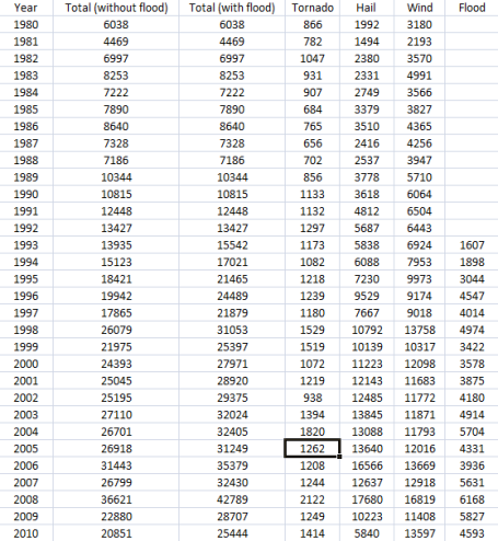
Troubling Trends. Data from NOAA, SPC (Storm Prediction Center) and NCDC (National Climatic Data Center) show a steady increase in severe storms(tornadoes, hail, high winds) across the USA since 1980. The first decade of the 21st century produced 3 to 5 times more severe storm reports than the 1980s. Flood reports have been tabulated since 1993: data shows an average of 3,358 floods/year across the USA from 1993-1999. Since 2000 the average number of yearly floods has risen to 4,750. That's a 41% in flash floods from one decade to the next. Again, it may not be a long enough data set to reach profound conclusions, but it's pretty hard to ignore the fact that severe flooding reports seem to be on the rise. Thanks to St. Cloud State University Meteorology student D.J. Keyser for helping me tabulate these numbers into a spreadsheet.
Mystery Man. So I'm in L.A. - minding my business, having a nice stroll down the Sunset Strip with my wife, and along comes this CRAZY GUY!! Yes, I miss Mr. Magers. He is truly one-of-a-kind.


What Extreme Winds Can Do. This remarkable YouTube footage shows the roof of an apartment complex being ripped off during last Tuesday's extreme wind storm, the same storm that deepened to 28.21" over Bigfork, MN produced sustained winds of 60+ mph from Minnesota across the Great Lakes, knocking out power to hundreds of thousands of people. It was the strongest storm ever observed between the Rockies and the Appalacians.

It Was The Hottest Day In November History. On Thursday afternoon San Diego recorded a hair-curling high of 100 F, 28 degrees above average, the first 100-degree reading since September 25, 1989. More details here.
Paul's Conservation MN Outlook for the Twin Cities and all of Minnesota:
TODAY: Deer Hunting Firearms Opener. Bright sun, breezy and pleasant. SW 10-15. High: 55
SATURDAY NIGHT: Clear and seasonably cool. Low: 35
SUNDAY: Plenty of sun, touch of Indian Summer! High: 58-60
MONDAY: Still mild, high clouds increase, feels more like mid October. High: near 60
TUESDAY: More clouds, PM drizzle? High: 56
WEDNESDAY: Mostly cloudy, cooling off a bit. high: 51
THURSDAY: Cold rain develops, mix north/west? High: 44
FRIDAY: Windy and colder - wet snow tapers to flurries. Some slush possible close to home. High: near 40
The Deer Are Nervous
"Please don't call this winter." Stephanie Skjervold, a personal banker at Wells Fargo in Excelsior, had a pleasantly defiant look on her face. "Winter is December through February. Give winter its due, but don't let it spill over into November or March." Why, I inquired? "Otherwise winter takes up half the year & it's just unbearable." Got it. The power of positive thinking - or maybe "denial"?
Stephanie (and any other winter-weary inhabitants of this fine state) won't have a thing to worry about through Tuesday. A bubble of high pressure treats us to a sun-scrubbed sky today, a light southerly breeze tugs the mercury close to 60 in the metro by Monday, almost 15 degrees above average. To recap: September lingered into most of October; now October is pushing November out of the way. Makes perfect sense to me.
No snow on the ground up north for tracking that trophy buck this year. A colder front sparks a little drizzle by Tuesday. A secondary storm rippling north along that surge of Canadian air spreads a cold rain into town Thursday. That rain changes to wet snow by Friday morning - a couple inches of slush near the metro? Gulp. Enjoy one last fling of Indian Summer!


That's a funny Pix of Mr Major. Did he know you were in town?
ReplyDelete