Weather Headlines:
1). No major travel problems today. The sun may even peek through, the proverbial calm before the storm.
2). If you can take off first thing tomorrow (especially if you're driving south/east) you should be ok.
3). Conditions worsen (from west to east) Wednesday afternoon. Enough warm air may wrap into the storm for a period of ice/sleet before a changeover to snow by late afternoon.
4). There is a significant risk of blizzard conditions across parts of the metro between 3 pm and 9 pm tomorrow. Winds may reach 30-40 mph, a thin layer of ice under (rapidly) accumulating snow.
5). The latest guidance is hinting at 2-5" of snow for the metro (closer to 5" if we don't see as much sleet/rain as I'm expecting). Parts of central MN may pick up 4-8" with over 10-12" closer to Duluth.
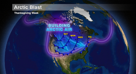
6). Snow tapers to flurries Thanksgiving Day with little additional accumulation in the metro area. The big story by Thursday will be the cold - temperatures stuck in the teens with subzero wind chills. Lows may dip below zero Thursday night as the wind chill dips to -20 F. Think twice about traveling Thursday, especially after dark. Running out of gas or sliding into the ditch could be more than just a minor inconvenience - it could be life-threatening.
7). The sun should be out Friday, bitter cold but dry, suitable for shopping. Thank you Amazon.com.
8). I still don't see any post-Thanksgiving travel headaches - just a little light snow over far northern MN late Sunday, but no major accumulations of snow or ice after Thursday. Getting home should be a lot easier than getting to your destination late tomorrow.
Giving Thanks. Yes, the weather will be a challenge (especially Wednesday afternoon into Thursday night). Rain, ice, snow and cold, in pretty much that order. For about 48 hours it will feel like the depths of late January, not late November. But with planning & preparation we'll get through this nasty spell, safe and sound with the people we care most about. Yes, in spite of the oncoming Arctic Express we have much to be thankful for...
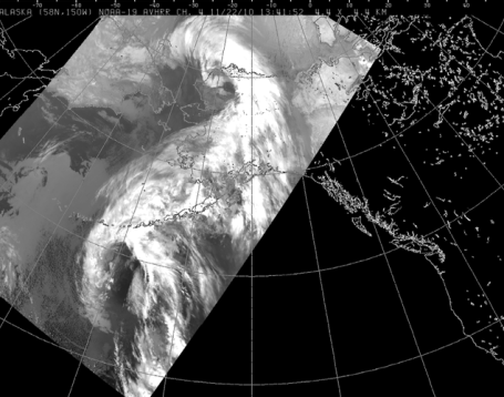
Rain - in Fairbanks, Alaska? For only the second time in 100 years it has rained (hard) in Alaska's icy interior, 2/10ths of an inch of rain at least report. Old-timers are scratching their heads - temperatures 30-40 degrees warmer than normal with as much as .60" rain west of Fairbanks. Numbing air that SHOULD be anchored over Alaska has been displaced south and east - heading relentlessly toward Minnesota. ETA: 36-48 hours away. The Fairbanks Daily News has more on this bizarre meteorological event
here.
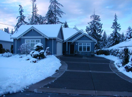
Winter Wonderland. Bob Blasky lives on Vancouver Island, west of Vancouver, British Columbia. He woke up to a cool 6-8" of snow Monday morning and shared the end result. One of these days I'm going to invest in a heated driveway. Now there's some technology I can use.
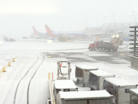
An Icy Omen? The Pacific Northwest has been temporarily paralyzed by snow, ice and bitter cold. Flights into Seatac International were delayed, in some cases canceled by near white-out conditions. Photo courtesy of
TwitPic.
(Premature) Arctic Blast. Yes, it's a little early to be tracking hair-curling, battery-draining air south of the border. By the end of the week it will feel more like late January than late November. The good news: this Arctic intrusion will be BRIEF. By next Sunday highs will rebound back up to freezing, close to average for late November. Deep breaths.
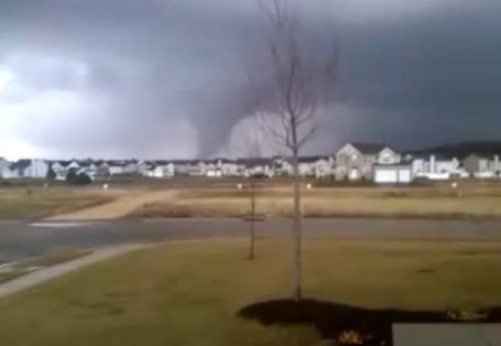
Late November Tornado Swarm. Click
here to see some pretty amazing YouTube footage of the large tornado (possibly an EF-2) that struck Loves Park, Illinois around 3:15 pm Monday afternoon. Large, violent tornadoes in late November? Unusual to say the least.
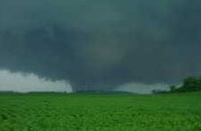
Rockford Wedge. This "wedge" tornado was so wide it didn't even resemble a classic tornado funnel. Just by appearance this appears to be an EF-2, possibly even an EF-3 or EF-4, part of the same swarm of tornadic storms that raced into southern Wisconsin, with touchdowns between Madison and Milwaukee.
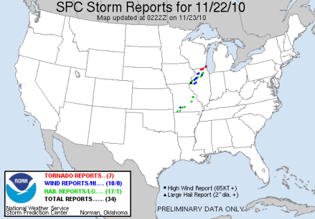
Tornado Update. As of Monday evening at least 7 separate tornadoes had been reported, most between Rockford and Milwaukee, with at least 3 injuries. But I have a feeling the final number will be somewhere between 1 and 2 dozen. Typical for April or May, but on November 22? The complete SPC damage report is
here.
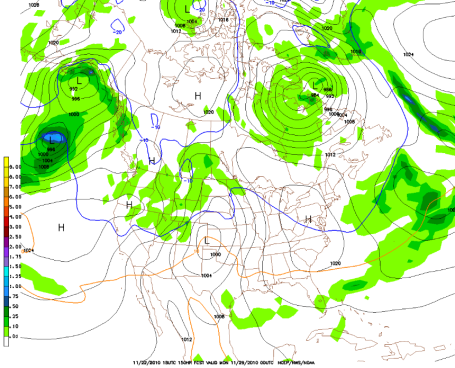
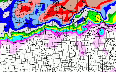
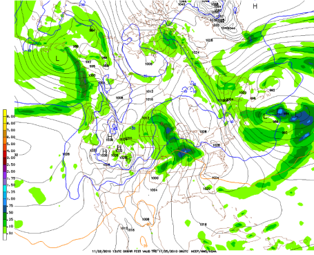
Latest Snowfall Prediction. Notice how everything has shifted north by 50-75 miles in the last 24 hours, a (slight) northward jog in the storm track taking the heaviest amounts of snow north of St. Cloud and Lake Mille Lacs, where 4-8" may still fall by Thursday afternoon. This GFS prediction is for TOTAL SNOWFALL between now and midnight Friday night. Some 12-15" amounts are still expected over the northern third of MN - from the Red River Valley and Bemidji to Duluth and the MN Arrowhead.
"Snow Burst." The best chance of heavy precipitation will come late afternoon Wednesday into the overnight hours Wednesday night. Precipitation may start as a mix of rain/ice/snow, then change over to mostly snow. I'm expecting at least a quick couple of inches, maybe as much as 4-5" over the far north/east metro before flurries taper off on Thanksgiving.
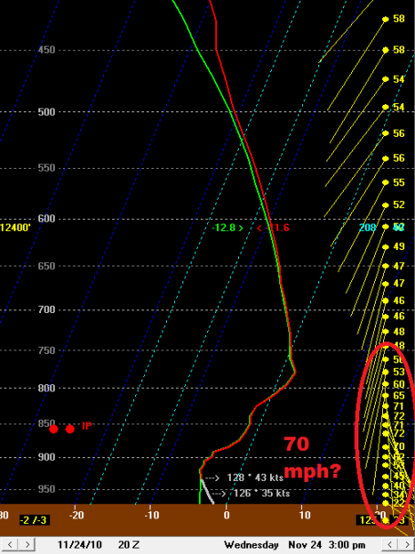 Diagnosis: Blizzard Potential Wednesday PM Hours
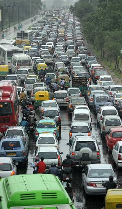
. The predicted "sounding" (atmospheric cross-section) 3 pm tomorrow is showing 70 mph winds within 2,000 feet of the surface. That could be a problem - southeast winds may reach sustained winds over 30-35 mph. at times - creating near white-out conditions for the drive home tomorrow. Have a Plan B - leave yourself PLENTY of extra time to reach your destination. I think you'll be OK morning hours, but after 2 pm all bets are off. It could be VERY rough out there with windblown sleet/freezing rain changing to heavy snow.
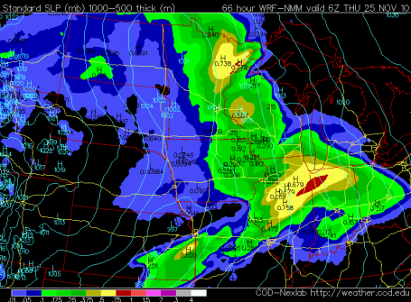
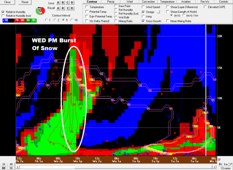 Tracking A Snow "Burst"
. This is a product from BUFKIT, an amazing NWS program that helps meteorologists determine the potential for snow/ice/rain. In this case we're looking at a time line (now is on the right - the graph reads from right to left - I know, a bit counter-intuitive). The area I've circled shows intense upward motion (and ripe conditions for dendritic ice crystals about 10,000 feet above the ground between noon and 8 pm tomorrow. That's why I'm thinking we may see a period of heavy ice (sleet and freezing rain) changing to heavy wet snow by the dinner hour. The timing is tricky, but I think the late PM hours tomorrow may be a real mess.
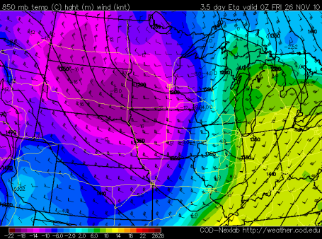
Very Cold Turkey. Just about the time you're washing dishes, digesting your turkey feast, maybe getting into a minor argument with your favorite Mother In Law - Arctic air will come surging into Minnesota on icy west/northwest winds. Thursday night will be the coldest night - a good chance of subzero lows north/west of the Twin Cities, with wind chills dipping to -20 F. at times. You will NOT want to get stuck outside Thursday night.
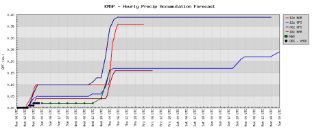
Not Much Continuity. Meteorologists like to see the computer models agree on a common solution. As you can see that is NOT the case with Wednesday's predicted burst of snow. Some of the models print out only .15" (which might turn into a slushy inch or two). But if we get closer to .35" or .40" of liquid precipitation the final snowfall tally could be closer to 4 or 5" (especially northern suburbs). I want to see a few more computer runs - but I still think MOST roads in and around the metro area will be wet on Wednesday. But a rapid temperature drop Wednesday night into Thanksgiving will turn wet/slushy roads to ice, and at least 2-3" of snow may accumulate on top of that icy layer. Thankfully the worst travel conditions will probably come late Wednesday night into Thursday - when most people are already at their Thanksgiving destinations.
Snowy "Burst". The most reliable model, the NAM/WRF, brings a brief, heavier burst of wet snow across the state Wednesday night - the heaviest amounts possible from 8 pm Wednesday evening into the wee hours of the morning Thursday. 2-5" of (icy) snow may accumulate in the metro, with heavier, 4-8" amounts over central MN, as much as 10-12" over far northern Minnesota. It looks like mostly rain for Iowa, southern Wisconsin and the Chicago area. If the storm tracks farther south the region of heavier snow could also dip farther south, closer to the MSP metro area. But right now it appears the heaviest snow amounts will stay north of the Twin Cities. Stating the obvious: we'll be watching the computer runs very closely over the next 48 hours.
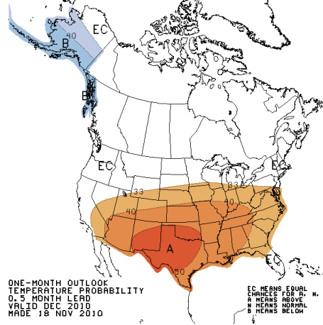
December Outlook. The Climate Prediction Center believes that (in spite of a moderate La Nina cooling of Pacific Ocean water) the trend should be toward milder-than-average temperatures over much of the USA in December, a mild bias extending into far southern Minnesota. We'll see. But the atmosphere does have an uncanny ability to "even things out" - unusually cold spells tend to be followed by unusually mild periods. Place your bets. To see the full suite of long-range climate predictions, from the 3-7 Day Outlook to the Seasonal Outlook for the entire winter (into the first half of 2011) click
here. Remember, it's more of a "trend" than an actual forecast. Translation: buyer beware.
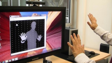
Windows 7 Gets The "Minority Report" Treatment Using Kinect. Talk about life imitating art, in this case the movie "Minority Report", starring Tom Cruise. According to gizmag.com "
In the 2002 movie Minority Report, part of the “way out there” 2054 technology was a computer system that Tom Cruise navigated his way through via arm and hand gestures. That technology – minus the holograms – has now officially arrived 44 years ahead of schedule, thanks to the design team at tech firm Evoluce. With support from Microsoft, the company has created prototype software which allows Microsoft’s Kinect gesture-based video gaming platform to control Windows 7 applications. PC-users will likely soon be able to “swim” through Google Earth images, write on-screen messages in the air, and surf the Internet without cramping their mousing hand." Pretty amazing - the complete article is
here.
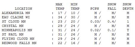 "Nuisance Snow."
 Officially a tenth of an inch of snow fell at MSP Monday (what meteorologists euphemistically refer to as a "coating"). Nearly half an inch of snow fell at St. Cloud (where there is 1" on the ground). Highs ranged from a chilly 17 at Alexandria to 23 in St Cloud, 31 in the Twin Cities and 34 at Eau Claire, WI.
Paul's Conservation MN Outlook for the Twin Cities and all of Minnesota:
TUESDAY: Mostly cloudy, good travel conditions statewide. Winds: NW 8-13. High: 23
TUESDAY NIGHT: Patchy clouds, few flurries. Low: 17
WEDNESDAY: Wintry mix of rain, sleet and some wet snow changes to snow. No big problems for AM commute but PM commute could be a slushy, icy (windy) mess. High: 33 (falling after 2 pm)
WEDNESDAY NIGHT: Mix changes to all snow, couple inches of accumulation possible. Low: 17
THANKSGIVING DAY: Windy and much colder - snow tapers to flurries, 2-5" totals metro area, 10-15" up north (where blowing/drifting will be a problem). High: 19 (coldest Thanksgiving Day since 1989?)
THURSDAY NIGHT: Clearing and bitter - dangerously cold statewide. Low: near 0 (wind chills dipping to -20 at times).
FRIDAY: Numb & number. Good shopping weather with some sun returning. High: 18
SATURDAY: More clouds than sun, few flakes - good travel weather. High: near 30
SUNDAY: Mostly cloudy, couple inches snow far north? Milder in the metro (little or no accumulation). high: 34
MONDAY: Colder wind, few flurries. High: 31
Thanksgiving Mercy?
My heart rate is coming back down to double-digits; the latest maps not quiet as menacing as they were last weekend. We're still expecting snow and numbing January cold by the end of the week, but a slight, 50-75 mile northward jog to the storm track should mean "plowable" snow for St. Cloud & Brainerd, as much as 10-15" from the Red River Valley and Bemidji to Duluth. But Wednesday's storm may inhale enough warm air north for a wintry mix Wednesday here (with mainly wet roads in the metro), ending as 2-5 inches of snow Wednesday night and Thursday morning. the best chance of 5" will come from the far northern suburbs (Isanti, Cambridge and Princeton) to St. Cloud, less than 2" south of MSP.
We're not out of the woods just yet, but it's looking better for (metro) travel Wednesday, with mainly wet roads close to home. Cold exhaust on the backside of this storm will whip up 30 mph winds Thanksgiving Day, creating near white-out conditions up north. Snow will be light & powdery, vulnerable to blowing & drifting.
Good news: your Christmas shopping odyssey to the mall Friday should be just fine: plenty cold but dry. And a "zonal" flow of Pacific air should boost the mercury above 32 F. by Sunday. Only in Minnesota could the locals get excited to witness "freezing". We've seen worse. Click the weather blog for more info.
 Nuisance Snow Up North Late Sunday
. I don't see any ticking time-bombs getting home next weekend, some sun on Saturday, clouds increasing Sunday as a weak storm approaches from the Denver area - maybe a period of very light snow over far northern MN late Sunday and Sunday night capable of an inch or so.
A Warning On Climate Change From 2 Outgoing Republican Congressmen. The writing is on the wall, or so says 2 Republican Congressmen who believe their party should address the issue head-on. In a Washington Post op-ed, former Rep. Sherwood Boehlert (R-NY) wrote: "
What is happening to the party of Ronald Reagan? He embraced scientific understanding of the environment and pollution and was proud of his role in helping to phase out ozone-depleting chemicals. That was smart policy and smart politics. Most important, unlike many who profess to be his followers, Reagan didn't deny the existence of global environmental problems but instead found ways to address them." Rep. Bob Inglis (R-SC) used the analogy of a sick child to drive home his point, "
Your child is sick," he said. "Ninety-eight doctors say treat him this way. Two say no, this other way is the way to go." By taking the minority viewpoint that carbon emissions are not a problem, "you're taking a big risk with those kids," he said. The complete article is
here.
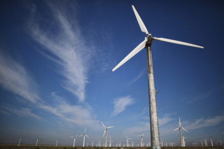
Study Links Lower Carbon Emissions To Recession. The scientific journal Nature Geoscience reports a drop in global carbon emissions of 1.3% from 2008 to 2009, the first time numbers have gone down in annual greenhouse gas emissions since the last 90s. The worldwide recession is probably to blame, according to their calculations. USA Today has the full report
here.
No comments:
Post a Comment