* Winter Storm Warning for the metro - Blizzard Warnings posted just south/west of MSP for white-out conditions later today.
* Snow gets heavier/steadier as the day goes on - sustained winds of 20-35 mph create white-out conditions, especially outside the metro.
* Snow accumulates at the rate of 1-2"/hour at times during the morning and midday hours, gradually tapering to flurries tonight..
* How much? A foot at the low end, closer to 2 feet at the upper end. It will be nearly impossible to measure, with winds gusting over 30 mph. My semi-educated hunch: 15-20" for much of the metro by the time snow tapers late tonight.
* Consider waiting until tomorrow afternoon to hit the roads - MnDOT should have most of the major roads dug out by afternoon, but I'm expecting some 2-5 foot drifts; it's going to take awhile for the secondary roads and side streets to get cleared.
* Wind Chill Alert: north/northwest winds of 20-40 mph will make it FEEL like -20 to -35 tonight - -significant risk of frostbite and hypothermia through Monday morning. Consider checking in on older friends, neighbors and family to make sure their homes/apartments are staying warm enough.
Top Snowstorms In The Twin Cities. Will we see at least 16.7" today? It may be close, but I have a (strong) hunch we're going to be in the top 5 snowfalls before the day is through. My hope is that we will not exceed the Halloween Superstorm tally of 28.4". No - I don't think it's going to be quite that much. But 20"? I wouldn't rule it out. More data on snowfall extremes here.
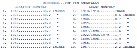
Top 10 December Snowfalls. There's a (good) chance we'll make this list before the month is through. Click here to see more information from the MN State Climate Office.
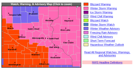
Winter Storm Warning - Blizzard Warning. The farther south/west you travel away from the MSP metro area, the worse travel conditions will be today. White-out conditions are possible, the local NWS has issued blizzard warnings south/west of Shakopee, Litchfield and Willmar.
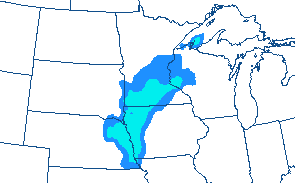
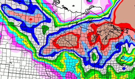
Blizzard Potential. NOAA's HPC Winter Impact Graphics show a significant probability of blizzard conditions across southern and central Minnesota by mid afternoon today.
Snowy Bulls-Eye. If anything the snow looks even more impressive than it did Friday. The greatest amounts (16-20") are forecast to set up from the Twin Cities south/east toward Rochester, Eau Claire and Menomonie, WI. Brainerd may only pick up 2-4", same up at Alexandria and Wadena, with 10-15" for St. Cloud.
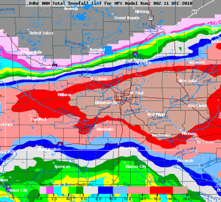
"Crippling"? Yesterday I went out on a (big) limb and suggested that this may be more than just "plowable" - it may, in fact, turn into a "crippling" snowstorm for the Twin Cities and much of southeastern MN and western WI. It's not a sure thing (yet), but guidance continues to increase the predicted snowfall amounts - the heaviest bands setting up right over the metro. At the low end: 12", but if the storm stays on track some 18-22" amounts are possible very close to home. Good luck measuring the snow - 20-35 mph winds will whip up huge drifts by afternoon and evening.
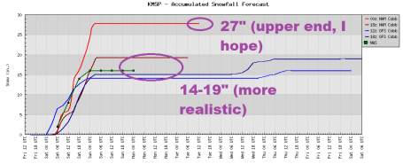
Running Up The Score. It's getting to the point where I'm afraid to check the latest model run. The Friday 00z run prints out 27" of snow (NAM), the other models clustering around 14-19". Any way you look at it - it's going to be a big number piling up on your driveway today.
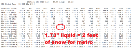
Snow Lovers Rejoice (everyone else grin and bear it). The latest NAM/WRF model prints out 1.73" liquid. Assuming a 15/1 snow/rain ratio (which may be very conservative, at 10 degrees that number is closer to 25/1) that equates into 2 feet of snow. We'll see...
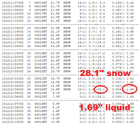
Another Run. Here is an hour-by-hour, blow-by-blow prediction for MSP, showing 28.1" of snow by 10 pm tonight.
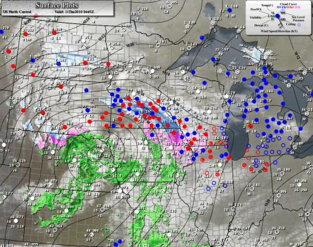
Intensifying Storm. Minnesota's biggest storms track just south of the state, tapping Canadian air and moisture from the Gulf of Mexico. Today's storm track will go from Omaha to Des Moines, La Crosse to the Wisconsin Dells, the heaviest snow bands setting up 200-250 miles north of the track, pretty much right over the metro area. The latest surface map is here.
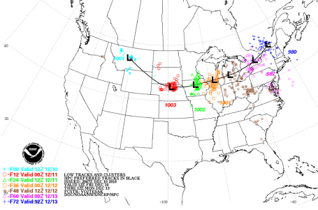
The Perfect Storm. Trite, cliche, and true. The projected storm track will take the (intensifying) storm just south of Minnesota, moving just slow enough to tap moisture from the Gulf of Mexico, wrapping all the way around the storm (approaching from the north/northeast by afternoon and evening). That wrap-around effect may turn a 1 foot snowfall into something more, possibly as much as 15-20" by late tonight.
* Click here for the latest storm reports and snowfall accumulations. This will change rapidly as the day goes on. Check back often to see the latest snowfall reports.
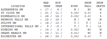 Proverbial Calm Before The Storm. The sun was out (for a time). Staring out the window it was hard to comprehend the storm brewing to our west. 70 years ago we relied on telegraphs to get (current) weather reports - there were no weather models until the early 70s. 100-150 years ago locals relied on postcards with current weather reports - they'd usually arrive days, even weeks after the weather actually arrived. We've made some progress with the advent of Doppler and supercomputers - far from perfect, but part of me wants to believe that another Armistice Day Blizzard would not arrive with no warning. I hope that's the case, but this is a humbling profession, no question. Highs Friday ranged from 8 at International Falls (a taste of what's to come) to 21 in St. Cloud to 26 in the Twin Cities.
 TODAY: Winter Storm Warning - Blizzard Warning south/west of the MSP metro area. Heavy snow, potential for 1-2 feet by tonight with considerable blowing and drifting. Travel will be treacherous. Winds: N 30. High: 20 (early), falling through the teens to near 10 F. by the dinner hour.
SATURDAY NIGHT: Snow tapers to flurries - many roads still impassable. Wind chills dip into the -20 to -40 F. range. Low: -13
SUNDAY: Siberian sun, wind chill: -30. High: -2
MONDAY: Blue sky, most roads finally "dug out". Low: -16. High: 3
TUESDAY: Numbing start. Clouds increase during the day. Low: -8. High: 8
WEDNESDAY: Chance of light snow, coating? High: near 20
THURSDAY: 25 (above) has never felt better... High: 25
FRIDAY: Patchy clouds, few flurries. High: 22
Potentially Crippling?
"Paul, how many inches in MY yard, plus or minus 1 inch, please?" Right. Let me put it to you this way: on the "nuisance-plowable-crippling" scale that I use (ad nauseum) this may wind up being a "crippling storm". That means potential gridlock, parking-lot-conditions, even on the freeways and interstates. The big difference this time around? This will be a cold, powdery snow, prone to blowing and drifting.
Winds increase as temperature tumble through the teens today, visibilities dropping under 1/4 mile, VERY close to blizzard criteria. Only the brave and the foolish will be out on the highways. Running out of gas or veering into a ditch may be more than a minor inconvenience as wind chills dip to -25 F. by tonight. If the heaviest snow bands do, in fact, set up right over the metro area final amounts could be anywhere from 1-2 feet with some 3-5 foot drifts. Depending on the final track, this could wind up being the biggest snowfall for MSP since the Halloween Superstorm of '91.
"And in other news." I hope I'm wrong. I hope the storm misses us and we see "flurries". But the models are coming into alignment. Time to batten down the hatches. We just got our Winter Mojo back.
That snowfall records data page you linked here (and again a few weeks back) appears to have not been updated since 2003. I have to wonder if there would be any data points in there from 2004-2009 if it were up to date - ?
ReplyDelete